Bridge Statistics for Alexandria, Pennsylvania (PA)
Condition, Traffic, Stress, Structural Evaluation, Project Costs
- National Bridge Inventory (NBI) Statistics
- 15Number of bridges
- 223ft / 68.1mTotal length
- $10,426,000Total costs
- 33,655Total average daily traffic
- 3,122Total average daily truck traffic
- National Bridge Inventory (NBI) Registered Bridges for Alexandria
- No street view available for this location
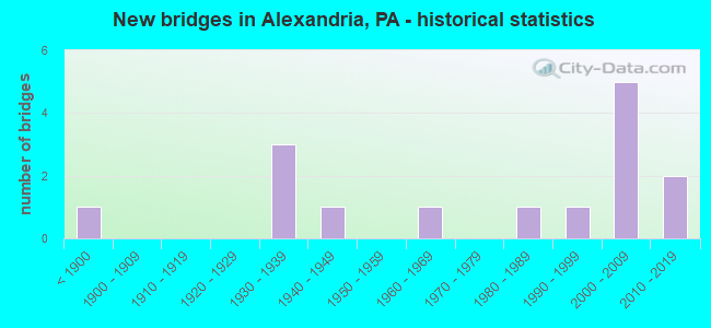
- New bridges - historical statistics
- 1Before 1900
- 31930-1939
- 11940-1949
- 11960-1969
- 11980-1989
- 11990-1999
- 52000-2009
- 22010-2019

- Reconstructed bridges - Historical Statistics
- 11950-1959
- 01960-1969
- 11970-1979
- 01980-1989
- 11990-1999
- 12000-2009
- 22010-2019


- Bridge Condition - Deck
- 20.0%Very good
- 80.0%Good

- Bridge Condition - Superstructure
- 36.4%Very good
- 54.5%Good
- 9.1%Satisfactory

- Bridge Condition - Substructure
- 45.5%Very good
- 36.4%Good
- 18.2%Satisfactory

- Bridge Condition - Channel
- 8.3%Very good
- 33.3%Good
- 33.3%Satisfactory
- 8.3%Fair
- 16.7%Poor
Find on map >> Show street view
Structure Number: 18572, Location: 0.7 MI. E. OF PA 453 (Lat: 40.566878, Lng: -78.124808), Route carried "on" structure: US 22, Year Built: 1941, Year Reconstructed: 2010, Status: Open, Structure Length: 22.07m (72.41ft), Average Daily Traffic: 8,725 (year 2021), Truck Traffic: 13%, Average Future Daily Traffic: 9,099 (year 2032), Design Load: HL 93, Features Intersected: FRANKSTOWN BR. JUNIATA
Minimum Vertical Clearance: 30+ m (98+ ft), Kilometerpoint: 6.153, Lanes on structure: 3, Base Highway Network: Yes, Owner: State Highway Agency, Approaching Roadway Width: 13.1m (43.0ft), Skew: 6 degrees, Material/Design: Steel continuous, Design/Construction: Girder and Floorbeam System, Number Of Spans In Main Unit: 4, Number Of Approach Spans: 1, Length of Maximum Span: 49.4m (162.1ft), Curb or Sidewalk Widths: Left: 1.5m (4.9ft), Right: 0.0m, Curb-To-Curb Width: 11.7m (38.4ft), Out-to-Out Width: 13.9m (45.6ft)
Condition: Deck: Good, Superstructure: Good, Substructure: Good, Channel: Poor, Operating Rating: 66.2 metric tons, Method Used To Determine Operating Rating: Load and Resistance Factor (LRFR), Inventory Rating: 50.8 metric tons, Method Used To Determine Inventory Rating: Load and Resistance Factor (LRFR), Structural Evaluation: Better than present minimum criteria, Deck Geometry: High priority of corrective action, Waterway Adequacy: Superior to present desirable criteria, Approach Roadway Alignment: Equal to present desirable criteria, Length Of Structure Improvement: 27.40m (89.90ft), Designated Inspection Frequency: Every 23 months, Critical Feature Inspection Frequency: Every 23 months, Inspection Date: May 2020, Critical Feature Inspection Date: May 2020, Bridge Improvement Cost: $587,000, Roadway Improvement Cost: $1,729,000, Total Project Cost: $7,925,000, Deck Structure Type: Concrete Cast-file-Place, Wearing Surface/Protective System: Wearing Surface: Epoxy Overlay, Deck Protection: Galvanized Reinforcing
Find on map >> Show street view
Structure Number: 18574, Location: 0.9 MILE EAST OF TR 305 (Lat: 40.539283, Lng: -78.087828), Route carried "on" structure: US 22, Year Built: 1930, Year Reconstructed: 1956, Status: Open, Structure Length: 0.73m (2.40ft), Average Daily Traffic: 9,802 (year 2021), Truck Traffic: 10%, Average Future Daily Traffic: 10,944 (year 2032), Design Load: H 20, Features Intersected: EMMAS CREEK
Minimum Vertical Clearance: 30+ m (98+ ft), Kilometerpoint: 10.665, Lanes on structure: 3, Base Highway Network: Yes, Owner: State Highway Agency, Approaching Roadway Width: 18.0m (59.1ft), Material/Design: Concrete, Design/Construction: Arch - Deck, Number Of Spans In Main Unit: 1, Length of Maximum Span: 7.3m (24.0ft), Curb or Sidewalk Widths: Left: 0.1m (0.3ft), Right: 0.1m (0.3ft), Curb-To-Curb Width: 19.2m (63.0ft), Out-to-Out Width: 20.5m (67.3ft)
Condition: Superstructure: Good, Substructure: Good, Channel: Fair, Operating Rating: 86.2 metric tons, Method Used To Determine Operating Rating: Field evaluation and documented engineering judgment, Inventory Rating: 51.7 metric tons, Method Used To Determine Inventory Rating: Field evaluation and documented engineering judgment, Structural Evaluation: Better than present minimum criteria, Deck Geometry: Superior to present desirable criteria, Waterway Adequacy: Superior to present desirable criteria, Approach Roadway Alignment: Equal to present desirable criteria, Length Of Structure Improvement: 1.40m (4.59ft), Designated Inspection Frequency: Every 24 months, Inspection Date: August 2021
Find on map >> Show street view
Structure Number: 18618, Location: 167 FEET WEST OF SR 4017 (Lat: 40.609044, Lng: -78.136269), Route carried "on" structure: State highway 45, Year Built: 1982, Year Reconstructed: 2018, Status: Open, Structure Length: 3.87m (12.70ft), Average Daily Traffic: 1,227 (year 2020), Truck Traffic: 2%, Average Future Daily Traffic: 1,505 (year 2032), Design Load: HS 20, Features Intersected: LITTLE JUNIATA RIVER
Minimum Vertical Clearance: 30+ m (98+ ft), Kilometerpoint: 4.345, Lanes on structure: 2, Base Highway Network: Yes, Owner: State Highway Agency, Approaching Roadway Width: 8.5m (27.9ft), Material/Design: Prestressed concrete, Design/Construction: Box Beam or Girders - Multiple, Number Of Spans In Main Unit: 2, Length of Maximum Span: 18.9m (62.0ft), Curb or Sidewalk Widths: Left: 1.5m (4.9ft), Right: 0.2m (0.7ft), Curb-To-Curb Width: 8.5m (27.9ft), Out-to-Out Width: 11.2m (36.7ft)
Condition: Deck: Good, Superstructure: Good, Substructure: Good, Channel: Good, Inventory Rating: 44.5 metric tons, Method Used To Determine Inventory Rating: Load Factor (LF), Structural Evaluation: Better than present minimum criteria, Deck Geometry: Somewhat better than minimum adequacy, Waterway Adequacy: Superior to present desirable criteria, Approach Roadway Alignment: Equal to present minimum criteria, Length Of Structure Improvement: 4.70m (15.42ft), Designated Inspection Frequency: Every 48 months, Inspection Date: April 2020, Deck Structure Type: Concrete Cast-file-Place, Wearing Surface/Protective System: Wearing Surface: Epoxy Overlay, Deck Protection: Epoxy Coated Reinforcing
Find on map >> Show street view
Structure Number: 1863, Location: 0.4 MILE EAST OF TR 22 (Lat: 40.555919, Lng: -78.098753), Route carried "on" structure: State highway 305, Year Built: 1994, Status: Open, Structure Length: 7.89m (25.89ft), Average Daily Traffic: 2,694 (year 2022), Truck Traffic: 4%, Average Future Daily Traffic: 2,768 (year 2032), Design Load: HS 25 or greater, Features Intersected: FRNKSTWN.BR.JUNIATA RIV.
Minimum Vertical Clearance: 30+ m (98+ ft), Kilometerpoint: 0.000, Lanes on structure: 2, Owner: State Highway Agency, Approaching Roadway Width: 10.1m (33.1ft), Material/Design: Prestressed concrete, Design/Construction: Box Beam or Girders - Single/Spread, Number Of Spans In Main Unit: 3, Length of Maximum Span: 26.2m (86.0ft), Curb-To-Curb Width: 8.5m (27.9ft), Out-to-Out Width: 11.5m (37.7ft)
Condition: Deck: Good, Superstructure: Satisfactory, Substructure: Satisfactory, Channel: Satisfactory, Operating Rating: 89.8 metric tons, Method Used To Determine Operating Rating: Load Factor (LF), Inventory Rating: 49.0 metric tons, Method Used To Determine Inventory Rating: Load Factor (LF), Structural Evaluation: Equal to present minimum criteria, Deck Geometry: Meets minimum limits, Waterway Adequacy: Equal to present desirable criteria, Approach Roadway Alignment: Equal to present desirable criteria, Length Of Structure Improvement: 8.80m (28.87ft), Designated Inspection Frequency: Every 48 months, Inspection Date: May 2020, Deck Structure Type: Concrete Cast-file-Place, Wearing Surface/Protective System: Wearing Surface: Monolithic Concrete, Deck Protection: Epoxy Coated Reinforcing
Find on map >> Show street view
Structure Number: 18879, Location: 2 MI SE OF ALEXANDRIA (Lat: 40.536678, Lng: -78.077889), Route carried "on" structure: State highway , Year Built: 1889, Year Reconstructed: 2012, Status: Posted for load, Structure Length: 4.85m (15.91ft), Average Daily Traffic: 227 (year 2021), Truck Traffic: 2%, Average Future Daily Traffic: 469 (year 2032), Design Load: HS 20, Features Intersected: FRANKSTOWN BR JUNIATA R, Facility Carried by Structure: SR 4005
Minimum Vertical Clearance: 5.66m (18.57ft), Kilometerpoint: 7.448, Lanes on structure: 1, Owner: State Highway Agency, Approaching Roadway Width: 5.8m (19.0ft), Material/Design: Aluminum, Iron, Design/Construction: Truss - Thru, Number Of Spans In Main Unit: 1, Length of Maximum Span: 46.6m (152.9ft), Curb-To-Curb Width: 4.4m (14.4ft), Out-to-Out Width: 4.9m (16.1ft)
Condition: Deck: Good, Superstructure: Good, Substructure: Very good, Channel: Good, Operating Rating: 49.0 metric tons, Method Used To Determine Operating Rating: Allowable Stress (AS), Inventory Rating: 31.8 metric tons, Method Used To Determine Inventory Rating: Allowable Stress (AS), Structural Evaluation: Better than present minimum criteria, Deck Geometry: High priority of replacement, Waterway Adequacy: Equal to present desirable criteria, Approach Roadway Alignment: Equal to present desirable criteria, Length Of Structure Improvement: 5.90m (19.36ft), Designated Inspection Frequency: Every 24 months, Critical Feature Inspection Frequency: Every 24 months, Other Special Inspection Frequency: Every 12 months, Inspection Date: April 2020, Critical Feature Inspection Date: April 2020, Other Special Inspection Date: April 2021, Bridge Improvement Cost: $143,000, Roadway Improvement Cost: $422,000, Total Project Cost: $1,934,000, Deck Structure Type: Closed Grating, Wearing Surface/Protective System: Wearing Surface: Monolithic Concrete
Find on map >> Show street view
Structure Number: 18929, Location: 2 MI.S.OF ALEXANDRIA (Lat: 40.536453, Lng: -78.088447), Route carried "on" structure: City street , Year Built: 1938, Year Reconstructed: 1983, Status: Open, Structure Length: 0.82m (2.69ft), Average Daily Traffic: 564 (year 2020), Average Future Daily Traffic: 723 (year 2040), Design Load: H 20, Features Intersected: ROBINSON RUN, Facility Carried by Structure: T613, OLD ROUTE 22
Minimum Vertical Clearance: 30+ m (98+ ft), Kilometerpoint: 0.000, Lanes on structure: 2, Owner: Town or Township Highway Agency, Approaching Roadway Width: 5.5m (18.0ft), Skew: 3 degrees, Material/Design: Steel, Design/Construction: Culvert, Number Of Spans In Main Unit: 1, Length of Maximum Span: 8.2m (26.9ft)
Condition: Channel: Satisfactory, Culverts: Fair, Inventory Rating: 99.8 metric tons, Method Used To Determine Inventory Rating: Allowable Stress (AS), Structural Evaluation: Somewhat better than minimum adequacy, Waterway Adequacy: Better than present minimum criteria, Approach Roadway Alignment: Equal to present desirable criteria, Length Of Structure Improvement: 1.00m (3.28ft), Designated Inspection Frequency: Every 24 months, Inspection Date: November 2020, Bridge Improvement Cost: $42,000, Roadway Improvement Cost: $253,000, Total Project Cost: $567,000
Find on map >> Show street view
Structure Number: 1893, Location: 3 MI.S.OF ALEXANDRIA (Lat: 40.530414, Lng: -78.117728), Route carried "on" structure: City street , Year Built: 1963, Status: Open, Structure Length: 0.67m (2.20ft), Average Daily Traffic: 410 (year 2020), Truck Traffic: 7%, Average Future Daily Traffic: 526 (year 2040), Features Intersected: EMMA CREEK, Facility Carried by Structure: T-616, LOOP ROAD
Minimum Vertical Clearance: 30+ m (98+ ft), Kilometerpoint: 0.000, Lanes on structure: 2, Owner: Town or Township Highway Agency, Approaching Roadway Width: 5.5m (18.0ft), Skew: 4 degrees, Material/Design: Steel, Design/Construction: Culvert, Number Of Spans In Main Unit: 1, Length of Maximum Span: 6.7m (22.0ft)
Condition: Channel: Poor, Culverts: Fair, Operating Rating: 32.7 metric tons, Method Used To Determine Operating Rating: Field evaluation and documented engineering judgment, Inventory Rating: 19.1 metric tons, Method Used To Determine Inventory Rating: Field evaluation and documented engineering judgment, Structural Evaluation: Somewhat better than minimum adequacy, Waterway Adequacy: Better than present minimum criteria, Approach Roadway Alignment: Equal to present desirable criteria, Length Of Structure Improvement: 1.30m (4.27ft), Designated Inspection Frequency: Every 24 months, Inspection Date: November 2020
Find on map >> Show street view
Structure Number: 18939, Location: SPRUCE CREEK (Lat: 40.608681, Lng: -78.135519), Route carried "on" structure: City street , Year Built: 1930, Year Reconstructed: 1996, Status: Open, Structure Length: 2.10m (6.89ft), Average Daily Traffic: 51 (year 2020), Truck Traffic: 1%, Average Future Daily Traffic: 65 (year 2040), Design Load: HS 25 or greater, Features Intersected: SPRUCE CREEK, Facility Carried by Structure: T513, RIVERSIDE DR
Minimum Vertical Clearance: 30+ m (98+ ft), Kilometerpoint: 0.000, Lanes on structure: 1, Owner: Town or Township Highway Agency, Approaching Roadway Width: 3.7m (12.1ft), Material/Design: Steel continuous, Design/Construction: Stringer/Multi-beam, Number Of Spans In Main Unit: 2, Length of Maximum Span: 10.1m (33.1ft), Curb-To-Curb Width: 4.7m (15.4ft), Out-to-Out Width: 5.2m (17.1ft)
Condition: Deck: Good, Superstructure: Good, Substructure: Satisfactory, Channel: Satisfactory, Operating Rating: 56.2 metric tons, Method Used To Determine Operating Rating: Load Factor (LF), Inventory Rating: 33.6 metric tons, Method Used To Determine Inventory Rating: Load Factor (LF), Structural Evaluation: Equal to present minimum criteria, Deck Geometry: Better than present minimum criteria, Waterway Adequacy: Better than present minimum criteria, Approach Roadway Alignment: Better than present minimum criteria, Length Of Structure Improvement: 2.80m (9.19ft), Designated Inspection Frequency: Every 24 months, Inspection Date: August 2020, Deck Structure Type: Concrete Cast-file-Place, Wearing Surface/Protective System: Wearing Surface: Monolithic Concrete, Deck Protection: Epoxy Coated Reinforcing
Find on map >> Show street view
Structure Number: 4137, Location: 1 MI SW PA 453,WATER ST (Lat: 40.560467, Lng: -78.155203), Route carried "on" structure: US 22, Year Built: 2001, Status: Open, Structure Length: 3.54m (11.61ft), Average Daily Traffic: 4,212 (year 2020), Truck Traffic: 9%, Average Future Daily Traffic: 4,640 (year 2032), Design Load: HS 25 or greater, Features Intersected: TWP RD T-482(GOODMAN RD)
Minimum Vertical Clearance: 30+ m (98+ ft), Kilometerpoint: 3.111, Lanes on structure: 3, Lanes under structure: 2, Base Highway Network: Yes, Owner: State Highway Agency, Approaching Roadway Width: 17.7m (58.1ft), Skew: 2 degrees, Material/Design: Prestressed concrete, Design/Construction: Stringer/Multi-beam, Number Of Spans In Main Unit: 1, Length of Maximum Span: 33.5m (109.9ft), Curb or Sidewalk Widths: Left: 0.2m (0.7ft), Right: 0.2m (0.7ft), Curb-To-Curb Width: 17.1m (56.1ft), Out-to-Out Width: 18.0m (59.1ft)
Condition: Deck: Good, Superstructure: Very good, Substructure: Very good, Operating Rating: 89.8 metric tons, Method Used To Determine Operating Rating: Load Factor (LF), Inventory Rating: 50.8 metric tons, Method Used To Determine Inventory Rating: Load Factor (LF), Structural Evaluation: Equal to present desirable criteria, Deck Geometry: Superior to present desirable criteria, Underclear: High priority of corrective action, Approach Roadway Alignment: Equal to present desirable criteria, Length Of Structure Improvement: 4.40m (14.44ft), Designated Inspection Frequency: Every 48 months, Inspection Date: September 2019, Deck Structure Type: Concrete Cast-file-Place, Wearing Surface/Protective System: Wearing Surface: Monolithic Concrete, Deck Protection: Epoxy Coated Reinforcing
Find on map >> Show street view
Structure Number: 41371, Location: .2 M SW PA453(WATER ST) (Lat: 40.569308, Lng: -78.142039), Route carried "on" structure: US 22, Year Built: 2001, Status: Open, Structure Length: 13.87m (45.51ft), Average Daily Traffic: 4,212 (year 2020), Truck Traffic: 9%, Average Future Daily Traffic: 4,640 (year 2032), Design Load: HL 93, Features Intersected: SR 4016 & SHAFFERS RUN
Minimum Vertical Clearance: 30+ m (98+ ft), Kilometerpoint: 4.511, Lanes on structure: 3, Lanes under structure: 2, Base Highway Network: Yes, Owner: State Highway Agency, Approaching Roadway Width: 17.1m (56.1ft), Material/Design: Prestressed concrete, Design/Construction: Stringer/Multi-beam, Number Of Spans In Main Unit: 3, Length of Maximum Span: 45.7m (149.9ft), Curb-To-Curb Width: 17.1m (56.1ft), Out-to-Out Width: 18.0m (59.1ft)
Condition: Deck: Good, Superstructure: Very good, Substructure: Very good, Channel: Good, Operating Rating: 70.8 metric tons, Method Used To Determine Operating Rating: Load and Resistance Factor (LRFR), Inventory Rating: 39.0 metric tons, Method Used To Determine Inventory Rating: Load and Resistance Factor (LRFR), Structural Evaluation: Equal to present desirable criteria, Deck Geometry: Superior to present desirable criteria, Underclear: Superior to present desirable criteria, Waterway Adequacy: Superior to present desirable criteria, Approach Roadway Alignment: Equal to present desirable criteria, Length Of Structure Improvement: 14.80m (48.56ft), Designated Inspection Frequency: Every 48 months, Inspection Date: June 2020, Deck Structure Type: Concrete Cast-file-Place, Wearing Surface/Protective System: Wearing Surface: Monolithic Concrete, Deck Protection: Epoxy Coated Reinforcing
Find on map >> Show street view
Structure Number: 41564, Location: SHAFFERSVILLE (Lat: 40.569386, Lng: -78.143153), Route carried "on" structure: State highway , Year Built: 2002, Status: Open, Structure Length: 1.49m (4.89ft), Average Daily Traffic: 113 (year 2021), Truck Traffic: 7%, Average Future Daily Traffic: 143 (year 2032), Design Load: HS 25 or greater, Features Intersected: SHAFFERS RUN, Facility Carried by Structure: SR 4016(OLD US 22)
Minimum Vertical Clearance: 30+ m (98+ ft), Kilometerpoint: 1.617, Lanes on structure: 2, Owner: State Highway Agency, Approaching Roadway Width: 9.8m (32.2ft), Skew: 4 degrees, Material/Design: Prestressed concrete, Design/Construction: Box Beam or Girders - Single/Spread, Number Of Spans In Main Unit: 1, Length of Maximum Span: 14.3m (46.9ft), Curb or Sidewalk Widths: Left: 0.2m (0.7ft), Right: 0.2m (0.7ft), Curb-To-Curb Width: 9.1m (29.9ft), Out-to-Out Width: 10.0m (32.8ft)
Condition: Deck: Good, Superstructure: Very good, Substructure: Good, Channel: Satisfactory, Operating Rating: 81.6 metric tons, Method Used To Determine Operating Rating: Load Factor (LF), Inventory Rating: 43.5 metric tons, Method Used To Determine Inventory Rating: Load Factor (LF), Structural Evaluation: Better than present minimum criteria, Deck Geometry: Equal to present minimum criteria, Waterway Adequacy: Better than present minimum criteria, Approach Roadway Alignment: Equal to present desirable criteria, Length Of Structure Improvement: 2.20m (7.22ft), Designated Inspection Frequency: Every 48 months, Inspection Date: August 2019, Deck Structure Type: Concrete Cast-file-Place, Wearing Surface/Protective System: Wearing Surface: Monolithic Concrete, Deck Protection: Epoxy Coated Reinforcing
Find on map >> Show street view
Structure Number: 46188, Location: VILLAGE OF BARREE (Lat: 40.587072, Lng: -78.100469), Route carried "on" structure: State highway , Year Built: 2010, Status: Open, Structure Length: 4.88m (16.01ft), Average Daily Traffic: 544 (year 2022), Truck Traffic: 8%, Average Future Daily Traffic: 701 (year 2032), Design Load: HL 93, Features Intersected: LITTLE JUNIATA RIVER, Facility Carried by Structure: SR 4004
Minimum Vertical Clearance: 30+ m (98+ ft), Kilometerpoint: 3.822, Lanes on structure: 2, Owner: State Highway Agency, Approaching Roadway Width: 7.6m (24.9ft), Skew: 1 degrees, Material/Design: Prestressed concrete, Design/Construction: Box Beam or Girders - Single/Spread, Number Of Spans In Main Unit: 2, Length of Maximum Span: 23.8m (78.1ft), Curb or Sidewalk Widths: Left: 0.2m (0.7ft), Right: 0.2m (0.7ft), Curb-To-Curb Width: 7.3m (24.0ft), Out-to-Out Width: 8.4m (27.6ft)
Condition: Deck: Very good, Superstructure: Good, Substructure: Very good, Channel: Very good, Operating Rating: 63.5 metric tons, Method Used To Determine Operating Rating: Load and Resistance Factor (LRFR), Inventory Rating: 37.2 metric tons, Method Used To Determine Inventory Rating: Load and Resistance Factor (LRFR), Structural Evaluation: Better than present minimum criteria, Deck Geometry: Meets minimum limits, Waterway Adequacy: Equal to present desirable criteria, Approach Roadway Alignment: Equal to present minimum criteria, Length Of Structure Improvement: 4.90m (16.08ft), Designated Inspection Frequency: Every 24 months, Inspection Date: July 2021, Deck Structure Type: Concrete Cast-file-Place, Wearing Surface/Protective System: Wearing Surface: Monolithic Concrete, Deck Protection: Epoxy Coated Reinforcing
Find on map >> Show street view
Structure Number: 48259, Location: 2.5 MI S OF ALEXANDRIA (Lat: 40.521244, Lng: -78.094675), Route carried "on" structure: State highway , Year Built: 2013, Status: Open, Structure Length: 1.28m (4.20ft), Average Daily Traffic: 760 (year 2021), Truck Traffic: 4%, Average Future Daily Traffic: 1,257 (year 2033), Design Load: HL 93, Features Intersected: ROBINSON RUN, Facility Carried by Structure: T613 OLD RTE 22 RD
Minimum Vertical Clearance: 30+ m (98+ ft), Kilometerpoint: 0.006, Lanes on structure: 2, Owner: State Highway Agency, Approaching Roadway Width: 7.3m (24.0ft), Material/Design: Prestressed concrete, Design/Construction: Box Beam or Girders - Single/Spread, Number Of Spans In Main Unit: 1, Length of Maximum Span: 12.2m (40.0ft), Curb or Sidewalk Widths: Left: 0.2m (0.7ft), Right: 0.2m (0.7ft), Curb-To-Curb Width: 7.3m (24.0ft), Out-to-Out Width: 8.4m (27.6ft)
Condition: Deck: Very good, Superstructure: Very good, Substructure: Very good, Channel: Good, Operating Rating: 52.8 metric tons, Method Used To Determine Operating Rating: Assigned ratings based on Load and Resistance Factor Design (LRFD) reported by rating factor (RF) using HL93 loadings, Inventory Rating: 33.4 metric tons, Method Used To Determine Inventory Rating: Assigned ratings based on Load and Resistance Factor Design (LRFD) reported by rating factor (RF) using HL93 loadings, Structural Evaluation: Equal to present desirable criteria, Deck Geometry: Meets minimum limits, Waterway Adequacy: Better than present minimum criteria, Approach Roadway Alignment: Equal to present desirable criteria, Designated Inspection Frequency: Every 48 months, Inspection Date: January 2019, Deck Structure Type: Concrete Cast-file-Place, Wearing Surface/Protective System: Wearing Surface: Epoxy Overlay, Deck Protection: Epoxy Coated Reinforcing
Find on map >> Show street view
Structure Number: 4137, Location: 1 MI SW PA 453,WATER ST (Lat: 40.560467, Lng: -78.155203), Route carried "under" structure: ServiceCity street , Year Built: 2001, Structure Length: 0. m, Average Daily Traffic: 1 (year 2003), Features Intersected: TWP RD T-482(GOODMAN RD), Facility Carried by Structure: US 22
Minimum Vertical Clearance: 5.28m (17.32ft), Kilometerpoint: 0.000, Lanes on structure: 3, Lanes under structure: 2, Material/Design: Prestressed concrete, Design/Construction: Stringer/Multi-beam, Length of Maximum Span: 33.5m (109.9ft)
Find on map >> Show street view
Structure Number: 41371, Location: .2 M SW PA453(WATER ST) (Lat: 40.569308, Lng: -78.142039), Route carried "under" structure: State highway , Year Built: 2001, Structure Length: 0. m, Average Daily Traffic: 113 (year 2021), Truck Traffic: 7%, Features Intersected: SR 4016 & SHAFFERS RUN, Facility Carried by Structure: US 22
Minimum Vertical Clearance: 6.27m (20.57ft), Kilometerpoint: 1.617, Lanes on structure: 3, Lanes under structure: 2, Material/Design: Prestressed concrete, Design/Construction: Stringer/Multi-beam, Length of Maximum Span: 45.7m (149.9ft)