Bridge Statistics for Alta Vista, Iowa (IA)
Condition, Traffic, Stress, Structural Evaluation, Project Costs
- National Bridge Inventory (NBI) Statistics
- 22Number of bridges
- 226ft / 69.3mTotal length
- 17,405Total average daily traffic
- 4,372Total average daily truck traffic
- 18,095Total future (year 2039) average daily traffic
- National Bridge Inventory (NBI) Registered Bridges for Alta Vista
- No street view available for this location
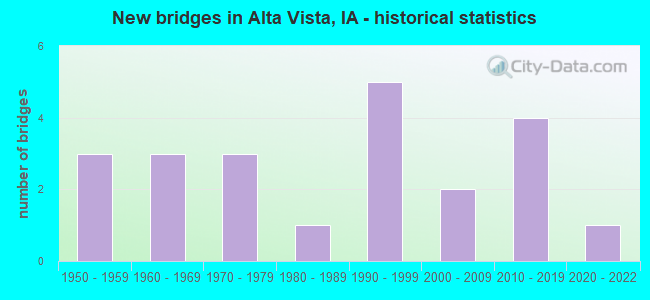
- New bridges - historical statistics
- 31950-1959
- 31960-1969
- 31970-1979
- 11980-1989
- 51990-1999
- 22000-2009
- 42010-2019
- 12020-2022

- Reconstructed bridges - Historical Statistics
- 11960-1969
- 11970-1979
- 11980-1989


- Bridge Condition - Deck
- 5.0%Excellent
- 35.0%Very good
- 20.0%Good
- 20.0%Satisfactory
- 10.0%Fair
- 10.0%Poor

- Bridge Condition - Superstructure
- 5.0%Excellent
- 25.0%Very good
- 30.0%Good
- 20.0%Satisfactory
- 15.0%Fair
- 5.0%Poor

- Bridge Condition - Substructure
- 5.0%Excellent
- 30.0%Very good
- 35.0%Good
- 10.0%Satisfactory
- 20.0%Poor

- Bridge Condition - Channel
- 4.8%Excellent
- 14.3%Very good
- 61.9%Good
- 14.3%Satisfactory
- 4.8%Fair

- Bridge Condition - Culverts
- 50.0%Excellent
- 50.0%Good
Find on map >> Show street view
Structure Number: 136, Location: 097133018 (Lat: 43.198531, Lng: -92.420100), Route carried "on" structure: City street , Year Built: 2020, Status: Open, Structure Length: 3.99m (13.09ft), Average Daily Traffic: 670 (year 2021), Average Future Daily Traffic: 670 (year 2040), Design Load: HL 93, Features Intersected: ELK CREEK, Facility Carried by Structure: WEBER ST
Minimum Vertical Clearance: 30+ m (98+ ft), Kilometerpoint: 0.544, Lanes on structure: 2, Owner: County Highway Agency, Approaching Roadway Width: 10.4m (34.1ft), Skew: 3 degrees, Material/Design: Concrete continuous, Design/Construction: Slab, Number Of Spans In Main Unit: 3, Length of Maximum Span: 15.5m (50.9ft), Curb-To-Curb Width: 9.3m (30.5ft), Out-to-Out Width: 10.1m (33.1ft)
Condition: Deck: Excellent, Superstructure: Excellent, Substructure: Excellent, Channel: Excellent, Operating Rating: 42.1 metric tons, Method Used To Determine Operating Rating: Assigned ratings based on Load and Resistance Factor Design (LRFD) reported by rating factor (RF) using HL93 loadings, Inventory Rating: 32.4 metric tons, Method Used To Determine Inventory Rating: Assigned ratings based on Load and Resistance Factor Design (LRFD) reported by rating factor (RF) using HL93 loadings, Structural Evaluation: Equal to present desirable criteria, Deck Geometry: Equal to present minimum criteria, Waterway Adequacy: Superior to present desirable criteria, Approach Roadway Alignment: Better than present minimum criteria, Designated Inspection Frequency: Every 24 months, Inspection Date: October 2020, Deck Structure Type: Concrete Cast-file-Place, Wearing Surface/Protective System: Wearing Surface: Monolithic Concrete, Deck Protection: Epoxy Coated Reinforcing
Find on map >> Show street view
Structure Number: 2298, Location: 4.5 mi. N of Jct. IA 2 (Lat: 40.801744, Lng: -93.831156), Route carried "on" structure: County highway , Year Built: 1969, Status: Open, Structure Length: 10.49m (34.42ft), Average Daily Traffic: 50 (year 2016), Average Future Daily Traffic: 50 (year 2041), Design Load: HS 20, Features Intersected: I 35, Facility Carried by Structure: FM
Minimum Vertical Clearance: 30+ m (98+ ft), Kilometerpoint: 7.657, Lanes on structure: 2, Lanes under structure: 4, Owner: State Highway Agency, Approaching Roadway Width: 8.5m (27.9ft), Skew: 3 degrees, Material/Design: Steel continuous, Design/Construction: Stringer/Multi-beam, Number Of Spans In Main Unit: 4, Length of Maximum Span: 32.9m (107.9ft), Curb or Sidewalk Widths: Left: 0.3m (1.0ft), Right: 0.3m (1.0ft), Curb-To-Curb Width: 9.8m (32.2ft), Out-to-Out Width: 10.8m (35.4ft)
Condition: Deck: Satisfactory, Superstructure: Satisfactory, Substructure: Good, Operating Rating: 55.4 metric tons, Method Used To Determine Operating Rating: Load Factor (LF), Inventory Rating: 33.3 metric tons, Method Used To Determine Inventory Rating: Load Factor (LF), Structural Evaluation: Equal to present minimum criteria, Deck Geometry: Equal to present desirable criteria, Underclear: Somewhat better than minimum adequacy, Approach Roadway Alignment: Meets minimum limits, Designated Inspection Frequency: Every 24 months, Inspection Date: July 2021, Deck Structure Type: Concrete Cast-file-Place, Wearing Surface/Protective System: Wearing Surface: Monolithic Concrete
Find on map >> Show street view
Structure Number: 2864, Location: 072062804 (Lat: 41.006614, Lng: -91.551703), Route carried "on" structure: County highway , Year Built: 1959, Status: Open, Structure Length: 4.85m (15.91ft), Average Daily Traffic: 1,080 (year 2018), Truck Traffic: 4%, Average Future Daily Traffic: 1,080 (year 2040), Design Load: H 20, Features Intersected: BIG CREEK, Facility Carried by Structure: FM
Minimum Vertical Clearance: 30+ m (98+ ft), Kilometerpoint: 11.415, Lanes on structure: 2, Owner: County Highway Agency, Approaching Roadway Width: 13.4m (44.0ft), Material/Design: Prestressed concrete, Design/Construction: Stringer/Multi-beam, Number Of Spans In Main Unit: 3, Length of Maximum Span: 15.9m (52.2ft), Curb or Sidewalk Widths: Left: 0.6m (2.0ft), Right: 0.6m (2.0ft), Curb-To-Curb Width: 9.1m (29.9ft), Out-to-Out Width: 11.0m (36.1ft)
Condition: Deck: Poor, Superstructure: Fair, Substructure: Poor, Channel: Satisfactory, Operating Rating: 45.5 metric tons, Method Used To Determine Operating Rating: Load Factor (LF), Inventory Rating: 27.3 metric tons, Method Used To Determine Inventory Rating: Load Factor (LF), Structural Evaluation: Meets minimum limits, Deck Geometry: Somewhat better than minimum adequacy, Waterway Adequacy: Equal to present desirable criteria, Approach Roadway Alignment: Better than present minimum criteria, Length Of Structure Improvement: 17.00m (55.77ft), Designated Inspection Frequency: Every 24 months, Inspection Date: Febuary 2020, Bridge Improvement Cost: $315,000, Roadway Improvement Cost: $20,000, Deck Structure Type: Concrete Cast-file-Place, Wearing Surface/Protective System: Wearing Surface: Monolithic Concrete
Find on map >> Show street view
Structure Number: 3125, Location: 3.2 MI. E OF JCT IA 224 (Lat: 41.695208, Lng: -92.843714), Route carried "on" structure: Interstate 80, Year Built: 1962, Year Reconstructed: 1979, Status: Open, Structure Length: 5.58m (18.31ft), Average Daily Traffic: 13,100 (year 2020), Truck Traffic: 30%, Average Future Daily Traffic: 13,100 (year 2040), Design Load: HS 20, Features Intersected: ROCK CREEK
Minimum Vertical Clearance: 30+ m (98+ ft), Kilometerpoint: 209.463, Lanes on structure: 2, Owner: State Highway Agency, Approaching Roadway Width: 14.6m (47.9ft), Material/Design: Prestressed concrete, Design/Construction: Stringer/Multi-beam, Number Of Spans In Main Unit: 3, Length of Maximum Span: 21.0m (68.9ft), Curb-To-Curb Width: 11.9m (39.0ft), Out-to-Out Width: 12.9m (42.3ft)
Condition: Deck: Satisfactory, Superstructure: Good, Substructure: Good, Channel: Good, Operating Rating: 60.4 metric tons, Method Used To Determine Operating Rating: Load Factor (LF), Inventory Rating: 49.3 metric tons, Method Used To Determine Inventory Rating: Load Factor (LF), Structural Evaluation: Better than present minimum criteria, Deck Geometry: Equal to present minimum criteria, Waterway Adequacy: Better than present minimum criteria, Approach Roadway Alignment: Equal to present desirable criteria, Designated Inspection Frequency: Every 24 months, Inspection Date: June 2020, Deck Structure Type: Concrete Cast-file-Place, Wearing Surface/Protective System: Wearing Surface: Low Slump Concrete
Find on map >> Show street view
Structure Number: 3252, Location: 0.8 mi. N of Jct. IA 64 (Lat: 42.070611, Lng: -91.014833), Route carried "on" structure: State highway 136, Year Built: 1952, Status: Open, Structure Length: 3.41m (11.19ft), Average Daily Traffic: 830 (year 2020), Truck Traffic: 17%, Average Future Daily Traffic: 830 (year 2040), Design Load: H 20, Features Intersected: LITTLE BEAR CREEK
Minimum Vertical Clearance: 30+ m (98+ ft), Kilometerpoint: 89.702, Lanes on structure: 2, Base Highway Network: Yes, Owner: State Highway Agency, Approaching Roadway Width: 9.8m (32.2ft), Skew: 3 degrees, Material/Design: Concrete continuous, Design/Construction: Slab, Number Of Spans In Main Unit: 3, Length of Maximum Span: 12.8m (42.0ft), Curb-To-Curb Width: 8.0m (26.2ft), Out-to-Out Width: 10.0m (32.8ft)
Condition: Deck: Satisfactory, Superstructure: Satisfactory, Substructure: Good, Channel: Good, Operating Rating: 49.9 metric tons, Method Used To Determine Operating Rating: Load Factor (LF), Inventory Rating: 29.9 metric tons, Method Used To Determine Inventory Rating: Load Factor (LF), Structural Evaluation: Equal to present minimum criteria, Deck Geometry: Somewhat better than minimum adequacy, Waterway Adequacy: Equal to present minimum criteria, Approach Roadway Alignment: Better than present minimum criteria, Designated Inspection Frequency: Every 24 months, Inspection Date: November 2020, Deck Structure Type: Concrete Cast-file-Place, Wearing Surface/Protective System: Wearing Surface: Low Slump Concrete
Find on map >> Show street view
Structure Number: 3253, Location: 2.5 mi S of S Jct. SR E17 (Lat: 42.131964, Lng: -91.014239), Route carried "on" structure: State highway 136, Year Built: 1955, Status: Open, Structure Length: 1.77m (5.81ft), Average Daily Traffic: 720 (year 2020), Truck Traffic: 19%, Average Future Daily Traffic: 720 (year 2040), Design Load: H 20, Features Intersected: MINERAL CREEK
Minimum Vertical Clearance: 30+ m (98+ ft), Kilometerpoint: 96.514, Lanes on structure: 2, Base Highway Network: Yes, Owner: State Highway Agency, Approaching Roadway Width: 9.8m (32.2ft), Skew: 3 degrees, Material/Design: Concrete continuous, Design/Construction: Culvert, Number Of Spans In Main Unit: 3, Length of Maximum Span: 6.4m (21.0ft)
Condition: Channel: Good, Culverts: Good, Operating Rating: 30.8 metric tons, Method Used To Determine Operating Rating: Field evaluation and documented engineering judgment, Inventory Rating: 22.7 metric tons, Method Used To Determine Inventory Rating: Field evaluation and documented engineering judgment, Structural Evaluation: Equal to present minimum criteria, Waterway Adequacy: Equal to present minimum criteria, Approach Roadway Alignment: Equal to present desirable criteria, Designated Inspection Frequency: Every 24 months, Inspection Date: April 2020
Find on map >> Show street view
Structure Number: 11236, Location: 096130202 (Lat: 43.160025, Lng: -92.357636), Route carried "on" structure: County highway , Year Built: 1970, Year Reconstructed: 1974, Status: Open, Structure Length: 1.43m (4.69ft), Average Daily Traffic: 40 (year 2013), Average Future Daily Traffic: 40 (year 2041), Features Intersected: BR E FORK WAPSIPINICON, Facility Carried by Structure: LOCAL
Minimum Vertical Clearance: 30+ m (98+ ft), Kilometerpoint: 19.726, Lanes on structure: 2, Owner: County Highway Agency, Approaching Roadway Width: 8.5m (27.9ft), Material/Design: Wood or Timber, Design/Construction: Stringer/Multi-beam, Number Of Spans In Main Unit: 2, Length of Maximum Span: 7.0m (23.0ft), Curb-To-Curb Width: 7.3m (24.0ft), Out-to-Out Width: 7.4m (24.3ft)
Condition: Deck: Fair, Superstructure: Satisfactory, Substructure: Poor, Channel: Satisfactory, Operating Rating: 40.0 metric tons, Method Used To Determine Operating Rating: Allowable Stress (AS), Inventory Rating: 32.0 metric tons, Method Used To Determine Inventory Rating: Allowable Stress (AS), Structural Evaluation: Meets minimum limits, Deck Geometry: Equal to present minimum criteria, Waterway Adequacy: Equal to present minimum criteria, Approach Roadway Alignment: Better than present minimum criteria, Length Of Structure Improvement: 4.70m (15.42ft), Designated Inspection Frequency: Every 24 months, Inspection Date: March 2021, Bridge Improvement Cost: $15,000, Roadway Improvement Cost: $2,000, Deck Structure Type: Wood or Timber, Wearing Surface/Protective System: Wearing Surface: Gravel
Find on map >> Show street view
Structure Number: 112372, Location: 96130302 (Lat: 43.166300, Lng: -92.377456), Route carried "on" structure: County highway , Year Built: 2016, Status: Posted for load-capacity, Structure Length: 1.83m (6.00ft), Average Daily Traffic: 40 (year 2013), Average Future Daily Traffic: 40 (year 2041), Features Intersected: E WAPSIPINICON RIVER, Facility Carried by Structure: IVANHOE AVE
Minimum Vertical Clearance: 30+ m (98+ ft), Kilometerpoint: 25.703, Lanes on structure: 2, Owner: County Highway Agency, Approaching Roadway Width: 7.3m (24.0ft), Material/Design: Steel, Design/Construction: Stringer/Multi-beam, Number Of Spans In Main Unit: 2, Length of Maximum Span: 9.1m (29.9ft), Curb-To-Curb Width: 7.0m (23.0ft), Out-to-Out Width: 7.3m (24.0ft)
Condition: Deck: Very good, Superstructure: Fair, Substructure: Very good, Channel: Very good, Operating Rating: 38.2 metric tons, Method Used To Determine Operating Rating: Load Factor (LF), Inventory Rating: 22.9 metric tons, Method Used To Determine Inventory Rating: Load Factor (LF), Structural Evaluation: Somewhat better than minimum adequacy, Deck Geometry: Somewhat better than minimum adequacy, Waterway Adequacy: Better than present minimum criteria, Approach Roadway Alignment: Equal to present desirable criteria, Bridge Posting: Required (Relationship of Operating Rating to Maximum Legal Load: 0.1 - 9.9% below), Designated Inspection Frequency: Every 24 months, Inspection Date: March 2021, Deck Structure Type: Wood or Timber, Wearing Surface/Protective System: Wearing Surface: Gravel
Find on map >> Show street view
Structure Number: 112391, Location: 096130601 (Lat: 43.169358, Lng: -92.433781), Route carried "on" structure: County highway , Year Built: 1991, Status: Open, Structure Length: 3.90m (12.80ft), Average Daily Traffic: 30 (year 2013), Average Future Daily Traffic: 30 (year 2039), Design Load: HS 20, Features Intersected: ELK CREEK, Facility Carried by Structure: LOCAL
Minimum Vertical Clearance: 30+ m (98+ ft), Kilometerpoint: 9.814, Lanes on structure: 2, Owner: County Highway Agency, Approaching Roadway Width: 7.9m (25.9ft), Skew: 3 degrees, Material/Design: Concrete continuous, Design/Construction: Slab, Number Of Spans In Main Unit: 3, Length of Maximum Span: 14.9m (48.9ft), Curb-To-Curb Width: 8.1m (26.6ft), Out-to-Out Width: 8.3m (27.2ft)
Condition: Deck: Very good, Superstructure: Very good, Substructure: Very good, Channel: Very good, Operating Rating: 65.9 metric tons, Method Used To Determine Operating Rating: Allowable Stress (AS), Inventory Rating: 38.7 metric tons, Method Used To Determine Inventory Rating: Allowable Stress (AS), Structural Evaluation: Equal to present desirable criteria, Deck Geometry: Equal to present minimum criteria, Waterway Adequacy: Better than present minimum criteria, Approach Roadway Alignment: Better than present minimum criteria, Length Of Structure Improvement: 12.80m (41.99ft), Designated Inspection Frequency: Every 48 months, Inspection Date: April 2019, Bridge Improvement Cost: $15,000, Roadway Improvement Cost: $2,000, Deck Structure Type: Concrete Cast-file-Place, Wearing Surface/Protective System: Wearing Surface: Monolithic Concrete
Find on map >> Show street view
Structure Number: 1124, Location: 096130701 (Lat: 43.155636, Lng: -92.435661), Route carried "on" structure: County highway , Year Built: 1961, Year Reconstructed: 1989, Status: Posted for load, Structure Length: 5.18m (16.99ft), Average Daily Traffic: 270 (year 2021), Truck Traffic: 34%, Average Future Daily Traffic: 270 (year 2040), Features Intersected: LITTLE WAPSIPINICON RIVE, Facility Carried by Structure: FM
Minimum Vertical Clearance: 30+ m (98+ ft), Kilometerpoint: 9.658, Lanes on structure: 2, Owner: County Highway Agency, Approaching Roadway Width: 10.4m (34.1ft), Material/Design: Prestressed concrete, Design/Construction: Stringer/Multi-beam, Number Of Spans In Main Unit: 3, Length of Maximum Span: 17.1m (56.1ft), Curb-To-Curb Width: 7.8m (25.6ft), Out-to-Out Width: 7.8m (25.6ft)
Condition: Deck: Poor, Superstructure: Poor, Substructure: Poor, Channel: Fair, Operating Rating: 14.8 metric tons, Method Used To Determine Operating Rating: Allowable Stress (AS), Inventory Rating: 3.3 metric tons, Method Used To Determine Inventory Rating: Allowable Stress (AS), Structural Evaluation: High priority of replacement, Deck Geometry: Somewhat better than minimum adequacy, Waterway Adequacy: Better than present minimum criteria, Approach Roadway Alignment: Better than present minimum criteria, Bridge Posting: Required (Relationship of Operating Rating to Maximum Legal Load: > 39.9% below), Length Of Structure Improvement: 20.00m (65.62ft), Designated Inspection Frequency: Every 24 months, Underwater Inspection Frequency: Every 60 months, Inspection Date: March 2020, Underwater Inspection Date: October 2017, Bridge Improvement Cost: $600,000, Roadway Improvement Cost: $60,000, Deck Structure Type: Concrete Cast-file-Place, Wearing Surface/Protective System: Wearing Surface: Low Slump Concrete
Find on map >> Show street view
Structure Number: 112421, Location: 096130901 (Lat: 43.156336, Lng: -92.388633), Route carried "on" structure: County highway , Year Built: 1988, Status: Open, Structure Length: 2.38m (7.81ft), Average Daily Traffic: 30 (year 2013), Average Future Daily Traffic: 30 (year 2039), Design Load: HS 20, Features Intersected: EAST WAPSIPINICON RIVER, Facility Carried by Structure: LOCAL
Minimum Vertical Clearance: 30+ m (98+ ft), Kilometerpoint: 13.483, Lanes on structure: 2, Owner: County Highway Agency, Approaching Roadway Width: 7.3m (24.0ft), Skew: 3 degrees, Material/Design: Concrete continuous, Design/Construction: Slab, Number Of Spans In Main Unit: 3, Length of Maximum Span: 8.8m (28.9ft), Curb-To-Curb Width: 7.8m (25.6ft), Out-to-Out Width: 7.9m (25.9ft)
Condition: Deck: Good, Superstructure: Good, Substructure: Good, Channel: Good, Operating Rating: 62.0 metric tons, Method Used To Determine Operating Rating: Allowable Stress (AS), Inventory Rating: 36.6 metric tons, Method Used To Determine Inventory Rating: Allowable Stress (AS), Structural Evaluation: Better than present minimum criteria, Deck Geometry: Equal to present minimum criteria, Waterway Adequacy: Better than present minimum criteria, Approach Roadway Alignment: Better than present minimum criteria, Length Of Structure Improvement: 7.80m (25.59ft), Designated Inspection Frequency: Every 48 months, Inspection Date: April 2019, Bridge Improvement Cost: $15,000, Roadway Improvement Cost: $2,000, Deck Structure Type: Concrete Cast-file-Place, Wearing Surface/Protective System: Wearing Surface: Monolithic Concrete
Find on map >> Show street view
Structure Number: 112431, Location: 096131001 (Lat: 43.156358, Lng: -92.366808), Route carried "on" structure: County highway , Year Built: 2000, Status: Open, Structure Length: 1.07m (3.51ft), Average Daily Traffic: 30 (year 2013), Average Future Daily Traffic: 30 (year 2040), Design Load: HS 20, Features Intersected: CREEK, Facility Carried by Structure: 140TH ST
Minimum Vertical Clearance: 30+ m (98+ ft), Kilometerpoint: 15.258, Lanes on structure: 2, Owner: County Highway Agency, Approaching Roadway Width: 6.7m (22.0ft), Material/Design: Prestressed concrete, Design/Construction: Tee Beam, Number Of Spans In Main Unit: 1, Length of Maximum Span: 10.4m (34.1ft), Curb-To-Curb Width: 8.4m (27.6ft), Out-to-Out Width: 8.5m (27.9ft)
Condition: Deck: Very good, Superstructure: Very good, Substructure: Very good, Channel: Good, Operating Rating: 59.8 metric tons, Method Used To Determine Operating Rating: Load Factor (LF), Inventory Rating: 35.8 metric tons, Method Used To Determine Inventory Rating: Load Factor (LF), Structural Evaluation: Equal to present desirable criteria, Waterway Adequacy: Equal to present desirable criteria, Approach Roadway Alignment: Better than present minimum criteria, Length Of Structure Improvement: 3.50m (11.48ft), Designated Inspection Frequency: Every 48 months, Inspection Date: March 2020, Bridge Improvement Cost: $15,000, Roadway Improvement Cost: $2,000, Deck Structure Type: Concrete Cast-file-Place, Wearing Surface/Protective System: Wearing Surface: Monolithic Concrete
Find on map >> Show street view
Structure Number: 112731, Location: 096140103 (Lat: 43.169361, Lng: -92.437761), Route carried "on" structure: County highway , Year Built: 1990, Status: Open, Structure Length: 4.69m (15.39ft), Average Daily Traffic: 30 (year 2013), Average Future Daily Traffic: 30 (year 2039), Design Load: HS 20, Features Intersected: LITTLE WAPSIPINICON RIVE, Facility Carried by Structure: LOCAL
Minimum Vertical Clearance: 30+ m (98+ ft), Kilometerpoint: 9.490, Lanes on structure: 2, Owner: County Highway Agency, Approaching Roadway Width: 7.9m (25.9ft), Material/Design: Prestressed concrete, Design/Construction: Stringer/Multi-beam, Number Of Spans In Main Unit: 3, Length of Maximum Span: 16.8m (55.1ft), Curb-To-Curb Width: 8.1m (26.6ft), Out-to-Out Width: 8.3m (27.2ft)
Condition: Deck: Very good, Superstructure: Very good, Substructure: Very good, Channel: Good, Operating Rating: 68.8 metric tons, Method Used To Determine Operating Rating: Allowable Stress (AS), Inventory Rating: 35.7 metric tons, Method Used To Determine Inventory Rating: Allowable Stress (AS), Structural Evaluation: Equal to present desirable criteria, Deck Geometry: Equal to present minimum criteria, Waterway Adequacy: Better than present minimum criteria, Approach Roadway Alignment: Better than present minimum criteria, Length Of Structure Improvement: 15.40m (50.52ft), Designated Inspection Frequency: Every 48 months, Inspection Date: April 2019, Bridge Improvement Cost: $15,000, Roadway Improvement Cost: $2,000, Deck Structure Type: Concrete Cast-file-Place, Wearing Surface/Protective System: Wearing Surface: Monolithic Concrete
Find on map >> Show street view
Structure Number: 113231, Location: 97132001 (Lat: 43.213036, Lng: -92.411917), Route carried "on" structure: County highway , Year Built: 2014, Status: Posted for load-capacity, Structure Length: 1.92m (6.30ft), Average Daily Traffic: 30 (year 2013), Average Future Daily Traffic: 30 (year 2041), Features Intersected: ELK CREEK, Facility Carried by Structure: 100TH ST
Minimum Vertical Clearance: 30+ m (98+ ft), Kilometerpoint: 11.576, Lanes on structure: 2, Owner: County Highway Agency, Approaching Roadway Width: 7.3m (24.0ft), Material/Design: Steel, Design/Construction: Stringer/Multi-beam, Number Of Spans In Main Unit: 2, Length of Maximum Span: 8.8m (28.9ft), Curb or Sidewalk Widths: Left: 0.1m (0.3ft), Right: 0.1m (0.3ft), Curb-To-Curb Width: 7.8m (25.6ft), Out-to-Out Width: 8.1m (26.6ft)
Condition: Deck: Very good, Superstructure: Good, Substructure: Good, Channel: Very good, Operating Rating: 38.4 metric tons, Method Used To Determine Operating Rating: Load Factor (LF), Inventory Rating: 22.9 metric tons, Method Used To Determine Inventory Rating: Load Factor (LF), Structural Evaluation: Equal to present minimum criteria, Deck Geometry: Equal to present minimum criteria, Waterway Adequacy: Equal to present desirable criteria, Approach Roadway Alignment: Better than present minimum criteria, Bridge Posting: Required (Relationship of Operating Rating to Maximum Legal Load: 0.1 - 9.9% below), Designated Inspection Frequency: Every 24 months, Inspection Date: March 2021, Deck Structure Type: Wood or Timber, Wearing Surface/Protective System: Wearing Surface: Gravel
Find on map >> Show street view
Structure Number: 113251, Location: 097132002 (Lat: 43.203089, Lng: -92.416892), Route carried "on" structure: County highway , Year Built: 1975, Status: Posted for load, Structure Length: 3.14m (10.30ft), Average Daily Traffic: 90 (year 2021), Average Future Daily Traffic: 90 (year 2041), Design Load: H 20, Features Intersected: ELK CREEK, Facility Carried by Structure: LOCAL
Minimum Vertical Clearance: 30+ m (98+ ft), Kilometerpoint: 27.830, Lanes on structure: 2, Owner: County Highway Agency, Approaching Roadway Width: 6.7m (22.0ft), Skew: 1 degrees, Material/Design: Concrete continuous, Design/Construction: Slab, Number Of Spans In Main Unit: 3, Length of Maximum Span: 11.9m (39.0ft), Curb-To-Curb Width: 7.3m (24.0ft), Out-to-Out Width: 7.9m (25.9ft)
Condition: Deck: Satisfactory, Superstructure: Satisfactory, Substructure: Satisfactory, Channel: Good, Operating Rating: 35.4 metric tons, Method Used To Determine Operating Rating: Load Factor (LF), Inventory Rating: 21.2 metric tons, Method Used To Determine Inventory Rating: Load Factor (LF), Structural Evaluation: Equal to present minimum criteria, Deck Geometry: Equal to present minimum criteria, Waterway Adequacy: Better than present minimum criteria, Approach Roadway Alignment: Better than present minimum criteria, Bridge Posting: Required (Relationship of Operating Rating to Maximum Legal Load: 0.1 - 9.9% below), Length Of Structure Improvement: 10.30m (33.79ft), Designated Inspection Frequency: Every 24 months, Inspection Date: March 2021, Bridge Improvement Cost: $15,000, Roadway Improvement Cost: $2,000, Deck Structure Type: Concrete Cast-file-Place, Wearing Surface/Protective System: Wearing Surface: Monolithic Concrete
Find on map >> Show street view
Structure Number: 113282, Location: 097132201 (Lat: 43.213039, Lng: -92.374219), Route carried "on" structure: County highway , Year Built: 1991, Status: Open, Structure Length: 0.91m (2.99ft), Average Daily Traffic: 20 (year 2013), Average Future Daily Traffic: 20 (year 2039), Features Intersected: CREEK, Facility Carried by Structure: LOCAL
Minimum Vertical Clearance: 30+ m (98+ ft), Kilometerpoint: 14.639, Lanes on structure: 2, Owner: County Highway Agency, Approaching Roadway Width: 6.7m (22.0ft), Material/Design: Prestressed concrete, Design/Construction: Tee Beam, Number Of Spans In Main Unit: 1, Length of Maximum Span: 8.8m (28.9ft), Curb-To-Curb Width: 7.1m (23.3ft), Out-to-Out Width: 7.3m (24.0ft)
Condition: Deck: Good, Superstructure: Good, Substructure: Satisfactory, Channel: Good, Operating Rating: 63.2 metric tons, Method Used To Determine Operating Rating: Load Factor (LF), Inventory Rating: 37.9 metric tons, Method Used To Determine Inventory Rating: Load Factor (LF), Structural Evaluation: Equal to present minimum criteria, Deck Geometry: Somewhat better than minimum adequacy, Waterway Adequacy: Better than present minimum criteria, Approach Roadway Alignment: Better than present minimum criteria, Length Of Structure Improvement: 3.00m (9.84ft), Designated Inspection Frequency: Every 48 months, Inspection Date: April 2019, Bridge Improvement Cost: $15,000, Roadway Improvement Cost: $2,000, Deck Structure Type: Concrete Precast Panels, Wearing Surface/Protective System: Wearing Surface: Monolithic Concrete
Find on map >> Show street view
Structure Number: 113292, Location: 097132202 (Lat: 43.210336, Lng: -92.377117), Route carried "on" structure: County highway , Year Built: 1998, Status: Open, Structure Length: 0.94m (3.08ft), Average Daily Traffic: 30 (year 2021), Average Future Daily Traffic: 30 (year 2039), Design Load: HS 20, Features Intersected: BRANCH ELK CREEK, Facility Carried by Structure: FM
Minimum Vertical Clearance: 30+ m (98+ ft), Kilometerpoint: 30.594, Lanes on structure: 2, Owner: County Highway Agency, Approaching Roadway Width: 6.1m (20.0ft), Material/Design: Prestressed concrete, Design/Construction: Tee Beam, Number Of Spans In Main Unit: 1, Length of Maximum Span: 8.5m (27.9ft), Curb-To-Curb Width: 8.5m (27.9ft), Out-to-Out Width: 8.5m (27.9ft)
Condition: Deck: Very good, Superstructure: Very good, Substructure: Good, Channel: Good, Operating Rating: 62.0 metric tons, Method Used To Determine Operating Rating: Load Factor (LF), Inventory Rating: 37.2 metric tons, Method Used To Determine Inventory Rating: Load Factor (LF), Structural Evaluation: Better than present minimum criteria, Deck Geometry: Better than present minimum criteria, Waterway Adequacy: Equal to present desirable criteria, Approach Roadway Alignment: Better than present minimum criteria, Length Of Structure Improvement: 3.10m (10.17ft), Designated Inspection Frequency: Every 48 months, Inspection Date: April 2019, Bridge Improvement Cost: $15,000, Roadway Improvement Cost: $2,000, Deck Structure Type: Concrete Precast Panels, Wearing Surface/Protective System: Wearing Surface: Monolithic Concrete
Find on map >> Show street view
Structure Number: 113311, Location: 097132602 (Lat: 43.197836, Lng: -92.357378), Route carried "on" structure: County highway , Year Built: 2018, Status: Open, Structure Length: 0.64m (2.10ft), Average Daily Traffic: 35 (year 2013), Average Future Daily Traffic: 35 (year 2040), Design Load: HL 93, Features Intersected: BR E FK WAPSIPINICON, Facility Carried by Structure: V 28 JASPER
Minimum Vertical Clearance: 30+ m (98+ ft), Kilometerpoint: 23.926, Lanes on structure: 2, Owner: County Highway Agency, Approaching Roadway Width: 8.5m (27.9ft), Material/Design: Concrete continuous, Design/Construction: Culvert, Number Of Spans In Main Unit: 2, Length of Maximum Span: 3.0m (9.8ft)
Condition: Channel: Good, Culverts: Excellent, Operating Rating: 42.1 metric tons, Method Used To Determine Operating Rating: Assigned ratings based on Load and Resistance Factor Design (LRFD) reported by rating factor (RF) using HL93 loadings, Inventory Rating: 32.4 metric tons, Method Used To Determine Inventory Rating: Assigned ratings based on Load and Resistance Factor Design (LRFD) reported by rating factor (RF) using HL93 loadings, Structural Evaluation: Equal to present desirable criteria, Waterway Adequacy: Equal to present desirable criteria, Approach Roadway Alignment: Equal to present desirable criteria, Designated Inspection Frequency: Every 24 months, Inspection Date: March 2020
Find on map >> Show street view
Structure Number: 113321, Location: 097132904 (Lat: 43.191236, Lng: -92.416617), Route carried "on" structure: County highway , Year Built: 1974, Status: Posted for load, Structure Length: 3.05m (10.01ft), Average Daily Traffic: 10 (year 2021), Truck Traffic: 14%, Average Future Daily Traffic: 700 (year 2041), Features Intersected: BRANCH ELK CREEK, Facility Carried by Structure: FARM DRIVE
Minimum Vertical Clearance: 30+ m (98+ ft), Kilometerpoint: 27.702, Lanes on structure: 2, Owner: County Highway Agency, Approaching Roadway Width: 7.3m (24.0ft), Material/Design: Steel, Design/Construction: Stringer/Multi-beam, Number Of Spans In Main Unit: 2, Number Of Approach Spans: 2, Length of Maximum Span: 8.5m (27.9ft), Curb-To-Curb Width: 5.9m (19.4ft), Out-to-Out Width: 6.1m (20.0ft)
Condition: Deck: Fair, Superstructure: Fair, Substructure: Poor, Channel: Satisfactory, Operating Rating: 20.7 metric tons, Method Used To Determine Operating Rating: Allowable Stress (AS), Inventory Rating: 16.1 metric tons, Method Used To Determine Inventory Rating: Allowable Stress (AS), Structural Evaluation: Meets minimum limits, Deck Geometry: Meets minimum limits, Waterway Adequacy: Better than present minimum criteria, Approach Roadway Alignment: Somewhat better than minimum adequacy, Bridge Posting: Required (Relationship of Operating Rating to Maximum Legal Load: 30.0 - 39.9% below), Length Of Structure Improvement: 13.00m (42.65ft), Designated Inspection Frequency: Every 24 months, Inspection Date: March 2021, Bridge Improvement Cost: $265,000, Roadway Improvement Cost: $27,000, Deck Structure Type: Wood or Timber, Wearing Surface/Protective System: Wearing Surface: Wood or Timber
Find on map >> Show street view
Structure Number: 113411, Location: 097142501 (Lat: 43.198250, Lng: -92.452044), Route carried "on" structure: County highway , Year Built: 2009, Status: Open, Structure Length: 4.66m (15.29ft), Average Daily Traffic: 190 (year 2021), Truck Traffic: 16%, Average Future Daily Traffic: 190 (year 2039), Design Load: HS 20, Features Intersected: LITTLE WAPSIPINICON, Facility Carried by Structure: FM
Minimum Vertical Clearance: 30+ m (98+ ft), Kilometerpoint: 5.087, Lanes on structure: 2, Owner: County Highway Agency, Approaching Roadway Width: 9.1m (29.9ft), Material/Design: Concrete continuous, Design/Construction: Slab, Number Of Spans In Main Unit: 3, Length of Maximum Span: 18.0m (59.1ft), Curb-To-Curb Width: 9.1m (29.9ft), Out-to-Out Width: 9.1m (29.9ft)
Condition: Deck: Very good, Superstructure: Very good, Substructure: Very good, Channel: Good, Operating Rating: 75.5 metric tons, Method Used To Determine Operating Rating: Load Factor (LF), Inventory Rating: 45.3 metric tons, Method Used To Determine Inventory Rating: Load Factor (LF), Structural Evaluation: Equal to present desirable criteria, Deck Geometry: Equal to present minimum criteria, Waterway Adequacy: Equal to present desirable criteria, Approach Roadway Alignment: Equal to present desirable criteria, Designated Inspection Frequency: Every 48 months, Inspection Date: April 2019, Deck Structure Type: Concrete Cast-file-Place, Wearing Surface/Protective System: Wearing Surface: Monolithic Concrete
Find on map >> Show street view
Structure Number: 190101, Location: 080091701 (Lat: 41.745208, Lng: -91.922697), Route carried "on" structure: County highway , Year Built: 2014, Status: Posted for load, Structure Length: 2.01m (6.59ft), Average Daily Traffic: 50 (year 2018), Average Future Daily Traffic: 50 (year 2040), Features Intersected: STREAM, Facility Carried by Structure: 180TH ST
Minimum Vertical Clearance: 30+ m (98+ ft), Kilometerpoint: 10.498, Lanes on structure: 2, Owner: County Highway Agency, Approaching Roadway Width: 8.5m (27.9ft), Material/Design: Steel, Design/Construction: Stringer/Multi-beam, Number Of Spans In Main Unit: 1, Length of Maximum Span: 19.1m (62.7ft), Curb-To-Curb Width: 8.2m (26.9ft), Out-to-Out Width: 8.8m (28.9ft)
Condition: Deck: Good, Superstructure: Good, Substructure: Very good, Channel: Good, Operating Rating: 14.1 metric tons, Method Used To Determine Operating Rating: Allowable Stress (AS), Inventory Rating: 7.2 metric tons, Method Used To Determine Inventory Rating: Allowable Stress (AS), Structural Evaluation: High priority of corrective action, Waterway Adequacy: Somewhat better than minimum adequacy, Approach Roadway Alignment: Equal to present minimum criteria, Bridge Posting: Required (Relationship of Operating Rating to Maximum Legal Load: > 39.9% below), Designated Inspection Frequency: Every 24 months, Inspection Date: March 2020, Deck Structure Type: Steel plate, Wearing Surface/Protective System: Wearing Surface: Gravel
Find on map >> Show street view
Structure Number: 220071, Location: 082052308 (Lat: 41.896378, Lng: -91.400222), Route carried "on" structure: County highway , Year Built: 1992, Status: Open, Structure Length: 1.46m (4.79ft), Average Daily Traffic: 30 (year 2017), Average Future Daily Traffic: 30 (year 2040), Design Load: HS 20, Features Intersected: SPRING CREEK, Facility Carried by Structure: STANDING ROCK R
Minimum Vertical Clearance: 30+ m (98+ ft), Kilometerpoint: 2.453, Lanes on structure: 2, Owner: County Highway Agency, Approaching Roadway Width: 8.5m (27.9ft), Material/Design: Wood or Timber, Design/Construction: Slab, Number Of Spans In Main Unit: 2, Length of Maximum Span: 7.0m (23.0ft), Curb-To-Curb Width: 7.2m (23.6ft), Out-to-Out Width: 7.3m (24.0ft)
Condition: Deck: Good, Superstructure: Good, Substructure: Good, Channel: Good, Operating Rating: 78.3 metric tons, Method Used To Determine Operating Rating: Allowable Stress (AS), Inventory Rating: 57.9 metric tons, Method Used To Determine Inventory Rating: Allowable Stress (AS), Structural Evaluation: Better than present minimum criteria, Deck Geometry: Somewhat better than minimum adequacy, Waterway Adequacy: Better than present minimum criteria, Approach Roadway Alignment: Equal to present minimum criteria, Designated Inspection Frequency: Every 24 months, Inspection Date: August 2020, Deck Structure Type: Wood or Timber, Wearing Surface/Protective System: Wearing Surface: Bituminous