Bridge Statistics for Amanda Park, Washington (WA)
Condition, Traffic, Stress, Structural Evaluation, Project Costs
- National Bridge Inventory (NBI) Statistics
- 15Number of bridges
- 148ft / 45.1mTotal length
- $16,941,000Total costs
- 14,195Total average daily traffic
- 2,142Total average daily truck traffic
- 17,074Total future (year 2031) average daily traffic
- National Bridge Inventory (NBI) Registered Bridges for Amanda Park
- No street view available for this location
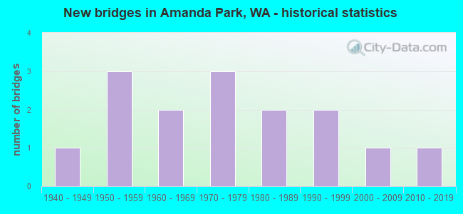
- New bridges - historical statistics
- 11940-1949
- 31950-1959
- 21960-1969
- 31970-1979
- 21980-1989
- 21990-1999
- 12000-2009
- 12010-2019

- Reconstructed bridges - Historical Statistics
- 11970-1979
- 21980-1989
- 01990-1999
- 12000-2009


- Bridge Condition - Deck
- 7.1%Very good
- 78.6%Good
- 14.3%Satisfactory

- Bridge Condition - Superstructure
- 7.1%Very good
- 78.6%Good
- 14.3%Satisfactory

- Bridge Condition - Substructure
- 78.6%Good
- 14.3%Satisfactory
- 7.1%Critical

- Bridge Condition - Channel
- 33.3%Very good
- 13.3%Good
- 40.0%Satisfactory
- 13.3%Poor
Find on map >> Show street view
Structure Number: 3255D, Location: 46.3 N JCT SR 109 (Lat: 47.473806, Lng: -124.022500), Route carried "on" structure: US 101, Year Built: 1947, Year Reconstructed: 1982, Status: Open, Structure Length: 2.13m (6.99ft), Average Daily Traffic: 1,314 (year 2019), Truck Traffic: 23%, Average Future Daily Traffic: 1,503 (year 2039), Design Load: HS 20, Features Intersected: BOULDER CREEK
Minimum Vertical Clearance: 30+ m (98+ ft), Kilometerpoint: 215.298, Lanes on structure: 2, Base Highway Network: Yes, Owner: State Highway Agency, Approaching Roadway Width: 11.0m (36.1ft), Material/Design: Concrete continuous, Design/Construction: Tee Beam, Number Of Spans In Main Unit: 3, Length of Maximum Span: 13.7m (44.9ft), Curb-To-Curb Width: 11.0m (36.1ft), Out-to-Out Width: 11.9m (39.0ft)
Condition: Deck: Good, Superstructure: Good, Substructure: Good, Channel: Very good, Operating Rating: 43.7 metric tons, Method Used To Determine Operating Rating: Load and Resistance Factor Rating (LRFR) rating reported by rating factor(RF) method using HL-93 loadings, Inventory Rating: 33.7 metric tons, Method Used To Determine Inventory Rating: Load and Resistance Factor Rating (LRFR) rating reported by rating factor(RF) method using HL-93 loadings, Structural Evaluation: Better than present minimum criteria, Deck Geometry: Equal to present minimum criteria, Waterway Adequacy: Equal to present desirable criteria, Approach Roadway Alignment: Equal to present desirable criteria, Length Of Structure Improvement: 2.13m (6.99ft), Designated Inspection Frequency: Every 48 months, Inspection Date: July 2019, Bridge Improvement Cost: $532,000, Roadway Improvement Cost: $106,000, Total Project Cost: $1,064,000 ( Estimate for 2014), Deck Structure Type: Concrete Cast-file-Place, Wearing Surface/Protective System: Wearing Surface: Bituminous, Membrane: Preformed Fabric
Find on map >> Show street view
Structure Number: 4740A, Location: 41.7 N JCT SR 109 (Lat: 47.476889, Lng: -123.929472), Route carried "on" structure: US 101, Year Built: 1954, Year Reconstructed: 1985, Status: Open, Structure Length: 3.11m (10.20ft), Average Daily Traffic: 1,587 (year 2019), Truck Traffic: 25%, Average Future Daily Traffic: 1,815 (year 2039), Design Load: HS 20, Features Intersected: PRAIRIE CR
Minimum Vertical Clearance: 30+ m (98+ ft), Kilometerpoint: 207.976, Lanes on structure: 2, Base Highway Network: Yes, Owner: State Highway Agency, Approaching Roadway Width: 11.3m (37.1ft), Material/Design: Concrete, Design/Construction: Tee Beam, Number Of Spans In Main Unit: 3, Length of Maximum Span: 21.3m (69.9ft), Curb-To-Curb Width: 11.1m (36.4ft), Out-to-Out Width: 12.0m (39.4ft)
Condition: Deck: Good, Superstructure: Good, Substructure: Good, Channel: Good, Operating Rating: 39.0 metric tons, Method Used To Determine Operating Rating: Load Factor (LF), Inventory Rating: 23.6 metric tons, Method Used To Determine Inventory Rating: Load Factor (LF), Structural Evaluation: Equal to present minimum criteria, Deck Geometry: Equal to present minimum criteria, Waterway Adequacy: Equal to present desirable criteria, Approach Roadway Alignment: Equal to present desirable criteria, Length Of Structure Improvement: 3.11m (10.20ft), Designated Inspection Frequency: Every 24 months, Inspection Date: July 2021, Bridge Improvement Cost: $796,000, Roadway Improvement Cost: $159,000, Total Project Cost: $1,591,000 ( Estimate for 2014), Deck Structure Type: Concrete Cast-file-Place, Wearing Surface/Protective System: Wearing Surface: Bituminous, Membrane: Preformed Fabric
Find on map >> Show street view
Structure Number: 5198A, Location: 43.2 N JCT SR 109 (Lat: 47.480000, Lng: -123.959167), Route carried "on" structure: US 101, Year Built: 1956, Year Reconstructed: 1985, Status: Open, Structure Length: 1.83m (6.00ft), Average Daily Traffic: 1,314 (year 2019), Truck Traffic: 23%, Average Future Daily Traffic: 1,503 (year 2039), Design Load: HS 20, Features Intersected: DRY CREEK
Minimum Vertical Clearance: 30+ m (98+ ft), Kilometerpoint: 210.406, Lanes on structure: 2, Base Highway Network: Yes, Owner: State Highway Agency, Approaching Roadway Width: 11.0m (36.1ft), Material/Design: Concrete continuous, Design/Construction: Slab, Number Of Spans In Main Unit: 3, Length of Maximum Span: 12.2m (40.0ft), Curb-To-Curb Width: 11.0m (36.1ft), Out-to-Out Width: 11.8m (38.7ft)
Condition: Deck: Good, Superstructure: Good, Substructure: Good, Channel: Satisfactory, Operating Rating: 38.6 metric tons, Method Used To Determine Operating Rating: Load and Resistance Factor Rating (LRFR) rating reported by rating factor(RF) method using HL-93 loadings, Inventory Rating: 29.8 metric tons, Method Used To Determine Inventory Rating: Load and Resistance Factor Rating (LRFR) rating reported by rating factor(RF) method using HL-93 loadings, Structural Evaluation: Better than present minimum criteria, Deck Geometry: Equal to present minimum criteria, Waterway Adequacy: Equal to present desirable criteria, Approach Roadway Alignment: Equal to present desirable criteria, Length Of Structure Improvement: 1.83m (6.00ft), Designated Inspection Frequency: Every 24 months, Inspection Date: July 2021, Bridge Improvement Cost: $456,000, Roadway Improvement Cost: $91,000, Total Project Cost: $912,000 ( Estimate for 2014), Deck Structure Type: Concrete Cast-file-Place, Wearing Surface/Protective System: Wearing Surface: Bituminous, Membrane: Preformed Fabric
Find on map >> Show street view
Structure Number: 5777A, Location: 45.1 N JCT SR 109 (Lat: 47.477167, Lng: -123.997139), Route carried "on" structure: US 101, Year Built: 1958, Status: Open, Structure Length: 2.47m (8.10ft), Average Daily Traffic: 1,314 (year 2019), Truck Traffic: 23%, Average Future Daily Traffic: 1,503 (year 2039), Design Load: HS 20, Features Intersected: TEN O'CLOCK CREEK
Minimum Vertical Clearance: 30+ m (98+ ft), Kilometerpoint: 213.351, Lanes on structure: 2, Base Highway Network: Yes, Owner: State Highway Agency, Approaching Roadway Width: 11.6m (38.1ft), Material/Design: Concrete continuous, Design/Construction: Slab, Number Of Spans In Main Unit: 3, Length of Maximum Span: 9.4m (30.8ft), Curb or Sidewalk Widths: Left: 0.3m (1.0ft), Right: 0.3m (1.0ft), Curb-To-Curb Width: 11.6m (38.1ft), Out-to-Out Width: 13.1m (43.0ft)
Condition: Deck: Good, Superstructure: Good, Substructure: Good, Channel: Satisfactory, Operating Rating: 37.9 metric tons, Method Used To Determine Operating Rating: Load and Resistance Factor Rating (LRFR) rating reported by rating factor(RF) method using HL-93 loadings, Inventory Rating: 29.2 metric tons, Method Used To Determine Inventory Rating: Load and Resistance Factor Rating (LRFR) rating reported by rating factor(RF) method using HL-93 loadings, Structural Evaluation: Better than present minimum criteria, Deck Geometry: Equal to present minimum criteria, Waterway Adequacy: Equal to present desirable criteria, Approach Roadway Alignment: Equal to present desirable criteria, Length Of Structure Improvement: 2.47m (8.10ft), Designated Inspection Frequency: Every 24 months, Inspection Date: July 2021, Bridge Improvement Cost: $648,000, Roadway Improvement Cost: $130,000, Total Project Cost: $1,296,000 ( Estimate for 2014), Deck Structure Type: Concrete Cast-file-Place, Wearing Surface/Protective System: Wearing Surface: Bituminous, Membrane: Preformed Fabric
Find on map >> Show street view
Structure Number: 6421A, Location: 39.1 N JCT SR 109 (Lat: 47.457631, Lng: -123.888992), Route carried "on" structure: US 101, Year Built: 1961, Status: Open, Structure Length: 12.13m (39.80ft), Average Daily Traffic: 2,271 (year 2019), Truck Traffic: 20%, Average Future Daily Traffic: 2,598 (year 2039), Design Load: HS 20, Features Intersected: QUINAULT RIVER
Minimum Vertical Clearance: 30+ m (98+ ft), Kilometerpoint: 203.775, Lanes on structure: 2, Base Highway Network: Yes, Owner: State Highway Agency, Approaching Roadway Width: 11.6m (38.1ft), Material/Design: Concrete continuous, Design/Construction: Box Beam or Girders - Multiple, Number Of Spans In Main Unit: 3, Number Of Approach Spans: 2, Length of Maximum Span: 33.5m (109.9ft), Curb or Sidewalk Widths: Left: 0.5m (1.6ft), Right: 1.5m (4.9ft), Curb-To-Curb Width: 7.9m (25.9ft), Out-to-Out Width: 10.5m (34.4ft)
Condition: Deck: Good, Superstructure: Good, Substructure: Satisfactory, Channel: Satisfactory, Operating Rating: 32.1 metric tons, Method Used To Determine Operating Rating: Load and Resistance Factor Rating (LRFR) rating reported by rating factor(RF) method using HL-93 loadings, Inventory Rating: 24.6 metric tons, Method Used To Determine Inventory Rating: Load and Resistance Factor Rating (LRFR) rating reported by rating factor(RF) method using HL-93 loadings, Structural Evaluation: Equal to present minimum criteria, Deck Geometry: High priority of corrective action, Waterway Adequacy: Equal to present desirable criteria, Approach Roadway Alignment: Equal to present desirable criteria, Length Of Structure Improvement: 12.13m (39.80ft), Designated Inspection Frequency: Every 24 months, Underwater Inspection Frequency: Every 60 months, Inspection Date: April 2021, Underwater Inspection Date: October 2020, Bridge Improvement Cost: $3,184,000, Roadway Improvement Cost: $637,000, Total Project Cost: $6,368,000 ( Estimate for 2014), Deck Structure Type: Concrete Cast-file-Place, Wearing Surface/Protective System: Wearing Surface: Bituminous, Membrane: Preformed Fabric
Find on map >> Show street view
Structure Number: 80996, Location: 5.0 NE JCT US 101 (Lat: 47.492422, Lng: -123.814611), Route carried "on" structure: County highway 93400, Year Built: 1983, Status: Open, Structure Length: 0.91m (2.99ft), Average Daily Traffic: 419 (year 2018), Truck Traffic: 5%, Average Future Daily Traffic: 527 (year 2038), Design Load: HS 20, Features Intersected: EWELL CREEK, Facility Carried by Structure: QUINAULT S SHORE
Minimum Vertical Clearance: 30+ m (98+ ft), Kilometerpoint: 0.001, Lanes on structure: 2, Owner: County Highway Agency, Approaching Roadway Width: 7.3m (24.0ft), Material/Design: Prestressed concrete, Design/Construction: Slab, Number Of Spans In Main Unit: 1, Length of Maximum Span: 9.1m (29.9ft), Curb-To-Curb Width: 8.7m (28.5ft), Out-to-Out Width: 9.2m (30.2ft)
Condition: Deck: Good, Superstructure: Good, Substructure: Good, Channel: Very good, Operating Rating: 70.7 metric tons, Method Used To Determine Operating Rating: Load Factor (LF), Inventory Rating: 40.8 metric tons, Method Used To Determine Inventory Rating: Load Factor (LF), Structural Evaluation: Better than present minimum criteria, Deck Geometry: Somewhat better than minimum adequacy, Waterway Adequacy: Equal to present desirable criteria, Approach Roadway Alignment: Equal to present desirable criteria, Designated Inspection Frequency: Every 24 months, Inspection Date: March 2020, Deck Structure Type: Concrete Precast Panels, Wearing Surface/Protective System: Wearing Surface: Bituminous
Find on map >> Show street view
Structure Number: 81053, Location: 0.2 S JCT 9340 (Lat: 47.490000, Lng: -123.812500), Route carried "on" structure: County highway 38350, Year Built: 1985, Status: Open, Structure Length: 2.07m (6.79ft), Average Daily Traffic: 85 (year 2020), Truck Traffic: 5%, Average Future Daily Traffic: 104 (year 2040), Design Load: HS 20, Features Intersected: ZIEGLER CREEK, Facility Carried by Structure: LISCUUM ROAD
Minimum Vertical Clearance: 30+ m (98+ ft), Kilometerpoint: 0.001, Lanes on structure: 2, Owner: County Highway Agency, Approaching Roadway Width: 7.3m (24.0ft), Material/Design: Prestressed concrete, Design/Construction: Slab, Number Of Spans In Main Unit: 3, Length of Maximum Span: 9.4m (30.8ft), Curb-To-Curb Width: 6.9m (22.6ft), Out-to-Out Width: 7.3m (24.0ft)
Condition: Deck: Good, Superstructure: Good, Substructure: Good, Channel: Very good, Operating Rating: 51.7 metric tons, Method Used To Determine Operating Rating: Load Factor (LF), Inventory Rating: 30.8 metric tons, Method Used To Determine Inventory Rating: Load Factor (LF), Structural Evaluation: Better than present minimum criteria, Deck Geometry: Somewhat better than minimum adequacy, Waterway Adequacy: Equal to present desirable criteria, Approach Roadway Alignment: Equal to present desirable criteria, Designated Inspection Frequency: Every 24 months, Inspection Date: March 2020, Deck Structure Type: Concrete Precast Panels, Wearing Surface/Protective System: Wearing Surface: Bituminous, Deck Protection: Epoxy Coated Reinforcing
Find on map >> Show street view
Structure Number: 8209, Location: 03.9 NE JCT US 101 (Lat: 47.481994, Lng: -123.823556), Route carried "on" structure: County highway 93400, Year Built: 1971, Status: Temporarily open, Structure Length: 4.30m (14.11ft), Average Daily Traffic: 477 (year 2019), Truck Traffic: 5%, Average Future Daily Traffic: 722 (year 2040), Design Load: HS 20, Features Intersected: ZIEGLER CREEK, Facility Carried by Structure: QUINAULT S SHORE
Minimum Vertical Clearance: 30+ m (98+ ft), Kilometerpoint: 0.001, Lanes on structure: 2, Owner: County Highway Agency, Approaching Roadway Width: 7.6m (24.9ft), Skew: 3 degrees, Material/Design: Prestressed concrete, Design/Construction: Slab, Number Of Spans In Main Unit: 5, Length of Maximum Span: 8.5m (27.9ft), Curb-To-Curb Width: 9.8m (32.2ft), Out-to-Out Width: 9.8m (32.2ft)
Condition: Deck: Satisfactory, Superstructure: Satisfactory, Substructure: Critical, Channel: Satisfactory, Structural Evaluation: High priority of replacement, Deck Geometry: Equal to present minimum criteria, Waterway Adequacy: Equal to present desirable criteria, Approach Roadway Alignment: Equal to present minimum criteria, Length Of Structure Improvement: 5.18m (16.99ft), Designated Inspection Frequency: Every 12 months, Inspection Date: March 2021, Bridge Improvement Cost: $4,472,000, Roadway Improvement Cost: $469,000, Total Project Cost: $5,492,000 ( Estimate for 2017), Deck Structure Type: Concrete Precast Panels, Wearing Surface/Protective System: Wearing Surface: Bituminous
Find on map >> Show street view
Structure Number: 82507, Location: 1.4 NE JCT US 101 (Lat: 47.460417, Lng: -123.861111), Route carried "on" structure: County highway 93400, Year Built: 1973, Status: Open, Structure Length: 4.42m (14.50ft), Average Daily Traffic: 1,845 (year 2018), Truck Traffic: 9%, Average Future Daily Traffic: 2,251 (year 2038), Design Load: HS 20, Features Intersected: WILLABY CREEK, Facility Carried by Structure: QUINAULT S SHORE
Minimum Vertical Clearance: 30+ m (98+ ft), Kilometerpoint: 0.001, Lanes on structure: 2, Owner: County Highway Agency, Approaching Roadway Width: 8.5m (27.9ft), Material/Design: Concrete continuous, Design/Construction: Box Beam or Girders - Multiple, Number Of Spans In Main Unit: 3, Length of Maximum Span: 28.0m (91.9ft), Curb or Sidewalk Widths: Left: 0.0m, Right: 0.9m (3.0ft), Curb-To-Curb Width: 7.9m (25.9ft), Out-to-Out Width: 9.1m (29.9ft)
Condition: Deck: Satisfactory, Superstructure: Satisfactory, Substructure: Good, Channel: Very good, Operating Rating: 89.8 metric tons, Method Used To Determine Operating Rating: Load Factor (LF), Inventory Rating: 57.1 metric tons, Method Used To Determine Inventory Rating: Load Factor (LF), Structural Evaluation: Equal to present minimum criteria, Deck Geometry: Meets minimum limits, Waterway Adequacy: Equal to present desirable criteria, Approach Roadway Alignment: Equal to present desirable criteria, Designated Inspection Frequency: Every 24 months, Inspection Date: March 2020, Deck Structure Type: Concrete Cast-file-Place, Wearing Surface/Protective System: Wearing Surface: Monolithic Concrete
Find on map >> Show street view
Structure Number: 82707, Location: 2.3 NE JCT US 101 (Lat: 47.468472, Lng: -123.845833), Route carried "on" structure: County highway 93400, Year Built: 1973, Status: Open, Structure Length: 1.98m (6.50ft), Average Daily Traffic: 962 (year 2020), Truck Traffic: 7%, Average Future Daily Traffic: 1,296 (year 2040), Design Load: HS 20, Features Intersected: FALLS CREEK, Facility Carried by Structure: QUINAULT S SHORE
Minimum Vertical Clearance: 30+ m (98+ ft), Kilometerpoint: 0.001, Lanes on structure: 2, Owner: County Highway Agency, Approaching Roadway Width: 7.3m (24.0ft), Material/Design: Prestressed concrete, Design/Construction: Slab, Number Of Spans In Main Unit: 3, Length of Maximum Span: 6.4m (21.0ft), Curb-To-Curb Width: 7.9m (25.9ft), Out-to-Out Width: 8.1m (26.6ft)
Condition: Deck: Good, Superstructure: Good, Substructure: Satisfactory, Channel: Good, Operating Rating: 75.3 metric tons, Method Used To Determine Operating Rating: Load Factor (LF), Inventory Rating: 45.4 metric tons, Method Used To Determine Inventory Rating: Load Factor (LF), Structural Evaluation: Equal to present minimum criteria, Deck Geometry: Somewhat better than minimum adequacy, Waterway Adequacy: Equal to present desirable criteria, Approach Roadway Alignment: Equal to present desirable criteria, Designated Inspection Frequency: Every 24 months, Inspection Date: March 2020, Deck Structure Type: Concrete Precast Panels, Wearing Surface/Protective System: Wearing Surface: Bituminous
Find on map >> Show street view
Structure Number: 8833, Location: 4.7 NE JCT SR101 (Lat: 47.490000, Lng: -123.817778), Route carried "on" structure: County highway 93400, Year Built: 1965, Year Reconstructed: 2009, Status: Open, Structure Length: 0.70m (2.30ft), Average Daily Traffic: 477 (year 2019), Truck Traffic: 5%, Average Future Daily Traffic: 722 (year 2040), Design Load: HS 25 or greater, Features Intersected: EWELL CREEK, Facility Carried by Structure: QUINAULT S SHORE
Minimum Vertical Clearance: 30+ m (98+ ft), Kilometerpoint: 0.001, Lanes on structure: 2, Owner: County Highway Agency, Approaching Roadway Width: 7.3m (24.0ft), Skew: 2 degrees, Material/Design: Steel, Design/Construction: Culvert, Number Of Spans In Main Unit: 3, Length of Maximum Span: 2.4m (7.9ft)
Condition: Channel: Satisfactory, Culverts: Satisfactory, Operating Rating: 40.8 metric tons, Method Used To Determine Operating Rating: Field evaluation and documented engineering judgment, Inventory Rating: 40.8 metric tons, Method Used To Determine Inventory Rating: Field evaluation and documented engineering judgment, Structural Evaluation: Equal to present minimum criteria, Waterway Adequacy: Equal to present desirable criteria, Approach Roadway Alignment: Equal to present desirable criteria, Designated Inspection Frequency: Every 24 months, Inspection Date: March 2021
Find on map >> Show street view
Structure Number: 88342, Location: 2.8 NE OF JCT SR 101 (Lat: 47.473056, Lng: -123.838056), Route carried "on" structure: County highway 93400, Year Built: 2011, Status: Open, Structure Length: 1.55m (5.09ft), Average Daily Traffic: 1,000 (year 2020), Truck Traffic: 7%, Average Future Daily Traffic: 1,220 (year 2040), Design Load: HL 93, Features Intersected: GATTON CREEK, Facility Carried by Structure: QUINAULT S SHORE
Minimum Vertical Clearance: 30+ m (98+ ft), Kilometerpoint: 0.001, Lanes on structure: 2, Owner: County Highway Agency, Approaching Roadway Width: 6.7m (22.0ft), Skew: 3 degrees, Material/Design: Prestressed concrete, Design/Construction: Stringer/Multi-beam, Number Of Spans In Main Unit: 1, Length of Maximum Span: 15.2m (49.9ft), Curb-To-Curb Width: 10.5m (34.4ft), Out-to-Out Width: 11.4m (37.4ft)
Condition: Deck: Very good, Superstructure: Very good, Substructure: Good, Channel: Very good, Operating Rating: 53.5 metric tons, Method Used To Determine Operating Rating: Load and Resistance Factor Rating (LRFR) rating reported by rating factor(RF) method using HL-93 loadings, Inventory Rating: 41.5 metric tons, Method Used To Determine Inventory Rating: Load and Resistance Factor Rating (LRFR) rating reported by rating factor(RF) method using HL-93 loadings, Structural Evaluation: Better than present minimum criteria, Deck Geometry: Equal to present minimum criteria, Waterway Adequacy: Equal to present desirable criteria, Approach Roadway Alignment: Equal to present desirable criteria, Designated Inspection Frequency: Every 24 months, Inspection Date: March 2021, Deck Structure Type: Other, Wearing Surface/Protective System: Wearing Surface: Bituminous, Membrane: Preformed Fabric, Deck Protection: Epoxy Coated Reinforcing
Find on map >> Show street view
Structure Number: 9500014P, Location: 4.9 MI. NE OF JCT. HWY. 1 (Lat: 47.503250, Lng: -123.835056), Route carried "on" structure: Federal lands road 104, Year Built: 1990, Status: Open, Structure Length: 2.13m (6.99ft), Average Daily Traffic: 436 (year 2011), Truck Traffic: 2%, Average Future Daily Traffic: 500 (year 2031), Design Load: HS 20, Features Intersected: CANOE CREEK, Facility Carried by Structure: NORTH SHORE ROAD
Minimum Vertical Clearance: 30+ m (98+ ft), Kilometerpoint: 7.854, Lanes on structure: 2, Owner: National Park Service, Approaching Roadway Width: 6.7m (22.0ft), Material/Design: Prestressed concrete, Design/Construction: Slab, Number Of Spans In Main Unit: 1, Length of Maximum Span: 21.3m (69.9ft), Curb-To-Curb Width: 6.9m (22.6ft), Out-to-Out Width: 7.9m (25.9ft)
Condition: Deck: Good, Superstructure: Good, Substructure: Good, Channel: Satisfactory, Operating Rating: 73.5 metric tons, Method Used To Determine Operating Rating: Load Factor (LF), Inventory Rating: 33.6 metric tons, Method Used To Determine Inventory Rating: Load Factor (LF), Structural Evaluation: Better than present minimum criteria, Deck Geometry: Meets minimum limits, Waterway Adequacy: Better than present minimum criteria, Approach Roadway Alignment: Equal to present desirable criteria, Designated Inspection Frequency: Every 24 months, Inspection Date: August 2021, Bridge Improvement Cost: $45,000, Roadway Improvement Cost: $5,000, Total Project Cost: $68,000, Deck Structure Type: Concrete Precast Panels, Wearing Surface/Protective System: Wearing Surface: Bituminous
Find on map >> Show street view
Structure Number: 9500017P, Location: 5.3 MI. NE OF JCT. HWY. 1 (Lat: 47.503222, Lng: -123.826194), Route carried "on" structure: Federal lands road 104, Year Built: 1990, Status: Open, Structure Length: 1.94m (6.36ft), Average Daily Traffic: 258 (year 2011), Truck Traffic: 2%, Average Future Daily Traffic: 310 (year 2031), Design Load: HS 20, Features Intersected: KESTNER CREEK, Facility Carried by Structure: NORTH SHORE ROAD
Minimum Vertical Clearance: 30+ m (98+ ft), Kilometerpoint: 8.530, Lanes on structure: 2, Owner: National Park Service, Approaching Roadway Width: 7.3m (24.0ft), Material/Design: Prestressed concrete, Design/Construction: Slab, Number Of Spans In Main Unit: 1, Length of Maximum Span: 19.4m (63.6ft), Curb-To-Curb Width: 6.9m (22.6ft), Out-to-Out Width: 7.9m (25.9ft)
Condition: Deck: Good, Superstructure: Good, Substructure: Good, Channel: Poor, Operating Rating: 74.4 metric tons, Method Used To Determine Operating Rating: Load Factor (LF), Inventory Rating: 37.2 metric tons, Method Used To Determine Inventory Rating: Load Factor (LF), Structural Evaluation: Better than present minimum criteria, Deck Geometry: Meets minimum limits, Waterway Adequacy: Somewhat better than minimum adequacy, Approach Roadway Alignment: Equal to present desirable criteria, Designated Inspection Frequency: Every 24 months, Inspection Date: August 2021, Bridge Improvement Cost: $100,000, Roadway Improvement Cost: $10,000, Total Project Cost: $150,000, Deck Structure Type: Concrete Precast Panels, Wearing Surface/Protective System: Wearing Surface: Bituminous
Find on map >> Show street view
Structure Number: 9500048P, Location: 2.1 MI. NE OF JCT. HWY. 1 (Lat: 47.481500, Lng: -123.889278), Route carried "on" structure: Federal lands road 104, Year Built: 2005, Status: Open, Structure Length: 3.48m (11.42ft), Average Daily Traffic: 436 (year 2011), Average Future Daily Traffic: 500 (year 2031), Design Load: HS 20, Features Intersected: GRANDEY CREEK, Facility Carried by Structure: NORTH SHORE ROAD
Minimum Vertical Clearance: 30+ m (98+ ft), Kilometerpoint: 3.380, Lanes on structure: 2, Owner: National Park Service, Approaching Roadway Width: 7.9m (25.9ft), Material/Design: Prestressed concrete, Design/Construction: Tee Beam, Number Of Spans In Main Unit: 1, Length of Maximum Span: 33.3m (109.3ft), Curb-To-Curb Width: 8.0m (26.2ft), Out-to-Out Width: 9.0m (29.5ft)
Condition: Deck: Good, Superstructure: Good, Substructure: Good, Channel: Poor, Operating Rating: 74.4 metric tons, Method Used To Determine Operating Rating: Load Factor (LF), Inventory Rating: 41.7 metric tons, Method Used To Determine Inventory Rating: Load Factor (LF), Structural Evaluation: Better than present minimum criteria, Deck Geometry: Somewhat better than minimum adequacy, Waterway Adequacy: Equal to present desirable criteria, Approach Roadway Alignment: Equal to present minimum criteria, Designated Inspection Frequency: Every 24 months, Inspection Date: August 2021, Wearing Surface/Protective System: Wearing Surface: Bituminous, Membrane: Preformed Fabric