Bridge Statistics for Ambridge, Pennsylvania (PA)
Condition, Traffic, Stress, Structural Evaluation, Project Costs
- National Bridge Inventory (NBI) Statistics
- 13Number of bridges
- 112ft / 33.8mTotal length
- $2,987,000Total costs
- 90,425Total average daily traffic
- 6,244Total average daily truck traffic
- National Bridge Inventory (NBI) Registered Bridges for Ambridge
- No street view available for this location
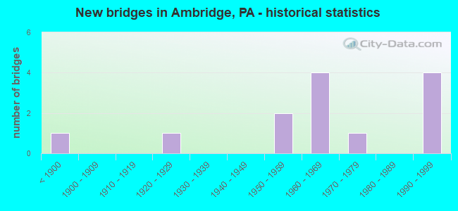
- New bridges - historical statistics
- 1Before 1900
- 11920-1929
- 21950-1959
- 41960-1969
- 11970-1979
- 41990-1999

- Reconstructed bridges - Historical Statistics
- 11970-1979
- 11980-1989
- 11990-1999
- 02000-2009
- 12010-2019


- Bridge Condition - Deck
- 80.0%Satisfactory
- 20.0%Poor

- Bridge Condition - Superstructure
- 33.3%Good
- 50.0%Satisfactory
- 16.7%Poor

- Bridge Condition - Substructure
- 66.7%Satisfactory
- 33.3%Fair

- Bridge Condition - Channel
- 33.3%Very good
- 66.7%Fair
Find on map >> Show street view
Structure Number: 3538, Location: @ MERCHANT ST. EXTENTION (Lat: 40.602153, Lng: -80.232058), Route carried "on" structure: State highway 65, Year Built: 1960, Year Reconstructed: 2010, Status: Open, Structure Length: 7.86m (25.79ft), Average Daily Traffic: 20,456 (year 2022), Truck Traffic: 7%, Average Future Daily Traffic: 27,182 (year 2032), Design Load: HS 20, Features Intersected: FRENCH POINT CREEK, Facility Carried by Structure: OHIO RIVER BL
Minimum Vertical Clearance: 30+ m (98+ ft), Kilometerpoint: 2.932, Lanes on structure: 5, Lanes under structure: 2, Base Highway Network: Yes, Owner: State Highway Agency, Approaching Roadway Width: 21.3m (69.9ft), Skew: 30 degrees, Material/Design: Steel, Design/Construction: Stringer/Multi-beam, Number Of Spans In Main Unit: 1, Number Of Approach Spans: 3, Length of Maximum Span: 30.5m (100.1ft), Curb or Sidewalk Widths: Left: 0.2m (0.7ft), Right: 0.2m (0.7ft), Curb-To-Curb Width: 20.4m (66.9ft), Out-to-Out Width: 21.5m (70.5ft)
Condition: Deck: Satisfactory, Superstructure: Satisfactory, Substructure: Satisfactory, Channel: Very good, Operating Rating: 59.0 metric tons, Method Used To Determine Operating Rating: Load Factor (LF), Inventory Rating: 35.4 metric tons, Method Used To Determine Inventory Rating: Load Factor (LF), Structural Evaluation: Equal to present minimum criteria, Deck Geometry: Somewhat better than minimum adequacy, Underclear: Better than present minimum criteria, Waterway Adequacy: Superior to present desirable criteria, Approach Roadway Alignment: Equal to present minimum criteria, Length Of Structure Improvement: 7.90m (25.92ft), Designated Inspection Frequency: Every 24 months, Inspection Date: October 2020, Bridge Improvement Cost: $217,000, Roadway Improvement Cost: $640,000, Total Project Cost: $2,933,000, Deck Structure Type: Concrete Cast-file-Place, Wearing Surface/Protective System: Wearing Surface: Epoxy Overlay, Deck Protection: Epoxy Coated Reinforcing
Find on map >> Show street view
Structure Number: 3842, Location: 102001 BIG SEWICK CK BRDG (Lat: 40.581203, Lng: -80.216436), Route carried "on" structure: City street , Year Built: 1978, Status: Posted for load, Structure Length: 2.04m (6.69ft), Average Daily Traffic: 150 (year 2018), Truck Traffic: 7%, Average Future Daily Traffic: 158 (year 2040), Design Load: HS 20, Features Intersected: BIG SEWICKLEY CREEK, Facility Carried by Structure: VALLEY RD
Minimum Vertical Clearance: 30+ m (98+ ft), Kilometerpoint: 0.000, Lanes on structure: 2, Owner: Town or Township Highway Agency, Approaching Roadway Width: 7.9m (25.9ft), Skew: 1 degrees, Material/Design: Prestressed concrete, Design/Construction: Box Beam or Girders - Multiple, Number Of Spans In Main Unit: 1, Length of Maximum Span: 20.1m (65.9ft), Curb-To-Curb Width: 7.9m (25.9ft), Out-to-Out Width: 8.7m (28.5ft)
Condition: Deck: Poor, Superstructure: Poor, Substructure: Satisfactory, Channel: Fair, Operating Rating: 37.2 metric tons, Method Used To Determine Operating Rating: Load Factor (LF), Inventory Rating: 15.4 metric tons, Method Used To Determine Inventory Rating: Load Factor (LF), Structural Evaluation: Meets minimum limits, Deck Geometry: Somewhat better than minimum adequacy, Waterway Adequacy: Equal to present desirable criteria, Approach Roadway Alignment: Equal to present desirable criteria, Bridge Posting: Required (Relationship of Operating Rating to Maximum Legal Load: 0.1 - 9.9% below), Length Of Structure Improvement: 2.00m (6.56ft), Designated Inspection Frequency: Every 24 months, Other Special Inspection Frequency: Every 12 months, Inspection Date: May 2020, Other Special Inspection Date: May 2021, Bridge Improvement Cost: $4,000, Roadway Improvement Cost: $27,000, Total Project Cost: $54,000, Deck Structure Type: Other, Wearing Surface/Protective System: Wearing Surface: Bituminous
Find on map >> Show street view
Structure Number: 3893, Location: 402001 AMBR-LEETSDALELINE (Lat: 40.579644, Lng: -80.220772), Route carried "on" structure: City street , Year Built: 1827, Year Reconstructed: 2004, Status: Open, Structure Length: 1.13m (3.71ft), Average Daily Traffic: 2,000 (year 2019), Truck Traffic: 5%, Average Future Daily Traffic: 2,100 (year 2041), Features Intersected: BIG SEWICKLEY CREEK, Facility Carried by Structure: MERCHANT ST
Minimum Vertical Clearance: 30+ m (98+ ft), Kilometerpoint: 0.000, Lanes on structure: 2, Owner: City or Municipal Highway Agency, Approaching Roadway Width: 11.0m (36.1ft), Material/Design: Masonry, Design/Construction: Arch - Deck, Number Of Spans In Main Unit: 1, Length of Maximum Span: 11.3m (37.1ft), Curb or Sidewalk Widths: Left: 1.5m (4.9ft), Right: 1.5m (4.9ft), Curb-To-Curb Width: 11.0m (36.1ft), Out-to-Out Width: 15.2m (49.9ft)
Condition: Superstructure: Satisfactory, Substructure: Fair, Channel: Fair, Operating Rating: 49.0 metric tons, Method Used To Determine Operating Rating: Field evaluation and documented engineering judgment, Inventory Rating: 32.7 metric tons, Method Used To Determine Inventory Rating: Field evaluation and documented engineering judgment, Structural Evaluation: Somewhat better than minimum adequacy, Deck Geometry: Equal to present minimum criteria, Waterway Adequacy: Superior to present desirable criteria, Approach Roadway Alignment: Equal to present desirable criteria, Length Of Structure Improvement: 1.10m (3.61ft), Designated Inspection Frequency: Every 24 months, Inspection Date: March 2021
Find on map >> Show street view
Structure Number: 3895, Location: 004059 .5M S/SR 0065&0989 (Lat: 40.580961, Lng: -80.226989), Route carried "on" structure: Ramp Other road , Year Built: 1990, Status: Open, Structure Length: 19.96m (65.49ft), Average Daily Traffic: 350 (year 2019), Truck Traffic: 20%, Average Future Daily Traffic: 400 (year 2041), Design Load: HS 25 or greater, Features Intersected: SR 0065,& NORFOLK SOUTHE, Facility Carried by Structure: RNR-ACCESS RD
Minimum Vertical Clearance: 30+ m (98+ ft), Kilometerpoint: 0.000, Lanes on structure: 2, Lanes under structure: 6, Owner: County Highway Agency, Approaching Roadway Width: 9.8m (32.2ft), Material/Design: Steel continuous, Design/Construction: Stringer/Multi-beam, Number Of Spans In Main Unit: 5, Length of Maximum Span: 41.5m (136.2ft), Curb or Sidewalk Widths: Left: 0.2m (0.7ft), Right: 1.8m (5.9ft), Curb-To-Curb Width: 9.8m (32.2ft), Out-to-Out Width: 12.3m (40.4ft)
Condition: Deck: Satisfactory, Superstructure: Good, Substructure: Satisfactory, Operating Rating: 70.8 metric tons, Method Used To Determine Operating Rating: Load Factor (LF), Inventory Rating: 42.6 metric tons, Method Used To Determine Inventory Rating: Load Factor (LF), Structural Evaluation: Equal to present minimum criteria, Deck Geometry: Equal to present minimum criteria, Underclear: Equal to present minimum criteria, Approach Roadway Alignment: Somewhat better than minimum adequacy, Length Of Structure Improvement: 20.00m (65.62ft), Designated Inspection Frequency: Every 24 months, Inspection Date: June 2021, Deck Structure Type: Concrete Cast-file-Place, Wearing Surface/Protective System: Wearing Surface: Monolithic Concrete, Deck Protection: Epoxy Coated Reinforcing
Find on map >> Show street view
Structure Number: 46218, Location: AMBRIDGE SIDE (Lat: 40.592481, Lng: -80.233503), Route carried "on" structure: State highway , Year Built: 1960, Year Reconstructed: 1985, Status: Open, Structure Length: 1.40m (4.59ft), Average Daily Traffic: 11,401 (year 2022), Truck Traffic: 7%, Average Future Daily Traffic: 14,588 (year 2032), Design Load: HS 20, Features Intersected: ROUTE 65, Facility Carried by Structure: AMB- ALIQU BRIDGE
Minimum Vertical Clearance: 30+ m (98+ ft), Kilometerpoint: 0.014, Lanes on structure: 2, Lanes under structure: 2, Owner: State Highway Agency, Approaching Roadway Width: 10.1m (33.1ft), Skew: 30 degrees, Material/Design: Steel, Design/Construction: Stringer/Multi-beam, Number Of Spans In Main Unit: 1, Length of Maximum Span: 13.1m (43.0ft), Curb or Sidewalk Widths: Left: 1.5m (4.9ft), Right: 0.2m (0.7ft), Curb-To-Curb Width: 8.5m (27.9ft), Out-to-Out Width: 9.0m (29.5ft)
Condition: Deck: Satisfactory, Superstructure: Good, Substructure: Satisfactory, Operating Rating: 53.5 metric tons, Method Used To Determine Operating Rating: Load Factor (LF), Inventory Rating: 31.8 metric tons, Method Used To Determine Inventory Rating: Load Factor (LF), Structural Evaluation: Equal to present minimum criteria, Deck Geometry: High priority of replacement, Underclear: High priority of corrective action, Approach Roadway Alignment: Equal to present desirable criteria, Designated Inspection Frequency: Every 24 months, Inspection Date: April 2021, Deck Structure Type: Concrete Cast-file-Place, Wearing Surface/Protective System: Wearing Surface: Monolithic Concrete
Find on map >> Show street view
Structure Number: 46219, Location: ALIQUIPPA SIDE (Lat: 40.591667, Lng: -80.236667), Route carried "on" structure: State highway , Year Built: 1958, Year Reconstructed: 1984, Status: Open, Structure Length: 1.37m (4.49ft), Average Daily Traffic: 11,401 (year 2022), Truck Traffic: 7%, Average Future Daily Traffic: 14,588 (year 2032), Design Load: HS 20, Features Intersected: ROUTE 51, Facility Carried by Structure: AMB-ALIQUIP BRIDG
Minimum Vertical Clearance: 6.37m (20.90ft), Kilometerpoint: 0.000, Lanes on structure: 2, Lanes under structure: 2, Owner: State Highway Agency, Approaching Roadway Width: 8.2m (26.9ft), Material/Design: Steel, Design/Construction: Stringer/Multi-beam, Number Of Spans In Main Unit: 1, Length of Maximum Span: 12.5m (41.0ft), Curb or Sidewalk Widths: Left: 0.9m (3.0ft), Right: 0.2m (0.7ft), Curb-To-Curb Width: 8.2m (26.9ft), Out-to-Out Width: 11.9m (39.0ft)
Condition: Deck: Satisfactory, Superstructure: Satisfactory, Substructure: Fair, Operating Rating: 60.8 metric tons, Method Used To Determine Operating Rating: Load Factor (LF), Inventory Rating: 40.8 metric tons, Method Used To Determine Inventory Rating: Load Factor (LF), Structural Evaluation: Somewhat better than minimum adequacy, Deck Geometry: High priority of replacement, Underclear: High priority of corrective action, Approach Roadway Alignment: Equal to present desirable criteria, Designated Inspection Frequency: Every 24 months, Inspection Date: April 2021, Deck Structure Type: Concrete Cast-file-Place, Wearing Surface/Protective System: Wearing Surface: Monolithic Concrete
Find on map >> Show street view
Structure Number: 3538, Location: @ MERCHANT ST. EXTENTION (Lat: 40.602153, Lng: -80.232058), Route carried "under" structure: City street , Year Built: 1960, Structure Length: 0. m, Average Daily Traffic: 25 (year 1993), Truck Traffic: 1%, Features Intersected: FRENCH POINT CREEK, Facility Carried by Structure: OHIO RIVER BL
Minimum Vertical Clearance: 4.98m (16.34ft), Kilometerpoint: 0.000, Lanes on structure: 5, Lanes under structure: 2, Material/Design: Steel, Design/Construction: Stringer/Multi-beam, Length of Maximum Span: 30.5m (100.1ft)
Find on map >> Show street view
Structure Number: 3894, Location: AMBRIDGE-ALIQUIPPA SP 2-9 (Lat: 40.592317, Lng: -80.237189), Route carried "under" structure: State highway 65, Year Built: 1927, Structure Length: 0. m, Average Daily Traffic: 10,150 (year 2022), Truck Traffic: 7%, Features Intersected: OHIO RIVER, 2 RR, Facility Carried by Structure: AMBRIDGE-ALIQ BR
Minimum Vertical Clearance: 5.21m (17.09ft), Kilometerpoint: 1.423, Lanes on structure: 2, Lanes under structure: 2, Material/Design: Steel continuous, Design/Construction: Truss - Thru, Length of Maximum Span: 161.5m (529.9ft)
Find on map >> Show street view
Structure Number: 3895, Location: 004059 .5M S/SR 0065&0989 (Lat: 40.580961, Lng: -80.226989), Route carried "under" structure: State highway 65, Year Built: 1990, Structure Length: 0. m, Average Daily Traffic: 9,739 (year 2021), Truck Traffic: 6%, Features Intersected: SR 0065,& NORFOLK SOUTHE, Facility Carried by Structure: RNR-ACCESS RD
Minimum Vertical Clearance: 7.99m (26.21ft), Kilometerpoint: 0.000, Lanes on structure: 2, Lanes under structure: 2, Material/Design: Steel continuous, Design/Construction: Stringer/Multi-beam, Length of Maximum Span: 41.5m (136.2ft)
Find on map >> Show street view
Structure Number: 3895, Location: 004059 .5M S/SR 0065&0989 (Lat: 40.580961, Lng: -80.226989), Route carried "under" structure: State highway 65, Year Built: 1990, Structure Length: 0. m, Average Daily Traffic: 8,887 (year 2021), Truck Traffic: 7%, Features Intersected: SR 0065,& NORFOLK SOUTHE, Facility Carried by Structure: RNR-ACCESS RD
Minimum Vertical Clearance: 7.96m (26.12ft), Kilometerpoint: 0.000, Lanes on structure: 2, Lanes under structure: 2, Material/Design: Steel continuous, Design/Construction: Stringer/Multi-beam, Length of Maximum Span: 41.5m (136.2ft)
Find on map >> Show street view
Structure Number: 3895, Location: 004059 .5M S/SR 0065&0989 (Lat: 40.580961, Lng: -80.226989), Route carried "under" structure: ServiceOther road , Year Built: 1990, Structure Length: 0. m, Average Daily Traffic: 50 (year 2019), Truck Traffic: 30%, Features Intersected: SR 0065,& NORFOLK SOUTHE, Facility Carried by Structure: RNR-ACCESS RD
Minimum Vertical Clearance: 6.81m (22.34ft), Kilometerpoint: 0.000, Lanes on structure: 2, Lanes under structure: 2, Material/Design: Steel continuous, Design/Construction: Stringer/Multi-beam, Length of Maximum Span: 41.5m (136.2ft)
Find on map >> Show street view
Structure Number: 46218, Location: AMBRIDGE SIDE (Lat: 40.592481, Lng: -80.233503), Route carried "under" structure: State highway 65, Year Built: 1960, Structure Length: 0. m, Average Daily Traffic: 10,306 (year 2022), Truck Traffic: 7%, Features Intersected: ROUTE 65, Facility Carried by Structure: AMB- ALIQU BRIDGE
Minimum Vertical Clearance: 4.44m (14.57ft), Kilometerpoint: 1.415, Lanes on structure: 2, Lanes under structure: 2, Material/Design: Steel, Design/Construction: Stringer/Multi-beam, Length of Maximum Span: 13.1m (43.0ft)
Find on map >> Show street view
Structure Number: 46219, Location: ALIQUIPPA SIDE (Lat: 40.591667, Lng: -80.236667), Route carried "under" structure: State highway 51, Year Built: 1958, Structure Length: 0. m, Average Daily Traffic: 5,510 (year 2022), Truck Traffic: 7%, Features Intersected: ROUTE 51, Facility Carried by Structure: AMB-ALIQUIP BRIDG
Minimum Vertical Clearance: 6.27m (20.57ft), Kilometerpoint: 1.931, Lanes on structure: 2, Lanes under structure: 2, Material/Design: Steel, Design/Construction: Stringer/Multi-beam, Length of Maximum Span: 12.5m (41.0ft)