Bridge Statistics for Andover, New York (NY)
Condition, Traffic, Stress, Structural Evaluation, Project Costs
- National Bridge Inventory (NBI) Statistics
- 26Number of bridges
- 151ft / 46.0mTotal length
- $27,224,000Total costs
- 22,582Total average daily traffic
- 1,601Total average daily truck traffic
- 24,289Total future (year 2038) average daily traffic
- National Bridge Inventory (NBI) Registered Bridges for Andover
- No street view available for this location
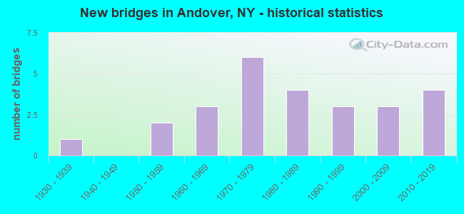
- New bridges - historical statistics
- 11930-1939
- 21950-1959
- 31960-1969
- 61970-1979
- 41980-1989
- 31990-1999
- 32000-2009
- 42010-2019

- Reconstructed bridges - Historical Statistics
- 21970-1979
- 11980-1989
- 31990-1999
- 02000-2009
- 12010-2019


- Bridge Condition - Deck
- 9.1%Excellent
- 36.4%Very good
- 22.7%Good
- 27.3%Satisfactory
- 4.5%Fair

- Bridge Condition - Superstructure
- 8.7%Excellent
- 26.1%Very good
- 43.5%Good
- 13.0%Satisfactory
- 4.3%Fair
- 4.3%Poor

- Bridge Condition - Substructure
- 21.7%Very good
- 26.1%Good
- 26.1%Satisfactory
- 26.1%Fair

- Bridge Condition - Channel
- 3.8%Very good
- 11.5%Good
- 38.5%Satisfactory
- 38.5%Fair
- 7.7%Poor

- Bridge Condition - Culverts
- 33.3%Good
- 33.3%Satisfactory
- 33.3%Fair
Find on map >> Show street view
Structure Number: 101251, Location: 0.2 MI SW OF ELM VALLEY (Lat: 42.151358, Lng: -77.862281), Route carried "on" structure: State highway 417, Year Built: 2014, Status: Open, Structure Length: 2.07m (6.79ft), Average Daily Traffic: 4,337 (year 2018), Truck Traffic: 8%, Average Future Daily Traffic: 4,363 (year 2040), Design Load: HL 93, Features Intersected: ELM VALLEY CREEK
Minimum Vertical Clearance: 30+ m (98+ ft), Kilometerpoint: 45.615, Lanes on structure: 2, Base Highway Network: Yes, Owner: State Highway Agency, Approaching Roadway Width: 11.0m (36.1ft), Material/Design: Prestressed concrete, Design/Construction: Tee Beam, Number Of Spans In Main Unit: 1, Length of Maximum Span: 20.1m (65.9ft), Curb-To-Curb Width: 11.0m (36.1ft), Out-to-Out Width: 12.0m (39.4ft)
Condition: Deck: Very good, Superstructure: Very good, Substructure: Very good, Channel: Satisfactory, Operating Rating: 97.1 metric tons, Method Used To Determine Operating Rating: Load Factor (LF), Inventory Rating: 53.5 metric tons, Method Used To Determine Inventory Rating: Load Factor (LF), Structural Evaluation: Equal to present desirable criteria, Deck Geometry: Somewhat better than minimum adequacy, Waterway Adequacy: Equal to present desirable criteria, Approach Roadway Alignment: Equal to present desirable criteria, Length Of Structure Improvement: 2.07m (6.79ft), Designated Inspection Frequency: Every 24 months, Inspection Date: November 2020, Bridge Improvement Cost: $623,000, Roadway Improvement Cost: $365,000, Total Project Cost: $988,000 ( Estimate for 2021), Wearing Surface/Protective System: Wearing Surface: Bituminous, Membrane: Other
Find on map >> Show street view
Structure Number: 101252, Location: 1.4 MI W OF ANDOVER (Lat: 42.149414, Lng: -77.820697), Route carried "on" structure: State highway 417, Year Built: 1994, Status: Open, Structure Length: 11.19m (36.71ft), Average Daily Traffic: 2,701 (year 2020), Truck Traffic: 8%, Average Future Daily Traffic: 2,717 (year 2040), Design Load: HS 25 or greater, Features Intersected: WNY & Pa RR, Dyke Creek
Minimum Vertical Clearance: 30+ m (98+ ft), Kilometerpoint: 49.058, Lanes on structure: 2, Base Highway Network: Yes, Owner: State Highway Agency, Approaching Roadway Width: 11.0m (36.1ft), Material/Design: Steel continuous, Design/Construction: Stringer/Multi-beam, Number Of Spans In Main Unit: 3, Length of Maximum Span: 47.2m (154.9ft), Curb-To-Curb Width: 10.8m (35.4ft), Out-to-Out Width: 11.8m (38.7ft)
Condition: Deck: Satisfactory, Superstructure: Good, Substructure: Satisfactory, Channel: Good, Operating Rating: 76.2 metric tons, Method Used To Determine Operating Rating: Load Factor (LF), Inventory Rating: 45.4 metric tons, Method Used To Determine Inventory Rating: Load Factor (LF), Structural Evaluation: Equal to present minimum criteria, Deck Geometry: Somewhat better than minimum adequacy, Underclear: Equal to present minimum criteria, Waterway Adequacy: Somewhat better than minimum adequacy, Approach Roadway Alignment: Equal to present desirable criteria, Length Of Structure Improvement: 11.18m (36.68ft), Designated Inspection Frequency: Every 24 months, Inspection Date: July 2020, Bridge Improvement Cost: $3,314,000, Roadway Improvement Cost: $1,941,000, Total Project Cost: $5,254,000 ( Estimate for 2021), Deck Structure Type: Concrete Cast-file-Place, Wearing Surface/Protective System: Wearing Surface: Integral Concrete, Deck Protection: Epoxy Coated Reinforcing
Find on map >> Show street view
Structure Number: 101253, Location: 1.5 MILES SE OF ANDOVER (Lat: 42.150861, Lng: -77.767486), Route carried "on" structure: State highway 417, Year Built: 2010, Status: Open, Structure Length: 1.86m (6.10ft), Average Daily Traffic: 1,346 (year 2018), Truck Traffic: 8%, Average Future Daily Traffic: 1,354 (year 2040), Design Load: HL 93, Features Intersected: DYKE CREEK
Minimum Vertical Clearance: 30+ m (98+ ft), Kilometerpoint: 53.757, Lanes on structure: 2, Base Highway Network: Yes, Owner: State Highway Agency, Approaching Roadway Width: 9.1m (29.9ft), Skew: 3 degrees, Material/Design: Prestressed concrete, Design/Construction: Box Beam or Girders - Single/Spread, Number Of Spans In Main Unit: 1, Length of Maximum Span: 17.6m (57.7ft), Curb-To-Curb Width: 9.1m (29.9ft), Out-to-Out Width: 10.4m (34.1ft)
Condition: Deck: Good, Superstructure: Good, Substructure: Good, Channel: Good, Operating Rating: 79.3 metric tons, Method Used To Determine Operating Rating: Load Factor (LF), Inventory Rating: 47.5 metric tons, Method Used To Determine Inventory Rating: Load Factor (LF), Structural Evaluation: Better than present minimum criteria, Deck Geometry: Somewhat better than minimum adequacy, Waterway Adequacy: Equal to present minimum criteria, Approach Roadway Alignment: Equal to present desirable criteria, Length Of Structure Improvement: 1.85m (6.07ft), Designated Inspection Frequency: Every 24 months, Inspection Date: October 2020, Bridge Improvement Cost: $708,000, Roadway Improvement Cost: $415,000, Total Project Cost: $1,122,000 ( Estimate for 2021), Deck Structure Type: Concrete Cast-file-Place, Wearing Surface/Protective System: Wearing Surface: Integral Concrete, Deck Protection: Epoxy Coated Reinforcing
Find on map >> Show street view
Structure Number: 101625, Location: .1 MI N JCT SR417 & SR 21 (Lat: 42.155056, Lng: -77.795203), Route carried "on" structure: State highway 21, Year Built: 2013, Status: Open, Structure Length: 2.35m (7.71ft), Average Daily Traffic: 1,991 (year 2017), Truck Traffic: 10%, Average Future Daily Traffic: 2,003 (year 2040), Design Load: HL 93, Features Intersected: DYKE CREEK
Minimum Vertical Clearance: 30+ m (98+ ft), Kilometerpoint: 0.064, Lanes on structure: 2, Base Highway Network: Yes, Owner: State Highway Agency, Approaching Roadway Width: 9.8m (32.2ft), Material/Design: Prestressed concrete, Design/Construction: Tee Beam, Number Of Spans In Main Unit: 1, Length of Maximum Span: 21.9m (71.9ft), Curb or Sidewalk Widths: Left: 1.7m (5.6ft), Right: 1.7m (5.6ft), Curb-To-Curb Width: 9.8m (32.2ft), Out-to-Out Width: 13.7m (44.9ft)
Condition: Deck: Good, Superstructure: Good, Substructure: Very good, Channel: Satisfactory, Operating Rating: 83.9 metric tons, Method Used To Determine Operating Rating: Load and Resistance Factor Rating (LRFR) rating reported by rating factor(RF) method using HL-93 loadings, Inventory Rating: 58.6 metric tons, Method Used To Determine Inventory Rating: Load and Resistance Factor Rating (LRFR) rating reported by rating factor(RF) method using HL-93 loadings, Structural Evaluation: Better than present minimum criteria, Deck Geometry: Somewhat better than minimum adequacy, Waterway Adequacy: Somewhat better than minimum adequacy, Approach Roadway Alignment: Equal to present desirable criteria, Length Of Structure Improvement: 2.34m (7.68ft), Designated Inspection Frequency: Every 24 months, Inspection Date: November 2021, Bridge Improvement Cost: $1,068,000, Roadway Improvement Cost: $626,000, Total Project Cost: $1,694,000 ( Estimate for 2021), Wearing Surface/Protective System: Wearing Surface: Epoxy Overlay
Find on map >> Show street view
Structure Number: 101626, Location: 0.5 MI N JCT RTS 417 + 21 (Lat: 42.161411, Lng: -77.792108), Route carried "on" structure: State highway 21, Year Built: 1960, Status: Open, Structure Length: 1.77m (5.81ft), Average Daily Traffic: 1,991 (year 2017), Truck Traffic: 10%, Average Future Daily Traffic: 2,003 (year 2040), Design Load: HS 20, Features Intersected: EAST VALLEY CREEK
Minimum Vertical Clearance: 30+ m (98+ ft), Kilometerpoint: 0.853, Lanes on structure: 2, Base Highway Network: Yes, Owner: State Highway Agency, Approaching Roadway Width: 11.0m (36.1ft), Skew: 5 degrees, Material/Design: Concrete, Design/Construction: Culvert, Number Of Spans In Main Unit: 2, Length of Maximum Span: 7.6m (24.9ft), Curb or Sidewalk Widths: Left: 0.0m, Right: 1.2m (3.9ft)
Condition: Channel: Fair, Culverts: Satisfactory, Operating Rating: 89.8 metric tons, Method Used To Determine Operating Rating: Load Factor (LF), Inventory Rating: 68.0 metric tons, Method Used To Determine Inventory Rating: Load Factor (LF), Structural Evaluation: Equal to present minimum criteria, Waterway Adequacy: Somewhat better than minimum adequacy, Approach Roadway Alignment: Equal to present desirable criteria, Length Of Structure Improvement: 1.76m (5.77ft), Designated Inspection Frequency: Every 24 months, Inspection Date: April 2020, Bridge Improvement Cost: $802,000, Roadway Improvement Cost: $470,000, Total Project Cost: $1,272,000 ( Estimate for 2021), Wearing Surface/Protective System: Wearing Surface: Bituminous
Find on map >> Show street view
Structure Number: 101627, Location: 3.0 MI N JCT 417 & 21 (Lat: 42.196644, Lng: -77.793478), Route carried "on" structure: State highway 21, Year Built: 1986, Status: Open, Structure Length: 0.98m (3.22ft), Average Daily Traffic: 1,991 (year 2017), Truck Traffic: 10%, Average Future Daily Traffic: 2,003 (year 2040), Design Load: HS 20+Mod, Features Intersected: RAILROAD BROOK
Minimum Vertical Clearance: 30+ m (98+ ft), Kilometerpoint: 4.843, Lanes on structure: 2, Base Highway Network: Yes, Owner: State Highway Agency, Approaching Roadway Width: 10.4m (34.1ft), Skew: 6 degrees, Material/Design: Aluminum, Iron, Design/Construction: Culvert, Number Of Spans In Main Unit: 1, Length of Maximum Span: 9.4m (30.8ft)
Condition: Channel: Satisfactory, Culverts: Fair, Operating Rating: 89.8 metric tons, Method Used To Determine Operating Rating: Load Factor (LF), Inventory Rating: 89.8 metric tons, Method Used To Determine Inventory Rating: Load Factor (LF), Structural Evaluation: Somewhat better than minimum adequacy, Waterway Adequacy: Equal to present minimum criteria, Approach Roadway Alignment: Equal to present desirable criteria, Length Of Structure Improvement: 0.97m (3.18ft), Designated Inspection Frequency: Every 24 months, Inspection Date: July 2021, Bridge Improvement Cost: $219,000, Roadway Improvement Cost: $129,000, Total Project Cost: $348,000 ( Estimate for 2021)
Find on map >> Show street view
Structure Number: 221372, Location: 3.1 MI NE OF ANDOVER (Lat: 42.192967, Lng: -77.767014), Route carried "on" structure: Other road , Year Built: 1970, Year Reconstructed: 2010, Status: Open, Structure Length: 0.79m (2.59ft), Average Daily Traffic: 134 (year 2018), Truck Traffic: 5%, Average Future Daily Traffic: 188 (year 2038), Design Load: HS 25 or greater, Features Intersected: EAST VALLEY CREEK, Facility Carried by Structure: EAST VALLEY ROAD
Minimum Vertical Clearance: 30+ m (98+ ft), Kilometerpoint: 0.000, Lanes on structure: 2, Owner: Town or Township Highway Agency, Approaching Roadway Width: 5.5m (18.0ft), Skew: 1 degrees, Material/Design: Wood or Timber, Design/Construction: Slab, Number Of Spans In Main Unit: 1, Length of Maximum Span: 7.6m (24.9ft), Curb-To-Curb Width: 6.7m (22.0ft), Out-to-Out Width: 7.3m (24.0ft)
Condition: Deck: Good, Superstructure: Good, Substructure: Satisfactory, Channel: Satisfactory, Inventory Rating: 76.2 metric tons, Method Used To Determine Inventory Rating: Allowable Stress (AS), Structural Evaluation: Equal to present minimum criteria, Deck Geometry: Meets minimum limits, Waterway Adequacy: Better than present minimum criteria, Approach Roadway Alignment: Equal to present desirable criteria, Length Of Structure Improvement: 0.79m (2.59ft), Designated Inspection Frequency: Every 24 months, Inspection Date: July 2020, Bridge Improvement Cost: $336,000, Roadway Improvement Cost: $197,000, Total Project Cost: $533,000 ( Estimate for 2021), Deck Structure Type: Wood or Timber, Wearing Surface/Protective System: Wearing Surface: Bituminous, Membrane: Other
Find on map >> Show street view
Structure Number: 221406, Location: .2 MILE SE OF ELM VALLEY (Lat: 42.149639, Lng: -77.854900), Route carried "on" structure: Other road , Year Built: 1970, Status: Open, Structure Length: 2.04m (6.69ft), Average Daily Traffic: 47 (year 2020), Truck Traffic: 3%, Average Future Daily Traffic: 66 (year 2040), Design Load: HS 25 or greater, Features Intersected: DYKE CREEK, Facility Carried by Structure: RAY HILL ROAD
Minimum Vertical Clearance: 30+ m (98+ ft), Kilometerpoint: 1.689, Lanes on structure: 1, Owner: Town or Township Highway Agency, Approaching Roadway Width: 3.7m (12.1ft), Material/Design: Steel, Design/Construction: Stringer/Multi-beam, Number Of Spans In Main Unit: 1, Length of Maximum Span: 19.2m (63.0ft), Curb-To-Curb Width: 4.7m (15.4ft), Out-to-Out Width: 5.0m (16.4ft)
Condition: Deck: Satisfactory, Superstructure: Fair, Substructure: Fair, Channel: Fair, Operating Rating: 72.6 metric tons, Method Used To Determine Operating Rating: Load Factor (LF), Inventory Rating: 50.8 metric tons, Method Used To Determine Inventory Rating: Load Factor (LF), Structural Evaluation: Somewhat better than minimum adequacy, Deck Geometry: Better than present minimum criteria, Waterway Adequacy: Meets minimum limits, Approach Roadway Alignment: Equal to present minimum criteria, Length Of Structure Improvement: 2.04m (6.69ft), Designated Inspection Frequency: Every 24 months, Inspection Date: August 2021, Bridge Improvement Cost: $313,000, Roadway Improvement Cost: $183,000, Total Project Cost: $496,000 ( Estimate for 2021), Deck Structure Type: Open Grating, Wearing Surface/Protective System: Wearing Surface: Other
Find on map >> Show street view
Structure Number: 221407, Location: 1.8 MI NE OF ANDOVER (Lat: 42.177575, Lng: -77.778275), Route carried "on" structure: Other road , Year Built: 1977, Year Reconstructed: 1997, Status: Open, Structure Length: 1.16m (3.81ft), Average Daily Traffic: 97 (year 2020), Average Future Daily Traffic: 136 (year 2040), Design Load: HS 25 or greater, Features Intersected: EAST VALLEY CREEK, Facility Carried by Structure: EAST VALLEY ROAD
Minimum Vertical Clearance: 30+ m (98+ ft), Kilometerpoint: 1.609, Lanes on structure: 2, Owner: Town or Township Highway Agency, Approaching Roadway Width: 4.3m (14.1ft), Material/Design: Wood or Timber, Design/Construction: Slab, Number Of Spans In Main Unit: 1, Length of Maximum Span: 10.9m (35.8ft), Curb-To-Curb Width: 7.2m (23.6ft), Out-to-Out Width: 7.9m (25.9ft)
Condition: Deck: Satisfactory, Superstructure: Satisfactory, Substructure: Good, Channel: Fair, Operating Rating: 88.0 metric tons, Method Used To Determine Operating Rating: Load Factor (LF), Inventory Rating: 60.8 metric tons, Method Used To Determine Inventory Rating: Load Factor (LF), Structural Evaluation: Equal to present minimum criteria, Deck Geometry: Somewhat better than minimum adequacy, Waterway Adequacy: Better than present minimum criteria, Approach Roadway Alignment: Somewhat better than minimum adequacy, Length Of Structure Improvement: 1.15m (3.77ft), Designated Inspection Frequency: Every 24 months, Inspection Date: August 2021, Bridge Improvement Cost: $393,000, Roadway Improvement Cost: $230,000, Total Project Cost: $624,000 ( Estimate for 2021), Wearing Surface/Protective System: Wearing Surface: Bituminous, Membrane: Preformed Fabric
Find on map >> Show street view
Structure Number: 221408, Location: 2.4 MI NE OF ANDOVER (Lat: 42.185006, Lng: -77.772911), Route carried "on" structure: Other road , Year Built: 1961, Year Reconstructed: 2001, Status: Open, Structure Length: 1.22m (4.00ft), Average Daily Traffic: 97 (year 2020), Average Future Daily Traffic: 136 (year 2040), Features Intersected: EAST VALLEY CREEK, Facility Carried by Structure: EAST VALLEY ROAD
Minimum Vertical Clearance: 30+ m (98+ ft), Kilometerpoint: 2.639, Lanes on structure: 2, Owner: Town or Township Highway Agency, Approaching Roadway Width: 7.3m (24.0ft), Skew: 4 degrees, Material/Design: Wood or Timber, Design/Construction: Slab, Number Of Spans In Main Unit: 1, Length of Maximum Span: 11.6m (38.1ft), Curb-To-Curb Width: 7.3m (24.0ft), Out-to-Out Width: 7.9m (25.9ft)
Condition: Deck: Excellent, Superstructure: Very good, Substructure: Satisfactory, Channel: Fair, Operating Rating: 88.0 metric tons, Method Used To Determine Operating Rating: Load Factor (LF), Inventory Rating: 60.8 metric tons, Method Used To Determine Inventory Rating: Load Factor (LF), Structural Evaluation: Equal to present minimum criteria, Deck Geometry: Equal to present minimum criteria, Waterway Adequacy: Better than present minimum criteria, Approach Roadway Alignment: Meets minimum limits, Length Of Structure Improvement: 1.21m (3.97ft), Designated Inspection Frequency: Every 24 months, Inspection Date: December 2020, Bridge Improvement Cost: $377,000, Roadway Improvement Cost: $221,000, Total Project Cost: $598,000 ( Estimate for 2021), Deck Structure Type: Wood or Timber, Wearing Surface/Protective System: Wearing Surface: Bituminous, Membrane: Other
Find on map >> Show street view
Structure Number: 22141, Location: TWO MILES SE OF ANDOVER (Lat: 42.147386, Lng: -77.758036), Route carried "on" structure: Other road , Year Built: 1996, Status: Open, Structure Length: 0.94m (3.08ft), Average Daily Traffic: 101 (year 2020), Truck Traffic: 5%, Average Future Daily Traffic: 141 (year 2040), Features Intersected: DYKE CREEK, Facility Carried by Structure: QUIGG HOLLOW ROAD
Minimum Vertical Clearance: 30+ m (98+ ft), Kilometerpoint: 5.326, Lanes on structure: 2, Owner: Town or Township Highway Agency, Approaching Roadway Width: 6.7m (22.0ft), Skew: 2 degrees, Material/Design: Wood or Timber, Design/Construction: Slab, Number Of Spans In Main Unit: 1, Length of Maximum Span: 9.1m (29.9ft), Curb-To-Curb Width: 7.3m (24.0ft), Out-to-Out Width: 7.9m (25.9ft)
Condition: Deck: Very good, Superstructure: Good, Substructure: Fair, Channel: Fair, Operating Rating: 79.1 metric tons, Method Used To Determine Operating Rating: Field evaluation and documented engineering judgment, Inventory Rating: 40.8 metric tons, Method Used To Determine Inventory Rating: Field evaluation and documented engineering judgment, Structural Evaluation: Somewhat better than minimum adequacy, Deck Geometry: Somewhat better than minimum adequacy, Waterway Adequacy: Better than present minimum criteria, Approach Roadway Alignment: Equal to present desirable criteria, Length Of Structure Improvement: 0.94m (3.08ft), Designated Inspection Frequency: Every 24 months, Inspection Date: September 2020, Bridge Improvement Cost: $431,000, Roadway Improvement Cost: $252,000, Total Project Cost: $684,000 ( Estimate for 2021), Wearing Surface/Protective System: Wearing Surface: Bituminous
Find on map >> Show street view
Structure Number: 221411, Location: 2.2 MI SE OF ANDOVER (Lat: 42.145475, Lng: -77.756350), Route carried "on" structure: Other road , Year Built: 2008, Status: Open, Structure Length: 0.98m (3.22ft), Average Daily Traffic: 101 (year 2020), Truck Traffic: 5%, Average Future Daily Traffic: 141 (year 2040), Design Load: HS 25 or greater, Features Intersected: QUIGG HOLLOW CRK, Facility Carried by Structure: QUIGG HOLLOW ROAD
Minimum Vertical Clearance: 30+ m (98+ ft), Kilometerpoint: 5.068, Lanes on structure: 2, Owner: Town or Township Highway Agency, Approaching Roadway Width: 7.3m (24.0ft), Skew: 3 degrees, Material/Design: Prestressed concrete, Design/Construction: Box Beam or Girders - Multiple, Number Of Spans In Main Unit: 1, Length of Maximum Span: 9.4m (30.8ft), Curb-To-Curb Width: 7.5m (24.6ft), Out-to-Out Width: 7.7m (25.3ft)
Condition: Deck: Good, Superstructure: Good, Substructure: Good, Channel: Fair, Inventory Rating: 68.6 metric tons, Method Used To Determine Inventory Rating: Load Factor (LF), Structural Evaluation: Better than present minimum criteria, Deck Geometry: Somewhat better than minimum adequacy, Waterway Adequacy: Equal to present desirable criteria, Approach Roadway Alignment: Equal to present minimum criteria, Length Of Structure Improvement: 0.97m (3.18ft), Designated Inspection Frequency: Every 24 months, Inspection Date: March 2020, Bridge Improvement Cost: $408,000, Roadway Improvement Cost: $239,000, Total Project Cost: $647,000 ( Estimate for 2021), Wearing Surface/Protective System: Wearing Surface: Bituminous, Membrane: Other
Find on map >> Show street view
Structure Number: 221412, Location: 2.5 MILES SE OF ANDOVER (Lat: 42.140722, Lng: -77.754819), Route carried "on" structure: Other road , Year Built: 2012, Status: Open, Structure Length: 0.85m (2.79ft), Average Daily Traffic: 101 (year 2020), Truck Traffic: 5%, Average Future Daily Traffic: 141 (year 2040), Design Load: HS 25 or greater, Features Intersected: QUIGG HOLLOW CRK, Facility Carried by Structure: QUIGG HOLLOW ROAD
Minimum Vertical Clearance: 30+ m (98+ ft), Kilometerpoint: 4.521, Lanes on structure: 2, Owner: Town or Township Highway Agency, Approaching Roadway Width: 7.5m (24.6ft), Skew: 3 degrees, Material/Design: Prestressed concrete, Design/Construction: Box Beam or Girders - Multiple, Number Of Spans In Main Unit: 1, Length of Maximum Span: 7.9m (25.9ft), Curb-To-Curb Width: 7.5m (24.6ft), Out-to-Out Width: 7.7m (25.3ft)
Condition: Deck: Excellent, Superstructure: Excellent, Substructure: Very good, Channel: Satisfactory, Operating Rating: 97.1 metric tons, Method Used To Determine Operating Rating: Load Factor (LF), Inventory Rating: 58.1 metric tons, Method Used To Determine Inventory Rating: Load Factor (LF), Structural Evaluation: Equal to present desirable criteria, Deck Geometry: Somewhat better than minimum adequacy, Waterway Adequacy: Better than present minimum criteria, Approach Roadway Alignment: Meets minimum limits, Length Of Structure Improvement: 0.85m (2.79ft), Designated Inspection Frequency: Every 24 months, Inspection Date: September 2020, Bridge Improvement Cost: $260,000, Roadway Improvement Cost: $152,000, Total Project Cost: $412,000 ( Estimate for 2021), Wearing Surface/Protective System: Wearing Surface: Bituminous
Find on map >> Show street view
Structure Number: 221529, Location: IN ANDOVER (Lat: 42.159036, Lng: -77.795269), Route carried "on" structure: Other road , Year Built: 1931, Status: Posted for load, Structure Length: 1.25m (4.10ft), Average Daily Traffic: 874 (year 2019), Truck Traffic: 5%, Average Future Daily Traffic: 1,224 (year 2039), Features Intersected: EAST VALLEY CREEK, Facility Carried by Structure: NORTH MAIN STREET
Minimum Vertical Clearance: 30+ m (98+ ft), Kilometerpoint: 0.048, Lanes on structure: 1, Owner: Town or Township Highway Agency, Approaching Roadway Width: 7.6m (24.9ft), Material/Design: Concrete, Design/Construction: Arch - Deck, Number Of Spans In Main Unit: 1, Length of Maximum Span: 11.5m (37.7ft), Curb or Sidewalk Widths: Left: 1.2m (3.9ft), Right: 0.0m, Curb-To-Curb Width: 7.7m (25.3ft), Out-to-Out Width: 8.7m (28.5ft)
Condition: Superstructure: Poor, Substructure: Fair, Channel: Fair, Operating Rating: 13.6 metric tons, Method Used To Determine Operating Rating: Field evaluation and documented engineering judgment, Inventory Rating: 13.6 metric tons, Method Used To Determine Inventory Rating: Field evaluation and documented engineering judgment, Structural Evaluation: Meets minimum limits, Deck Geometry: Meets minimum limits, Waterway Adequacy: Equal to present desirable criteria, Approach Roadway Alignment: Equal to present minimum criteria, Bridge Posting: Required (Relationship of Operating Rating to Maximum Legal Load: > 39.9% below), Length Of Structure Improvement: 1.24m (4.07ft), Designated Inspection Frequency: Every 12 months, Inspection Date: July 2021, Bridge Improvement Cost: $437,000, Roadway Improvement Cost: $256,000, Total Project Cost: $693,000 ( Estimate for 2021), Wearing Surface/Protective System: Wearing Surface: Bituminous, Membrane: Preformed Fabric
Find on map >> Show street view
Structure Number: 22153, Location: IN ANDOVER (Lat: 42.154586, Lng: -77.798428), Route carried "on" structure: City street , Year Built: 1973, Status: Open, Structure Length: 2.32m (7.61ft), Average Daily Traffic: 222 (year 2018), Truck Traffic: 5%, Average Future Daily Traffic: 311 (year 2038), Features Intersected: DYKE CREEK, Facility Carried by Structure: SECOND STREET
Minimum Vertical Clearance: 30+ m (98+ ft), Kilometerpoint: 0.113, Lanes on structure: 2, Owner: Town or Township Highway Agency, Approaching Roadway Width: 7.3m (24.0ft), Material/Design: Steel, Design/Construction: Stringer/Multi-beam, Number Of Spans In Main Unit: 1, Length of Maximum Span: 21.3m (69.9ft), Curb or Sidewalk Widths: Left: 0.9m (3.0ft), Right: 0.9m (3.0ft), Curb-To-Curb Width: 7.3m (24.0ft), Out-to-Out Width: 9.8m (32.2ft)
Condition: Deck: Satisfactory, Superstructure: Satisfactory, Substructure: Satisfactory, Channel: Poor, Operating Rating: 46.0 metric tons, Method Used To Determine Operating Rating: Load and Resistance Factor Rating (LRFR) rating reported by rating factor(RF) method using HL-93 loadings, Inventory Rating: 35.6 metric tons, Method Used To Determine Inventory Rating: Load and Resistance Factor Rating (LRFR) rating reported by rating factor(RF) method using HL-93 loadings, Structural Evaluation: Equal to present minimum criteria, Deck Geometry: Somewhat better than minimum adequacy, Waterway Adequacy: Equal to present desirable criteria, Approach Roadway Alignment: Somewhat better than minimum adequacy, Length Of Structure Improvement: 2.31m (7.58ft), Designated Inspection Frequency: Every 24 months, Inspection Date: April 2020, Bridge Improvement Cost: $743,000, Roadway Improvement Cost: $435,000, Total Project Cost: $1,177,000 ( Estimate for 2021), Deck Structure Type: Concrete Cast-file-Place, Wearing Surface/Protective System: Wearing Surface: Bituminous
Find on map >> Show street view
Structure Number: 221531, Location: IN ANDOVER (Lat: 42.158506, Lng: -77.799633), Route carried "on" structure: Other road , Year Built: 1962, Year Reconstructed: 2001, Status: Open, Structure Length: 0.91m (2.99ft), Average Daily Traffic: 339 (year 2020), Truck Traffic: 5%, Average Future Daily Traffic: 475 (year 2040), Design Load: HS 25 or greater, Features Intersected: TRIB E VALLEY CRK, Facility Carried by Structure: ROCHAMBEAU AVENUE
Minimum Vertical Clearance: 30+ m (98+ ft), Kilometerpoint: 0.370, Lanes on structure: 2, Owner: Town or Township Highway Agency, Approaching Roadway Width: 7.0m (23.0ft), Skew: 1 degrees, Material/Design: Wood or Timber, Design/Construction: Slab, Number Of Spans In Main Unit: 1, Length of Maximum Span: 8.8m (28.9ft), Curb or Sidewalk Widths: Left: 1.5m (4.9ft), Right: 1.5m (4.9ft), Curb-To-Curb Width: 7.1m (23.3ft), Out-to-Out Width: 11.5m (37.7ft)
Condition: Deck: Very good, Superstructure: Very good, Substructure: Satisfactory, Channel: Satisfactory, Operating Rating: 78.8 metric tons, Method Used To Determine Operating Rating: Field evaluation and documented engineering judgment, Inventory Rating: 40.8 metric tons, Method Used To Determine Inventory Rating: Field evaluation and documented engineering judgment, Structural Evaluation: Equal to present minimum criteria, Deck Geometry: Meets minimum limits, Waterway Adequacy: Better than present minimum criteria, Approach Roadway Alignment: Equal to present desirable criteria, Length Of Structure Improvement: 0.91m (2.99ft), Designated Inspection Frequency: Every 24 months, Inspection Date: August 2021, Bridge Improvement Cost: $409,000, Roadway Improvement Cost: $240,000, Total Project Cost: $649,000 ( Estimate for 2021), Wearing Surface/Protective System: Wearing Surface: Bituminous, Membrane: Other
Find on map >> Show street view
Structure Number: 221533, Location: IN ANDOVER (Lat: 42.164300, Lng: -77.786789), Route carried "on" structure: Other road , Year Built: 2004, Status: Open, Structure Length: 1.22m (4.00ft), Average Daily Traffic: 215 (year 2019), Truck Traffic: 5%, Average Future Daily Traffic: 301 (year 2039), Design Load: HS 25 or greater, Features Intersected: EAST VALLEY CREEK, Facility Carried by Structure: WATER STREET
Minimum Vertical Clearance: 30+ m (98+ ft), Kilometerpoint: 0.483, Lanes on structure: 2, Owner: Town or Township Highway Agency, Approaching Roadway Width: 7.0m (23.0ft), Skew: 2 degrees, Material/Design: Prestressed concrete, Design/Construction: Box Beam or Girders - Multiple, Number Of Spans In Main Unit: 1, Length of Maximum Span: 11.9m (39.0ft), Curb-To-Curb Width: 8.1m (26.6ft), Out-to-Out Width: 8.3m (27.2ft)
Condition: Deck: Very good, Superstructure: Excellent, Substructure: Very good, Channel: Good, Operating Rating: 42.4 metric tons, Method Used To Determine Operating Rating: Load and Resistance Factor Rating (LRFR) rating reported by rating factor(RF) method using HL-93 loadings, Inventory Rating: 32.7 metric tons, Method Used To Determine Inventory Rating: Load and Resistance Factor Rating (LRFR) rating reported by rating factor(RF) method using HL-93 loadings, Structural Evaluation: Equal to present desirable criteria, Deck Geometry: Somewhat better than minimum adequacy, Waterway Adequacy: Meets minimum limits, Approach Roadway Alignment: Meets minimum limits, Length Of Structure Improvement: 1.21m (3.97ft), Designated Inspection Frequency: Every 24 months, Inspection Date: May 2020, Bridge Improvement Cost: $337,000, Roadway Improvement Cost: $197,000, Total Project Cost: $534,000 ( Estimate for 2021), Wearing Surface/Protective System: Wearing Surface: Bituminous
Find on map >> Show street view
Structure Number: 225438, Location: IN THE TOWN OF ANDOVER (Lat: 42.162406, Lng: -77.789278), Route carried "on" structure: Other road , Year Built: 1989, Status: Open, Structure Length: 0.91m (2.99ft), Average Daily Traffic: 256 (year 2019), Truck Traffic: 5%, Average Future Daily Traffic: 358 (year 2039), Features Intersected: EAST VALLEY CREEK, Facility Carried by Structure: BARNEY STREET
Minimum Vertical Clearance: 30+ m (98+ ft), Kilometerpoint: 0.434, Lanes on structure: 2, Owner: Town or Township Highway Agency, Approaching Roadway Width: 6.1m (20.0ft), Material/Design: Wood or Timber, Design/Construction: Slab, Number Of Spans In Main Unit: 1, Length of Maximum Span: 8.8m (28.9ft), Curb-To-Curb Width: 7.2m (23.6ft), Out-to-Out Width: 7.9m (25.9ft)
Condition: Deck: Good, Superstructure: Good, Substructure: Satisfactory, Channel: Satisfactory, Operating Rating: 78.8 metric tons, Method Used To Determine Operating Rating: Field evaluation and documented engineering judgment, Inventory Rating: 32.7 metric tons, Method Used To Determine Inventory Rating: Field evaluation and documented engineering judgment, Structural Evaluation: Equal to present minimum criteria, Deck Geometry: Meets minimum limits, Waterway Adequacy: Better than present minimum criteria, Approach Roadway Alignment: Equal to present minimum criteria, Length Of Structure Improvement: 0.91m (2.99ft), Designated Inspection Frequency: Every 24 months, Inspection Date: September 2020, Bridge Improvement Cost: $257,000, Roadway Improvement Cost: $150,000, Total Project Cost: $407,000 ( Estimate for 2021), Wearing Surface/Protective System: Wearing Surface: Bituminous, Membrane: Other
Find on map >> Show street view
Structure Number: 225461, Location: 1.3 MI W ANDOVER (Lat: 42.168089, Lng: -77.806628), Route carried "on" structure: Other road , Year Built: 1989, Status: Open, Structure Length: 0.91m (2.99ft), Average Daily Traffic: 200 (year 2020), Truck Traffic: 4%, Average Future Daily Traffic: 280 (year 2040), Design Load: HS 20, Features Intersected: TRIB EAST VALLEY, Facility Carried by Structure: SWAIN HILL ROAD
Minimum Vertical Clearance: 30+ m (98+ ft), Kilometerpoint: 0.499, Lanes on structure: 2, Owner: Town or Township Highway Agency, Approaching Roadway Width: 6.1m (20.0ft), Skew: 2 degrees, Material/Design: Wood or Timber, Design/Construction: Slab, Number Of Spans In Main Unit: 1, Length of Maximum Span: 8.8m (28.9ft), Curb-To-Curb Width: 7.2m (23.6ft), Out-to-Out Width: 7.8m (25.6ft)
Condition: Deck: Very good, Superstructure: Very good, Substructure: Good, Channel: Fair, Operating Rating: 61.7 metric tons, Method Used To Determine Operating Rating: Load Factor (LF), Inventory Rating: 42.6 metric tons, Method Used To Determine Inventory Rating: Load Factor (LF), Structural Evaluation: Better than present minimum criteria, Deck Geometry: Meets minimum limits, Waterway Adequacy: Equal to present desirable criteria, Approach Roadway Alignment: Equal to present minimum criteria, Length Of Structure Improvement: 0.91m (2.99ft), Designated Inspection Frequency: Every 24 months, Inspection Date: March 2020, Bridge Improvement Cost: $362,000, Roadway Improvement Cost: $212,000, Total Project Cost: $573,000 ( Estimate for 2021), Wearing Surface/Protective System: Wearing Surface: Bituminous
Find on map >> Show street view
Structure Number: 332993, Location: 2.5 MI N OF ELM VALLEY (Lat: 42.188319, Lng: -77.850064), Route carried "on" structure: County highway , Year Built: 1990, Status: Open, Structure Length: 1.55m (5.09ft), Average Daily Traffic: 947 (year 2018), Truck Traffic: 4%, Average Future Daily Traffic: 987 (year 2040), Features Intersected: ELM VALLEY CREEK, Facility Carried by Structure: COUNTY ROAD12
Minimum Vertical Clearance: 30+ m (98+ ft), Kilometerpoint: 4.183, Lanes on structure: 2, Owner: County Highway Agency, Approaching Roadway Width: 9.4m (30.8ft), Material/Design: Steel, Design/Construction: Stringer/Multi-beam, Number Of Spans In Main Unit: 1, Length of Maximum Span: 14.6m (47.9ft), Curb-To-Curb Width: 9.6m (31.5ft), Out-to-Out Width: 10.2m (33.5ft)
Condition: Deck: Very good, Superstructure: Very good, Substructure: Fair, Channel: Poor, Operating Rating: 30.8 metric tons, Method Used To Determine Operating Rating: Load and Resistance Factor Rating (LRFR) rating reported by rating factor(RF) method using HL-93 loadings, Inventory Rating: 23.7 metric tons, Method Used To Determine Inventory Rating: Load and Resistance Factor Rating (LRFR) rating reported by rating factor(RF) method using HL-93 loadings, Structural Evaluation: Somewhat better than minimum adequacy, Deck Geometry: Equal to present minimum criteria, Waterway Adequacy: Equal to present desirable criteria, Approach Roadway Alignment: Better than present minimum criteria, Length Of Structure Improvement: 1.55m (5.09ft), Designated Inspection Frequency: Every 24 months, Inspection Date: March 2020, Bridge Improvement Cost: $923,000, Roadway Improvement Cost: $541,000, Total Project Cost: $1,464,000 ( Estimate for 2021), Deck Structure Type: Wood or Timber, Wearing Surface/Protective System: Wearing Surface: Bituminous, Membrane: Other
Find on map >> Show street view
Structure Number: 332994, Location: 14 MI N OF ELM VALLEY (Lat: 42.171556, Lng: -77.854081), Route carried "on" structure: County highway , Year Built: 1984, Status: Open, Structure Length: 1.10m (3.61ft), Average Daily Traffic: 947 (year 2018), Truck Traffic: 4%, Average Future Daily Traffic: 987 (year 2040), Design Load: HS 20+Mod, Features Intersected: ELM VALLEY CRK, Facility Carried by Structure: COUNTY ROAD 12
Minimum Vertical Clearance: 30+ m (98+ ft), Kilometerpoint: 2.285, Lanes on structure: 2, Owner: County Highway Agency, Approaching Roadway Width: 10.1m (33.1ft), Skew: 2 degrees, Material/Design: Concrete continuous, Design/Construction: Culvert, Number Of Spans In Main Unit: 2, Length of Maximum Span: 4.8m (15.7ft), Curb-To-Curb Width: 10.3m (33.8ft), Out-to-Out Width: 11.0m (36.1ft)
Condition: Channel: Fair, Culverts: Good, Operating Rating: 47.2 metric tons, Method Used To Determine Operating Rating: Load Factor (LF), Inventory Rating: 28.1 metric tons, Method Used To Determine Inventory Rating: Load Factor (LF), Structural Evaluation: Better than present minimum criteria, Deck Geometry: Equal to present minimum criteria, Waterway Adequacy: Equal to present desirable criteria, Approach Roadway Alignment: Equal to present desirable criteria, Length Of Structure Improvement: 1.09m (3.58ft), Designated Inspection Frequency: Every 24 months, Inspection Date: April 2020, Bridge Improvement Cost: $261,000, Roadway Improvement Cost: $153,000, Total Project Cost: $414,000 ( Estimate for 2021), Wearing Surface/Protective System: Wearing Surface: Bituminous
Find on map >> Show street view
Structure Number: 332995, Location: 0.9 MI N OF ELM VALLEY (Lat: 42.165117, Lng: -77.856356), Route carried "on" structure: County highway , Year Built: 1956, Year Reconstructed: 1984, Status: Open, Structure Length: 1.52m (4.99ft), Average Daily Traffic: 947 (year 2018), Truck Traffic: 4%, Average Future Daily Traffic: 987 (year 2040), Features Intersected: ELM VALLEY CREEK, Facility Carried by Structure: COUNTY ROAD 12
Minimum Vertical Clearance: 30+ m (98+ ft), Kilometerpoint: 1.545, Lanes on structure: 2, Owner: County Highway Agency, Approaching Roadway Width: 9.1m (29.9ft), Skew: 3 degrees, Material/Design: Steel, Design/Construction: Stringer/Multi-beam, Number Of Spans In Main Unit: 1, Length of Maximum Span: 14.3m (46.9ft), Curb-To-Curb Width: 10.4m (34.1ft), Out-to-Out Width: 11.1m (36.4ft)
Condition: Deck: Satisfactory, Superstructure: Good, Substructure: Good, Channel: Satisfactory, Operating Rating: 13.6 metric tons, Method Used To Determine Operating Rating: Load and Resistance Factor Rating (LRFR) rating reported by rating factor(RF) method using HL-93 loadings, Inventory Rating: 10.7 metric tons, Method Used To Determine Inventory Rating: Load and Resistance Factor Rating (LRFR) rating reported by rating factor(RF) method using HL-93 loadings, Structural Evaluation: High priority of corrective action, Deck Geometry: Equal to present minimum criteria, Waterway Adequacy: Equal to present desirable criteria, Approach Roadway Alignment: Equal to present minimum criteria, Length Of Structure Improvement: 1.52m (4.99ft), Designated Inspection Frequency: Every 24 months, Inspection Date: April 2020, Bridge Improvement Cost: $1,377,000, Roadway Improvement Cost: $806,000, Total Project Cost: $2,183,000 ( Estimate for 2021), Deck Structure Type: Corrugated Steel, Wearing Surface/Protective System: Wearing Surface: Bituminous
Find on map >> Show street view
Structure Number: 332996, Location: 0.4 MI N OF ELM VALLEY (Lat: 42.157489, Lng: -77.858350), Route carried "on" structure: County highway , Year Built: 1956, Year Reconstructed: 1984, Status: Open, Structure Length: 1.55m (5.09ft), Average Daily Traffic: 947 (year 2018), Truck Traffic: 4%, Average Future Daily Traffic: 987 (year 2040), Design Load: HS 20, Features Intersected: ELM VALLEY CRK, Facility Carried by Structure: COUNTY ROAD 12
Minimum Vertical Clearance: 30+ m (98+ ft), Kilometerpoint: 0.676, Lanes on structure: 2, Owner: County Highway Agency, Approaching Roadway Width: 9.1m (29.9ft), Skew: 3 degrees, Material/Design: Steel, Design/Construction: Stringer/Multi-beam, Number Of Spans In Main Unit: 1, Length of Maximum Span: 15.2m (49.9ft), Curb-To-Curb Width: 10.4m (34.1ft), Out-to-Out Width: 11.0m (36.1ft)
Condition: Deck: Satisfactory, Superstructure: Good, Substructure: Good, Channel: Satisfactory, Operating Rating: 17.2 metric tons, Method Used To Determine Operating Rating: Load and Resistance Factor Rating (LRFR) rating reported by rating factor(RF) method using HL-93 loadings, Inventory Rating: 13.0 metric tons, Method Used To Determine Inventory Rating: Load and Resistance Factor Rating (LRFR) rating reported by rating factor(RF) method using HL-93 loadings, Structural Evaluation: Meets minimum limits, Deck Geometry: Equal to present minimum criteria, Waterway Adequacy: Equal to present desirable criteria, Approach Roadway Alignment: Equal to present minimum criteria, Length Of Structure Improvement: 1.55m (5.09ft), Designated Inspection Frequency: Every 24 months, Inspection Date: April 2020, Bridge Improvement Cost: $1,377,000, Roadway Improvement Cost: $806,000, Total Project Cost: $2,183,000 ( Estimate for 2021), Deck Structure Type: Corrugated Steel, Wearing Surface/Protective System: Wearing Surface: Bituminous
Find on map >> Show street view
Structure Number: 33307, Location: 0.6 MI E OF ANDOVER (Lat: 42.152889, Lng: -77.782169), Route carried "on" structure: County highway , Year Built: 1973, Status: Open, Structure Length: 1.98m (6.50ft), Average Daily Traffic: 361 (year 2020), Truck Traffic: 4%, Average Future Daily Traffic: 505 (year 2040), Design Load: HS 20+Mod, Features Intersected: DYKE CREEK, Facility Carried by Structure: INDEPENDENCE ROAD
Minimum Vertical Clearance: 30+ m (98+ ft), Kilometerpoint: 11.215, Lanes on structure: 2, Owner: County Highway Agency, Approaching Roadway Width: 6.7m (22.0ft), Skew: 3 degrees, Material/Design: Steel, Design/Construction: Stringer/Multi-beam, Number Of Spans In Main Unit: 1, Length of Maximum Span: 18.5m (60.7ft), Curb-To-Curb Width: 7.3m (24.0ft), Out-to-Out Width: 8.2m (26.9ft)
Condition: Deck: Fair, Superstructure: Good, Substructure: Fair, Channel: Satisfactory, Operating Rating: 57.7 metric tons, Method Used To Determine Operating Rating: Load and Resistance Factor Rating (LRFR) rating reported by rating factor(RF) method using HL-93 loadings, Inventory Rating: 44.4 metric tons, Method Used To Determine Inventory Rating: Load and Resistance Factor Rating (LRFR) rating reported by rating factor(RF) method using HL-93 loadings, Structural Evaluation: Somewhat better than minimum adequacy, Deck Geometry: Somewhat better than minimum adequacy, Waterway Adequacy: Better than present minimum criteria, Approach Roadway Alignment: Meets minimum limits, Length Of Structure Improvement: 1.98m (6.50ft), Designated Inspection Frequency: Every 24 months, Inspection Date: September 2020, Bridge Improvement Cost: $752,000, Roadway Improvement Cost: $440,000, Total Project Cost: $1,192,000 ( Estimate for 2021), Deck Structure Type: Concrete Cast-file-Place, Wearing Surface/Protective System: Wearing Surface: Bituminous
Find on map >> Show street view
Structure Number: 333072, Location: 1.3MI E OF ANDOVER (Lat: 42.152439, Lng: -77.770600), Route carried "on" structure: County highway , Year Built: 2007, Status: Open, Structure Length: 1.68m (5.51ft), Average Daily Traffic: 416 (year 2018), Truck Traffic: 4%, Average Future Daily Traffic: 582 (year 2038), Design Load: HS 25 or greater, Features Intersected: DYKE CREEK, Facility Carried by Structure: COUNTY ROAD 21
Minimum Vertical Clearance: 30+ m (98+ ft), Kilometerpoint: 0.129, Lanes on structure: 2, Owner: County Highway Agency, Approaching Roadway Width: 9.4m (30.8ft), Material/Design: Prestressed concrete, Design/Construction: Box Beam or Girders - Multiple, Number Of Spans In Main Unit: 1, Length of Maximum Span: 16.5m (54.1ft), Curb-To-Curb Width: 9.6m (31.5ft), Out-to-Out Width: 10.4m (34.1ft)
Condition: Deck: Very good, Superstructure: Very good, Substructure: Very good, Channel: Very good, Operating Rating: 46.0 metric tons, Method Used To Determine Operating Rating: Load and Resistance Factor Rating (LRFR) rating reported by rating factor(RF) method using HL-93 loadings, Inventory Rating: 35.6 metric tons, Method Used To Determine Inventory Rating: Load and Resistance Factor Rating (LRFR) rating reported by rating factor(RF) method using HL-93 loadings, Structural Evaluation: Equal to present desirable criteria, Deck Geometry: Equal to present minimum criteria, Waterway Adequacy: Equal to present minimum criteria, Approach Roadway Alignment: Equal to present desirable criteria, Length Of Structure Improvement: 1.67m (5.48ft), Designated Inspection Frequency: Every 24 months, Inspection Date: Febuary 2021, Bridge Improvement Cost: $371,000, Roadway Improvement Cost: $217,000, Total Project Cost: $588,000 ( Estimate for 2021), Wearing Surface/Protective System: Wearing Surface: Bituminous, Membrane: Other
Find on map >> Show street view
Structure Number: 335765, Location: 4.2 MI SW OF ALFRED (Lat: 42.206833, Lng: -77.838581), Route carried "on" structure: County highway , Year Built: 1973, Year Reconstructed: 1992, Status: Open, Structure Length: 0.91m (2.99ft), Average Daily Traffic: 876 (year 2018), Truck Traffic: 4%, Average Future Daily Traffic: 913 (year 2040), Design Load: HS 20, Features Intersected: TRIB ELM VALLEY C, Facility Carried by Structure: CR12 ELM VAL RD
Minimum Vertical Clearance: 30+ m (98+ ft), Kilometerpoint: 6.597, Lanes on structure: 2, Owner: County Highway Agency, Approaching Roadway Width: 7.3m (24.0ft), Skew: 2 degrees, Material/Design: Steel, Design/Construction: Stringer/Multi-beam, Number Of Spans In Main Unit: 1, Length of Maximum Span: 8.5m (27.9ft), Curb-To-Curb Width: 8.5m (27.9ft), Out-to-Out Width: 8.7m (28.5ft)
Condition: Deck: Very good, Superstructure: Satisfactory, Substructure: Fair, Channel: Fair, Operating Rating: 57.2 metric tons, Method Used To Determine Operating Rating: Load Factor (LF), Inventory Rating: 40.8 metric tons, Method Used To Determine Inventory Rating: Load Factor (LF), Structural Evaluation: Somewhat better than minimum adequacy, Deck Geometry: Somewhat better than minimum adequacy, Waterway Adequacy: Equal to present minimum criteria, Approach Roadway Alignment: Somewhat better than minimum adequacy, Length Of Structure Improvement: 0.91m (2.99ft), Designated Inspection Frequency: Every 24 months, Inspection Date: August 2020, Bridge Improvement Cost: $312,000, Roadway Improvement Cost: $183,000, Total Project Cost: $495,000 ( Estimate for 2021), Deck Structure Type: Wood or Timber, Wearing Surface/Protective System: Wearing Surface: Bituminous