Bridge Statistics for Appalachia, Virginia (VA)
Condition, Traffic, Stress, Structural Evaluation, Project Costs
- National Bridge Inventory (NBI) Statistics
- 29Number of bridges
- 374ft / 114mTotal length
- $4,395,000Total costs
- 33,995Total average daily traffic
- 3,118Total average daily truck traffic
- National Bridge Inventory (NBI) Registered Bridges for Appalachia
- No street view available for this location
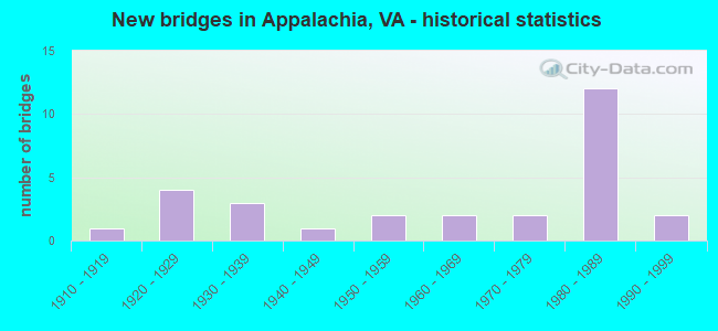
- New bridges - historical statistics
- 11910-1919
- 41920-1929
- 31930-1939
- 11940-1949
- 21950-1959
- 21960-1969
- 21970-1979
- 121980-1989
- 21990-1999

- Reconstructed bridges - Historical Statistics
- 31980-1989
- 31990-1999
- 62000-2009
- 22010-2019


- Bridge Condition - Deck
- 3.6%Very good
- 28.6%Good
- 28.6%Satisfactory
- 39.3%Fair

- Bridge Condition - Superstructure
- 3.6%Very good
- 14.3%Good
- 42.9%Satisfactory
- 39.3%Fair

- Bridge Condition - Substructure
- 14.3%Good
- 57.1%Satisfactory
- 28.6%Fair

- Bridge Condition - Channel
- 30.8%Very good
- 19.2%Good
- 26.9%Satisfactory
- 23.1%Fair
Find on map >> Show street view
Structure Number: 165, Location: 0.95-Rt. 611/1.26-Rt. 616 (Lat: 37.493306, Lng: -78.828656), Route carried "on" structure: County highway 663, Year Built: 1960, Status: Posted for load, Structure Length: 0.87m (2.85ft), Average Daily Traffic: 35 (year 2020), Truck Traffic: 3%, Average Future Daily Traffic: 38 (year 2040), Features Intersected: Bent Creek, Facility Carried by Structure: Colemans Mill Road
Minimum Vertical Clearance: 30+ m (98+ ft), Kilometerpoint: 7.241, Lanes on structure: 2, Owner: State Highway Agency, Approaching Roadway Width: 4.6m (15.1ft), Material/Design: Steel, Design/Construction: Stringer/Multi-beam, Number Of Spans In Main Unit: 1, Length of Maximum Span: 8.0m (26.2ft), Curb or Sidewalk Widths: Left: 0.2m (0.7ft), Right: 0.2m (0.7ft), Curb-To-Curb Width: 5.8m (19.0ft), Out-to-Out Width: 6.1m (20.0ft)
Condition: Deck: Very good, Superstructure: Fair, Substructure: Satisfactory, Channel: Satisfactory, Operating Rating: 21.8 metric tons, Method Used To Determine Operating Rating: Load Factor (LF), Inventory Rating: 12.7 metric tons, Method Used To Determine Inventory Rating: Load Factor (LF), Structural Evaluation: Meets minimum limits, Deck Geometry: Meets minimum limits, Waterway Adequacy: Somewhat better than minimum adequacy, Approach Roadway Alignment: Equal to present minimum criteria, Bridge Posting: Required (Relationship of Operating Rating to Maximum Legal Load: 30.0 - 39.9% below), Length Of Structure Improvement: 1.49m (4.89ft), Designated Inspection Frequency: Every 12 months, Inspection Date: August 2021, Bridge Improvement Cost: $260,000, Roadway Improvement Cost: $26,000, Total Project Cost: $391,000 ( Estimate for 2015), Deck Structure Type: Wood or Timber, Wearing Surface/Protective System: Wearing Surface: Bituminous, Membrane: Preformed Fabric
Find on map >> Show street view
Structure Number: 19249, Location: .43M TO 78 & .11M TO 68 (Lat: 36.901903, Lng: -82.785936), Route carried "on" structure: Business US 23, Year Built: 1937, Year Reconstructed: 2009, Status: Open, Structure Length: 3.90m (12.80ft), Average Daily Traffic: 4,276 (year 2020), Truck Traffic: 5%, Average Future Daily Traffic: 5,986 (year 2040), Design Load: HS 20+Mod, Features Intersected: NS RAILWAY
Minimum Vertical Clearance: 30+ m (98+ ft), Kilometerpoint: 10.114, Lanes on structure: 2, Owner: State Highway Agency, Approaching Roadway Width: 12.2m (40.0ft), Skew: 4 degrees, Material/Design: Steel, Design/Construction: Stringer/Multi-beam, Number Of Spans In Main Unit: 3, Length of Maximum Span: 21.0m (68.9ft), Curb or Sidewalk Widths: Left: 0.0m, Right: 1.5m (4.9ft), Curb-To-Curb Width: 12.2m (40.0ft), Out-to-Out Width: 14.2m (46.6ft)
Condition: Deck: Good, Superstructure: Satisfactory, Substructure: Fair, Operating Rating: 38.1 metric tons, Method Used To Determine Operating Rating: Load and Resistance Factor (LRFR), Inventory Rating: 29.0 metric tons, Method Used To Determine Inventory Rating: Load and Resistance Factor (LRFR), Structural Evaluation: Somewhat better than minimum adequacy, Deck Geometry: Equal to present minimum criteria, Underclear: High priority of replacement, Approach Roadway Alignment: Better than present minimum criteria, Length Of Structure Improvement: 3.87m (12.70ft), Designated Inspection Frequency: Every 24 months, Other Special Inspection Frequency: Every 24 months, Inspection Date: March 2021, Other Special Inspection Date: March 2021, Bridge Improvement Cost: $330,000, Roadway Improvement Cost: $30,000, Total Project Cost: $468,000, Deck Structure Type: Concrete Cast-file-Place, Wearing Surface/Protective System: Wearing Surface: Monolithic Concrete, Membrane: Built-up, Deck Protection: Other
Find on map >> Show street view
Structure Number: 19251, Location: .4 M FR RT 68&.16WCL APPL (Lat: 36.897103, Lng: -82.790539), Route carried "on" structure: Business US 23, Year Built: 1929, Year Reconstructed: 1991, Status: Open, Structure Length: 1.49m (4.89ft), Average Daily Traffic: 4,276 (year 2020), Truck Traffic: 5%, Average Future Daily Traffic: 5,986 (year 2040), Design Load: H 15, Features Intersected: PIGEON CREEK
Minimum Vertical Clearance: 30+ m (98+ ft), Kilometerpoint: 9.318, Lanes on structure: 2, Base Highway Network: Yes, Owner: State Highway Agency, Approaching Roadway Width: 9.1m (29.9ft), Material/Design: Concrete, Design/Construction: Tee Beam, Number Of Spans In Main Unit: 1, Length of Maximum Span: 14.2m (46.6ft), Curb-To-Curb Width: 11.9m (39.0ft), Out-to-Out Width: 12.8m (42.0ft)
Condition: Deck: Fair, Superstructure: Fair, Substructure: Fair, Channel: Fair, Operating Rating: 44.5 metric tons, Method Used To Determine Operating Rating: Load Factor (LF), Inventory Rating: 26.3 metric tons, Method Used To Determine Inventory Rating: Load Factor (LF), Structural Evaluation: Somewhat better than minimum adequacy, Deck Geometry: Somewhat better than minimum adequacy, Waterway Adequacy: Meets minimum limits, Approach Roadway Alignment: Better than present minimum criteria, Length Of Structure Improvement: 1.49m (4.89ft), Designated Inspection Frequency: Every 24 months, Inspection Date: August 2020, Bridge Improvement Cost: $206,000, Roadway Improvement Cost: $25,000, Total Project Cost: $300,000 ( Estimate for 2017), Deck Structure Type: Concrete Cast-file-Place, Wearing Surface/Protective System: Wearing Surface: Bituminous
Find on map >> Show street view
Structure Number: 19265, Location: 5.53MTOSCLNORT&4.01MTO78 (Lat: 36.922122, Lng: -82.729056), Route carried "on" structure: Business US 23, Year Built: 1965, Year Reconstructed: 2008, Status: Open, Structure Length: 12.04m (39.50ft), Average Daily Traffic: 4,276 (year 2020), Truck Traffic: 5%, Average Future Daily Traffic: 5,986 (year 2040), Design Load: HS 20+Mod, Features Intersected: ROARING FORK CK &INT RR, Facility Carried by Structure: KENT JUNCTION RD.
Minimum Vertical Clearance: 30+ m (98+ ft), Kilometerpoint: 16.999, Lanes on structure: 2, Owner: State Highway Agency, Approaching Roadway Width: 7.3m (24.0ft), Skew: 4 degrees, Material/Design: Steel, Design/Construction: Stringer/Multi-beam, Number Of Spans In Main Unit: 6, Length of Maximum Span: 26.5m (86.9ft), Curb-To-Curb Width: 10.8m (35.4ft), Out-to-Out Width: 11.4m (37.4ft)
Condition: Deck: Good, Superstructure: Good, Substructure: Satisfactory, Channel: Very good, Operating Rating: 78.9 metric tons, Method Used To Determine Operating Rating: Load and Resistance Factor (LRFR), Inventory Rating: 60.8 metric tons, Method Used To Determine Inventory Rating: Load and Resistance Factor (LRFR), Structural Evaluation: Equal to present minimum criteria, Deck Geometry: Somewhat better than minimum adequacy, Underclear: Superior to present desirable criteria, Approach Roadway Alignment: Better than present minimum criteria, Length Of Structure Improvement: 12.13m (39.80ft), Designated Inspection Frequency: Every 24 months, Inspection Date: July 2020, Deck Structure Type: Concrete Cast-file-Place, Wearing Surface/Protective System: Deck Protection: Epoxy Coated Reinforcing
Find on map >> Show street view
Structure Number: 19292, Location: 1MTOECLAPPALAC.&.05MTO78 (Lat: 36.906278, Lng: -82.781972), Route carried "on" structure: Business US 23, Year Built: 1987, Status: Open, Structure Length: 19.14m (62.80ft), Average Daily Traffic: 4,276 (year 2020), Truck Traffic: 5%, Average Future Daily Traffic: 5,986 (year 2040), Design Load: HS 20+Mod, Features Intersected: RTE 78 & CALLAHAN CR&NSR, Facility Carried by Structure: EAST MAIN ST.
Minimum Vertical Clearance: 30+ m (98+ ft), Kilometerpoint: 10.912, Lanes on structure: 2, Lanes under structure: 2, Base Highway Network: Yes, Owner: State Highway Agency, Approaching Roadway Width: 17.7m (58.1ft), Skew: 9 degrees, Material/Design: Steel continuous, Design/Construction: Stringer/Multi-beam, Number Of Spans In Main Unit: 6, Length of Maximum Span: 36.6m (120.1ft), Curb or Sidewalk Widths: Left: 2.4m (7.9ft), Right: 2.4m (7.9ft), Curb-To-Curb Width: 12.2m (40.0ft), Out-to-Out Width: 17.7m (58.1ft)
Condition: Deck: Satisfactory, Superstructure: Satisfactory, Substructure: Satisfactory, Channel: Very good, Operating Rating: 89.8 metric tons, Method Used To Determine Operating Rating: Load and Resistance Factor (LRFR), Inventory Rating: 70.8 metric tons, Method Used To Determine Inventory Rating: Load and Resistance Factor (LRFR), Structural Evaluation: Equal to present minimum criteria, Deck Geometry: Equal to present minimum criteria, Underclear: Somewhat better than minimum adequacy, Waterway Adequacy: Equal to present desirable criteria, Approach Roadway Alignment: Equal to present desirable criteria, Length Of Structure Improvement: 19.14m (62.80ft), Designated Inspection Frequency: Every 24 months, Inspection Date: March 2020, Bridge Improvement Cost: $550,000, Roadway Improvement Cost: $50,000, Total Project Cost: $780,000 ( Estimate for 2014), Deck Structure Type: Concrete Cast-file-Place, Wearing Surface/Protective System: Wearing Surface: Monolithic Concrete
Find on map >> Show street view
Structure Number: 19318, Location: .09M TO 23B& .13M TO 160 (Lat: 36.901156, Lng: -82.787681), Route carried "on" structure: State highway 68, Year Built: 1986, Status: Open, Structure Length: 5.55m (18.21ft), Average Daily Traffic: 763 (year 2020), Truck Traffic: 3%, Average Future Daily Traffic: 839 (year 2040), Design Load: HS 20+Mod, Features Intersected: NS RAILWAY, Facility Carried by Structure: NORTH INMAN ST.
Minimum Vertical Clearance: 8.53m (27.99ft), Kilometerpoint: 9.664, Lanes on structure: 2, Owner: State Highway Agency, Approaching Roadway Width: 17.4m (57.1ft), Skew: 1 degrees, Material/Design: Steel, Design/Construction: Stringer/Multi-beam, Number Of Spans In Main Unit: 3, Length of Maximum Span: 27.4m (89.9ft), Curb or Sidewalk Widths: Left: 2.3m (7.5ft), Right: 2.3m (7.5ft), Curb-To-Curb Width: 8.5m (27.9ft), Out-to-Out Width: 13.7m (44.9ft)
Condition: Deck: Fair, Superstructure: Satisfactory, Substructure: Fair, Operating Rating: 67.1 metric tons, Method Used To Determine Operating Rating: Load and Resistance Factor (LRFR), Inventory Rating: 51.7 metric tons, Method Used To Determine Inventory Rating: Load and Resistance Factor (LRFR), Structural Evaluation: Somewhat better than minimum adequacy, Deck Geometry: Somewhat better than minimum adequacy, Underclear: Somewhat better than minimum adequacy, Approach Roadway Alignment: Equal to present desirable criteria, Length Of Structure Improvement: 5.55m (18.21ft), Designated Inspection Frequency: Every 24 months, Inspection Date: July 2020, Bridge Improvement Cost: $437,000, Roadway Improvement Cost: $25,000, Total Project Cost: $601,000 ( Estimate for 2014), Deck Structure Type: Concrete Cast-file-Place, Wearing Surface/Protective System: Wearing Surface: Bituminous
Find on map >> Show street view
Structure Number: 19319, Location: .08FRRT.160;5.70TOWISE CL (Lat: 36.902686, Lng: -82.791142), Route carried "on" structure: State highway 68, Year Built: 1986, Status: Open, Structure Length: 14.81m (48.59ft), Average Daily Traffic: 763 (year 2020), Truck Traffic: 3%, Average Future Daily Traffic: 839 (year 2040), Design Load: HS 20+Mod, Features Intersected: LOONEY CK, Facility Carried by Structure: EXETER RD.
Minimum Vertical Clearance: 30+ m (98+ ft), Kilometerpoint: 9.313, Lanes on structure: 2, Owner: State Highway Agency, Approaching Roadway Width: 8.5m (27.9ft), Material/Design: Steel continuous, Design/Construction: Stringer/Multi-beam, Number Of Spans In Main Unit: 4, Length of Maximum Span: 38.1m (125.0ft), Curb-To-Curb Width: 13.9m (45.6ft), Out-to-Out Width: 14.9m (48.9ft)
Condition: Deck: Good, Superstructure: Satisfactory, Substructure: Satisfactory, Channel: Good, Operating Rating: 89.8 metric tons, Method Used To Determine Operating Rating: Load and Resistance Factor (LRFR), Inventory Rating: 68.9 metric tons, Method Used To Determine Inventory Rating: Load and Resistance Factor (LRFR), Structural Evaluation: Equal to present minimum criteria, Deck Geometry: Superior to present desirable criteria, Waterway Adequacy: Equal to present desirable criteria, Approach Roadway Alignment: Equal to present desirable criteria, Length Of Structure Improvement: 14.81m (48.59ft), Designated Inspection Frequency: Every 24 months, Inspection Date: September 2021, Bridge Improvement Cost: $32,000, Roadway Improvement Cost: $25,000, Total Project Cost: $74,000 ( Estimate for 2018), Deck Structure Type: Concrete Cast-file-Place, Wearing Surface/Protective System: Deck Protection: Epoxy Coated Reinforcing
Find on map >> Show street view
Structure Number: 19322, Location: .63MTO160&5.15MTOLEECO.L (Lat: 36.895622, Lng: -82.792583), Route carried "on" structure: State highway 68, Year Built: 1986, Status: Open, Structure Length: 9.94m (32.61ft), Average Daily Traffic: 763 (year 2020), Truck Traffic: 3%, Average Future Daily Traffic: 839 (year 2040), Design Load: HS 20+Mod, Features Intersected: NS RWY & PIGEON CREEK, Facility Carried by Structure: EXETER RD.
Minimum Vertical Clearance: 30+ m (98+ ft), Kilometerpoint: 8.397, Lanes on structure: 2, Owner: State Highway Agency, Approaching Roadway Width: 14.6m (47.9ft), Material/Design: Steel continuous, Design/Construction: Stringer/Multi-beam, Number Of Spans In Main Unit: 4, Length of Maximum Span: 27.4m (89.9ft), Curb-To-Curb Width: 13.8m (45.3ft), Out-to-Out Width: 14.8m (48.6ft)
Condition: Deck: Fair, Superstructure: Satisfactory, Substructure: Satisfactory, Channel: Good, Operating Rating: 75.3 metric tons, Method Used To Determine Operating Rating: Load and Resistance Factor (LRFR), Inventory Rating: 58.1 metric tons, Method Used To Determine Inventory Rating: Load and Resistance Factor (LRFR), Structural Evaluation: Equal to present minimum criteria, Deck Geometry: Superior to present desirable criteria, Underclear: Superior to present desirable criteria, Waterway Adequacy: Equal to present desirable criteria, Approach Roadway Alignment: Equal to present desirable criteria, Designated Inspection Frequency: Every 24 months, Inspection Date: June 2021, Deck Structure Type: Concrete Cast-file-Place, Wearing Surface/Protective System: Wearing Surface: Monolithic Concrete
Find on map >> Show street view
Structure Number: 19338, Location: .05MTO23B&1.30NCLAPPALACH (Lat: 36.906106, Lng: -82.781675), Route carried "on" structure: State highway 78, Year Built: 1926, Year Reconstructed: 2008, Status: Open, Structure Length: 3.81m (12.50ft), Average Daily Traffic: 1,692 (year 2020), Truck Traffic: 12%, Average Future Daily Traffic: 1,861 (year 2040), Design Load: HS 20+Mod, Features Intersected: CALLIHAN BRANCH, Facility Carried by Structure: MAIN ST.
Minimum Vertical Clearance: 30+ m (98+ ft), Kilometerpoint: 0.161, Lanes on structure: 2, Owner: State Highway Agency, Approaching Roadway Width: 7.3m (24.0ft), Material/Design: Concrete, Design/Construction: Arch - Deck, Number Of Spans In Main Unit: 1, Length of Maximum Span: 38.1m (125.0ft), Curb or Sidewalk Widths: Left: 1.5m (4.9ft), Right: 0.0m, Curb-To-Curb Width: 7.4m (24.3ft), Out-to-Out Width: 9.8m (32.2ft)
Condition: Deck: Satisfactory, Superstructure: Satisfactory, Substructure: Good, Channel: Very good, Operating Rating: 44.5 metric tons, Method Used To Determine Operating Rating: Field evaluation and documented engineering judgment, Inventory Rating: 32.7 metric tons, Method Used To Determine Inventory Rating: Field evaluation and documented engineering judgment, Structural Evaluation: Equal to present minimum criteria, Deck Geometry: Meets minimum limits, Waterway Adequacy: Better than present minimum criteria, Approach Roadway Alignment: Better than present minimum criteria, Length Of Structure Improvement: 3.78m (12.40ft), Designated Inspection Frequency: Every 24 months, Inspection Date: October 2021, Bridge Improvement Cost: $300,000, Roadway Improvement Cost: $57,000, Total Project Cost: $464,000 ( Estimate for 2019), Deck Structure Type: Concrete Cast-file-Place, Wearing Surface/Protective System: Wearing Surface: Epoxy Overlay, Deck Protection: Epoxy Coated Reinforcing
Find on map >> Show street view
Structure Number: 19339, Location: .24MTO23&1.1MTONCITYLIMAP (Lat: 36.909186, Lng: -82.784167), Route carried "on" structure: State highway 78, Year Built: 1942, Year Reconstructed: 2009, Status: Open, Structure Length: 4.30m (14.11ft), Average Daily Traffic: 1,692 (year 2020), Truck Traffic: 12%, Average Future Daily Traffic: 1,861 (year 2040), Design Load: HS 20, Features Intersected: CALLAHAN CREEK
Minimum Vertical Clearance: 30+ m (98+ ft), Kilometerpoint: 0.631, Lanes on structure: 2, Owner: State Highway Agency, Approaching Roadway Width: 11.6m (38.1ft), Skew: 6 degrees, Material/Design: Steel continuous, Design/Construction: Stringer/Multi-beam, Number Of Spans In Main Unit: 3, Length of Maximum Span: 14.9m (48.9ft), Curb or Sidewalk Widths: Left: 0.0m, Right: 1.5m (4.9ft), Curb-To-Curb Width: 12.2m (40.0ft), Out-to-Out Width: 14.8m (48.6ft)
Condition: Deck: Good, Superstructure: Very good, Substructure: Satisfactory, Channel: Fair, Operating Rating: 76.2 metric tons, Method Used To Determine Operating Rating: Load and Resistance Factor (LRFR), Inventory Rating: 59.0 metric tons, Method Used To Determine Inventory Rating: Load and Resistance Factor (LRFR), Structural Evaluation: Equal to present minimum criteria, Deck Geometry: Better than present minimum criteria, Waterway Adequacy: Better than present minimum criteria, Approach Roadway Alignment: Better than present minimum criteria, Length Of Structure Improvement: 4.24m (13.91ft), Designated Inspection Frequency: Every 24 months, Inspection Date: December 2021, Deck Structure Type: Concrete Cast-file-Place, Wearing Surface/Protective System: Deck Protection: Epoxy Coated Reinforcing
Find on map >> Show street view
Structure Number: 19341, Location: 2.72M TO 23&1.03M TO 600 (Lat: 36.938767, Lng: -82.794758), Route carried "on" structure: State highway 78, Year Built: 1952, Year Reconstructed: 1998, Status: Open, Structure Length: 2.65m (8.69ft), Average Daily Traffic: 917 (year 2020), Truck Traffic: 41%, Average Future Daily Traffic: 1,010 (year 2040), Design Load: HS 20+Mod, Features Intersected: CALLAHAN CREEK, Facility Carried by Structure: CALLAHAN AVE.
Minimum Vertical Clearance: 30+ m (98+ ft), Kilometerpoint: 4.613, Lanes on structure: 2, Owner: State Highway Agency, Approaching Roadway Width: 6.4m (21.0ft), Skew: 3 degrees, Material/Design: Concrete, Design/Construction: Slab, Number Of Spans In Main Unit: 3, Length of Maximum Span: 10.1m (33.1ft), Curb-To-Curb Width: 7.3m (24.0ft), Out-to-Out Width: 7.9m (25.9ft)
Condition: Deck: Good, Superstructure: Good, Substructure: Fair, Channel: Satisfactory, Operating Rating: 89.8 metric tons, Method Used To Determine Operating Rating: Load and Resistance Factor (LRFR), Inventory Rating: 88.9 metric tons, Method Used To Determine Inventory Rating: Load and Resistance Factor (LRFR), Structural Evaluation: Somewhat better than minimum adequacy, Deck Geometry: Meets minimum limits, Waterway Adequacy: Better than present minimum criteria, Approach Roadway Alignment: Better than present minimum criteria, Length Of Structure Improvement: 2.74m (8.99ft), Designated Inspection Frequency: Every 24 months, Inspection Date: April 2020, Bridge Improvement Cost: $174,000, Roadway Improvement Cost: $20,000, Total Project Cost: $252,000 ( Estimate for 2018), Deck Structure Type: Concrete Cast-file-Place, Wearing Surface/Protective System: Deck Protection: Epoxy Coated Reinforcing
Find on map >> Show street view
Structure Number: 19342, Location: .38M TO685 & .63M TO 600 (Lat: 36.942936, Lng: -82.796794), Route carried "on" structure: State highway 78, Year Built: 1952, Year Reconstructed: 1988, Status: Open, Structure Length: 2.65m (8.69ft), Average Daily Traffic: 385 (year 2020), Truck Traffic: 41%, Average Future Daily Traffic: 424 (year 2040), Design Load: HS 20+Mod, Features Intersected: CALLAHAN CREEK, Facility Carried by Structure: CALLAHAN AVE.
Minimum Vertical Clearance: 30+ m (98+ ft), Kilometerpoint: 5.207, Lanes on structure: 2, Owner: State Highway Agency, Approaching Roadway Width: 8.2m (26.9ft), Skew: 3 degrees, Material/Design: Prestressed concrete, Design/Construction: Box Beam or Girders - Multiple, Number Of Spans In Main Unit: 2, Length of Maximum Span: 13.1m (43.0ft), Curb-To-Curb Width: 9.4m (30.8ft), Out-to-Out Width: 10.1m (33.1ft)
Condition: Deck: Fair, Superstructure: Fair, Substructure: Satisfactory, Channel: Good, Operating Rating: 81.6 metric tons, Method Used To Determine Operating Rating: Load and Resistance Factor (LRFR), Inventory Rating: 63.5 metric tons, Method Used To Determine Inventory Rating: Load and Resistance Factor (LRFR), Structural Evaluation: Somewhat better than minimum adequacy, Deck Geometry: Equal to present minimum criteria, Waterway Adequacy: Better than present minimum criteria, Approach Roadway Alignment: Better than present minimum criteria, Designated Inspection Frequency: Every 24 months, Inspection Date: April 2020, Deck Structure Type: Concrete Cast-file-Place, Wearing Surface/Protective System: Wearing Surface: Bituminous
Find on map >> Show street view
Structure Number: 19345, Location: 5.0MTOKY.STLINE&3.0MTO68 (Lat: 36.916964, Lng: -82.835350), Route carried "on" structure: State highway 160, Year Built: 1981, Status: Open, Structure Length: 1.49m (4.89ft), Average Daily Traffic: 211 (year 2020), Truck Traffic: 4%, Average Future Daily Traffic: 232 (year 2040), Design Load: HS 20+Mod, Features Intersected: LOONEY CREEK, Facility Carried by Structure: N. INMAN ROAD
Minimum Vertical Clearance: 30+ m (98+ ft), Kilometerpoint: 8.045, Lanes on structure: 2, Base Highway Network: Yes, Owner: State Highway Agency, Approaching Roadway Width: 6.7m (22.0ft), Skew: 3 degrees, Material/Design: Concrete, Design/Construction: Frame, Number Of Spans In Main Unit: 2, Length of Maximum Span: 7.6m (24.9ft), Curb or Sidewalk Widths: Left: 0.3m (1.0ft), Right: 0.3m (1.0ft), Curb-To-Curb Width: 10.1m (33.1ft), Out-to-Out Width: 11.0m (36.1ft)
Condition: Deck: Fair, Superstructure: Fair, Substructure: Satisfactory, Channel: Fair, Operating Rating: 53.5 metric tons, Method Used To Determine Operating Rating: Load and Resistance Factor (LRFR), Inventory Rating: 41.7 metric tons, Method Used To Determine Inventory Rating: Load and Resistance Factor (LRFR), Structural Evaluation: Somewhat better than minimum adequacy, Deck Geometry: Better than present minimum criteria, Waterway Adequacy: Better than present minimum criteria, Approach Roadway Alignment: Better than present minimum criteria, Designated Inspection Frequency: Every 24 months, Inspection Date: March 2021, Deck Structure Type: Concrete Cast-file-Place, Wearing Surface/Protective System: Wearing Surface: Bituminous, Deck Protection: Epoxy Coated Reinforcing
Find on map >> Show street view
Structure Number: 1935, Location: 1.28MTOENDMAINT&.40MTO78 (Lat: 36.953139, Lng: -82.791753), Route carried "on" structure: County highway 600, Year Built: 1972, Year Reconstructed: 1997, Status: Posted for load, Structure Length: 1.37m (4.49ft), Average Daily Traffic: 385 (year 2020), Truck Traffic: 41%, Average Future Daily Traffic: 539 (year 2040), Design Load: HS 20+Mod, Features Intersected: CALLIHAN CREEK, Facility Carried by Structure: STONEGA ROAD
Minimum Vertical Clearance: 30+ m (98+ ft), Kilometerpoint: 0.644, Lanes on structure: 2, Owner: State Highway Agency, Approaching Roadway Width: 7.3m (24.0ft), Skew: 1 degrees, Material/Design: Steel, Design/Construction: Stringer/Multi-beam, Number Of Spans In Main Unit: 2, Length of Maximum Span: 12.5m (41.0ft), Curb-To-Curb Width: 7.3m (24.0ft), Out-to-Out Width: 7.9m (25.9ft)
Condition: Deck: Good, Superstructure: Fair, Substructure: Satisfactory, Channel: Very good, Operating Rating: 38.1 metric tons, Method Used To Determine Operating Rating: Load Factor (LF), Inventory Rating: 22.7 metric tons, Method Used To Determine Inventory Rating: Load Factor (LF), Structural Evaluation: Somewhat better than minimum adequacy, Deck Geometry: Somewhat better than minimum adequacy, Waterway Adequacy: Better than present minimum criteria, Approach Roadway Alignment: Equal to present minimum criteria, Length Of Structure Improvement: 1.34m (4.40ft), Designated Inspection Frequency: Every 24 months, Inspection Date: October 2020, Bridge Improvement Cost: $92,000, Roadway Improvement Cost: $20,000, Total Project Cost: $146,000 ( Estimate for 2017), Deck Structure Type: Wood or Timber, Wearing Surface/Protective System: Wearing Surface: Bituminous
Find on map >> Show street view
Structure Number: 19351, Location: .65MTO78&1.03MTOENDMAINT. (Lat: 36.953958, Lng: -82.787461), Route carried "on" structure: County highway 600, Year Built: 1982, Status: Open, Structure Length: 1.95m (6.40ft), Average Daily Traffic: 385 (year 2020), Truck Traffic: 41%, Average Future Daily Traffic: 539 (year 2040), Design Load: HS 20+Mod, Features Intersected: CALAHAN CREEK, Facility Carried by Structure: STONEGA RD.
Minimum Vertical Clearance: 30+ m (98+ ft), Kilometerpoint: 1.046, Lanes on structure: 2, Owner: State Highway Agency, Approaching Roadway Width: 6.4m (21.0ft), Skew: 4 degrees, Material/Design: Concrete, Design/Construction: Slab, Number Of Spans In Main Unit: 2, Length of Maximum Span: 9.8m (32.2ft), Curb-To-Curb Width: 7.3m (24.0ft), Out-to-Out Width: 7.9m (25.9ft)
Condition: Deck: Fair, Superstructure: Fair, Substructure: Satisfactory, Channel: Satisfactory, Operating Rating: 89.8 metric tons, Method Used To Determine Operating Rating: Load and Resistance Factor (LRFR), Inventory Rating: 88.9 metric tons, Method Used To Determine Inventory Rating: Load and Resistance Factor (LRFR), Structural Evaluation: Somewhat better than minimum adequacy, Deck Geometry: Somewhat better than minimum adequacy, Waterway Adequacy: Better than present minimum criteria, Approach Roadway Alignment: Better than present minimum criteria, Designated Inspection Frequency: Every 24 months, Inspection Date: October 2021, Deck Structure Type: Concrete Cast-file-Place
Find on map >> Show street view
Structure Number: 19353, Location: .0MTOENDMAINT& 1.68MTO 78 (Lat: 36.962900, Lng: -82.776775), Route carried "on" structure: County highway 600, Year Built: 1982, Status: Open, Structure Length: 1.10m (3.61ft), Average Daily Traffic: 385 (year 2020), Truck Traffic: 41%, Average Future Daily Traffic: 578 (year 2041), Design Load: HS 20+Mod, Features Intersected: CALLAHAN CREEK, Facility Carried by Structure: STONEGA RD.
Minimum Vertical Clearance: 30+ m (98+ ft), Kilometerpoint: 2.703, Lanes on structure: 2, Owner: State Highway Agency, Approaching Roadway Width: 6.4m (21.0ft), Skew: 3 degrees, Material/Design: Concrete, Design/Construction: Slab, Number Of Spans In Main Unit: 1, Length of Maximum Span: 10.4m (34.1ft), Curb-To-Curb Width: 7.3m (24.0ft), Out-to-Out Width: 7.9m (25.9ft)
Condition: Deck: Fair, Superstructure: Fair, Substructure: Satisfactory, Channel: Satisfactory, Operating Rating: 89.8 metric tons, Method Used To Determine Operating Rating: Load and Resistance Factor (LRFR), Inventory Rating: 69.9 metric tons, Method Used To Determine Inventory Rating: Load and Resistance Factor (LRFR), Structural Evaluation: Somewhat better than minimum adequacy, Deck Geometry: Somewhat better than minimum adequacy, Waterway Adequacy: Better than present minimum criteria, Approach Roadway Alignment: Better than present minimum criteria, Designated Inspection Frequency: Every 24 months, Inspection Date: October 2021, Deck Structure Type: Concrete Cast-file-Place
Find on map >> Show street view
Structure Number: 19454, Location: .2M TO 78 & 1.9M TO 812 (Lat: 36.940686, Lng: -82.798197), Route carried "on" structure: County highway 685, Year Built: 1981, Status: Open, Structure Length: 2.93m (9.61ft), Average Daily Traffic: 721 (year 2020), Truck Traffic: 22%, Average Future Daily Traffic: 1,009 (year 2040), Design Load: HS 20+Mod, Features Intersected: CALLAHAN CREEK, Facility Carried by Structure: RODA RD.
Minimum Vertical Clearance: 30+ m (98+ ft), Kilometerpoint: 3.977, Lanes on structure: 2, Owner: State Highway Agency, Approaching Roadway Width: 7.3m (24.0ft), Material/Design: Concrete, Design/Construction: Slab, Number Of Spans In Main Unit: 3, Length of Maximum Span: 9.8m (32.2ft), Curb-To-Curb Width: 6.7m (22.0ft), Out-to-Out Width: 7.3m (24.0ft)
Condition: Deck: Fair, Superstructure: Fair, Substructure: Fair, Channel: Fair, Operating Rating: 89.8 metric tons, Method Used To Determine Operating Rating: Load and Resistance Factor (LRFR), Inventory Rating: 86.2 metric tons, Method Used To Determine Inventory Rating: Load and Resistance Factor (LRFR), Structural Evaluation: Somewhat better than minimum adequacy, Deck Geometry: Meets minimum limits, Waterway Adequacy: Better than present minimum criteria, Approach Roadway Alignment: Better than present minimum criteria, Length Of Structure Improvement: 2.93m (9.61ft), Designated Inspection Frequency: Every 24 months, Inspection Date: September 2021, Bridge Improvement Cost: $173,000, Roadway Improvement Cost: $25,000, Total Project Cost: $257,000 ( Estimate for 2018), Deck Structure Type: Concrete Cast-file-Place
Find on map >> Show street view
Structure Number: 19455, Location: 1.15M TO 78 & .95M TO 812 (Lat: 36.947178, Lng: -82.812819), Route carried "on" structure: County highway 685, Year Built: 1981, Year Reconstructed: 2008, Status: Open, Structure Length: 1.71m (5.61ft), Average Daily Traffic: 721 (year 2020), Truck Traffic: 22%, Average Future Daily Traffic: 1,009 (year 2040), Design Load: HS 20+Mod, Features Intersected: MUD LICK CREEK #1, Facility Carried by Structure: RODA RD.
Minimum Vertical Clearance: 30+ m (98+ ft), Kilometerpoint: 2.462, Lanes on structure: 2, Owner: State Highway Agency, Approaching Roadway Width: 7.6m (24.9ft), Skew: 3 degrees, Material/Design: Prestressed concrete, Design/Construction: Box Beam or Girders - Multiple, Number Of Spans In Main Unit: 1, Length of Maximum Span: 16.4m (53.8ft), Curb-To-Curb Width: 7.6m (24.9ft), Out-to-Out Width: 8.2m (26.9ft)
Condition: Deck: Satisfactory, Superstructure: Satisfactory, Substructure: Good, Channel: Very good, Operating Rating: 86.2 metric tons, Method Used To Determine Operating Rating: Load and Resistance Factor (LRFR), Inventory Rating: 59.0 metric tons, Method Used To Determine Inventory Rating: Load and Resistance Factor (LRFR), Structural Evaluation: Equal to present minimum criteria, Deck Geometry: Meets minimum limits, Waterway Adequacy: Better than present minimum criteria, Approach Roadway Alignment: Better than present minimum criteria, Length Of Structure Improvement: 1.71m (5.61ft), Designated Inspection Frequency: Every 24 months, Inspection Date: December 2020, Deck Structure Type: Concrete Cast-file-Place, Wearing Surface/Protective System: Deck Protection: Epoxy Coated Reinforcing
Find on map >> Show street view
Structure Number: 19456, Location: .01MTO812&.99MTOENDMAINT. (Lat: 36.952200, Lng: -82.819706), Route carried "on" structure: County highway 685, Year Built: 1981, Status: Open, Structure Length: 2.19m (7.19ft), Average Daily Traffic: 367 (year 2016), Truck Traffic: 22%, Average Future Daily Traffic: 496 (year 2040), Design Load: HS 20+Mod, Features Intersected: MUD LICK CREEK #3, Facility Carried by Structure: RODA ROAD
Minimum Vertical Clearance: 30+ m (98+ ft), Kilometerpoint: 1.572, Lanes on structure: 2, Owner: State Highway Agency, Approaching Roadway Width: 6.7m (22.0ft), Material/Design: Concrete, Design/Construction: Slab, Number Of Spans In Main Unit: 2, Length of Maximum Span: 10.4m (34.1ft), Curb-To-Curb Width: 6.7m (22.0ft), Out-to-Out Width: 7.3m (24.0ft)
Condition: Deck: Fair, Superstructure: Fair, Substructure: Satisfactory, Channel: Satisfactory, Operating Rating: 89.8 metric tons, Method Used To Determine Operating Rating: Load and Resistance Factor (LRFR), Inventory Rating: 68.9 metric tons, Method Used To Determine Inventory Rating: Load and Resistance Factor (LRFR), Structural Evaluation: Somewhat better than minimum adequacy, Deck Geometry: Meets minimum limits, Waterway Adequacy: Better than present minimum criteria, Approach Roadway Alignment: Better than present minimum criteria, Length Of Structure Improvement: 2.19m (7.19ft), Designated Inspection Frequency: Every 24 months, Inspection Date: Febuary 2022, Bridge Improvement Cost: $60,000, Roadway Improvement Cost: $22,000, Total Project Cost: $92,000 ( Estimate for 2019), Deck Structure Type: Concrete Cast-file-Place
Find on map >> Show street view
Structure Number: 19457, Location: .60 TO 812 & 1.50 FR 78 (Lat: 36.949547, Lng: -82.816447), Route carried "on" structure: County highway 685, Year Built: 1997, Status: Open, Structure Length: 1.71m (5.61ft), Average Daily Traffic: 721 (year 2020), Truck Traffic: 22%, Average Future Daily Traffic: 1,009 (year 2040), Design Load: HS 20+Mod, Features Intersected: MUD LICK CREEK #2, Facility Carried by Structure: RODA ROAD
Minimum Vertical Clearance: 30+ m (98+ ft), Kilometerpoint: 1.899, Lanes on structure: 2, Owner: State Highway Agency, Approaching Roadway Width: 7.3m (24.0ft), Material/Design: Concrete, Design/Construction: Slab, Number Of Spans In Main Unit: 3, Length of Maximum Span: 8.5m (27.9ft), Curb-To-Curb Width: 7.3m (24.0ft), Out-to-Out Width: 8.5m (27.9ft)
Condition: Deck: Satisfactory, Superstructure: Satisfactory, Substructure: Fair, Channel: Fair, Operating Rating: 89.8 metric tons, Method Used To Determine Operating Rating: Load and Resistance Factor (LRFR), Inventory Rating: 88.9 metric tons, Method Used To Determine Inventory Rating: Load and Resistance Factor (LRFR), Structural Evaluation: Somewhat better than minimum adequacy, Deck Geometry: Meets minimum limits, Waterway Adequacy: Better than present minimum criteria, Approach Roadway Alignment: Equal to present minimum criteria, Length Of Structure Improvement: 1.77m (5.81ft), Designated Inspection Frequency: Every 24 months, Inspection Date: September 2021, Deck Structure Type: Concrete Cast-file-Place, Wearing Surface/Protective System: Deck Protection: Epoxy Coated Reinforcing
Find on map >> Show street view
Structure Number: 19458, Location: .1MTO78 & 2.3MTOENDMAINT. (Lat: 36.926436, Lng: -82.799028), Route carried "on" structure: County highway 686, Year Built: 1932, Year Reconstructed: 1985, Status: Open, Structure Length: 0.88m (2.89ft), Average Daily Traffic: 493 (year 2016), Average Future Daily Traffic: 552 (year 2040), Features Intersected: PREACHER CREEK, Facility Carried by Structure: DERBY ROAD
Minimum Vertical Clearance: 30+ m (98+ ft), Kilometerpoint: 3.693, Lanes on structure: 2, Owner: State Highway Agency, Approaching Roadway Width: 6.7m (22.0ft), Material/Design: Concrete, Design/Construction: Tee Beam, Number Of Spans In Main Unit: 1, Length of Maximum Span: 8.2m (26.9ft), Curb-To-Curb Width: 7.3m (24.0ft), Out-to-Out Width: 7.9m (25.9ft)
Condition: Deck: Fair, Superstructure: Fair, Substructure: Fair, Channel: Fair, Operating Rating: 44.5 metric tons, Method Used To Determine Operating Rating: Field evaluation and documented engineering judgment, Inventory Rating: 32.7 metric tons, Method Used To Determine Inventory Rating: Field evaluation and documented engineering judgment, Structural Evaluation: Somewhat better than minimum adequacy, Deck Geometry: Meets minimum limits, Waterway Adequacy: Better than present minimum criteria, Approach Roadway Alignment: Better than present minimum criteria, Designated Inspection Frequency: Every 24 months, Inspection Date: October 2021, Deck Structure Type: Concrete Cast-file-Place, Wearing Surface/Protective System: Wearing Surface: Bituminous
Find on map >> Show street view
Structure Number: 19471, Location: .01M TO728&.01M TO78 (Lat: 36.920892, Lng: -82.796267), Route carried "on" structure: County highway 729, Year Built: 1981, Status: Open, Structure Length: 2.19m (7.19ft), Average Daily Traffic: 443 (year 2016), Average Future Daily Traffic: 483 (year 2040), Design Load: HS 20+Mod, Features Intersected: CALLAHAN CREEK, Facility Carried by Structure: Andover Road
Minimum Vertical Clearance: 30+ m (98+ ft), Kilometerpoint: 0.016, Lanes on structure: 2, Owner: State Highway Agency, Approaching Roadway Width: 6.1m (20.0ft), Material/Design: Concrete, Design/Construction: Slab, Number Of Spans In Main Unit: 2, Length of Maximum Span: 11.0m (36.1ft), Curb-To-Curb Width: 7.3m (24.0ft), Out-to-Out Width: 7.9m (25.9ft)
Condition: Deck: Satisfactory, Superstructure: Satisfactory, Substructure: Fair, Channel: Satisfactory, Operating Rating: 89.8 metric tons, Method Used To Determine Operating Rating: Load and Resistance Factor (LRFR), Inventory Rating: 69.9 metric tons, Method Used To Determine Inventory Rating: Load and Resistance Factor (LRFR), Structural Evaluation: Somewhat better than minimum adequacy, Deck Geometry: Meets minimum limits, Waterway Adequacy: Better than present minimum criteria, Approach Roadway Alignment: Better than present minimum criteria, Length Of Structure Improvement: 2.19m (7.19ft), Designated Inspection Frequency: Every 24 months, Inspection Date: June 2021, Deck Structure Type: Concrete Cast-file-Place
Find on map >> Show street view
Structure Number: 19488, Location: .28MTOENDMAINT &.03MTO68 (Lat: 36.883942, Lng: -82.806661), Route carried "on" structure: County highway 810, Year Built: 1932, Year Reconstructed: 2010, Status: Open, Structure Length: 1.52m (4.99ft), Average Daily Traffic: 35 (year 2016), Average Future Daily Traffic: 39 (year 2040), Design Load: HS 20+Mod, Features Intersected: PIGEON CREEK, Facility Carried by Structure: LOWER IMBODEN RD.
Minimum Vertical Clearance: 30+ m (98+ ft), Kilometerpoint: 0.048, Lanes on structure: 1, Owner: State Highway Agency, Approaching Roadway Width: 3.7m (12.1ft), Material/Design: Steel, Design/Construction: Stringer/Multi-beam, Number Of Spans In Main Unit: 2, Length of Maximum Span: 7.6m (24.9ft), Curb or Sidewalk Widths: Left: 0.1m (0.3ft), Right: 0.1m (0.3ft), Curb-To-Curb Width: 3.1m (10.2ft), Out-to-Out Width: 4.3m (14.1ft)
Condition: Deck: Good, Superstructure: Good, Substructure: Satisfactory, Channel: Good, Operating Rating: 52.6 metric tons, Method Used To Determine Operating Rating: Load and Resistance Factor (LRFR), Inventory Rating: 39.9 metric tons, Method Used To Determine Inventory Rating: Load and Resistance Factor (LRFR), Structural Evaluation: Equal to present minimum criteria, Deck Geometry: High priority of replacement, Waterway Adequacy: Better than present minimum criteria, Approach Roadway Alignment: Better than present minimum criteria, Length Of Structure Improvement: 1.55m (5.09ft), Designated Inspection Frequency: Every 24 months, Inspection Date: June 2021, Deck Structure Type: Wood or Timber, Wearing Surface/Protective System: Wearing Surface: Bituminous
Find on map >> Show street view
Structure Number: 19499, Location: .04M TO 1309 & .00M TO 23 (Lat: 36.906042, Lng: -82.781597), Route carried "on" structure: County highway 1308, Year Built: 1926, Year Reconstructed: 2008, Status: Open, Structure Length: 2.50m (8.20ft), Average Daily Traffic: 589 (year 2016), Average Future Daily Traffic: 660 (year 2040), Design Load: HS 20+Mod, Features Intersected: CALLAHAN CREEK
Minimum Vertical Clearance: 30+ m (98+ ft), Kilometerpoint: 0.064, Lanes on structure: 2, Owner: State Highway Agency, Approaching Roadway Width: 7.3m (24.0ft), Material/Design: Concrete, Design/Construction: Arch - Deck, Number Of Spans In Main Unit: 1, Length of Maximum Span: 24.4m (80.1ft), Curb or Sidewalk Widths: Left: 1.5m (4.9ft), Right: 1.5m (4.9ft), Curb-To-Curb Width: 7.0m (23.0ft), Out-to-Out Width: 10.7m (35.1ft)
Condition: Deck: Satisfactory, Superstructure: Satisfactory, Substructure: Satisfactory, Channel: Good, Operating Rating: 44.5 metric tons, Method Used To Determine Operating Rating: Field evaluation and documented engineering judgment, Inventory Rating: 32.7 metric tons, Method Used To Determine Inventory Rating: Field evaluation and documented engineering judgment, Structural Evaluation: Equal to present minimum criteria, Deck Geometry: Meets minimum limits, Waterway Adequacy: Better than present minimum criteria, Approach Roadway Alignment: Better than present minimum criteria, Length Of Structure Improvement: 2.50m (8.20ft), Designated Inspection Frequency: Every 24 months, Inspection Date: January 2021, Bridge Improvement Cost: $150,000, Roadway Improvement Cost: $22,000, Total Project Cost: $224,000 ( Estimate for 2019), Deck Structure Type: Concrete Cast-file-Place, Wearing Surface/Protective System: Wearing Surface: Latex Concrete
Find on map >> Show street view
Structure Number: 195, Location: .0M TO 1312& .06M TO 1308 (Lat: 36.905739, Lng: -82.780436), Route carried "on" structure: County highway 1309, Year Built: 1990, Status: Open, Structure Length: 2.44m (8.01ft), Average Daily Traffic: 1,029 (year 2016), Average Future Daily Traffic: 1,062 (year 2040), Design Load: HS 20+Mod, Features Intersected: POWELL RIVER, Facility Carried by Structure: KILBOURNE AVE.
Minimum Vertical Clearance: 30+ m (98+ ft), Kilometerpoint: 0.185, Lanes on structure: 2, Owner: State Highway Agency, Approaching Roadway Width: 8.8m (28.9ft), Material/Design: Steel, Design/Construction: Stringer/Multi-beam, Number Of Spans In Main Unit: 1, Length of Maximum Span: 23.8m (78.1ft), Curb or Sidewalk Widths: Left: 0.0m, Right: 1.5m (4.9ft), Curb-To-Curb Width: 9.1m (29.9ft), Out-to-Out Width: 12.8m (42.0ft)
Condition: Deck: Satisfactory, Superstructure: Satisfactory, Substructure: Satisfactory, Channel: Very good, Operating Rating: 73.5 metric tons, Method Used To Determine Operating Rating: Load and Resistance Factor (LRFR), Inventory Rating: 57.2 metric tons, Method Used To Determine Inventory Rating: Load and Resistance Factor (LRFR), Structural Evaluation: Equal to present minimum criteria, Deck Geometry: Somewhat better than minimum adequacy, Waterway Adequacy: Better than present minimum criteria, Approach Roadway Alignment: Better than present minimum criteria, Designated Inspection Frequency: Every 24 months, Inspection Date: July 2021, Deck Structure Type: Concrete Cast-file-Place, Wearing Surface/Protective System: Deck Protection: Epoxy Coated Reinforcing
Find on map >> Show street view
Structure Number: 19501, Location: .0M TO T1310&.16M TO 23B (Lat: 36.903269, Lng: -82.783111), Route carried "on" structure: County highway 1319, Year Built: 1970, Status: Open, Structure Length: 3.60m (11.81ft), Average Daily Traffic: 381 (year 2016), Average Future Daily Traffic: 427 (year 2040), Design Load: HS 20+Mod, Features Intersected: POWELL RIVER, Facility Carried by Structure: POWELL STREET
Minimum Vertical Clearance: 30+ m (98+ ft), Kilometerpoint: 0.447, Lanes on structure: 2, Owner: State Highway Agency, Approaching Roadway Width: 11.0m (36.1ft), Material/Design: Concrete, Design/Construction: Slab, Number Of Spans In Main Unit: 3, Length of Maximum Span: 13.7m (44.9ft), Curb or Sidewalk Widths: Left: 1.8m (5.9ft), Right: 0.2m (0.7ft), Curb-To-Curb Width: 10.4m (34.1ft), Out-to-Out Width: 13.0m (42.7ft)
Condition: Deck: Fair, Superstructure: Fair, Substructure: Good, Channel: Very good, Operating Rating: 89.8 metric tons, Method Used To Determine Operating Rating: Load and Resistance Factor (LRFR), Inventory Rating: 39.9 metric tons, Method Used To Determine Inventory Rating: Load and Resistance Factor (LRFR), Structural Evaluation: Somewhat better than minimum adequacy, Deck Geometry: Better than present minimum criteria, Waterway Adequacy: Better than present minimum criteria, Approach Roadway Alignment: Better than present minimum criteria, Designated Inspection Frequency: Every 24 months, Inspection Date: July 2021, Deck Structure Type: Concrete Cast-file-Place
Find on map >> Show street view
Structure Number: 19502, Location: .03FRT1319;.12TORT.23/58 (Lat: 36.899781, Lng: -82.784550), Route carried "on" structure: County highway 1321, Year Built: 1926, Year Reconstructed: 1999, Status: Open, Structure Length: 4.27m (14.01ft), Average Daily Traffic: 622 (year 2016), Average Future Daily Traffic: 697 (year 2040), Design Load: H 20, Features Intersected: POWELL RIVER, Facility Carried by Structure: INMAN ST.
Minimum Vertical Clearance: 30+ m (98+ ft), Kilometerpoint: 0.151, Lanes on structure: 1, Owner: State Highway Agency, Approaching Roadway Width: 6.7m (22.0ft), Material/Design: Concrete, Design/Construction: Arch - Deck, Number Of Spans In Main Unit: 1, Length of Maximum Span: 42.7m (140.1ft), Curb or Sidewalk Widths: Left: 1.8m (5.9ft), Right: 0.3m (1.0ft), Curb-To-Curb Width: 4.8m (15.7ft), Out-to-Out Width: 7.0m (23.0ft)
Condition: Deck: Satisfactory, Superstructure: Satisfactory, Substructure: Good, Channel: Satisfactory, Operating Rating: 32.7 metric tons, Method Used To Determine Operating Rating: Field evaluation and documented engineering judgment, Inventory Rating: 24.5 metric tons, Method Used To Determine Inventory Rating: Field evaluation and documented engineering judgment, Structural Evaluation: Equal to present minimum criteria, Deck Geometry: High priority of corrective action, Waterway Adequacy: Better than present minimum criteria, Approach Roadway Alignment: Better than present minimum criteria, Length Of Structure Improvement: 4.27m (14.01ft), Designated Inspection Frequency: Every 24 months, Inspection Date: May 2020, Bridge Improvement Cost: $242,000, Roadway Improvement Cost: $25,000, Total Project Cost: $346,000 ( Estimate for 2018), Deck Structure Type: Concrete Cast-file-Place
Find on map >> Show street view
Structure Number: 23462, Location: .10MTOENDMAINT&2.3MTO78 (Lat: 36.937350, Lng: -82.831197), Route carried "on" structure: County highway 686, Year Built: 1913, Year Reconstructed: 2010, Status: Open, Structure Length: 0.82m (2.69ft), Average Daily Traffic: 493 (year 2016), Average Future Daily Traffic: 552 (year 2040), Design Load: HS 20+Mod, Features Intersected: PREACHER CREEK, Facility Carried by Structure: DERBY RD.
Minimum Vertical Clearance: 30+ m (98+ ft), Kilometerpoint: 0.000, Lanes on structure: 2, Owner: State Highway Agency, Approaching Roadway Width: 5.5m (18.0ft), Skew: 1 degrees, Material/Design: Concrete, Design/Construction: Slab, Number Of Spans In Main Unit: 1, Length of Maximum Span: 7.8m (25.6ft), Curb-To-Curb Width: 6.6m (21.7ft), Out-to-Out Width: 6.9m (22.6ft)
Condition: Deck: Good, Superstructure: Good, Substructure: Satisfactory, Channel: Very good, Operating Rating: 47.2 metric tons, Method Used To Determine Operating Rating: Load Factor (LF), Inventory Rating: 28.1 metric tons, Method Used To Determine Inventory Rating: Load Factor (LF), Structural Evaluation: Equal to present minimum criteria, Deck Geometry: High priority of corrective action, Waterway Adequacy: Better than present minimum criteria, Approach Roadway Alignment: Equal to present minimum criteria, Length Of Structure Improvement: 0.82m (2.69ft), Designated Inspection Frequency: Every 24 months, Inspection Date: July 2020, Deck Structure Type: Concrete Precast Panels, Wearing Surface/Protective System: Wearing Surface: Bituminous, Deck Protection: Epoxy Coated Reinforcing
Find on map >> Show street view
Structure Number: 19292, Location: 1MTOECLAPPALAC.&.05MTO78 (Lat: 36.906278, Lng: -82.781972), Route carried "under" structure: State highway 78, Year Built: 1987, Structure Length: 0. m, Average Daily Traffic: 1,900 (year 2018), Truck Traffic: 12%, Features Intersected: RTE 78 & CALLAHAN CR&NSR, Facility Carried by Structure: EAST MAIN ST.
Minimum Vertical Clearance: 5.49m (18.01ft), Kilometerpoint: 47.514, Lanes on structure: 2, Lanes under structure: 2, Material/Design: Steel continuous, Design/Construction: Stringer/Multi-beam, Length of Maximum Span: 36.6m (120.1ft)