Bridge Statistics for Arden Hills, Minnesota (MN)
Condition, Traffic, Stress, Structural Evaluation, Project Costs
- National Bridge Inventory (NBI) Statistics
- 51Number of bridges
- 502ft / 153mTotal length
- $1,999,998,000Total costs
- 2,246,101Total average daily traffic
- 114,122Total average daily truck traffic
- National Bridge Inventory (NBI) Registered Bridges for Arden Hills
- No street view available for this location
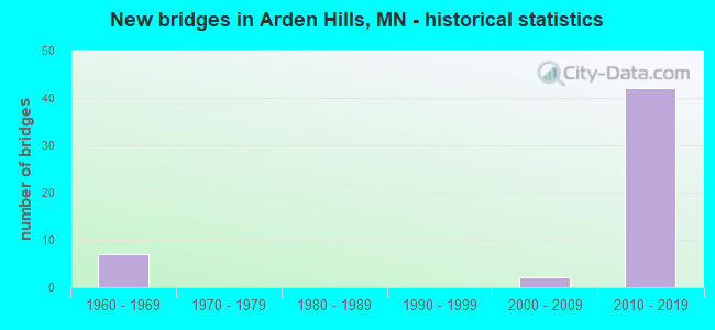
- New bridges - historical statistics
- 71960-1969
- 22000-2009
- 422010-2019


- Bridge Condition - Deck
- 54.5%Very good
- 45.5%Good

- Bridge Condition - Superstructure
- 68.2%Very good
- 18.2%Good
- 9.1%Satisfactory
- 4.5%Fair

- Bridge Condition - Substructure
- 27.3%Very good
- 50.0%Good
- 13.6%Satisfactory
- 9.1%Fair

- Bridge Condition - Channel
- 25.0%Very good
- 25.0%Good
- 50.0%Satisfactory

- Bridge Condition - Culverts
- 33.3%Very good
- 33.3%Good
- 33.3%Satisfactory
Find on map >> Show street view
Structure Number: 62038, Location: 0.9 MI S OF JCT TH 694 (Lat: 45.050228, Lng: -93.156808), Route carried "on" structure: County highway 15, Year Built: 2015, Status: Open, Structure Length: 5.61m (18.41ft), Average Daily Traffic: 15,400 (year 2016), Average Future Daily Traffic: 15,400 (year 2039), Design Load: HL 93, Features Intersected: TH 51 (SNELLING AVE)
Minimum Vertical Clearance: 30+ m (98+ ft), Kilometerpoint: 0.000, Lanes on structure: 2, Lanes under structure: 6, Owner: State Highway Agency, Approaching Roadway Width: 14.6m (47.9ft), Material/Design: Prestressed concrete, Design/Construction: Stringer/Multi-beam, Number Of Spans In Main Unit: 2, Length of Maximum Span: 27.7m (90.9ft), Curb or Sidewalk Widths: Left: 3.0m (9.8ft), Right: 0.0m, Curb-To-Curb Width: 14.6m (47.9ft), Out-to-Out Width: 18.6m (61.0ft)
Condition: Deck: Good, Superstructure: Very good, Substructure: Very good, Operating Rating: 57.7 metric tons, Method Used To Determine Operating Rating: Load and Resistance Factor Rating (LRFR) rating reported by rating factor(RF) method using HL-93 loadings, Inventory Rating: 36.9 metric tons, Method Used To Determine Inventory Rating: Load and Resistance Factor Rating (LRFR) rating reported by rating factor(RF) method using HL-93 loadings, Structural Evaluation: Equal to present desirable criteria, Deck Geometry: Superior to present desirable criteria, Underclear: Equal to present minimum criteria, Approach Roadway Alignment: Equal to present desirable criteria, Designated Inspection Frequency: Every 24 months, Inspection Date: August 2021, Deck Structure Type: Concrete Cast-file-Place, Wearing Surface/Protective System: Wearing Surface: Low Slump Concrete, Deck Protection: Epoxy Coated Reinforcing
Find on map >> Show street view
Structure Number: 62051, Location: AT THE JCT TH 694; 51 (Lat: 45.063356, Lng: -93.158219), Route carried "on" structure: Ramp State highway 197, Year Built: 2012, Status: Open, Structure Length: 4.37m (14.34ft), Average Daily Traffic: 16,000 (year 2016), Average Future Daily Traffic: 25,000 (year 2030), Design Load: HL 93, Features Intersected: I 694 WB
Minimum Vertical Clearance: 30+ m (98+ ft), Kilometerpoint: 0.000, Lanes on structure: 3, Lanes under structure: 4, Base Highway Network: Yes, Owner: State Highway Agency, Approaching Roadway Width: 18.9m (62.0ft), Skew: 32 degrees, Material/Design: Prestressed concrete, Design/Construction: Stringer/Multi-beam, Number Of Spans In Main Unit: 1, Length of Maximum Span: 43.7m (143.4ft), Curb-To-Curb Width: 18.9m (62.0ft), Out-to-Out Width: 20.6m (67.6ft)
Condition: Deck: Very good, Superstructure: Very good, Substructure: Satisfactory, Operating Rating: 89.3 metric tons, Method Used To Determine Operating Rating: Load Factor (LF), Inventory Rating: 42.9 metric tons, Method Used To Determine Inventory Rating: Load Factor (LF), Structural Evaluation: Equal to present minimum criteria, Deck Geometry: Superior to present desirable criteria, Underclear: Equal to present minimum criteria, Approach Roadway Alignment: Better than present minimum criteria, Designated Inspection Frequency: Every 24 months, Inspection Date: May 2020, Deck Structure Type: Concrete Cast-file-Place, Wearing Surface/Protective System: Wearing Surface: Monolithic Concrete, Deck Protection: Epoxy Coated Reinforcing
Find on map >> Show street view
Structure Number: 62052, Location: 0.47 MI E OF JCT TH694;10 (Lat: 45.061469, Lng: -93.158264), Route carried "on" structure: State highway 51, Year Built: 2012, Status: Open, Structure Length: 8.64m (28.35ft), Average Daily Traffic: 31,500 (year 2017), Truck Traffic: 8%, Average Future Daily Traffic: 31,500 (year 2039), Design Load: HL 93, Features Intersected: I 694; RAMP
Minimum Vertical Clearance: 30+ m (98+ ft), Kilometerpoint: 0.000, Lanes on structure: 3, Lanes under structure: 7, Owner: State Highway Agency, Approaching Roadway Width: 22.6m (74.1ft), Skew: 33 degrees, Material/Design: Prestressed concrete, Design/Construction: Stringer/Multi-beam, Number Of Spans In Main Unit: 2, Length of Maximum Span: 45.0m (147.6ft), Curb-To-Curb Width: 22.6m (74.1ft), Out-to-Out Width: 24.2m (79.4ft)
Condition: Deck: Very good, Superstructure: Very good, Substructure: Good, Operating Rating: 91.9 metric tons, Method Used To Determine Operating Rating: Load Factor (LF), Inventory Rating: 40.0 metric tons, Method Used To Determine Inventory Rating: Load Factor (LF), Structural Evaluation: Better than present minimum criteria, Deck Geometry: Superior to present desirable criteria, Underclear: Somewhat better than minimum adequacy, Approach Roadway Alignment: Equal to present desirable criteria, Designated Inspection Frequency: Every 24 months, Inspection Date: May 2020, Deck Structure Type: Concrete Cast-file-Place, Wearing Surface/Protective System: Wearing Surface: Monolithic Concrete, Deck Protection: Epoxy Coated Reinforcing
Find on map >> Show street view
Structure Number: 62057, Location: AT THE S JCT TH 10; 35W (Lat: 45.091836, Lng: -93.188164), Route carried "on" structure: Ramp Other road 10, Year Built: 2012, Status: Open, Structure Length: 12.45m (40.85ft), Average Daily Traffic: 11,550 (year 2014), Truck Traffic: 6%, Average Future Daily Traffic: 13,500 (year 2029), Design Load: HL 93, Features Intersected: I 35W; 35W SB OFF RAMP
Minimum Vertical Clearance: 30+ m (98+ ft), Kilometerpoint: 0.000, Lanes on structure: 2, Lanes under structure: 7, Owner: State Highway Agency, Approaching Roadway Width: 11.0m (36.1ft), Skew: 5 degrees, Material/Design: Concrete, Design/Construction: Stringer/Multi-beam, Number Of Spans In Main Unit: 4, Length of Maximum Span: 39.4m (129.3ft), Curb-To-Curb Width: 11.0m (36.1ft), Out-to-Out Width: 12.0m (39.4ft)
Condition: Deck: Very good, Superstructure: Good, Substructure: Good, Operating Rating: 68.0 metric tons, Method Used To Determine Operating Rating: Load and Resistance Factor Rating (LRFR) rating reported by rating factor(RF) method using HL-93 loadings, Inventory Rating: 40.2 metric tons, Method Used To Determine Inventory Rating: Load and Resistance Factor Rating (LRFR) rating reported by rating factor(RF) method using HL-93 loadings, Structural Evaluation: Better than present minimum criteria, Deck Geometry: Better than present minimum criteria, Underclear: Meets minimum limits, Approach Roadway Alignment: Equal to present desirable criteria, Designated Inspection Frequency: Every 24 months, Inspection Date: April 2020, Deck Structure Type: Concrete Cast-file-Place, Wearing Surface/Protective System: Wearing Surface: Low Slump Concrete, Deck Protection: Epoxy Coated Reinforcing
Find on map >> Show street view
Structure Number: 62058, Location: AT THE S JCT TH 10; 35W (Lat: 45.088622, Lng: -93.187967), Route carried "on" structure: US 10, Year Built: 2012, Status: Open, Structure Length: 15.23m (49.97ft), Average Daily Traffic: 26,399 (year 2019), Truck Traffic: 4%, Average Future Daily Traffic: 26,000 (year 2039), Design Load: HL 93, Features Intersected: I 35W; NB OFF RAMP
Minimum Vertical Clearance: 30+ m (98+ ft), Kilometerpoint: 0.000, Lanes on structure: 2, Lanes under structure: 7, Owner: State Highway Agency, Approaching Roadway Width: 14.0m (45.9ft), Skew: 6 degrees, Material/Design: Prestressed concrete, Design/Construction: Stringer/Multi-beam, Number Of Spans In Main Unit: 4, Length of Maximum Span: 46.3m (151.9ft), Curb-To-Curb Width: 14.0m (45.9ft), Out-to-Out Width: 15.0m (49.2ft)
Condition: Deck: Good, Superstructure: Very good, Substructure: Good, Operating Rating: 50.9 metric tons, Method Used To Determine Operating Rating: Load and Resistance Factor Rating (LRFR) rating reported by rating factor(RF) method using HL-93 loadings, Inventory Rating: 32.7 metric tons, Method Used To Determine Inventory Rating: Load and Resistance Factor Rating (LRFR) rating reported by rating factor(RF) method using HL-93 loadings, Structural Evaluation: Better than present minimum criteria, Deck Geometry: Superior to present desirable criteria, Underclear: Equal to present minimum criteria, Approach Roadway Alignment: Better than present minimum criteria, Designated Inspection Frequency: Every 24 months, Inspection Date: April 2020, Deck Structure Type: Concrete Cast-file-Place, Wearing Surface/Protective System: Wearing Surface: Low Slump Concrete, Deck Protection: Epoxy Coated Reinforcing
Find on map >> Show street view
Structure Number: 62071, Location: JCT OF US10 AND CSAH96 (Lat: 45.079250, Lng: -93.176614), Route carried "on" structure: US 10, Year Built: 2013, Status: Open, Structure Length: 8.35m (27.40ft), Average Daily Traffic: 19,918 (year 2019), Truck Traffic: 4%, Average Future Daily Traffic: 20,000 (year 2039), Design Load: HL 93, Features Intersected: CSAH 96
Minimum Vertical Clearance: 30+ m (98+ ft), Kilometerpoint: 0.000, Lanes on structure: 2, Lanes under structure: 4, Owner: State Highway Agency, Approaching Roadway Width: 11.6m (38.1ft), Skew: 4 degrees, Material/Design: Prestressed concrete, Design/Construction: Stringer/Multi-beam, Number Of Spans In Main Unit: 3, Length of Maximum Span: 42.8m (140.4ft), Curb-To-Curb Width: 12.9m (42.3ft), Out-to-Out Width: 13.9m (45.6ft)
Condition: Deck: Very good, Superstructure: Very good, Substructure: Good, Operating Rating: 58.3 metric tons, Method Used To Determine Operating Rating: Load and Resistance Factor Rating (LRFR) rating reported by rating factor(RF) method using HL-93 loadings, Inventory Rating: 40.8 metric tons, Method Used To Determine Inventory Rating: Load and Resistance Factor Rating (LRFR) rating reported by rating factor(RF) method using HL-93 loadings, Structural Evaluation: Better than present minimum criteria, Deck Geometry: Superior to present desirable criteria, Underclear: Meets minimum limits, Approach Roadway Alignment: Equal to present desirable criteria, Designated Inspection Frequency: Every 24 months, Inspection Date: May 2020, Deck Structure Type: Concrete Cast-file-Place, Wearing Surface/Protective System: Wearing Surface: Monolithic Concrete, Deck Protection: Epoxy Coated Reinforcing
Find on map >> Show street view
Structure Number: 62072, Location: AT JCT OF US10 AND CSAH96 (Lat: 45.079236, Lng: -93.176225), Route carried "on" structure: US 10, Year Built: 2013, Status: Open, Structure Length: 8.38m (27.49ft), Average Daily Traffic: 19,918 (year 2019), Truck Traffic: 4%, Average Future Daily Traffic: 20,000 (year 2039), Design Load: HL 93, Features Intersected: CSAH 96
Minimum Vertical Clearance: 30+ m (98+ ft), Kilometerpoint: 0.000, Lanes on structure: 2, Lanes under structure: 4, Owner: State Highway Agency, Approaching Roadway Width: 11.6m (38.1ft), Skew: 4 degrees, Material/Design: Prestressed concrete, Design/Construction: Stringer/Multi-beam, Number Of Spans In Main Unit: 3, Length of Maximum Span: 42.9m (140.7ft), Curb-To-Curb Width: 12.9m (42.3ft), Out-to-Out Width: 13.9m (45.6ft)
Condition: Deck: Very good, Superstructure: Very good, Substructure: Good, Operating Rating: 62.2 metric tons, Method Used To Determine Operating Rating: Load and Resistance Factor Rating (LRFR) rating reported by rating factor(RF) method using HL-93 loadings, Inventory Rating: 40.8 metric tons, Method Used To Determine Inventory Rating: Load and Resistance Factor Rating (LRFR) rating reported by rating factor(RF) method using HL-93 loadings, Structural Evaluation: Better than present minimum criteria, Deck Geometry: Superior to present desirable criteria, Underclear: Meets minimum limits, Approach Roadway Alignment: Equal to present desirable criteria, Designated Inspection Frequency: Every 24 months, Inspection Date: May 2020, Deck Structure Type: Concrete Cast-file-Place, Wearing Surface/Protective System: Wearing Surface: Monolithic Concrete, Deck Protection: Epoxy Coated Reinforcing
Find on map >> Show street view
Structure Number: 62539, Location: 0.2 Mmi E of jct TH 35W (Lat: 45.107997, Lng: -93.185333), Route carried "on" structure: County highway 3, Year Built: 2000, Status: Open, Structure Length: 1.56m (5.12ft), Average Daily Traffic: 7,800 (year 2017), Average Future Daily Traffic: 7,800 (year 2039), Design Load: HS 25 or greater, Features Intersected: Rice Creek
Minimum Vertical Clearance: 30+ m (98+ ft), Kilometerpoint: 0.000, Lanes on structure: 2, Owner: County Highway Agency, Approaching Roadway Width: 17.1m (56.1ft), Material/Design: Prestressed concrete, Design/Construction: Stringer/Multi-beam, Number Of Spans In Main Unit: 1, Length of Maximum Span: 15.0m (49.2ft), Curb or Sidewalk Widths: Left: 3.7m (12.1ft), Right: 0.0m, Curb-To-Curb Width: 17.1m (56.1ft), Out-to-Out Width: 17.1m (56.1ft)
Condition: Deck: Good, Superstructure: Very good, Substructure: Very good, Channel: Satisfactory, Operating Rating: 73.5 metric tons, Method Used To Determine Operating Rating: Load Factor (LF), Inventory Rating: 44.7 metric tons, Method Used To Determine Inventory Rating: Load Factor (LF), Structural Evaluation: Equal to present desirable criteria, Deck Geometry: Superior to present desirable criteria, Waterway Adequacy: Equal to present desirable criteria, Approach Roadway Alignment: Equal to present desirable criteria, Designated Inspection Frequency: Every 24 months, Inspection Date: November 2020, Deck Structure Type: Concrete Cast-file-Place, Wearing Surface/Protective System: Wearing Surface: Low Slump Concrete, Deck Protection: Epoxy Coated Reinforcing
Find on map >> Show street view
Structure Number: 62569, Location: 0.5 MI S OF JCT CSAH 73 (Lat: 45.050372, Lng: -93.187775), Route carried "on" structure: County highway 46, Year Built: 2001, Status: Open, Structure Length: 1.43m (4.69ft), Average Daily Traffic: 2,650 (year 2014), Average Future Daily Traffic: 2,650 (year 2039), Design Load: HS 25 or greater, Features Intersected: CP RAIL
Minimum Vertical Clearance: 30+ m (98+ ft), Kilometerpoint: 0.000, Lanes on structure: 2, Owner: County Highway Agency, Approaching Roadway Width: 12.2m (40.0ft), Material/Design: Concrete continuous, Design/Construction: Slab, Number Of Spans In Main Unit: 1, Length of Maximum Span: 12.5m (41.0ft), Curb or Sidewalk Widths: Left: 0.0m, Right: 2.0m (6.6ft), Curb-To-Curb Width: 12.0m (39.4ft), Out-to-Out Width: 14.9m (48.9ft)
Condition: Deck: Good, Superstructure: Good, Substructure: Good, Operating Rating: 76.1 metric tons, Method Used To Determine Operating Rating: Load Factor (LF), Inventory Rating: 45.4 metric tons, Method Used To Determine Inventory Rating: Load Factor (LF), Structural Evaluation: Better than present minimum criteria, Deck Geometry: Somewhat better than minimum adequacy, Underclear: Equal to present minimum criteria, Approach Roadway Alignment: Better than present minimum criteria, Designated Inspection Frequency: Every 24 months, Inspection Date: October 2020, Deck Structure Type: Concrete Cast-file-Place, Wearing Surface/Protective System: Wearing Surface: Bituminous, Deck Protection: Epoxy Coated Reinforcing
Find on map >> Show street view
Structure Number: 62716, Location: 0.2 MI W OF JCT TH 10 (Lat: 45.066781, Lng: -93.169747), Route carried "on" structure: Interstate 694, Year Built: 2013, Status: Open, Structure Length: 3.51m (11.52ft), Average Daily Traffic: 41,500 (year 2017), Truck Traffic: 2%, Average Future Daily Traffic: 41,500 (year 2039), Design Load: HL 93, Features Intersected: CSAH 76
Minimum Vertical Clearance: 30+ m (98+ ft), Kilometerpoint: 0.000, Lanes on structure: 3, Lanes under structure: 2, Base Highway Network: Yes, Owner: State Highway Agency, Approaching Roadway Width: 15.9m (52.2ft), Skew: 1 degrees, Material/Design: Prestressed concrete, Design/Construction: Stringer/Multi-beam, Number Of Spans In Main Unit: 1, Length of Maximum Span: 35.1m (115.2ft), Curb-To-Curb Width: 15.9m (52.2ft), Out-to-Out Width: 16.9m (55.4ft)
Condition: Deck: Very good, Superstructure: Good, Substructure: Fair, Operating Rating: 77.5 metric tons, Method Used To Determine Operating Rating: Load Factor (LF), Inventory Rating: 46.2 metric tons, Method Used To Determine Inventory Rating: Load Factor (LF), Structural Evaluation: Somewhat better than minimum adequacy, Deck Geometry: Somewhat better than minimum adequacy, Underclear: Somewhat better than minimum adequacy, Approach Roadway Alignment: Equal to present desirable criteria, Designated Inspection Frequency: Every 24 months, Inspection Date: May 2020, Deck Structure Type: Concrete Cast-file-Place, Wearing Surface/Protective System: Wearing Surface: Low Slump Concrete, Deck Protection: Other Coated Reinforcing
Find on map >> Show street view
Structure Number: 62717, Location: 0.2 MI W OF JCT TH 10 (Lat: 45.066478, Lng: -93.169722), Route carried "on" structure: Interstate 694, Year Built: 2012, Status: Open, Structure Length: 3.34m (10.96ft), Average Daily Traffic: 45,500 (year 2019), Truck Traffic: 9%, Average Future Daily Traffic: 41,500 (year 2039), Design Load: HL 93, Features Intersected: CSAH 76
Minimum Vertical Clearance: 30+ m (98+ ft), Kilometerpoint: 0.000, Lanes on structure: 3, Lanes under structure: 2, Base Highway Network: Yes, Owner: State Highway Agency, Approaching Roadway Width: 20.6m (67.6ft), Material/Design: Prestressed concrete, Design/Construction: Stringer/Multi-beam, Number Of Spans In Main Unit: 1, Length of Maximum Span: 33.4m (109.6ft), Curb-To-Curb Width: 20.6m (67.6ft), Out-to-Out Width: 21.5m (70.5ft)
Condition: Deck: Good, Superstructure: Very good, Substructure: Good, Operating Rating: 89.4 metric tons, Method Used To Determine Operating Rating: Load Factor (LF), Inventory Rating: 51.1 metric tons, Method Used To Determine Inventory Rating: Load Factor (LF), Structural Evaluation: Better than present minimum criteria, Deck Geometry: Superior to present desirable criteria, Underclear: Somewhat better than minimum adequacy, Approach Roadway Alignment: Equal to present desirable criteria, Designated Inspection Frequency: Every 24 months, Inspection Date: May 2020, Deck Structure Type: Concrete Cast-file-Place, Wearing Surface/Protective System: Wearing Surface: Low Slump Concrete, Deck Protection: Epoxy Coated Reinforcing
Find on map >> Show street view
Structure Number: 62719, Location: AT THE JCT TH 694; 10 (Lat: 45.066361, Lng: -93.166153), Route carried "on" structure: Interstate 694, Year Built: 2013, Status: Open, Structure Length: 8.83m (28.97ft), Average Daily Traffic: 33,000 (year 2017), Truck Traffic: 17%, Average Future Daily Traffic: 33,000 (year 2039), Design Load: HL 93, Features Intersected: US 10 SB
Minimum Vertical Clearance: 30+ m (98+ ft), Kilometerpoint: 0.000, Lanes on structure: 3, Lanes under structure: 2, Base Highway Network: Yes, Owner: State Highway Agency, Approaching Roadway Width: 19.4m (63.6ft), Skew: 4 degrees, Material/Design: Prestressed concrete, Design/Construction: Stringer/Multi-beam, Number Of Spans In Main Unit: 3, Length of Maximum Span: 38.8m (127.3ft), Curb-To-Curb Width: 17.1m (56.1ft), Out-to-Out Width: 19.4m (63.6ft)
Condition: Deck: Very good, Superstructure: Very good, Substructure: Satisfactory, Operating Rating: 68.6 metric tons, Method Used To Determine Operating Rating: Load Factor (LF), Inventory Rating: 41.0 metric tons, Method Used To Determine Inventory Rating: Load Factor (LF), Structural Evaluation: Equal to present minimum criteria, Deck Geometry: Equal to present minimum criteria, Underclear: Equal to present minimum criteria, Approach Roadway Alignment: Equal to present desirable criteria, Designated Inspection Frequency: Every 24 months, Inspection Date: May 2020, Deck Structure Type: Concrete Cast-file-Place, Wearing Surface/Protective System: Wearing Surface: Low Slump Concrete, Deck Protection: Epoxy Coated Reinforcing
Find on map >> Show street view
Structure Number: 6272, Location: AT THE JCT TH 694; 10 (Lat: 45.066064, Lng: -93.165969), Route carried "on" structure: Interstate 694, Year Built: 2012, Status: Open, Structure Length: 9.32m (30.58ft), Average Daily Traffic: 34,500 (year 2019), Truck Traffic: 10%, Average Future Daily Traffic: 33,000 (year 2039), Design Load: HL 93, Features Intersected: US 10 SB
Minimum Vertical Clearance: 30+ m (98+ ft), Kilometerpoint: 0.000, Lanes on structure: 2, Lanes under structure: 2, Base Highway Network: Yes, Owner: State Highway Agency, Approaching Roadway Width: 11.6m (38.1ft), Skew: 5 degrees, Material/Design: Prestressed concrete, Design/Construction: Stringer/Multi-beam, Number Of Spans In Main Unit: 3, Length of Maximum Span: 42.5m (139.4ft), Curb-To-Curb Width: 12.2m (40.0ft), Out-to-Out Width: 13.2m (43.3ft)
Condition: Deck: Very good, Superstructure: Very good, Substructure: Good, Operating Rating: 71.4 metric tons, Method Used To Determine Operating Rating: Load Factor (LF), Inventory Rating: 42.8 metric tons, Method Used To Determine Inventory Rating: Load Factor (LF), Structural Evaluation: Better than present minimum criteria, Deck Geometry: Better than present minimum criteria, Underclear: Equal to present minimum criteria, Approach Roadway Alignment: Equal to present desirable criteria, Designated Inspection Frequency: Every 24 months, Inspection Date: May 2020, Deck Structure Type: Concrete Cast-file-Place, Wearing Surface/Protective System: Wearing Surface: Low Slump Concrete, Deck Protection: Epoxy Coated Reinforcing
Find on map >> Show street view
Structure Number: 62732, Location: 0.4 Mi N of S Jct TH 10 (Lat: 45.095422, Lng: -93.188239), Route carried "on" structure: County highway 9, Year Built: 2016, Status: Open, Structure Length: 7.67m (25.16ft), Average Daily Traffic: 10,000 (year 2014), Average Future Daily Traffic: 24,900 (year 2036), Design Load: HL 93, Features Intersected: I 35W
Minimum Vertical Clearance: 30+ m (98+ ft), Kilometerpoint: 0.000, Lanes on structure: 4, Lanes under structure: 11, Owner: State Highway Agency, Approaching Roadway Width: 19.5m (64.0ft), Skew: 20 degrees, Material/Design: Prestressed concrete, Design/Construction: Stringer/Multi-beam, Number Of Spans In Main Unit: 2, Length of Maximum Span: 40.2m (131.9ft), Curb or Sidewalk Widths: Left: 0.0m, Right: 3.7m (12.1ft), Curb-To-Curb Width: 19.5m (64.0ft), Out-to-Out Width: 24.0m (78.7ft)
Condition: Deck: Very good, Superstructure: Very good, Substructure: Very good, Operating Rating: 70.6 metric tons, Method Used To Determine Operating Rating: Load and Resistance Factor Rating (LRFR) rating reported by rating factor(RF) method using HL-93 loadings, Inventory Rating: 42.4 metric tons, Method Used To Determine Inventory Rating: Load and Resistance Factor Rating (LRFR) rating reported by rating factor(RF) method using HL-93 loadings, Structural Evaluation: Equal to present desirable criteria, Deck Geometry: Better than present minimum criteria, Underclear: Equal to present minimum criteria, Approach Roadway Alignment: Better than present minimum criteria, Designated Inspection Frequency: Every 24 months, Inspection Date: April 2020, Deck Structure Type: Concrete Cast-file-Place, Wearing Surface/Protective System: Wearing Surface: Monolithic Concrete, Deck Protection: Epoxy Coated Reinforcing
Find on map >> Show street view
Structure Number: 62873, Location: 0.7 MI S OF JCT TH 694 (Lat: 45.057406, Lng: -93.187494), Route carried "on" structure: County highway 73, Year Built: 2016, Status: Open, Structure Length: 7.00m (22.97ft), Average Daily Traffic: 11,000 (year 2017), Average Future Daily Traffic: 11,000 (year 2039), Design Load: HL 93, Features Intersected: I 35W
Minimum Vertical Clearance: 30+ m (98+ ft), Kilometerpoint: 0.000, Lanes on structure: 2, Lanes under structure: 6, Owner: State Highway Agency, Approaching Roadway Width: 13.1m (43.0ft), Material/Design: Prestressed concrete, Design/Construction: Stringer/Multi-beam, Number Of Spans In Main Unit: 2, Length of Maximum Span: 34.9m (114.5ft), Curb or Sidewalk Widths: Left: 0.0m, Right: 3.0m (9.8ft), Curb-To-Curb Width: 13.1m (43.0ft), Out-to-Out Width: 17.0m (55.8ft)
Condition: Deck: Very good, Superstructure: Very good, Substructure: Good, Operating Rating: 42.8 metric tons, Method Used To Determine Operating Rating: Load and Resistance Factor Rating (LRFR) rating reported by rating factor(RF) method using HL-93 loadings, Inventory Rating: 33.0 metric tons, Method Used To Determine Inventory Rating: Load and Resistance Factor Rating (LRFR) rating reported by rating factor(RF) method using HL-93 loadings, Structural Evaluation: Better than present minimum criteria, Deck Geometry: Somewhat better than minimum adequacy, Underclear: Equal to present desirable criteria, Approach Roadway Alignment: Better than present minimum criteria, Designated Inspection Frequency: Every 24 months, Inspection Date: April 2020, Deck Structure Type: Concrete Cast-file-Place, Wearing Surface/Protective System: Wearing Surface: Monolithic Concrete, Deck Protection: Epoxy Coated Reinforcing
Find on map >> Show street view
Structure Number: 6289, Location: 0.2 MI S OF JCT TH 694 (Lat: 45.064686, Lng: -93.186347), Route carried "on" structure: City street 121, Year Built: 2015, Status: Open, Structure Length: 8.67m (28.44ft), Average Daily Traffic: 4,300 (year 2017), Average Future Daily Traffic: 4,300 (year 2039), Design Load: HL 93, Features Intersected: I 35W; I 35W SB ON RAMP
Minimum Vertical Clearance: 30+ m (98+ ft), Kilometerpoint: 0.000, Lanes on structure: 2, Lanes under structure: 8, Owner: State Highway Agency, Approaching Roadway Width: 10.7m (35.1ft), Material/Design: Prestressed concrete, Design/Construction: Stringer/Multi-beam, Number Of Spans In Main Unit: 2, Length of Maximum Span: 42.8m (140.4ft), Curb or Sidewalk Widths: Left: 0.0m, Right: 3.0m (9.8ft), Curb-To-Curb Width: 10.1m (33.1ft), Out-to-Out Width: 14.0m (45.9ft)
Condition: Deck: Very good, Superstructure: Good, Substructure: Very good, Operating Rating: 61.9 metric tons, Method Used To Determine Operating Rating: Load and Resistance Factor Rating (LRFR) rating reported by rating factor(RF) method using HL-93 loadings, Inventory Rating: 47.6 metric tons, Method Used To Determine Inventory Rating: Load and Resistance Factor Rating (LRFR) rating reported by rating factor(RF) method using HL-93 loadings, Structural Evaluation: Better than present minimum criteria, Deck Geometry: Meets minimum limits, Underclear: Better than present minimum criteria, Approach Roadway Alignment: Equal to present desirable criteria, Designated Inspection Frequency: Every 24 months, Inspection Date: April 2020, Deck Structure Type: Concrete Cast-file-Place, Wearing Surface/Protective System: Wearing Surface: Monolithic Concrete, Deck Protection: Epoxy Coated Reinforcing
Find on map >> Show street view
Structure Number: 62911, Location: 0.8 MI N OF JCT TH 694 (Lat: 45.079147, Lng: -93.185469), Route carried "on" structure: County highway 96, Year Built: 2015, Status: Open, Structure Length: 6.37m (20.90ft), Average Daily Traffic: 12,200 (year 2015), Average Future Daily Traffic: 12,200 (year 2039), Design Load: HL 93, Features Intersected: I 35W
Minimum Vertical Clearance: 30+ m (98+ ft), Kilometerpoint: 0.000, Lanes on structure: 5, Lanes under structure: 6, Owner: State Highway Agency, Approaching Roadway Width: 24.4m (80.1ft), Skew: 30 degrees, Material/Design: Prestressed concrete, Design/Construction: Stringer/Multi-beam, Number Of Spans In Main Unit: 2, Length of Maximum Span: 31.2m (102.4ft), Curb-To-Curb Width: 24.4m (80.1ft), Out-to-Out Width: 31.2m (102.4ft)
Condition: Deck: Good, Superstructure: Very good, Substructure: Very good, Operating Rating: 56.4 metric tons, Method Used To Determine Operating Rating: Load and Resistance Factor Rating (LRFR) rating reported by rating factor(RF) method using HL-93 loadings, Inventory Rating: 35.0 metric tons, Method Used To Determine Inventory Rating: Load and Resistance Factor Rating (LRFR) rating reported by rating factor(RF) method using HL-93 loadings, Structural Evaluation: Equal to present desirable criteria, Deck Geometry: Superior to present desirable criteria, Underclear: Better than present minimum criteria, Approach Roadway Alignment: Equal to present desirable criteria, Designated Inspection Frequency: Every 24 months, Inspection Date: July 2021, Deck Structure Type: Concrete Cast-file-Place, Wearing Surface/Protective System: Wearing Surface: Monolithic Concrete, Deck Protection: Epoxy Coated Reinforcing
Find on map >> Show street view
Structure Number: 62937, Location: 0.4 Mi N of S Jct TH 10 (Lat: 45.093117, Lng: -93.187836), Route carried "on" structure: US 10, Year Built: 2016, Status: Open, Structure Length: 8.28m (27.17ft), Average Daily Traffic: 61,500 (year 2017), Average Future Daily Traffic: 61,500 (year 2039), Design Load: HL 93, Features Intersected: I 35W NB
Minimum Vertical Clearance: 30+ m (98+ ft), Kilometerpoint: 0.000, Lanes on structure: 2, Lanes under structure: 1, Owner: State Highway Agency, Approaching Roadway Width: 11.6m (38.1ft), Skew: 3 degrees, Material/Design: Prestressed concrete, Design/Construction: Stringer/Multi-beam, Number Of Spans In Main Unit: 3, Length of Maximum Span: 33.5m (109.9ft), Curb-To-Curb Width: 11.6m (38.1ft), Out-to-Out Width: 12.6m (41.3ft)
Condition: Deck: Good, Superstructure: Very good, Substructure: Good, Operating Rating: 51.8 metric tons, Method Used To Determine Operating Rating: Load and Resistance Factor Rating (LRFR) rating reported by rating factor(RF) method using HL-93 loadings, Inventory Rating: 40.2 metric tons, Method Used To Determine Inventory Rating: Load and Resistance Factor Rating (LRFR) rating reported by rating factor(RF) method using HL-93 loadings, Structural Evaluation: Better than present minimum criteria, Deck Geometry: Better than present minimum criteria, Underclear: High priority of corrective action, Approach Roadway Alignment: Equal to present desirable criteria, Designated Inspection Frequency: Every 24 months, Inspection Date: April 2020, Deck Structure Type: Concrete Cast-file-Place, Wearing Surface/Protective System: Wearing Surface: Low Slump Concrete, Deck Protection: Epoxy Coated Reinforcing
Find on map >> Show street view
Structure Number: 62942, Location: 2.8 MI N OF JCT TH 694 (Lat: 45.107958, Lng: -93.188369), Route carried "on" structure: Interstate 35W, Year Built: 2019, Status: Open, Structure Length: 2.74m (8.99ft), Average Daily Traffic: 144,000 (year 2019), Truck Traffic: 5%, Average Future Daily Traffic: 144,000 (year 2039), Design Load: HL 93, Features Intersected: COUNTY RD I
Minimum Vertical Clearance: 30+ m (98+ ft), Kilometerpoint: 0.000, Lanes on structure: 12, Lanes under structure: 3, Base Highway Network: Yes, Owner: State Highway Agency, Approaching Roadway Width: 52.4m (171.9ft), Skew: 30 degrees, Material/Design: Prestressed concrete, Design/Construction: Stringer/Multi-beam, Number Of Spans In Main Unit: 1, Length of Maximum Span: 26.3m (86.3ft), Curb-To-Curb Width: 53.5m (175.5ft), Out-to-Out Width: 55.2m (181.1ft)
Condition: Deck: Very good, Superstructure: Very good, Substructure: Very good, Operating Rating: 52.8 metric tons, Method Used To Determine Operating Rating: Load and Resistance Factor Rating (LRFR) rating reported by rating factor(RF) method using HL-93 loadings, Inventory Rating: 40.8 metric tons, Method Used To Determine Inventory Rating: Load and Resistance Factor Rating (LRFR) rating reported by rating factor(RF) method using HL-93 loadings, Structural Evaluation: Equal to present desirable criteria, Deck Geometry: Superior to present desirable criteria, Underclear: Equal to present minimum criteria, Approach Roadway Alignment: Equal to present desirable criteria, Designated Inspection Frequency: Every 24 months, Inspection Date: November 2020, Deck Structure Type: Concrete Cast-file-Place, Wearing Surface/Protective System: Wearing Surface: Low Slump Concrete, Deck Protection: Epoxy Coated Reinforcing
Find on map >> Show street view
Structure Number: 62J17, Location: 0.1 MI N OF TH 51 (Lat: 45.039525, Lng: -93.160239), Route carried "on" structure: City street 111, Year Built: 2018, Status: Open, Structure Length: 0.67m (2.20ft), Average Daily Traffic: 1,600 (year 2017), Average Future Daily Traffic: 1,600 (year 2039), Design Load: HL 93, Features Intersected: CREEK
Minimum Vertical Clearance: 30+ m (98+ ft), Kilometerpoint: 0.000, Lanes on structure: 2, Owner: City or Municipal Highway Agency, Approaching Roadway Width: 12.2m (40.0ft), Material/Design: Concrete, Design/Construction: Culvert, Number Of Spans In Main Unit: 2, Length of Maximum Span: 3.1m (10.2ft)
Condition: Channel: Very good, Culverts: Very good, Operating Rating: 42.1 metric tons, Method Used To Determine Operating Rating: Assigned ratings based on Load and Resistance Factor Design (LRFD) reported by rating factor (RF) using HL93 loadings, Inventory Rating: 32.4 metric tons, Method Used To Determine Inventory Rating: Assigned ratings based on Load and Resistance Factor Design (LRFD) reported by rating factor (RF) using HL93 loadings, Structural Evaluation: Equal to present desirable criteria, Waterway Adequacy: Equal to present desirable criteria, Approach Roadway Alignment: Better than present minimum criteria, Designated Inspection Frequency: Every 24 months, Inspection Date: November 2021
Find on map >> Show street view
Structure Number: 62X04, Location: 1.1 MI N OF JCT CSAH 96 (Lat: 45.094672, Lng: -93.187050), Route carried "on" structure: Ramp Interstate 1972, Year Built: 2015, Status: Open, Structure Length: 0.66m (2.17ft), Average Daily Traffic: 1 (year 2015), Average Future Daily Traffic: 1 (year 2036), Design Load: HL 93, Features Intersected: RICE CREEK
Minimum Vertical Clearance: 30+ m (98+ ft), Kilometerpoint: 0.000, Lanes on structure: 2, Base Highway Network: Yes, Owner: State Highway Agency, Approaching Roadway Width: 8.5m (27.9ft), Material/Design: Concrete, Design/Construction: Culvert, Number Of Spans In Main Unit: 2, Length of Maximum Span: 3.0m (9.8ft)
Condition: Channel: Good, Culverts: Good, Operating Rating: 42.1 metric tons, Method Used To Determine Operating Rating: Load and Resistance Factor Rating (LRFR) rating reported by rating factor(RF) method using HL-93 loadings, Inventory Rating: 32.4 metric tons, Method Used To Determine Inventory Rating: Load and Resistance Factor Rating (LRFR) rating reported by rating factor(RF) method using HL-93 loadings, Structural Evaluation: Better than present minimum criteria, Waterway Adequacy: Equal to present desirable criteria, Approach Roadway Alignment: Equal to present desirable criteria, Designated Inspection Frequency: Every 48 months, Underwater Inspection Frequency: Every 60 months, Inspection Date: January 2019, Underwater Inspection Date: October 2020
Find on map >> Show street view
Structure Number: 91071, Location: 0.3 Mi N OF S JCT TH 10 (Lat: 45.094650, Lng: -93.188194), Route carried "on" structure: Interstate 35W, Year Built: 1963, Status: Open, Structure Length: 0.70m (2.30ft), Average Daily Traffic: 128,000 (year 2019), Truck Traffic: 5%, Average Future Daily Traffic: 123,000 (year 2039), Features Intersected: RICE CREEK
Minimum Vertical Clearance: 30+ m (98+ ft), Kilometerpoint: 0.000, Lanes on structure: 6, Base Highway Network: Yes, Owner: State Highway Agency, Approaching Roadway Width: 40.8m (133.9ft), Skew: 10 degrees, Material/Design: Concrete, Design/Construction: Culvert, Number Of Spans In Main Unit: 2, Length of Maximum Span: 3.2m (10.5ft)
Condition: Channel: Satisfactory, Culverts: Satisfactory, Operating Rating: 53.9 metric tons, Method Used To Determine Operating Rating: Assigned ratings based on Allowable Stress Design (ASD) reported in metric tons, Inventory Rating: 35.9 metric tons, Method Used To Determine Inventory Rating: Assigned ratings based on Allowable Stress Design (ASD) reported in metric tons, Structural Evaluation: Equal to present minimum criteria, Waterway Adequacy: Equal to present desirable criteria, Approach Roadway Alignment: Equal to present desirable criteria, Designated Inspection Frequency: Every 48 months, Underwater Inspection Frequency: Every 60 months, Inspection Date: April 2020, Underwater Inspection Date: October 2020
Find on map >> Show street view
Structure Number: 9578, Location: 1.2 MI N OF JCT TH 694 (Lat: 45.085217, Lng: -93.186761), Route carried "on" structure: , Year Built: 1963, Status: Open, Structure Length: 6.71m (22.01ft), Features Intersected: I 35W, Facility Carried by Structure: RAILROAD
Lanes under structure: 6, Owner: State Highway Agency, Skew: 1 degrees, Material/Design: Steel, Design/Construction: Girder and Floorbeam System, Number Of Spans In Main Unit: 4, Length of Maximum Span: 22.9m (75.1ft), Out-to-Out Width: 5.8m (19.0ft)
Condition: Deck: Good, Superstructure: Fair, Substructure: Good, Underclear: Somewhat better than minimum adequacy, Bridge Posting: Required (Relationship of Operating Rating to Maximum Legal Load: > 39.9% below), Designated Inspection Frequency: Every 12 months, Inspection Date: April 2021
Find on map >> Show street view
Structure Number: 9601, Location: AT THE JCT TH 694; 35W (Lat: 45.067233, Lng: -93.186042), Route carried "on" structure: Interstate 694, Year Built: 1963, Status: Open, Structure Length: 6.37m (20.90ft), Average Daily Traffic: 60,500 (year 2017), Truck Traffic: 8%, Average Future Daily Traffic: 60,500 (year 2039), Design Load: HS 20, Features Intersected: I 35W
Minimum Vertical Clearance: 30+ m (98+ ft), Kilometerpoint: 0.000, Lanes on structure: 4, Lanes under structure: 8, Base Highway Network: Yes, Owner: State Highway Agency, Approaching Roadway Width: 11.3m (37.1ft), Material/Design: Steel continuous, Design/Construction: Stringer/Multi-beam, Number Of Spans In Main Unit: 2, Length of Maximum Span: 31.2m (102.4ft), Curb-To-Curb Width: 16.5m (54.1ft), Out-to-Out Width: 17.5m (57.4ft)
Condition: Deck: Good, Superstructure: Satisfactory, Substructure: Satisfactory, Operating Rating: 56.1 metric tons, Method Used To Determine Operating Rating: Load Factor (LF), Inventory Rating: 33.7 metric tons, Method Used To Determine Inventory Rating: Load Factor (LF), Structural Evaluation: Equal to present minimum criteria, Deck Geometry: Meets minimum limits, Underclear: High priority of corrective action, Approach Roadway Alignment: Equal to present desirable criteria, Length Of Structure Improvement: 2.13m (6.99ft), Designated Inspection Frequency: Every 24 months, Inspection Date: July 2021, Bridge Improvement Cost: $999,999,000, Roadway Improvement Cost: $101,000,000, Total Project Cost: $999,999,000, Deck Structure Type: Concrete Cast-file-Place, Wearing Surface/Protective System: Wearing Surface: Other, Deck Protection: Epoxy Coated Reinforcing
Find on map >> Show street view
Structure Number: 9602, Location: AT THE JCT TH 694; 35W (Lat: 45.066994, Lng: -93.185997), Route carried "on" structure: Interstate 694, Year Built: 1963, Status: Open, Structure Length: 6.37m (20.90ft), Average Daily Traffic: 60,000 (year 2019), Truck Traffic: 8%, Average Future Daily Traffic: 60,500 (year 2039), Design Load: HS 20, Features Intersected: I 35W
Minimum Vertical Clearance: 30+ m (98+ ft), Kilometerpoint: 0.000, Lanes on structure: 4, Lanes under structure: 8, Base Highway Network: Yes, Owner: State Highway Agency, Approaching Roadway Width: 11.3m (37.1ft), Material/Design: Steel continuous, Design/Construction: Stringer/Multi-beam, Number Of Spans In Main Unit: 2, Length of Maximum Span: 31.2m (102.4ft), Curb-To-Curb Width: 16.5m (54.1ft), Out-to-Out Width: 17.5m (57.4ft)
Condition: Deck: Good, Superstructure: Satisfactory, Substructure: Fair, Operating Rating: 57.3 metric tons, Method Used To Determine Operating Rating: Load Factor (LF), Inventory Rating: 34.3 metric tons, Method Used To Determine Inventory Rating: Load Factor (LF), Structural Evaluation: Somewhat better than minimum adequacy, Deck Geometry: Meets minimum limits, Underclear: High priority of corrective action, Approach Roadway Alignment: Equal to present desirable criteria, Length Of Structure Improvement: 2.13m (6.99ft), Designated Inspection Frequency: Every 24 months, Inspection Date: July 2021, Bridge Improvement Cost: $999,999,000, Roadway Improvement Cost: $101,000,000, Total Project Cost: $999,999,000, Deck Structure Type: Concrete Cast-file-Place, Wearing Surface/Protective System: Wearing Surface: Low Slump Concrete, Deck Protection: Epoxy Coated Reinforcing
Find on map >> Show street view
Structure Number: 62038, Location: 0.9 MI S OF JCT TH 694 (Lat: 45.050228, Lng: -93.156808), Route carried "under" structure: State highway 51, Year Built: 2015, Structure Length: 0. m, Average Daily Traffic: 30,500 (year 2019), Truck Traffic: 2%, Features Intersected: TH 51 (SNELLING AVE), Facility Carried by Structure: CSAH 15
Minimum Vertical Clearance: 5.03m (16.50ft), Kilometerpoint: 0.000, Lanes under structure: 6, Material/Design: Prestressed concrete, Design/Construction: Stringer/Multi-beam, Length of Maximum Span: 27.7m (90.9ft)
Find on map >> Show street view
Structure Number: 62051, Location: AT THE JCT TH 694; 51 (Lat: 45.063356, Lng: -93.158219), Route carried "under" structure: Ramp US 4617, Year Built: 2012, Structure Length: 0. m, Average Daily Traffic: 1 (year 2021), Features Intersected: I 694 WB, Facility Carried by Structure: CON 197
Minimum Vertical Clearance: 5.03m (16.50ft), Kilometerpoint: 0.000, Lanes under structure: 1, Material/Design: Prestressed concrete, Design/Construction: Stringer/Multi-beam, Length of Maximum Span: 43.7m (143.4ft)
Find on map >> Show street view
Structure Number: 62051, Location: AT THE JCT TH 694; 51 (Lat: 45.063356, Lng: -93.158219), Route carried "under" structure: US 10, Year Built: 2012, Structure Length: 0. m, Average Daily Traffic: 57,000 (year 2012), Truck Traffic: 8%, Features Intersected: I 694 WB, Facility Carried by Structure: CON 197
Minimum Vertical Clearance: 5.03m (16.50ft), Kilometerpoint: 0.000, Lanes under structure: 3, Material/Design: Prestressed concrete, Design/Construction: Stringer/Multi-beam, Length of Maximum Span: 43.7m (143.4ft)
Find on map >> Show street view
Structure Number: 62052, Location: 0.47 MI E OF JCT TH694;10 (Lat: 45.061469, Lng: -93.158264), Route carried "under" structure: Interstate 694, Year Built: 2012, Structure Length: 0. m, Average Daily Traffic: 85,000 (year 2019), Truck Traffic: 9%, Features Intersected: I 694; RAMP, Facility Carried by Structure: MN 51
Minimum Vertical Clearance: 6.89m (22.60ft), Kilometerpoint: 0.000, Lanes under structure: 7, Material/Design: Prestressed concrete, Design/Construction: Stringer/Multi-beam, Length of Maximum Span: 45.0m (147.6ft)
Find on map >> Show street view
Structure Number: 62052, Location: 0.47 MI E OF JCT TH694;10 (Lat: 45.061469, Lng: -93.158264), Route carried "under" structure: Ramp Interstate 31, Year Built: 2012, Structure Length: 0. m, Average Daily Traffic: 1 (year 2021), Features Intersected: I 694; RAMP, Facility Carried by Structure: MN 51
Minimum Vertical Clearance: 6.92m (22.70ft), Kilometerpoint: 0.000, Lanes under structure: 1, Material/Design: Prestressed concrete, Design/Construction: Stringer/Multi-beam, Length of Maximum Span: 45.0m (147.6ft)
Find on map >> Show street view
Structure Number: 62057, Location: AT THE S JCT TH 10; 35W (Lat: 45.091836, Lng: -93.188164), Route carried "under" structure: Interstate 35W, Year Built: 2012, Structure Length: 0. m, Average Daily Traffic: 128,000 (year 2019), Truck Traffic: 5%, Features Intersected: I 35W; 35W SB OFF RAMP, Facility Carried by Structure: UNU 10
Minimum Vertical Clearance: 5.24m (17.19ft), Kilometerpoint: 0.000, Lanes under structure: 6, Material/Design: Concrete, Design/Construction: Stringer/Multi-beam, Length of Maximum Span: 39.4m (129.3ft)
Find on map >> Show street view
Structure Number: 62057, Location: AT THE S JCT TH 10; 35W (Lat: 45.091836, Lng: -93.188164), Route carried "under" structure: US 10, Year Built: 2012, Structure Length: 0. m, Average Daily Traffic: 26,399 (year 2019), Truck Traffic: 4%, Features Intersected: I 35W; 35W SB OFF RAMP
Minimum Vertical Clearance: 5.79m (19.00ft), Kilometerpoint: 0.000, Lanes under structure: 1, Material/Design: Concrete, Design/Construction: Stringer/Multi-beam, Length of Maximum Span: 39.4m (129.3ft)
Find on map >> Show street view
Structure Number: 62058, Location: AT THE S JCT TH 10; 35W (Lat: 45.088622, Lng: -93.187967), Route carried "under" structure: Interstate 35W, Year Built: 2012, Structure Length: 0. m, Average Daily Traffic: 128,000 (year 2019), Truck Traffic: 5%, Features Intersected: I 35W; NB OFF RAMP, Facility Carried by Structure: US 10
Minimum Vertical Clearance: 5.06m (16.60ft), Kilometerpoint: 0.000, Lanes under structure: 6, Material/Design: Prestressed concrete, Design/Construction: Stringer/Multi-beam, Length of Maximum Span: 46.3m (151.9ft)
Find on map >> Show street view
Structure Number: 62058, Location: AT THE S JCT TH 10; 35W (Lat: 45.088622, Lng: -93.187967), Route carried "under" structure: US 10, Year Built: 2012, Structure Length: 0. m, Average Daily Traffic: 5,000 (year 2012), Features Intersected: I 35W; NB OFF RAMP
Minimum Vertical Clearance: 5.61m (18.41ft), Kilometerpoint: 0.000, Lanes under structure: 1, Material/Design: Prestressed concrete, Design/Construction: Stringer/Multi-beam, Length of Maximum Span: 46.3m (151.9ft)
Find on map >> Show street view
Structure Number: 62071, Location: JCT OF US10 AND CSAH96 (Lat: 45.079250, Lng: -93.176614), Route carried "under" structure: County highway 96, Year Built: 2013, Structure Length: 0. m, Average Daily Traffic: 20,900 (year 2011), Features Intersected: CSAH 96, Facility Carried by Structure: US 10
Minimum Vertical Clearance: 5.21m (17.09ft), Kilometerpoint: 0.000, Lanes under structure: 4, Material/Design: Prestressed concrete, Design/Construction: Stringer/Multi-beam, Length of Maximum Span: 42.8m (140.4ft)
Find on map >> Show street view
Structure Number: 62072, Location: AT JCT OF US10 AND CSAH96 (Lat: 45.079236, Lng: -93.176225), Route carried "under" structure: County highway 96, Year Built: 2013, Structure Length: 0. m, Average Daily Traffic: 20,900 (year 2011), Features Intersected: CSAH 96, Facility Carried by Structure: US 10
Minimum Vertical Clearance: 5.06m (16.60ft), Kilometerpoint: 0.000, Lanes under structure: 4, Material/Design: Prestressed concrete, Design/Construction: Stringer/Multi-beam, Length of Maximum Span: 42.9m (140.7ft)
Find on map >> Show street view
Structure Number: 62716, Location: 0.2 MI W OF JCT TH 10 (Lat: 45.066781, Lng: -93.169747), Route carried "under" structure: County highway 76, Year Built: 2013, Structure Length: 0. m, Average Daily Traffic: 3,400 (year 2019), Truck Traffic: 8%, Features Intersected: CSAH 76, Facility Carried by Structure: I 694
Minimum Vertical Clearance: 5.12m (16.80ft), Kilometerpoint: 0.000, Lanes under structure: 2, Material/Design: Prestressed concrete, Design/Construction: Stringer/Multi-beam, Length of Maximum Span: 35.1m (115.2ft)
Find on map >> Show street view
Structure Number: 62717, Location: 0.2 MI W OF JCT TH 10 (Lat: 45.066478, Lng: -93.169722), Route carried "under" structure: County highway 76, Year Built: 2012, Structure Length: 0. m, Average Daily Traffic: 3,400 (year 2019), Truck Traffic: 8%, Features Intersected: CSAH 76, Facility Carried by Structure: I 694
Minimum Vertical Clearance: 4.85m (15.91ft), Kilometerpoint: 0.000, Lanes under structure: 2, Material/Design: Prestressed concrete, Design/Construction: Stringer/Multi-beam, Length of Maximum Span: 33.4m (109.6ft)
Find on map >> Show street view
Structure Number: 62719, Location: AT THE JCT TH 694; 10 (Lat: 45.066361, Lng: -93.166153), Route carried "under" structure: US 10, Year Built: 2013, Structure Length: 0. m, Average Daily Traffic: 19,918 (year 2019), Truck Traffic: 4%, Features Intersected: US 10 SB, Facility Carried by Structure: I 694
Minimum Vertical Clearance: 6.95m (22.80ft), Kilometerpoint: 0.000, Lanes under structure: 2, Material/Design: Prestressed concrete, Design/Construction: Stringer/Multi-beam, Length of Maximum Span: 38.8m (127.3ft)
Find on map >> Show street view
Structure Number: 6272, Location: AT THE JCT TH 694; 10 (Lat: 45.066064, Lng: -93.165969), Route carried "under" structure: US 10, Year Built: 2012, Structure Length: 0. m, Average Daily Traffic: 19,918 (year 2019), Truck Traffic: 4%, Features Intersected: US 10 SB, Facility Carried by Structure: I 694
Minimum Vertical Clearance: 5.24m (17.19ft), Kilometerpoint: 0.000, Lanes under structure: 2, Material/Design: Prestressed concrete, Design/Construction: Stringer/Multi-beam, Length of Maximum Span: 42.5m (139.4ft)
Find on map >> Show street view
Structure Number: 62732, Location: 0.4 Mi N of S Jct TH 10 (Lat: 45.095422, Lng: -93.188239), Route carried "under" structure: Interstate 35W, Year Built: 2016, Structure Length: 0. m, Average Daily Traffic: 128,000 (year 2019), Truck Traffic: 5%, Features Intersected: I 35W, Facility Carried by Structure: CSAH 9
Minimum Vertical Clearance: 5.24m (17.19ft), Kilometerpoint: 0.000, Lanes under structure: 11, Material/Design: Prestressed concrete, Design/Construction: Stringer/Multi-beam, Length of Maximum Span: 40.2m (131.9ft)
Find on map >> Show street view
Structure Number: 62873, Location: 0.7 MI S OF JCT TH 694 (Lat: 45.057406, Lng: -93.187494), Route carried "under" structure: Interstate 35W, Year Built: 2016, Structure Length: 0. m, Average Daily Traffic: 104,161 (year 2019), Truck Traffic: 6%, Features Intersected: I 35W, Facility Carried by Structure: CSAH 73
Minimum Vertical Clearance: 5.21m (17.09ft), Kilometerpoint: 0.000, Lanes under structure: 6, Material/Design: Prestressed concrete, Design/Construction: Stringer/Multi-beam, Length of Maximum Span: 34.9m (114.5ft)
Find on map >> Show street view
Structure Number: 6289, Location: 0.2 MI S OF JCT TH 694 (Lat: 45.064686, Lng: -93.186347), Route carried "under" structure: Ramp Interstate 2043, Year Built: 2015, Structure Length: 0. m, Average Daily Traffic: 3,100 (year 2019), Truck Traffic: 1%, Features Intersected: I 35W; I 35W SB ON RAMP, Facility Carried by Structure: MSAS 121
Minimum Vertical Clearance: 5.33m (17.49ft), Kilometerpoint: 0.000, Lanes under structure: 1, Material/Design: Prestressed concrete, Design/Construction: Stringer/Multi-beam, Length of Maximum Span: 42.8m (140.4ft)
Find on map >> Show street view
Structure Number: 6289, Location: 0.2 MI S OF JCT TH 694 (Lat: 45.064686, Lng: -93.186347), Route carried "under" structure: Interstate 35W, Year Built: 2015, Structure Length: 0. m, Average Daily Traffic: 104,161 (year 2019), Truck Traffic: 6%, Features Intersected: I 35W; I 35W SB ON RAMP, Facility Carried by Structure: MSAS 121
Minimum Vertical Clearance: 5.33m (17.49ft), Kilometerpoint: 0.000, Lanes under structure: 8, Material/Design: Prestressed concrete, Design/Construction: Stringer/Multi-beam, Length of Maximum Span: 42.8m (140.4ft)
Find on map >> Show street view
Structure Number: 6289, Location: 0.2 MI S OF JCT TH 694 (Lat: 45.064686, Lng: -93.186347), Route carried "under" structure: Ramp Interstate 2923, Year Built: 2015, Structure Length: 0. m, Average Daily Traffic: 5,000 (year 1994), Features Intersected: I 35W; I 35W SB ON RAMP, Facility Carried by Structure: MSAS 121
Minimum Vertical Clearance: 4.66m (15.29ft), Kilometerpoint: 0.000, Material/Design: Prestressed concrete, Design/Construction: Stringer/Multi-beam, Length of Maximum Span: 42.8m (140.4ft)
Find on map >> Show street view
Structure Number: 62911, Location: 0.8 MI N OF JCT TH 694 (Lat: 45.079147, Lng: -93.185469), Route carried "under" structure: Interstate 35W, Year Built: 2015, Structure Length: 0. m, Average Daily Traffic: 89,000 (year 2019), Truck Traffic: 6%, Features Intersected: I 35W, Facility Carried by Structure: CSAH 96
Minimum Vertical Clearance: 5.27m (17.29ft), Kilometerpoint: 0.000, Lanes under structure: 6, Material/Design: Prestressed concrete, Design/Construction: Stringer/Multi-beam, Length of Maximum Span: 31.2m (102.4ft)
Find on map >> Show street view
Structure Number: 62937, Location: 0.4 Mi N of S Jct TH 10 (Lat: 45.093117, Lng: -93.187836), Route carried "under" structure: Ramp US 1972, Year Built: 2016, Structure Length: 0. m, Average Daily Traffic: 160,000 (year 2014), Features Intersected: I 35W NB, Facility Carried by Structure: US 10
Minimum Vertical Clearance: 4.97m (16.31ft), Kilometerpoint: 0.000, Lanes under structure: 1, Material/Design: Prestressed concrete, Design/Construction: Stringer/Multi-beam, Length of Maximum Span: 33.5m (109.9ft)
Find on map >> Show street view
Structure Number: 62942, Location: 2.8 MI N OF JCT TH 694 (Lat: 45.107958, Lng: -93.188369), Route carried "under" structure: County highway 3, Year Built: 2019, Structure Length: 0. m, Average Daily Traffic: 6,300 (year 2018), Features Intersected: COUNTY RD I
Minimum Vertical Clearance: 5.15m (16.90ft), Kilometerpoint: 0.000, Lanes under structure: 3, Material/Design: Prestressed concrete, Design/Construction: Stringer/Multi-beam, Length of Maximum Span: 26.3m (86.3ft)
Find on map >> Show street view
Structure Number: 9578, Location: 1.2 MI N OF JCT TH 694 (Lat: 45.085217, Lng: -93.186761), Route carried "under" structure: Interstate 35W, Year Built: 1963, Structure Length: 0. m, Average Daily Traffic: 89,000 (year 2019), Truck Traffic: 6%, Features Intersected: I 35W, Facility Carried by Structure: RAILROAD
Minimum Vertical Clearance: 4.97m (16.31ft), Kilometerpoint: 0.000, Lanes on structure: 6, Lanes under structure: 6, Material/Design: Steel, Design/Construction: Girder and Floorbeam System, Length of Maximum Span: 22.9m (75.1ft)
Find on map >> Show street view
Structure Number: 9601, Location: AT THE JCT TH 694; 35W (Lat: 45.067233, Lng: -93.186042), Route carried "under" structure: Interstate 35W, Year Built: 1963, Structure Length: 0. m, Average Daily Traffic: 104,161 (year 2019), Truck Traffic: 6%, Features Intersected: I 35W, Facility Carried by Structure: I 694
Minimum Vertical Clearance: 4.91m (16.11ft), Kilometerpoint: 0.000, Lanes on structure: 4, Lanes under structure: 8, Material/Design: Steel continuous, Design/Construction: Stringer/Multi-beam, Length of Maximum Span: 31.2m (102.4ft)
Find on map >> Show street view
Structure Number: 9602, Location: AT THE JCT TH 694; 35W (Lat: 45.066994, Lng: -93.185997), Route carried "under" structure: Interstate 35W, Year Built: 1963, Structure Length: 0. m, Average Daily Traffic: 106,145 (year 2019), Truck Traffic: 6%, Features Intersected: I 35W, Facility Carried by Structure: I 694
Minimum Vertical Clearance: 4.85m (15.91ft), Kilometerpoint: 0.000, Lanes on structure: 4, Lanes under structure: 8, Material/Design: Steel continuous, Design/Construction: Stringer/Multi-beam, Length of Maximum Span: 31.2m (102.4ft)