Bridge Statistics for Auburn, California (CA)
Condition, Traffic, Stress, Structural Evaluation, Project Costs
- National Bridge Inventory (NBI) Statistics
- 29Number of bridges
- 253ft / 77.1mTotal length
- 789,499Total average daily traffic
- 68,654Total average daily truck traffic
- National Bridge Inventory (NBI) Registered Bridges for Auburn
- No street view available for this location
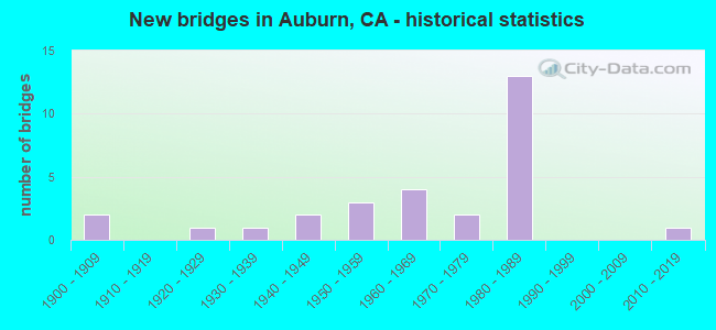
- New bridges - historical statistics
- 21900-1909
- 11920-1929
- 11930-1939
- 21940-1949
- 31950-1959
- 41960-1969
- 21970-1979
- 131980-1989
- 12010-2019

- Reconstructed bridges - Historical Statistics
- 11920-1929
- 01930-1939
- 01940-1949
- 01950-1959
- 01960-1969
- 21970-1979
- 51980-1989


- Bridge Condition - Deck
- 47.4%Good
- 31.6%Satisfactory
- 21.1%Fair

- Bridge Condition - Superstructure
- 57.9%Good
- 26.3%Satisfactory
- 15.8%Fair

- Bridge Condition - Substructure
- 52.6%Good
- 15.8%Satisfactory
- 31.6%Fair

- Bridge Condition - Channel
- 10.0%Excellent
- 30.0%Very good
- 20.0%Good
- 40.0%Satisfactory

- Bridge Condition - Culverts
- 33.3%Good
- 66.7%Satisfactory
Find on map >> Show street view
Structure Number: 19 004, Location: 03-PLA-080-45.71 (Lat: 39.204142, Lng: -120.795167), Route carried "on" structure: Interstate 80, Year Built: 1961, Year Reconstructed: 1991, Status: Open, Structure Length: 5.06m (16.60ft), Average Daily Traffic: 29,000 (year 2008), Truck Traffic: 16%, Average Future Daily Traffic: 36,373 (year 2041), Design Load: HS 20, Features Intersected: UP RR, BNSF RY, & AMTRAK
Minimum Vertical Clearance: 30+ m (98+ ft), Kilometerpoint: 45.710, Lanes on structure: 4, Base Highway Network: Yes (, Subroute: 2), Owner: State Highway Agency, Approaching Roadway Width: 26.8m (87.9ft), Skew: 30 degrees, Material/Design: Prestressed concrete, Design/Construction: Stringer/Multi-beam, Number Of Spans In Main Unit: 3, Length of Maximum Span: 16.8m (55.1ft), Curb-To-Curb Width: 26.8m (87.9ft), Out-to-Out Width: 28.4m (93.2ft)
Condition: Deck: Fair, Superstructure: Satisfactory, Substructure: Satisfactory, Operating Rating: 31.4 metric tons, Method Used To Determine Operating Rating: Load and Resistance Factor Rating (LRFR) rating reported by rating factor(RF) method using HL-93 loadings, Inventory Rating: 18.8 metric tons, Method Used To Determine Inventory Rating: Load and Resistance Factor Rating (LRFR) rating reported by rating factor(RF) method using HL-93 loadings, Structural Evaluation: Meets minimum limits, Deck Geometry: Superior to present desirable criteria, Underclear: Meets minimum limits, Approach Roadway Alignment: Better than present minimum criteria, Designated Inspection Frequency: Every 24 months, Inspection Date: June 2021, Deck Structure Type: Concrete Cast-file-Place, Wearing Surface/Protective System: Wearing Surface: Integral Concrete, Deck Protection: Epoxy Coated Reinforcing
Find on map >> Show street view
Structure Number: 19 006, Location: 03-PLA-080-17.83-AUB (Lat: 38.903367, Lng: -121.072225), Route carried "on" structure: City street , Year Built: 1989, Status: Open, Structure Length: 7.25m (23.79ft), Average Daily Traffic: 5,000 (year 1998), Truck Traffic: 5%, Average Future Daily Traffic: 15,820 (year 2039), Design Load: HS 20+Mod, Features Intersected: INTERSTATE 80, Facility Carried by Structure: ELM AVE
Minimum Vertical Clearance: 30+ m (98+ ft), Kilometerpoint: 0.000, Lanes on structure: 4, Lanes under structure: 10, Owner: State Highway Agency, Approaching Roadway Width: 19.5m (64.0ft), Skew: 1 degrees, Material/Design: Prestressed concrete continuous, Design/Construction: Box Beam or Girders - Multiple, Number Of Spans In Main Unit: 2, Length of Maximum Span: 38.1m (125.0ft), Curb or Sidewalk Widths: Left: 1.5m (4.9ft), Right: 1.5m (4.9ft), Curb-To-Curb Width: 19.5m (64.0ft), Out-to-Out Width: 23.1m (75.8ft)
Condition: Deck: Satisfactory, Superstructure: Satisfactory, Substructure: Good, Operating Rating: 54.1 metric tons, Method Used To Determine Operating Rating: Assigned rating based on Load Factor Design (LFD) reported in metric tons, Inventory Rating: 32.4 metric tons, Method Used To Determine Inventory Rating: Assigned rating based on Load Factor Design (LFD) reported in metric tons, Structural Evaluation: Equal to present minimum criteria, Deck Geometry: Better than present minimum criteria, Underclear: Somewhat better than minimum adequacy, Approach Roadway Alignment: Equal to present desirable criteria, Designated Inspection Frequency: Every 24 months, Inspection Date: December 2021, Deck Structure Type: Concrete Cast-file-Place
Find on map >> Show street view
Structure Number: 19 0064, Location: 03-PLA-080-17.18 (Lat: 38.896156, Lng: -121.080231), Route carried "on" structure: Interstate 80, Year Built: 1932, Year Reconstructed: 1989, Status: Open, Structure Length: 0.91m (2.99ft), Average Daily Traffic: 59,000 (year 2009), Truck Traffic: 8%, Average Future Daily Traffic: 133,642 (year 2039), Features Intersected: AUBURN RAVINE, SPRING CR
Minimum Vertical Clearance: 30+ m (98+ ft), Kilometerpoint: 17.180, Lanes on structure: 8, Base Highway Network: Yes (, Subroute: 2), Owner: State Highway Agency, Approaching Roadway Width: 43.9m (144.0ft), Skew: 33 degrees, Material/Design: Concrete, Design/Construction: Culvert, Number Of Spans In Main Unit: 1, Length of Maximum Span: 9.1m (29.9ft)
Condition: Channel: Satisfactory, Culverts: Satisfactory, Operating Rating: 40.5 metric tons, Method Used To Determine Operating Rating: Field evaluation and documented engineering judgment, Inventory Rating: 24.3 metric tons, Method Used To Determine Inventory Rating: Field evaluation and documented engineering judgment, Structural Evaluation: Equal to present minimum criteria, Waterway Adequacy: Equal to present desirable criteria, Approach Roadway Alignment: Equal to present desirable criteria, Designated Inspection Frequency: Every 24 months, Inspection Date: October 2021
Find on map >> Show street view
Structure Number: 19 0071, Location: 03-PLA-080-18.33-AUB (Lat: 38.909828, Lng: -121.069169), Route carried "on" structure: Interstate 80, Year Built: 1989, Status: Open, Structure Length: 7.83m (25.69ft), Average Daily Traffic: 59,000 (year 2009), Truck Traffic: 8%, Average Future Daily Traffic: 136,337 (year 2039), Design Load: HS 20+Mod, Features Intersected: UP RR, BNSF RY, & AMTRAK
Minimum Vertical Clearance: 30+ m (98+ ft), Kilometerpoint: 18.330, Lanes on structure: 7, Base Highway Network: Yes (, Subroute: 2), Owner: State Highway Agency, Approaching Roadway Width: 37.3m (122.4ft), Skew: 34 degrees, Material/Design: Prestressed concrete continuous, Design/Construction: Box Beam or Girders - Multiple, Number Of Spans In Main Unit: 2, Length of Maximum Span: 46.3m (151.9ft), Curb-To-Curb Width: 37.3m (122.4ft), Out-to-Out Width: 39.0m (128.0ft)
Condition: Deck: Satisfactory, Superstructure: Good, Substructure: Good, Operating Rating: 54.1 metric tons, Method Used To Determine Operating Rating: Assigned rating based on Load Factor Design (LFD) reported in metric tons, Inventory Rating: 32.4 metric tons, Method Used To Determine Inventory Rating: Assigned rating based on Load Factor Design (LFD) reported in metric tons, Structural Evaluation: Better than present minimum criteria, Deck Geometry: Superior to present desirable criteria, Underclear: Better than present minimum criteria, Approach Roadway Alignment: Equal to present desirable criteria, Designated Inspection Frequency: Every 24 months, Inspection Date: December 2021, Deck Structure Type: Concrete Cast-file-Place
Find on map >> Show street view
Structure Number: 19 0072, Location: 03-PLA-080-17.54-AUB (Lat: 38.899822, Lng: -121.074833), Route carried "on" structure: Interstate 80, Year Built: 1989, Status: Open, Structure Length: 5.97m (19.59ft), Average Daily Traffic: 59,000 (year 2009), Truck Traffic: 8%, Average Future Daily Traffic: 136,337 (year 2039), Design Load: HS 20+Mod, Features Intersected: SR 49 (GOLDEN CHAIN HWY)
Minimum Vertical Clearance: 30+ m (98+ ft), Kilometerpoint: 17.540, Lanes on structure: 8, Lanes under structure: 4, Base Highway Network: Yes (, Subroute: 2), Owner: State Highway Agency, Approaching Roadway Width: 41.0m (134.5ft), Skew: 32 degrees, Material/Design: Prestressed concrete continuous, Design/Construction: Box Beam or Girders - Multiple, Number Of Spans In Main Unit: 3, Length of Maximum Span: 33.5m (109.9ft), Curb-To-Curb Width: 41.0m (134.5ft), Out-to-Out Width: 42.6m (139.8ft)
Condition: Deck: Satisfactory, Superstructure: Good, Substructure: Satisfactory, Operating Rating: 54.1 metric tons, Method Used To Determine Operating Rating: Assigned rating based on Load Factor Design (LFD) reported in metric tons, Inventory Rating: 32.4 metric tons, Method Used To Determine Inventory Rating: Assigned rating based on Load Factor Design (LFD) reported in metric tons, Structural Evaluation: Equal to present minimum criteria, Deck Geometry: Superior to present desirable criteria, Underclear: Equal to present minimum criteria, Approach Roadway Alignment: Equal to present desirable criteria, Designated Inspection Frequency: Every 24 months, Inspection Date: December 2021, Deck Structure Type: Concrete Cast-file-Place
Find on map >> Show street view
Structure Number: 19 0073, Location: 03-PLA-080-17.73-AUB (Lat: 38.902053, Lng: -121.072358), Route carried "on" structure: Interstate 80, Year Built: 1946, Year Reconstructed: 1989, Status: Open, Structure Length: 2.63m (8.63ft), Average Daily Traffic: 59,000 (year 2009), Truck Traffic: 8%, Average Future Daily Traffic: 136,337 (year 2039), Design Load: HS 20, Features Intersected: WALSH ST
Minimum Vertical Clearance: 30+ m (98+ ft), Kilometerpoint: 17.730, Lanes on structure: 9, Lanes under structure: 2, Base Highway Network: Yes (, Subroute: 2), Owner: State Highway Agency, Approaching Roadway Width: 47.0m (154.2ft), Skew: 31 degrees, Material/Design: Concrete, Design/Construction: Slab, Number Of Spans In Main Unit: 3, Length of Maximum Span: 10.5m (34.4ft), Curb-To-Curb Width: 47.0m (154.2ft), Out-to-Out Width: 48.6m (159.4ft)
Condition: Deck: Satisfactory, Superstructure: Satisfactory, Substructure: Fair, Operating Rating: 54.1 metric tons, Method Used To Determine Operating Rating: Assigned rating based on Load Factor Design (LFD) reported in metric tons, Inventory Rating: 32.4 metric tons, Method Used To Determine Inventory Rating: Assigned rating based on Load Factor Design (LFD) reported in metric tons, Structural Evaluation: Somewhat better than minimum adequacy, Deck Geometry: Superior to present desirable criteria, Underclear: High priority of corrective action, Approach Roadway Alignment: Equal to present desirable criteria, Designated Inspection Frequency: Every 24 months, Inspection Date: December 2021, Deck Structure Type: Concrete Cast-file-Place, Wearing Surface/Protective System: Wearing Surface: Bituminous
Find on map >> Show street view
Structure Number: 19 0081, Location: 03-PLA-080-16.85-AUB (Lat: 38.892994, Lng: -121.083917), Route carried "on" structure: Interstate 80, Year Built: 1957, Year Reconstructed: 1975, Status: Open, Structure Length: 3.90m (12.80ft), Average Daily Traffic: 59,000 (year 2009), Truck Traffic: 8%, Average Future Daily Traffic: 133,642 (year 2039), Design Load: HS 20, Features Intersected: OPHIR ROAD-E80 ON RAMP
Minimum Vertical Clearance: 30+ m (98+ ft), Kilometerpoint: 16.850, Lanes on structure: 6, Lanes under structure: 7, Base Highway Network: Yes (, Subroute: 2), Owner: State Highway Agency, Approaching Roadway Width: 33.6m (110.2ft), Skew: 39 degrees, Material/Design: Concrete continuous, Design/Construction: Slab, Number Of Spans In Main Unit: 3, Length of Maximum Span: 15.2m (49.9ft), Curb-To-Curb Width: 33.6m (110.2ft), Out-to-Out Width: 35.3m (115.8ft)
Condition: Deck: Good, Superstructure: Satisfactory, Substructure: Good, Operating Rating: 88.1 metric tons, Method Used To Determine Operating Rating: Load Factor (LF), Inventory Rating: 53.1 metric tons, Method Used To Determine Inventory Rating: Load Factor (LF), Structural Evaluation: Equal to present minimum criteria, Deck Geometry: Superior to present desirable criteria, Underclear: High priority of corrective action, Approach Roadway Alignment: Equal to present desirable criteria, Designated Inspection Frequency: Every 24 months, Inspection Date: October 2021, Deck Structure Type: Concrete Cast-file-Place, Wearing Surface/Protective System: Wearing Surface: Integral Concrete
Find on map >> Show street view
Structure Number: 19 0084, Location: 03-PLA-080-17.29-AUB (Lat: 38.897572, Lng: -121.078456), Route carried "on" structure: City street , Year Built: 1989, Status: Open, Structure Length: 6.80m (22.31ft), Average Daily Traffic: 5,000 (year 1998), Truck Traffic: 5%, Average Future Daily Traffic: 15,456 (year 2039), Design Load: HS 20+Mod, Features Intersected: INTERSTATE 80, Facility Carried by Structure: MAPLE STREET
Minimum Vertical Clearance: 30+ m (98+ ft), Kilometerpoint: 0.000, Lanes on structure: 2, Lanes under structure: 8, Owner: State Highway Agency, Approaching Roadway Width: 9.9m (32.5ft), Material/Design: Prestressed concrete continuous, Design/Construction: Box Beam or Girders - Multiple, Number Of Spans In Main Unit: 2, Length of Maximum Span: 36.6m (120.1ft), Curb or Sidewalk Widths: Left: 1.5m (4.9ft), Right: 0.0m, Curb-To-Curb Width: 9.9m (32.5ft), Out-to-Out Width: 12.2m (40.0ft)
Condition: Deck: Fair, Superstructure: Good, Substructure: Fair, Operating Rating: 54.1 metric tons, Method Used To Determine Operating Rating: Assigned rating based on Load Factor Design (LFD) reported in metric tons, Inventory Rating: 32.4 metric tons, Method Used To Determine Inventory Rating: Assigned rating based on Load Factor Design (LFD) reported in metric tons, Structural Evaluation: Somewhat better than minimum adequacy, Deck Geometry: Meets minimum limits, Underclear: Somewhat better than minimum adequacy, Approach Roadway Alignment: Equal to present desirable criteria, Designated Inspection Frequency: Every 24 months, Inspection Date: October 2021, Deck Structure Type: Concrete Cast-file-Place
Find on map >> Show street view
Structure Number: 19 0120L, Location: 03-PLA-080-R64.21L (Lat: 39.305483, Lng: -120.532981), Route carried "on" structure: Interstate 80, Year Built: 1964, Year Reconstructed: 1989, Status: Open, Structure Length: 9.97m (32.71ft), Average Daily Traffic: 27,000 (year 2015), Truck Traffic: 10%, Average Future Daily Traffic: 40,000 (year 2040), Design Load: HS 20, Features Intersected: EAST CISCO ROAD
Minimum Vertical Clearance: 30+ m (98+ ft), Kilometerpoint: 64.210, Lanes on structure: 2, Lanes under structure: 2, Base Highway Network: Yes (, Subroute: 3), Owner: State Highway Agency, Approaching Roadway Width: 13.4m (44.0ft), Material/Design: Steel, Design/Construction: Stringer/Multi-beam, Number Of Spans In Main Unit: 3, Length of Maximum Span: 36.6m (120.1ft), Curb-To-Curb Width: 13.4m (44.0ft), Out-to-Out Width: 14.2m (46.6ft)
Condition: Deck: Good, Superstructure: Fair, Substructure: Fair, Operating Rating: 56.4 metric tons, Method Used To Determine Operating Rating: Load and Resistance Factor Rating (LRFR) rating reported by rating factor(RF) method using HL-93 loadings, Inventory Rating: 43.4 metric tons, Method Used To Determine Inventory Rating: Load and Resistance Factor Rating (LRFR) rating reported by rating factor(RF) method using HL-93 loadings, Structural Evaluation: Somewhat better than minimum adequacy, Deck Geometry: Superior to present desirable criteria, Underclear: Somewhat better than minimum adequacy, Approach Roadway Alignment: Equal to present desirable criteria, Designated Inspection Frequency: Every 24 months, Inspection Date: June 2020, Deck Structure Type: Concrete Cast-file-Place, Wearing Surface/Protective System: Wearing Surface: Integral Concrete, Deck Protection: Epoxy Coated Reinforcing
Find on map >> Show street view
Structure Number: 19 0125, Location: 03-PLA-080-R18.88-AUB (Lat: 38.916297, Lng: -121.063367), Route carried "on" structure: County highway , Year Built: 1988, Status: Open, Structure Length: 7.70m (25.26ft), Average Daily Traffic: 800 (year 1998), Truck Traffic: 5%, Average Future Daily Traffic: 3,165 (year 2039), Design Load: HS 20+Mod, Features Intersected: INTERSTATE 80, Facility Carried by Structure: RUSSELL ROAD
Minimum Vertical Clearance: 30+ m (98+ ft), Kilometerpoint: 0.000, Lanes on structure: 2, Lanes under structure: 7, Owner: State Highway Agency, Approaching Roadway Width: 9.8m (32.2ft), Skew: 2 degrees, Material/Design: Prestressed concrete continuous, Design/Construction: Box Beam or Girders - Multiple, Number Of Spans In Main Unit: 2, Length of Maximum Span: 43.9m (144.0ft), Curb or Sidewalk Widths: Left: 1.5m (4.9ft), Right: 0.0m, Curb-To-Curb Width: 9.8m (32.2ft), Out-to-Out Width: 12.0m (39.4ft)
Condition: Deck: Satisfactory, Superstructure: Good, Substructure: Satisfactory, Operating Rating: 54.1 metric tons, Method Used To Determine Operating Rating: Assigned rating based on Load Factor Design (LFD) reported in metric tons, Inventory Rating: 32.4 metric tons, Method Used To Determine Inventory Rating: Assigned rating based on Load Factor Design (LFD) reported in metric tons, Structural Evaluation: Equal to present minimum criteria, Deck Geometry: Equal to present minimum criteria, Underclear: Somewhat better than minimum adequacy, Approach Roadway Alignment: Equal to present desirable criteria, Designated Inspection Frequency: Every 24 months, Inspection Date: December 2021, Deck Structure Type: Concrete Cast-file-Place
Find on map >> Show street view
Structure Number: 19 0155, Location: 03-PLA-049-3.33-AUB (Lat: 38.902031, Lng: -121.075561), Route carried "on" structure: State highway 49, Year Built: 1989, Status: Open, Structure Length: 0.67m (2.20ft), Average Daily Traffic: 33,500 (year 2009), Truck Traffic: 3%, Average Future Daily Traffic: 58,700 (year 2041), Features Intersected: AUBURN RAVINE
Minimum Vertical Clearance: 30+ m (98+ ft), Kilometerpoint: 3.330, Lanes on structure: 4, Base Highway Network: Yes (, Subroute: 1), Owner: State Highway Agency, Approaching Roadway Width: 24.4m (80.1ft), Skew: 5 degrees, Material/Design: Concrete, Design/Construction: Frame, Number Of Spans In Main Unit: 1, Length of Maximum Span: 6.1m (20.0ft)
Condition: Deck: Good, Superstructure: Good, Substructure: Good, Channel: Very good, Operating Rating: 54.1 metric tons, Method Used To Determine Operating Rating: Field evaluation and documented engineering judgment, Inventory Rating: 32.4 metric tons, Method Used To Determine Inventory Rating: Field evaluation and documented engineering judgment, Structural Evaluation: Better than present minimum criteria, Waterway Adequacy: Equal to present desirable criteria, Approach Roadway Alignment: Equal to present desirable criteria, Designated Inspection Frequency: Every 48 months, Inspection Date: August 2021
Find on map >> Show street view
Structure Number: 19 0156E, Location: 03-PLA-080-17.49-AUB (Lat: 38.900244, Lng: -121.076094), Route carried "on" structure: Ramp Interstate 80, Year Built: 1989, Status: Open, Structure Length: 0.70m (2.30ft), Average Daily Traffic: 13,300 (year 2009), Truck Traffic: 7%, Average Future Daily Traffic: 11,323 (year 2039), Design Load: HS 20+Mod, Features Intersected: AUBURN RAVINE
Minimum Vertical Clearance: 30+ m (98+ ft), Kilometerpoint: 17.490, Lanes on structure: 2, Base Highway Network: Yes (, Subroute: 1), Owner: State Highway Agency, Approaching Roadway Width: 18.9m (62.0ft), Material/Design: Concrete, Design/Construction: Slab, Number Of Spans In Main Unit: 1, Length of Maximum Span: 6.1m (20.0ft)
Condition: Deck: Satisfactory, Superstructure: Satisfactory, Substructure: Good, Channel: Very good, Operating Rating: 54.1 metric tons, Method Used To Determine Operating Rating: Field evaluation and documented engineering judgment, Inventory Rating: 32.4 metric tons, Method Used To Determine Inventory Rating: Field evaluation and documented engineering judgment, Structural Evaluation: Equal to present minimum criteria, Waterway Adequacy: Equal to present desirable criteria, Approach Roadway Alignment: Equal to present desirable criteria, Designated Inspection Frequency: Every 24 months, Inspection Date: October 2021
Find on map >> Show street view
Structure Number: 19 0157E, Location: 03-PLA-049-3.25-AUB (Lat: 38.900592, Lng: -121.075411), Route carried "on" structure: Ramp State highway 49, Year Built: 1989, Status: Open, Structure Length: 0.67m (2.20ft), Average Daily Traffic: 13,300 (year 2006), Truck Traffic: 7%, Average Future Daily Traffic: 11,025 (year 2041), Features Intersected: AUBURN RAVINE
Minimum Vertical Clearance: 30+ m (98+ ft), Kilometerpoint: 3.250, Lanes on structure: 5, Owner: State Highway Agency, Approaching Roadway Width: 51.0m (167.3ft), Skew: 1 degrees, Material/Design: Concrete, Design/Construction: Frame, Number Of Spans In Main Unit: 1, Length of Maximum Span: 6.1m (20.0ft), Curb-To-Curb Width: 51.0m (167.3ft), Out-to-Out Width: 80.0m (262.5ft)
Condition: Deck: Good, Superstructure: Good, Substructure: Good, Channel: Very good, Operating Rating: 54.1 metric tons, Method Used To Determine Operating Rating: Field evaluation and documented engineering judgment, Inventory Rating: 32.4 metric tons, Method Used To Determine Inventory Rating: Field evaluation and documented engineering judgment, Structural Evaluation: Better than present minimum criteria, Deck Geometry: Superior to present desirable criteria, Waterway Adequacy: Equal to present desirable criteria, Approach Roadway Alignment: Equal to present desirable criteria, Designated Inspection Frequency: Every 48 months, Inspection Date: August 2021
Find on map >> Show street view
Structure Number: 19C0036, Location: JUNCT WITH OPHIR RD (Lat: 38.890575, Lng: -121.097064), Route carried "on" structure: County highway , Year Built: 1940, Year Reconstructed: 1970, Status: Open, Structure Length: 0.79m (2.59ft), Average Daily Traffic: 1,611 (year 2006), Truck Traffic: 2%, Average Future Daily Traffic: 2,828 (year 2043), Features Intersected: AUBURN RAVINE, Facility Carried by Structure: WISE RD
Minimum Vertical Clearance: 30+ m (98+ ft), Kilometerpoint: 0.000, Lanes on structure: 2, Owner: County Highway Agency, Approaching Roadway Width: 7.3m (24.0ft), Skew: 1 degrees, Material/Design: Concrete, Design/Construction: Stringer/Multi-beam, Number Of Spans In Main Unit: 1, Length of Maximum Span: 6.7m (22.0ft), Curb-To-Curb Width: 10.7m (35.1ft), Out-to-Out Width: 11.2m (36.7ft)
Condition: Deck: Good, Superstructure: Good, Substructure: Fair, Channel: Satisfactory, Operating Rating: 28.5 metric tons, Method Used To Determine Operating Rating: Field evaluation and documented engineering judgment, Inventory Rating: 17.2 metric tons, Method Used To Determine Inventory Rating: Field evaluation and documented engineering judgment, Structural Evaluation: Meets minimum limits, Deck Geometry: Equal to present minimum criteria, Waterway Adequacy: Equal to present minimum criteria, Approach Roadway Alignment: Equal to present minimum criteria, Designated Inspection Frequency: Every 24 months, Inspection Date: April 2021, Deck Structure Type: Concrete Cast-file-Place, Wearing Surface/Protective System: Wearing Surface: Bituminous
Find on map >> Show street view
Structure Number: 19C0039, Location: 2.0 MI E OF RTE 49 (Lat: 38.960681, Lng: -121.072442), Route carried "on" structure: County highway , Year Built: 1966, Status: Open, Structure Length: 0.82m (2.69ft), Average Daily Traffic: 3,401 (year 2007), Truck Traffic: 1%, Average Future Daily Traffic: 4,391 (year 2042), Features Intersected: SOUTH FORK DRY CREEK, Facility Carried by Structure: DRY CREEK RD
Minimum Vertical Clearance: 30+ m (98+ ft), Kilometerpoint: 0.000, Lanes on structure: 2, Owner: County Highway Agency, Approaching Roadway Width: 7.3m (24.0ft), Skew: 2 degrees, Material/Design: Concrete, Design/Construction: Slab, Number Of Spans In Main Unit: 1, Length of Maximum Span: 7.9m (25.9ft), Curb-To-Curb Width: 9.4m (30.8ft), Out-to-Out Width: 9.8m (32.2ft)
Condition: Deck: Good, Superstructure: Good, Substructure: Good, Channel: Satisfactory, Operating Rating: 37.9 metric tons, Method Used To Determine Operating Rating: Field evaluation and documented engineering judgment, Inventory Rating: 22.7 metric tons, Method Used To Determine Inventory Rating: Field evaluation and documented engineering judgment, Structural Evaluation: Equal to present minimum criteria, Deck Geometry: Meets minimum limits, Waterway Adequacy: Equal to present minimum criteria, Approach Roadway Alignment: Equal to present desirable criteria, Designated Inspection Frequency: Every 24 months, Inspection Date: May 2020, Deck Structure Type: Concrete Cast-file-Place, Wearing Surface/Protective System: Wearing Surface: Bituminous
Find on map >> Show street view
Structure Number: 19C0071, Location: 9 MI S OF SODA SPRINGS (Lat: 39.247414, Lng: -120.352581), Route carried "on" structure: County highway , Year Built: 1900, Status: Open, Structure Length: 2.41m (7.91ft), Average Daily Traffic: 125 (year 1996), Truck Traffic: 10%, Average Future Daily Traffic: 217 (year 2041), Features Intersected: N FK AMERICAN RIVER, Facility Carried by Structure: SODA SPRINGS ROAD
Minimum Vertical Clearance: 30+ m (98+ ft), Kilometerpoint: 0.000, Lanes on structure: 1, Owner: County Highway Agency, Approaching Roadway Width: 4.6m (15.1ft), Material/Design: Steel, Design/Construction: Truss - Thru, Number Of Spans In Main Unit: 1, Length of Maximum Span: 22.9m (75.1ft), Curb or Sidewalk Widths: Left: 0.1m (0.3ft), Right: 0.1m (0.3ft), Curb-To-Curb Width: 3.5m (11.5ft), Out-to-Out Width: 3.7m (12.1ft)
Condition: Deck: Fair, Superstructure: Fair, Substructure: Fair, Channel: Good, Operating Rating: 30.8 metric tons, Method Used To Determine Operating Rating: Allowable Stress (AS), Inventory Rating: 22.7 metric tons, Method Used To Determine Inventory Rating: Allowable Stress (AS), Structural Evaluation: Somewhat better than minimum adequacy, Deck Geometry: High priority of replacement, Waterway Adequacy: Somewhat better than minimum adequacy, Approach Roadway Alignment: Equal to present minimum criteria, Designated Inspection Frequency: Every 24 months, Critical Feature Inspection Frequency: Every 24 months, Other Special Inspection Frequency: Every 48 months, Inspection Date: July 2021, Critical Feature Inspection Date: August 2020, Other Special Inspection Date: August 2020, Deck Structure Type: Wood or Timber, Wearing Surface/Protective System: Wearing Surface: Other
Find on map >> Show street view
Structure Number: 19C0075, Location: NEAR AUBURN RAVINE RD (Lat: 38.908161, Lng: -121.074331), Route carried "on" structure: City street , Year Built: 1980, Year Reconstructed: 1987, Status: Open, Structure Length: 0.82m (2.69ft), Average Daily Traffic: 8,000 (year 1989), Truck Traffic: 5%, Average Future Daily Traffic: 14,967 (year 2043), Features Intersected: AUBURN RAVINE, Facility Carried by Structure: PALM AVE
Minimum Vertical Clearance: 30+ m (98+ ft), Kilometerpoint: 0.000, Lanes on structure: 3, Owner: City or Municipal Highway Agency, Approaching Roadway Width: 14.6m (47.9ft), Skew: 3 degrees, Material/Design: Concrete continuous, Design/Construction: Culvert, Number Of Spans In Main Unit: 2, Length of Maximum Span: 4.1m (13.5ft), Curb or Sidewalk Widths: Left: 1.8m (5.9ft), Right: 1.5m (4.9ft), Curb-To-Curb Width: 15.5m (50.9ft), Out-to-Out Width: 23.7m (77.8ft)
Condition: Channel: Satisfactory, Culverts: Good, Operating Rating: 54.1 metric tons, Method Used To Determine Operating Rating: Field evaluation and documented engineering judgment, Inventory Rating: 32.4 metric tons, Method Used To Determine Inventory Rating: Field evaluation and documented engineering judgment, Structural Evaluation: Better than present minimum criteria, Deck Geometry: Equal to present minimum criteria, Waterway Adequacy: Equal to present minimum criteria, Approach Roadway Alignment: Equal to present minimum criteria, Designated Inspection Frequency: Every 48 months, Inspection Date: April 2021, Deck Structure Type: Concrete Cast-file-Place
Find on map >> Show street view
Structure Number: 19C0077, Location: 0.3 MI E/O SACRAMENTO ST. (Lat: 38.886931, Lng: -121.071508), Route carried "on" structure: City street , Year Built: 1970, Status: Open, Structure Length: 3.35m (10.99ft), Average Daily Traffic: 1,663 (year 1976), Truck Traffic: 1%, Average Future Daily Traffic: 1,996 (year 2043), Features Intersected: CLOSED ROADWAY, Facility Carried by Structure: PACIFIC AVE
Minimum Vertical Clearance: 30+ m (98+ ft), Kilometerpoint: 0.000, Lanes on structure: 2, Owner: City or Municipal Highway Agency, Approaching Roadway Width: 12.2m (40.0ft), Skew: 2 degrees, Material/Design: Prestressed concrete, Design/Construction: Stringer/Multi-beam, Number Of Spans In Main Unit: 1, Length of Maximum Span: 32.9m (107.9ft), Curb or Sidewalk Widths: Left: 0.6m (2.0ft), Right: 1.5m (4.9ft), Curb-To-Curb Width: 12.2m (40.0ft), Out-to-Out Width: 14.9m (48.9ft)
Condition: Deck: Good, Superstructure: Good, Substructure: Good, Operating Rating: 34.3 metric tons, Method Used To Determine Operating Rating: Field evaluation and documented engineering judgment, Inventory Rating: 20.7 metric tons, Method Used To Determine Inventory Rating: Field evaluation and documented engineering judgment, Structural Evaluation: Somewhat better than minimum adequacy, Deck Geometry: Better than present minimum criteria, Approach Roadway Alignment: Equal to present minimum criteria, Designated Inspection Frequency: Every 24 months, Inspection Date: April 2021, Deck Structure Type: Concrete Cast-file-Place
Find on map >> Show street view
Structure Number: 19C02, Location: 0.2 MI N PACIFIC AVE (Lat: 38.886731, Lng: -121.077469), Route carried "on" structure: City street , Year Built: 1976, Status: Open, Structure Length: 3.26m (10.70ft), Average Daily Traffic: 6,700 (year 1998), Truck Traffic: 9%, Average Future Daily Traffic: 19,734 (year 2043), Design Load: HS 20+Mod, Features Intersected: UP RR, BNSF RY, & AMTRAK, Facility Carried by Structure: AUBURN-FOLSOM RD
Minimum Vertical Clearance: 30+ m (98+ ft), Kilometerpoint: 0.000, Lanes on structure: 4, Owner: City or Municipal Highway Agency, Approaching Roadway Width: 19.5m (64.0ft), Skew: 4 degrees, Material/Design: Prestressed concrete, Design/Construction: Box Beam or Girders - Multiple, Number Of Spans In Main Unit: 1, Length of Maximum Span: 31.7m (104.0ft), Curb or Sidewalk Widths: Left: 1.8m (5.9ft), Right: 1.8m (5.9ft), Curb-To-Curb Width: 19.5m (64.0ft), Out-to-Out Width: 23.7m (77.8ft)
Condition: Deck: Good, Superstructure: Good, Substructure: Good, Operating Rating: 73.5 metric tons, Method Used To Determine Operating Rating: Load Factor (LF), Inventory Rating: 32.4 metric tons, Method Used To Determine Inventory Rating: Load Factor (LF), Structural Evaluation: Better than present minimum criteria, Deck Geometry: Better than present minimum criteria, Underclear: Somewhat better than minimum adequacy, Approach Roadway Alignment: Equal to present desirable criteria, Designated Inspection Frequency: Every 24 months, Inspection Date: April 2021, Deck Structure Type: Concrete Cast-file-Place, Wearing Surface/Protective System: Wearing Surface: Bituminous, Membrane: Preformed Fabric
Find on map >> Show street view
Structure Number: 19C0205, Location: 0.25 KM E JCT WISE RD (Lat: 38.890669, Lng: -121.094831), Route carried "on" structure: County highway , Year Built: 1925, Year Reconstructed: 1931, Status: Open, Structure Length: 1.49m (4.89ft), Average Daily Traffic: 4,403 (year 2003), Truck Traffic: 4%, Average Future Daily Traffic: 8,269 (year 2041), Features Intersected: AUBURN RAVINE, Facility Carried by Structure: OPHIR ROAD
Minimum Vertical Clearance: 30+ m (98+ ft), Kilometerpoint: 0.000, Lanes on structure: 2, Owner: County Highway Agency, Approaching Roadway Width: 8.5m (27.9ft), Skew: 3 degrees, Material/Design: Concrete continuous, Design/Construction: Culvert, Number Of Spans In Main Unit: 3, Length of Maximum Span: 6.1m (20.0ft)
Condition: Channel: Good, Culverts: Satisfactory, Operating Rating: 28.2 metric tons, Method Used To Determine Operating Rating: Field evaluation and documented engineering judgment, Inventory Rating: 16.8 metric tons, Method Used To Determine Inventory Rating: Field evaluation and documented engineering judgment, Structural Evaluation: Meets minimum limits, Waterway Adequacy: Equal to present desirable criteria, Approach Roadway Alignment: Equal to present desirable criteria, Designated Inspection Frequency: Every 24 months, Inspection Date: April 2021
Find on map >> Show street view
Structure Number: 19C0239, Location: BTWN MILLERTON & STONE RD (Lat: 38.890392, Lng: -121.104678), Route carried "on" structure: County highway , Year Built: 2010, Status: Open, Structure Length: 1.42m (4.66ft), Average Daily Traffic: 1,611 (year 2006), Truck Traffic: 5%, Average Future Daily Traffic: 2,344 (year 2043), Design Load: HS 20+Mod, Features Intersected: AUBURN RAVINE, Facility Carried by Structure: WISE RD
Minimum Vertical Clearance: 30+ m (98+ ft), Kilometerpoint: 0.000, Lanes on structure: 2, Owner: County Highway Agency, Approaching Roadway Width: 9.8m (32.2ft), Material/Design: Concrete, Design/Construction: Slab, Number Of Spans In Main Unit: 1, Length of Maximum Span: 12.7m (41.7ft), Curb-To-Curb Width: 9.8m (32.2ft), Out-to-Out Width: 10.0m (32.8ft)
Condition: Deck: Good, Superstructure: Good, Substructure: Good, Channel: Excellent, Operating Rating: 54.1 metric tons, Method Used To Determine Operating Rating: Assigned rating based on Load Factor Design (LFD) reported in metric tons, Inventory Rating: 32.4 metric tons, Method Used To Determine Inventory Rating: Assigned rating based on Load Factor Design (LFD) reported in metric tons, Structural Evaluation: Better than present minimum criteria, Deck Geometry: Somewhat better than minimum adequacy, Waterway Adequacy: Equal to present minimum criteria, Approach Roadway Alignment: Equal to present desirable criteria, Designated Inspection Frequency: Every 48 months, Inspection Date: April 2021, Deck Structure Type: Concrete Cast-file-Place
Find on map >> Show street view
Structure Number: 19C0257, Location: 100 FT WEST OF BORLAND (Lat: 38.898944, Lng: -121.065108), Route carried "on" structure: City street , Year Built: 1950, Status: Open, Structure Length: 2.67m (8.76ft), Average Daily Traffic: 785 (year 2014), Truck Traffic: 5%, Average Future Daily Traffic: 1,020 (year 2042), Features Intersected: UP RR, BNSF RY, & AMTRAK, Facility Carried by Structure: CHERRY AVENUE
Minimum Vertical Clearance: 30+ m (98+ ft), Kilometerpoint: 0.000, Lanes on structure: 2, Owner: City or Municipal Highway Agency, Approaching Roadway Width: 7.4m (24.3ft), Material/Design: Steel continuous, Design/Construction: Stringer/Multi-beam, Number Of Spans In Main Unit: 4, Length of Maximum Span: 9.9m (32.5ft), Curb or Sidewalk Widths: Left: 1.2m (3.9ft), Right: 0.5m (1.6ft), Curb-To-Curb Width: 7.4m (24.3ft), Out-to-Out Width: 9.3m (30.5ft)
Condition: Deck: Fair, Superstructure: Fair, Substructure: Fair, Operating Rating: 78.7 metric tons, Method Used To Determine Operating Rating: Load Factor (LF), Inventory Rating: 47.0 metric tons, Method Used To Determine Inventory Rating: Load Factor (LF), Structural Evaluation: Somewhat better than minimum adequacy, Deck Geometry: Meets minimum limits, Underclear: Meets minimum limits, Approach Roadway Alignment: Equal to present desirable criteria, Designated Inspection Frequency: Every 24 months, Critical Feature Inspection Frequency: Every 24 months, Inspection Date: May 2020, Critical Feature Inspection Date: September 2020, Deck Structure Type: Concrete Cast-file-Place
Find on map >> Show street view
Structure Number: 19 0044, Location: 03-PLA-049-2.38-AUB (Lat: 38.904058, Lng: -121.066236), Route carried "under" structure: State highway 49, Year Built: 1964, Structure Length: 0. m, Average Daily Traffic: 14,400 (year 2009), Truck Traffic: 2%, Features Intersected: STATE ROUTE 49, Facility Carried by Structure: UP RR,BNSF,AMTRAK
Minimum Vertical Clearance: 4.57m (14.99ft), Kilometerpoint: 2.380, Lanes under structure: 4, Material/Design: Concrete continuous, Design/Construction: Box Beam or Girders - Multiple, Length of Maximum Span: 13.1m (43.0ft)
Find on map >> Show street view
Structure Number: 19 0045, Location: 03-PLA-080-17.12-AUB (Lat: 38.896686, Lng: -121.080628), Route carried "under" structure: Interstate 80, Year Built: 1909, Structure Length: 0. m, Average Daily Traffic: 59,000 (year 2009), Truck Traffic: 8%, Features Intersected: INTERSTATE 80, Facility Carried by Structure: UP RR,BNSF,AMTRAK
Minimum Vertical Clearance: 6.99m (22.93ft), Kilometerpoint: 17.120, Lanes under structure: 7, Material/Design: Steel, Design/Construction: Truss - Deck, Length of Maximum Span: 73.2m (240.2ft)
Find on map >> Show street view
Structure Number: 19 006, Location: 03-PLA-080-17.83-AUB (Lat: 38.903367, Lng: -121.072225), Route carried "under" structure: Interstate 80, Year Built: 1989, Structure Length: 0. m, Average Daily Traffic: 59,000 (year 2009), Truck Traffic: 8%, Features Intersected: INTERSTATE 80, Facility Carried by Structure: ELM AVE
Minimum Vertical Clearance: 4.95m (16.24ft), Kilometerpoint: 17.830, Lanes on structure: 4, Lanes under structure: 10, Material/Design: Prestressed concrete continuous, Design/Construction: Box Beam or Girders - Multiple, Length of Maximum Span: 38.1m (125.0ft)
Find on map >> Show street view
Structure Number: 19 0072, Location: 03-PLA-080-17.54-AUB (Lat: 38.899822, Lng: -121.074833), Route carried "under" structure: State highway 49, Year Built: 1989, Structure Length: 0. m, Average Daily Traffic: 33,500 (year 2009), Truck Traffic: 3%, Features Intersected: SR 49 (GOLDEN CHAIN HWY), Facility Carried by Structure: INTERSTATE 80
Minimum Vertical Clearance: 5.13m (16.83ft), Kilometerpoint: 3.210, Lanes on structure: 8, Lanes under structure: 4, Material/Design: Prestressed concrete continuous, Design/Construction: Box Beam or Girders - Multiple, Length of Maximum Span: 33.5m (109.9ft)
Find on map >> Show street view
Structure Number: 19 0081, Location: 03-PLA-080-16.85-AUB (Lat: 38.892994, Lng: -121.083917), Route carried "under" structure: Ramp Interstate 80, Year Built: 1957, Structure Length: 0. m, Average Daily Traffic: 55,400 (year 2001), Truck Traffic: 23%, Features Intersected: OPHIR ROAD-E80 ON RAMP
Minimum Vertical Clearance: 4.72m (15.49ft), Kilometerpoint: 16.850, Lanes on structure: 6, Lanes under structure: 7, Material/Design: Concrete continuous, Design/Construction: Slab, Length of Maximum Span: 15.2m (49.9ft)
Find on map >> Show street view
Structure Number: 19 0084, Location: 03-PLA-080-17.29-AUB (Lat: 38.897572, Lng: -121.078456), Route carried "under" structure: Interstate 80, Year Built: 1989, Structure Length: 0. m, Average Daily Traffic: 59,000 (year 2009), Truck Traffic: 8%, Features Intersected: INTERSTATE 80, Facility Carried by Structure: MAPLE STREET
Minimum Vertical Clearance: 4.90m (16.08ft), Kilometerpoint: 17.290, Lanes on structure: 2, Lanes under structure: 8, Material/Design: Prestressed concrete continuous, Design/Construction: Box Beam or Girders - Multiple, Length of Maximum Span: 36.6m (120.1ft)
Find on map >> Show street view
Structure Number: 19 0125, Location: 03-PLA-080-R18.88-AUB (Lat: 38.916297, Lng: -121.063367), Route carried "under" structure: Interstate 80, Year Built: 1988, Structure Length: 0. m, Average Daily Traffic: 59,000 (year 2009), Truck Traffic: 8%, Features Intersected: INTERSTATE 80, Facility Carried by Structure: RUSSELL ROAD
Minimum Vertical Clearance: 4.95m (16.24ft), Kilometerpoint: 18.880, Lanes on structure: 2, Lanes under structure: 7, Material/Design: Prestressed concrete continuous, Design/Construction: Box Beam or Girders - Multiple, Length of Maximum Span: 43.9m (144.0ft)