Bridge Statistics for Avalon, New Jersey (NJ)
Condition, Traffic, Stress, Structural Evaluation, Project Costs
- National Bridge Inventory (NBI) Statistics
- 12Number of bridges
- 820ft / 250mTotal length
- $70,500,000Total costs
- 100,147Total average daily traffic
- 2,995Total average daily truck traffic
- National Bridge Inventory (NBI) Registered Bridges for Avalon
- No street view available for this location
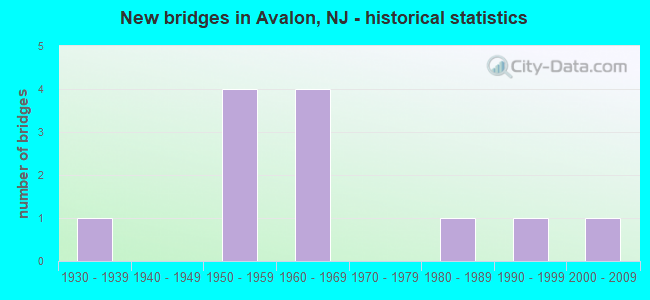
- New bridges - historical statistics
- 11930-1939
- 41950-1959
- 41960-1969
- 11980-1989
- 11990-1999
- 12000-2009

- Reconstructed bridges - Historical Statistics
- 12000-2009
- 12010-2019


- Bridge Condition - Deck
- 40.0%Good
- 60.0%Satisfactory

- Bridge Condition - Superstructure
- 10.0%Very good
- 20.0%Good
- 60.0%Satisfactory
- 10.0%Poor

- Bridge Condition - Substructure
- 20.0%Good
- 50.0%Satisfactory
- 30.0%Fair

- Bridge Condition - Channel
- 50.0%Very good
- 50.0%Good
Find on map >> Show street view
Structure Number: 500001, Location: 1.25 M W OF OCEAN DR INT. (Lat: 39.111031, Lng: -74.743611), Route carried "on" structure: County highway 601, Year Built: 1967, Status: Open, Structure Length: 51.05m (167.49ft), Average Daily Traffic: 10,200 (year 2020), Truck Traffic: 3%, Average Future Daily Traffic: 12,240 (year 2040), Design Load: HS 20, Features Intersected: INGRAMS THOROFARE
Minimum Vertical Clearance: 30+ m (98+ ft), Kilometerpoint: 4.104, Lanes on structure: 2, Owner: County Highway Agency, Approaching Roadway Width: 11.0m (36.1ft), Navigation Control: Yes ( Vertical Clearance: 10.7m (35.1ft), Horizontal Clearance: 24.4m (80.1ft)), Material/Design: Steel, Design/Construction: Girder and Floorbeam System, Number Of Spans In Main Unit: 1, Number Of Approach Spans: 22, Length of Maximum Span: 30.5m (100.1ft), Curb or Sidewalk Widths: Left: 0.8m (2.6ft), Right: 0.8m (2.6ft), Curb-To-Curb Width: 8.5m (27.9ft), Out-to-Out Width: 10.8m (35.4ft)
Condition: Deck: Satisfactory, Superstructure: Satisfactory, Substructure: Satisfactory, Channel: Good, Operating Rating: 54.4 metric tons, Method Used To Determine Operating Rating: Load Factor (LF), Inventory Rating: 28.1 metric tons, Method Used To Determine Inventory Rating: Load Factor (LF), Structural Evaluation: Equal to present minimum criteria, Deck Geometry: Meets minimum limits, Waterway Adequacy: Equal to present desirable criteria, Approach Roadway Alignment: Equal to present desirable criteria, Designated Inspection Frequency: Every 24 months, Critical Feature Inspection Frequency: Every 24 months, Underwater Inspection Frequency: Every 48 months, Inspection Date: June 2020, Critical Feature Inspection Date: June 2020, Underwater Inspection Date: August 2020, Deck Structure Type: Concrete Cast-file-Place, Wearing Surface/Protective System: Wearing Surface: Monolithic Concrete
Find on map >> Show street view
Structure Number: 500003, Location: 0.82 W OF OCEAN DR INTER. (Lat: 39.103669, Lng: -74.737969), Route carried "on" structure: County highway 601, Year Built: 1967, Status: Open, Structure Length: 11.06m (36.29ft), Average Daily Traffic: 9,484 (year 2020), Truck Traffic: 3%, Average Future Daily Traffic: 11,570 (year 2040), Design Load: HS 20, Features Intersected: GRAVENS THOROFARE
Minimum Vertical Clearance: 30.45m (99.90ft), Kilometerpoint: 4.828, Lanes on structure: 2, Owner: County Highway Agency, Approaching Roadway Width: 10.4m (34.1ft), Skew: 4 degrees, Material/Design: Prestressed concrete, Design/Construction: Box Beam or Girders - Multiple, Number Of Spans In Main Unit: 9, Length of Maximum Span: 12.2m (40.0ft), Curb or Sidewalk Widths: Left: 0.8m (2.6ft), Right: 0.8m (2.6ft), Curb-To-Curb Width: 8.5m (27.9ft), Out-to-Out Width: 10.9m (35.8ft)
Condition: Deck: Satisfactory, Superstructure: Good, Substructure: Fair, Channel: Very good, Operating Rating: 70.8 metric tons, Method Used To Determine Operating Rating: Load Factor (LF), Inventory Rating: 42.6 metric tons, Method Used To Determine Inventory Rating: Load Factor (LF), Structural Evaluation: Somewhat better than minimum adequacy, Deck Geometry: Meets minimum limits, Waterway Adequacy: Equal to present desirable criteria, Approach Roadway Alignment: Better than present minimum criteria, Designated Inspection Frequency: Every 24 months, Underwater Inspection Frequency: Every 48 months, Inspection Date: June 2020, Underwater Inspection Date: September 2018, Deck Structure Type: Concrete Cast-file-Place, Wearing Surface/Protective System: Wearing Surface: Monolithic Concrete
Find on map >> Show street view
Structure Number: 500008, Location: 100 FT W OF 30TH&OCEAN DR (Lat: 39.097250, Lng: -74.725761), Route carried "on" structure: County highway 601, Year Built: 1967, Year Reconstructed: 2011, Status: Open, Structure Length: 4.94m (16.21ft), Average Daily Traffic: 10,450 (year 2020), Truck Traffic: 3%, Average Future Daily Traffic: 12,540 (year 2040), Design Load: HS 20, Features Intersected: AVALON CANAL
Minimum Vertical Clearance: 30.45m (99.90ft), Kilometerpoint: 6.083, Lanes on structure: 3, Owner: County Highway Agency, Approaching Roadway Width: 13.4m (44.0ft), Material/Design: Prestressed concrete, Design/Construction: Box Beam or Girders - Multiple, Number Of Spans In Main Unit: 4, Length of Maximum Span: 12.2m (40.0ft), Curb or Sidewalk Widths: Left: 1.8m (5.9ft), Right: 0.0m, Curb-To-Curb Width: 13.4m (44.0ft), Out-to-Out Width: 16.2m (53.1ft)
Condition: Deck: Good, Superstructure: Satisfactory, Substructure: Satisfactory, Channel: Very good, Operating Rating: 81.6 metric tons, Method Used To Determine Operating Rating: Load Factor (LF), Inventory Rating: 49.0 metric tons, Method Used To Determine Inventory Rating: Load Factor (LF), Structural Evaluation: Equal to present minimum criteria, Deck Geometry: Somewhat better than minimum adequacy, Waterway Adequacy: Equal to present desirable criteria, Approach Roadway Alignment: Equal to present desirable criteria, Designated Inspection Frequency: Every 24 months, Underwater Inspection Frequency: Every 48 months, Inspection Date: June 2020, Underwater Inspection Date: September 2018, Deck Structure Type: Concrete Cast-file-Place, Wearing Surface/Protective System: Wearing Surface: Monolithic Concrete, Deck Protection: Epoxy Coated Reinforcing
Find on map >> Show street view
Structure Number: 500009, Location: 2 MI W OF OCEAN DR INTER (Lat: 39.116339, Lng: -74.752011), Route carried "on" structure: County highway 601, Year Built: 1967, Status: Open, Structure Length: 20.79m (68.21ft), Average Daily Traffic: 11,264 (year 2020), Truck Traffic: 3%, Average Future Daily Traffic: 13,742 (year 2040), Design Load: HS 20, Features Intersected: LEONARD'S THOROFARE
Minimum Vertical Clearance: 30+ m (98+ ft), Kilometerpoint: 2.977, Lanes on structure: 2, Owner: County Highway Agency, Approaching Roadway Width: 12.8m (42.0ft), Skew: 3 degrees, Material/Design: Prestressed concrete, Design/Construction: Box Beam or Girders - Multiple, Number Of Spans In Main Unit: 17, Length of Maximum Span: 12.2m (40.0ft), Curb or Sidewalk Widths: Left: 0.9m (3.0ft), Right: 0.9m (3.0ft), Curb-To-Curb Width: 8.5m (27.9ft), Out-to-Out Width: 11.0m (36.1ft)
Condition: Deck: Satisfactory, Superstructure: Satisfactory, Substructure: Satisfactory, Channel: Good, Operating Rating: 48.1 metric tons, Method Used To Determine Operating Rating: Load Factor (LF), Inventory Rating: 29.0 metric tons, Method Used To Determine Inventory Rating: Load Factor (LF), Structural Evaluation: Equal to present minimum criteria, Deck Geometry: Meets minimum limits, Waterway Adequacy: Equal to present minimum criteria, Approach Roadway Alignment: Equal to present desirable criteria, Designated Inspection Frequency: Every 24 months, Underwater Inspection Frequency: Every 48 months, Inspection Date: June 2020, Underwater Inspection Date: September 2018, Deck Structure Type: Concrete Cast-file-Place, Wearing Surface/Protective System: Wearing Surface: Monolithic Concrete
Find on map >> Show street view
Structure Number: 50001, Location: 0.03 MI WEST OCEAN DRIVE (Lat: 39.103061, Lng: -74.720839), Route carried "on" structure: City street , Year Built: 1990, Status: Open, Structure Length: 4.36m (14.30ft), Average Daily Traffic: 1,770 (year 2020), Truck Traffic: 3%, Average Future Daily Traffic: 2,125 (year 2040), Design Load: HS 20+Mod, Features Intersected: AVALON CANAL, Facility Carried by Structure: 21ST STREET
Minimum Vertical Clearance: 30+ m (98+ ft), Kilometerpoint: 0.000, Lanes on structure: 2, Owner: County Highway Agency, Approaching Roadway Width: 11.0m (36.1ft), Navigation Control: Yes ( Vertical Clearance: 1.8m (5.9ft), Horizontal Clearance: 10.4m (34.1ft)), Material/Design: Prestressed concrete, Design/Construction: Box Beam or Girders - Multiple, Number Of Spans In Main Unit: 3, Length of Maximum Span: 14.6m (47.9ft), Curb or Sidewalk Widths: Left: 1.7m (5.6ft), Right: 1.7m (5.6ft), Curb-To-Curb Width: 11.0m (36.1ft), Out-to-Out Width: 14.9m (48.9ft)
Condition: Deck: Good, Superstructure: Very good, Substructure: Satisfactory, Channel: Very good, Inventory Rating: 60.8 metric tons, Method Used To Determine Inventory Rating: Load Factor (LF), Structural Evaluation: Equal to present minimum criteria, Deck Geometry: Equal to present minimum criteria, Waterway Adequacy: Equal to present desirable criteria, Approach Roadway Alignment: Equal to present minimum criteria, Designated Inspection Frequency: Every 24 months, Underwater Inspection Frequency: Every 48 months, Inspection Date: June 2020, Underwater Inspection Date: August 2018, Deck Structure Type: Concrete Cast-file-Place, Wearing Surface/Protective System: Wearing Surface: Monolithic Concrete, Deck Protection: Epoxy Coated Reinforcing
Find on map >> Show street view
Structure Number: 500024, Location: .03 MI.W.OF OCEAN DRIVE (Lat: 39.100511, Lng: -74.723011), Route carried "on" structure: County highway , Year Built: 1987, Status: Open, Structure Length: 4.33m (14.21ft), Average Daily Traffic: 2,280 (year 2020), Truck Traffic: 3%, Average Future Daily Traffic: 2,735 (year 2040), Design Load: HS 20, Features Intersected: AVALON CANAL, Facility Carried by Structure: 25TH STREET
Minimum Vertical Clearance: 30+ m (98+ ft), Kilometerpoint: 0.000, Lanes on structure: 2, Owner: County Highway Agency, Approaching Roadway Width: 11.0m (36.1ft), Navigation Control: Yes ( Vertical Clearance: 1.8m (5.9ft), Horizontal Clearance: 10.1m (33.1ft)), Material/Design: Prestressed concrete, Design/Construction: Box Beam or Girders - Multiple, Number Of Spans In Main Unit: 4, Length of Maximum Span: 10.7m (35.1ft), Curb or Sidewalk Widths: Left: 1.8m (5.9ft), Right: 1.8m (5.9ft), Curb-To-Curb Width: 11.0m (36.1ft), Out-to-Out Width: 15.2m (49.9ft)
Condition: Deck: Good, Superstructure: Satisfactory, Substructure: Fair, Channel: Very good, Operating Rating: 78.9 metric tons, Method Used To Determine Operating Rating: Load Factor (LF), Inventory Rating: 53.5 metric tons, Method Used To Determine Inventory Rating: Load Factor (LF), Structural Evaluation: Somewhat better than minimum adequacy, Deck Geometry: Somewhat better than minimum adequacy, Waterway Adequacy: Better than present minimum criteria, Approach Roadway Alignment: Better than present minimum criteria, Designated Inspection Frequency: Every 24 months, Underwater Inspection Frequency: Every 48 months, Inspection Date: June 2020, Underwater Inspection Date: August 2018, Deck Structure Type: Concrete Cast-file-Place, Wearing Surface/Protective System: Wearing Surface: Monolithic Concrete, Deck Protection: Epoxy Coated Reinforcing
Find on map >> Show street view
Structure Number: 3100001, Location: 2.7 m N of 9th St (NJ 52) (Lat: 39.297150, Lng: -74.556489), Route carried "on" structure: County highway 656, Year Built: 2002, Status: Open, Structure Length: 108.36m (355.51ft), Average Daily Traffic: 2,853 (year 2020), Truck Traffic: 4%, Average Future Daily Traffic: 3,424 (year 2040), Design Load: HS 20+Mod, Features Intersected: GREAT EGG HARBOR
Minimum Vertical Clearance: 30+ m (98+ ft), Kilometerpoint: 7.918, Lanes on structure: 2, Toll: Toll bridge, Owner: Local Toll Authority, Maintenance Responsibility: County Highway Agency, Approaching Roadway Width: 11.9m (39.0ft), Navigation Control: Yes ( Vertical Clearance: 19.8m (65.0ft), Horizontal Clearance: 45.7m (149.9ft)), Material/Design: Prestressed concrete continuous, Design/Construction: Stringer/Multi-beam, Number Of Spans In Main Unit: 26, Number Of Approach Spans: 17, Length of Maximum Span: 67.7m (222.1ft), Curb-To-Curb Width: 11.6m (38.1ft), Out-to-Out Width: 12.3m (40.4ft)
Condition: Deck: Satisfactory, Superstructure: Satisfactory, Substructure: Satisfactory, Channel: Good, Operating Rating: 59.0 metric tons, Method Used To Determine Operating Rating: Load Factor (LF), Inventory Rating: 35.4 metric tons, Method Used To Determine Inventory Rating: Load Factor (LF), Structural Evaluation: Equal to present minimum criteria, Deck Geometry: Somewhat better than minimum adequacy, Waterway Adequacy: Superior to present desirable criteria, Approach Roadway Alignment: Equal to present minimum criteria, Designated Inspection Frequency: Every 24 months, Underwater Inspection Frequency: Every 48 months, Inspection Date: October 2020, Underwater Inspection Date: October 2018, Deck Structure Type: Concrete Precast Panels, Wearing Surface/Protective System: Wearing Surface: Latex Concrete, Deck Protection: Epoxy Coated Reinforcing
Find on map >> Show street view
Structure Number: 3100003, Location: 1.81 Mi N of CR 601 (Lat: 39.117561, Lng: -74.716269), Route carried "on" structure: County highway 619, Year Built: 1939, Year Reconstructed: 2019, Status: Posted for load, Structure Length: 41.85m (137.30ft), Average Daily Traffic: 1,115 (year 2019), Average Future Daily Traffic: 1,338 (year 2039), Features Intersected: TOWNSENDS INLET
Minimum Vertical Clearance: 4.45m (14.60ft), Kilometerpoint: 14.082, Lanes on structure: 2, Toll: Toll bridge, Owner: Local Toll Authority, Maintenance Responsibility: County Highway Agency, Approaching Roadway Width: 10.4m (34.1ft), Navigation Control: Yes ( Vertical Clearance: 7.0m (23.0ft), Horizontal Clearance: 15.2m (49.9ft)), Material/Design: Steel, Design/Construction: Movable - Bascule, Number Of Spans In Main Unit: 1, Number Of Approach Spans: 23, Length of Maximum Span: 34.1m (111.9ft), Curb or Sidewalk Widths: Left: 0.6m (2.0ft), Right: 0.6m (2.0ft), Curb-To-Curb Width: 6.0m (19.7ft), Out-to-Out Width: 9.0m (29.5ft)
Condition: Deck: Satisfactory, Superstructure: Poor, Substructure: Fair, Channel: Good, Operating Rating: 29.0 metric tons, Method Used To Determine Operating Rating: Load Factor (LF), Inventory Rating: 17.2 metric tons, Method Used To Determine Inventory Rating: Load Factor (LF), Structural Evaluation: Meets minimum limits, Deck Geometry: High priority of replacement, Waterway Adequacy: Equal to present minimum criteria, Approach Roadway Alignment: Equal to present minimum criteria, Length Of Structure Improvement: 41.85m (137.30ft), Designated Inspection Frequency: Every 24 months, Critical Feature Inspection Frequency: Every 24 months, Underwater Inspection Frequency: Every 24 months, Other Special Inspection Frequency: Every 12 months, Inspection Date: October 2021, Critical Feature Inspection Date: October 2021, Underwater Inspection Date: December 2021, Other Special Inspection Date: October 2021, Bridge Improvement Cost: $48,500,000, Roadway Improvement Cost: $2,500,000, Total Project Cost: $70,500,000 ( Estimate for 2019), Deck Structure Type: Concrete Cast-file-Place, Wearing Surface/Protective System: Wearing Surface: Monolithic Concrete
Find on map >> Show street view
Structure Number: 360136N, Location: 1.75 M S OF RTS9&83 JCT (Lat: 39.126011, Lng: -74.772031), Route carried "on" structure: Other road GSP, Year Built: 1954, Status: Open, Structure Length: 1.83m (6.00ft), Average Daily Traffic: 11,908 (year 2021), Truck Traffic: 3%, Average Future Daily Traffic: 14,530 (year 2041), Design Load: H 20, Features Intersected: AVALON BLVD (CR 601)
Minimum Vertical Clearance: 30+ m (98+ ft), Kilometerpoint: 21.887, Lanes on structure: 3, Lanes under structure: 3, Base Highway Network: Yes, Toll: On toll road, Owner: State Toll Authority, Approaching Roadway Width: 12.5m (41.0ft), Material/Design: Steel, Design/Construction: Stringer/Multi-beam, Number Of Spans In Main Unit: 1, Length of Maximum Span: 16.2m (53.1ft), Curb-To-Curb Width: 12.3m (40.4ft), Out-to-Out Width: 13.5m (44.3ft)
Condition: Deck: Satisfactory, Superstructure: Satisfactory, Substructure: Good, Operating Rating: 52.2 metric tons, Method Used To Determine Operating Rating: Load and Resistance Factor Rating (LRFR) rating reported by rating factor(RF) method using HL-93 loadings, Inventory Rating: 40.2 metric tons, Method Used To Determine Inventory Rating: Load and Resistance Factor Rating (LRFR) rating reported by rating factor(RF) method using HL-93 loadings, Structural Evaluation: Equal to present minimum criteria, Deck Geometry: Meets minimum limits, Underclear: Meets minimum limits, Approach Roadway Alignment: Equal to present desirable criteria, Designated Inspection Frequency: Every 24 months, Inspection Date: May 2021, Deck Structure Type: Concrete Cast-file-Place, Wearing Surface/Protective System: Wearing Surface: Bituminous, Membrane: Preformed Fabric
Find on map >> Show street view
Structure Number: 360136S, Location: 1.75 M S OF RTS 9&83 JCT (Lat: 39.126500, Lng: -74.772869), Route carried "on" structure: Other road GSP, Year Built: 1954, Status: Open, Structure Length: 1.83m (6.00ft), Average Daily Traffic: 11,505 (year 2021), Truck Traffic: 3%, Average Future Daily Traffic: 14,038 (year 2041), Design Load: HS 20, Features Intersected: AVALON BLVD (CR 601)
Minimum Vertical Clearance: 30+ m (98+ ft), Kilometerpoint: 21.887, Lanes on structure: 2, Lanes under structure: 2, Base Highway Network: Yes, Toll: On toll road, Owner: State Toll Authority, Approaching Roadway Width: 12.2m (40.0ft), Material/Design: Steel, Design/Construction: Stringer/Multi-beam, Number Of Spans In Main Unit: 1, Length of Maximum Span: 16.2m (53.1ft), Curb-To-Curb Width: 12.3m (40.4ft), Out-to-Out Width: 13.5m (44.3ft)
Condition: Deck: Good, Superstructure: Good, Substructure: Good, Operating Rating: 52.2 metric tons, Method Used To Determine Operating Rating: Load and Resistance Factor Rating (LRFR) rating reported by rating factor(RF) method using HL-93 loadings, Inventory Rating: 40.2 metric tons, Method Used To Determine Inventory Rating: Load and Resistance Factor Rating (LRFR) rating reported by rating factor(RF) method using HL-93 loadings, Structural Evaluation: Better than present minimum criteria, Deck Geometry: Better than present minimum criteria, Underclear: Somewhat better than minimum adequacy, Approach Roadway Alignment: Equal to present desirable criteria, Designated Inspection Frequency: Every 24 months, Inspection Date: May 2021, Deck Structure Type: Concrete Cast-file-Place, Wearing Surface/Protective System: Wearing Surface: Bituminous, Membrane: Other
Find on map >> Show street view
Structure Number: 360136N, Location: 1.75 M S OF RTS9&83 JCT (Lat: 39.126011, Lng: -74.772031), Route carried "under" structure: County highway 601, Year Built: 1954, Structure Length: 0. m, Average Daily Traffic: 13,659 (year 2021), Truck Traffic: 3%, Features Intersected: AVALON BLVD (CR 601), Facility Carried by Structure: GSP NB
Minimum Vertical Clearance: 4.44m (14.57ft), Kilometerpoint: 0.853, Lanes on structure: 3, Lanes under structure: 3, Material/Design: Steel, Design/Construction: Stringer/Multi-beam, Length of Maximum Span: 16.2m (53.1ft)
Find on map >> Show street view
Structure Number: 360136S, Location: 1.75 M S OF RTS 9&83 JCT (Lat: 39.126500, Lng: -74.772869), Route carried "under" structure: County highway 601, Year Built: 1954, Structure Length: 0. m, Average Daily Traffic: 13,659 (year 2021), Truck Traffic: 3%, Features Intersected: AVALON BLVD (CR 601), Facility Carried by Structure: GSP SB
Minimum Vertical Clearance: 4.60m (15.09ft), Kilometerpoint: 0.756, Lanes on structure: 2, Lanes under structure: 2, Material/Design: Steel, Design/Construction: Stringer/Multi-beam, Length of Maximum Span: 16.2m (53.1ft)