Bridge Statistics for Bagdad, Florida (FL)
Condition, Traffic, Stress, Structural Evaluation, Project Costs
- National Bridge Inventory (NBI) Statistics
- 14Number of bridges
- 755ft / 230mTotal length
- 185,802Total average daily traffic
- 34,751Total average daily truck traffic
- National Bridge Inventory (NBI) Registered Bridges for Bagdad
- No street view available for this location
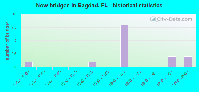
- New bridges - historical statistics
- 11900-1909
- 11940-1949
- 81960-1969
- 21990-1999
- 22000-2009

- Reconstructed bridges - Historical Statistics
- 11960-1969
- 01970-1979
- 01980-1989
- 11990-1999


- Bridge Condition - Deck
- 12.5%Good
- 75.0%Satisfactory
- 12.5%Fair

- Bridge Condition - Superstructure
- 50.0%Good
- 50.0%Satisfactory

- Bridge Condition - Substructure
- 62.5%Good
- 37.5%Satisfactory

- Bridge Condition - Channel
- 25.0%Excellent
- 25.0%Very good
- 25.0%Good
- 12.5%Fair
- 12.5%Poor

- Bridge Condition - Culverts
- 66.7%Satisfactory
- 33.3%Fair
Find on map >> Show street view
Structure Number: 580003, Location: 1.1 mi South of SR 87 (Lat: 30.607072, Lng: -87.034781), Route carried "on" structure: County highway 191, Year Built: 1946, Status: Open, Structure Length: 14.69m (48.20ft), Average Daily Traffic: 8,100 (year 2020), Truck Traffic: 8%, Average Future Daily Traffic: 14,054 (year 2042), Design Load: HS 20, Features Intersected: Pond Creek
Minimum Vertical Clearance: 30+ m (98+ ft), Kilometerpoint: 20.136, Lanes on structure: 2, Owner: County Highway Agency, Approaching Roadway Width: 7.3m (24.0ft), Material/Design: Steel, Design/Construction: Stringer/Multi-beam, Number Of Spans In Main Unit: 1, Number Of Approach Spans: 12, Length of Maximum Span: 15.2m (49.9ft), Curb or Sidewalk Widths: Left: 1.1m (3.6ft), Right: 1.1m (3.6ft), Curb-To-Curb Width: 7.3m (24.0ft), Out-to-Out Width: 10.4m (34.1ft)
Condition: Deck: Satisfactory, Superstructure: Satisfactory, Substructure: Satisfactory, Channel: Good, Operating Rating: 50.3 metric tons, Method Used To Determine Operating Rating: Load Factor (LF), Inventory Rating: 27.5 metric tons, Method Used To Determine Inventory Rating: Load Factor (LF), Structural Evaluation: Equal to present minimum criteria, Deck Geometry: High priority of replacement, Waterway Adequacy: Equal to present desirable criteria, Approach Roadway Alignment: Equal to present desirable criteria, Designated Inspection Frequency: Every 24 months, Underwater Inspection Frequency: Every 24 months, Inspection Date: July 2021, Underwater Inspection Date: July 2021, Deck Structure Type: Concrete Cast-file-Place
Find on map >> Show street view
Structure Number: 580016, Location: 0.3 Mi South of I-10 (Lat: 30.565281, Lng: -87.032881), Route carried "on" structure: County highway 191, Year Built: 1901, Year Reconstructed: 1967, Status: Open, Structure Length: 0.94m (3.08ft), Average Daily Traffic: 2,300 (year 2020), Truck Traffic: 8%, Average Future Daily Traffic: 3,991 (year 2042), Design Load: HS 20, Features Intersected: Unnamed Branch
Minimum Vertical Clearance: 30+ m (98+ ft), Kilometerpoint: 15.397, Lanes on structure: 2, Owner: County Highway Agency, Approaching Roadway Width: 7.3m (24.0ft), Material/Design: Concrete, Design/Construction: Culvert, Number Of Spans In Main Unit: 3, Length of Maximum Span: 3.2m (10.5ft)
Condition: Channel: Poor, Culverts: Fair, Operating Rating: 56.2 metric tons, Method Used To Determine Operating Rating: Load Factor (LF), Inventory Rating: 33.6 metric tons, Method Used To Determine Inventory Rating: Load Factor (LF), Structural Evaluation: Somewhat better than minimum adequacy, Waterway Adequacy: Equal to present minimum criteria, Approach Roadway Alignment: Equal to present minimum criteria, Designated Inspection Frequency: Every 24 months, Underwater Inspection Frequency: Every 12 months, Other Special Inspection Frequency: Every 12 months, Inspection Date: July 2021, Underwater Inspection Date: July 2021, Other Special Inspection Date: July 2021
Find on map >> Show street view
Structure Number: 58006, Location: 5.2 Miles West Of SR87 (Lat: 30.569717, Lng: -87.031478), Route carried "on" structure: Interstate 10, Year Built: 1967, Status: Open, Structure Length: 6.31m (20.70ft), Average Daily Traffic: 19,750 (year 2020), Truck Traffic: 21%, Average Future Daily Traffic: 34,266 (year 2042), Design Load: HS 20+Mod, Features Intersected: CR191 Garcon Point Road
Minimum Vertical Clearance: 30+ m (98+ ft), Kilometerpoint: 15.092, Lanes on structure: 2, Lanes under structure: 2, Base Highway Network: Yes, Owner: State Highway Agency, Approaching Roadway Width: 11.6m (38.1ft), Skew: 4 degrees, Material/Design: Prestressed concrete, Design/Construction: Stringer/Multi-beam, Number Of Spans In Main Unit: 3, Length of Maximum Span: 32.6m (107.0ft), Curb-To-Curb Width: 12.2m (40.0ft), Out-to-Out Width: 13.1m (43.0ft)
Condition: Deck: Satisfactory, Superstructure: Good, Substructure: Good, Operating Rating: 68.0 metric tons, Method Used To Determine Operating Rating: Load Factor (LF), Inventory Rating: 42.6 metric tons, Method Used To Determine Inventory Rating: Load Factor (LF), Structural Evaluation: Better than present minimum criteria, Deck Geometry: Better than present minimum criteria, Underclear: Equal to present minimum criteria, Approach Roadway Alignment: Equal to present desirable criteria, Designated Inspection Frequency: Every 24 months, Inspection Date: June 2020, Deck Structure Type: Concrete Cast-file-Place
Find on map >> Show street view
Structure Number: 580074, Location: 0.4mi West of CR191 (Lat: 30.565853, Lng: -87.036678), Route carried "on" structure: Interstate 10, Year Built: 1967, Status: Open, Structure Length: 1.37m (4.49ft), Average Daily Traffic: 43,500 (year 2020), Truck Traffic: 19%, Average Future Daily Traffic: 75,472 (year 2042), Design Load: HS 20, Features Intersected: Sandy Point
Minimum Vertical Clearance: 30+ m (98+ ft), Kilometerpoint: 14.486, Lanes on structure: 4, Base Highway Network: Yes, Owner: State Highway Agency, Approaching Roadway Width: 23.2m (76.1ft), Skew: 14 degrees, Material/Design: Concrete, Design/Construction: Culvert, Number Of Spans In Main Unit: 3, Length of Maximum Span: 4.4m (14.4ft)
Condition: Channel: Good, Culverts: Satisfactory, Operating Rating: 86.2 metric tons, Method Used To Determine Operating Rating: Load Factor (LF), Inventory Rating: 51.7 metric tons, Method Used To Determine Inventory Rating: Load Factor (LF), Structural Evaluation: Equal to present minimum criteria, Waterway Adequacy: Better than present minimum criteria, Approach Roadway Alignment: Equal to present desirable criteria, Designated Inspection Frequency: Every 24 months, Underwater Inspection Frequency: Every 24 months, Inspection Date: June 2020, Underwater Inspection Date: June 2020
Find on map >> Show street view
Structure Number: 580075, Location: 5.2 Miles West Of SR87 (Lat: 30.570042, Lng: -87.031469), Route carried "on" structure: Interstate 10, Year Built: 1967, Status: Open, Structure Length: 6.31m (20.70ft), Average Daily Traffic: 19,750 (year 2020), Truck Traffic: 21%, Average Future Daily Traffic: 34,266 (year 2042), Design Load: HS 20+Mod, Features Intersected: CR191 Garcon Point Road
Minimum Vertical Clearance: 30+ m (98+ ft), Kilometerpoint: 15.092, Lanes on structure: 2, Lanes under structure: 4, Base Highway Network: Yes, Owner: State Highway Agency, Approaching Roadway Width: 11.6m (38.1ft), Skew: 4 degrees, Material/Design: Prestressed concrete, Design/Construction: Stringer/Multi-beam, Number Of Spans In Main Unit: 3, Length of Maximum Span: 32.6m (107.0ft), Curb-To-Curb Width: 12.2m (40.0ft), Out-to-Out Width: 13.1m (43.0ft)
Condition: Deck: Satisfactory, Superstructure: Satisfactory, Substructure: Good, Operating Rating: 68.0 metric tons, Method Used To Determine Operating Rating: Load Factor (LF), Inventory Rating: 42.6 metric tons, Method Used To Determine Inventory Rating: Load Factor (LF), Structural Evaluation: Equal to present minimum criteria, Deck Geometry: Better than present minimum criteria, Underclear: Equal to present minimum criteria, Approach Roadway Alignment: Equal to present desirable criteria, Designated Inspection Frequency: Every 24 months, Inspection Date: June 2020, Deck Structure Type: Concrete Cast-file-Place
Find on map >> Show street view
Structure Number: 580076, Location: 4.4mi West of SR87 (Lat: 30.579078, Lng: -87.019686), Route carried "on" structure: County highway 191C, Year Built: 1967, Year Reconstructed: 1995, Status: Open, Structure Length: 6.37m (20.90ft), Average Daily Traffic: 463 (year 2010), Truck Traffic: 3%, Average Future Daily Traffic: 803 (year 2032), Design Load: HS 20, Features Intersected: I10 SR8
Minimum Vertical Clearance: 30+ m (98+ ft), Kilometerpoint: 3.259, Lanes on structure: 2, Lanes under structure: 4, Owner: State Highway Agency, Approaching Roadway Width: 7.3m (24.0ft), Material/Design: Prestressed concrete, Design/Construction: Stringer/Multi-beam, Number Of Spans In Main Unit: 2, Length of Maximum Span: 31.9m (104.7ft), Curb or Sidewalk Widths: Left: 0.4m (1.3ft), Right: 0.4m (1.3ft), Curb-To-Curb Width: 7.3m (24.0ft), Out-to-Out Width: 8.9m (29.2ft)
Condition: Deck: Good, Superstructure: Satisfactory, Substructure: Good, Inventory Rating: 78.0 metric tons, Method Used To Determine Inventory Rating: Load Factor (LF), Structural Evaluation: Equal to present minimum criteria, Deck Geometry: Meets minimum limits, Underclear: Somewhat better than minimum adequacy, Approach Roadway Alignment: Equal to present desirable criteria, Designated Inspection Frequency: Every 24 months, Inspection Date: July 2020, Deck Structure Type: Concrete Cast-file-Place
Find on map >> Show street view
Structure Number: 580167, Location: 4.0 Miles West of SR87 (Lat: 30.584650, Lng: -87.012944), Route carried "on" structure: Interstate 10, Year Built: 1997, Status: Open, Structure Length: 94.76m (310.89ft), Average Daily Traffic: 19,750 (year 2020), Truck Traffic: 21%, Average Future Daily Traffic: 34,266 (year 2042), Design Load: HS 20+Mod, Features Intersected: Blackwater River
Minimum Vertical Clearance: 30+ m (98+ ft), Kilometerpoint: 17.064, Lanes on structure: 2, Base Highway Network: Yes, Owner: State Highway Agency, Approaching Roadway Width: 11.6m (38.1ft), Navigation Control: Yes ( Vertical Clearance: 13.7m (44.9ft), Horizontal Clearance: 38.1m (125.0ft)), Material/Design: Steel continuous, Design/Construction: Stringer/Multi-beam, Number Of Spans In Main Unit: 16, Number Of Approach Spans: 6, Length of Maximum Span: 67.1m (220.1ft), Curb-To-Curb Width: 12.2m (40.0ft), Out-to-Out Width: 13.1m (43.0ft)
Condition: Deck: Satisfactory, Superstructure: Good, Substructure: Satisfactory, Channel: Very good, Operating Rating: 55.9 metric tons, Method Used To Determine Operating Rating: Load Factor (LF), Inventory Rating: 33.6 metric tons, Method Used To Determine Inventory Rating: Load Factor (LF), Structural Evaluation: Equal to present minimum criteria, Deck Geometry: Better than present minimum criteria, Waterway Adequacy: Superior to present desirable criteria, Approach Roadway Alignment: Equal to present desirable criteria, Designated Inspection Frequency: Every 24 months, Underwater Inspection Frequency: Every 24 months, Inspection Date: November 2020, Underwater Inspection Date: November 2020, Deck Structure Type: Concrete Cast-file-Place
Find on map >> Show street view
Structure Number: 580168, Location: 4.0 Miles West of SR87 (Lat: 30.584256, Lng: -87.012708), Route carried "on" structure: Interstate 10, Year Built: 1997, Status: Open, Structure Length: 94.74m (310.83ft), Average Daily Traffic: 19,750 (year 2020), Truck Traffic: 21%, Average Future Daily Traffic: 34,266 (year 2042), Design Load: HS 20+Mod, Features Intersected: Blackwater River
Minimum Vertical Clearance: 30+ m (98+ ft), Kilometerpoint: 17.064, Lanes on structure: 2, Base Highway Network: Yes, Owner: State Highway Agency, Approaching Roadway Width: 11.6m (38.1ft), Navigation Control: Yes ( Vertical Clearance: 13.0m (42.7ft), Horizontal Clearance: 38.1m (125.0ft)), Material/Design: Steel continuous, Design/Construction: Stringer/Multi-beam, Number Of Spans In Main Unit: 16, Number Of Approach Spans: 6, Length of Maximum Span: 67.1m (220.1ft), Curb-To-Curb Width: 12.2m (40.0ft), Out-to-Out Width: 13.1m (43.0ft)
Condition: Deck: Satisfactory, Superstructure: Satisfactory, Substructure: Satisfactory, Channel: Very good, Operating Rating: 58.1 metric tons, Method Used To Determine Operating Rating: Load Factor (LF), Inventory Rating: 34.8 metric tons, Method Used To Determine Inventory Rating: Load Factor (LF), Structural Evaluation: Equal to present minimum criteria, Deck Geometry: Better than present minimum criteria, Waterway Adequacy: Equal to present desirable criteria, Approach Roadway Alignment: Equal to present desirable criteria, Designated Inspection Frequency: Every 24 months, Underwater Inspection Frequency: Every 24 months, Inspection Date: November 2020, Underwater Inspection Date: November 2020, Deck Structure Type: Concrete Cast-file-Place
Find on map >> Show street view
Structure Number: 58418, Location: 0.12 Mi S of CR 191C (Lat: 30.548931, Lng: -87.026011), Route carried "on" structure: County highway , Year Built: 2000, Status: Open, Structure Length: 1.24m (4.07ft), Average Daily Traffic: 75 (year 2020), Average Future Daily Traffic: 130 (year 2042), Design Load: HS 20, Features Intersected: Unnamed Branch, Facility Carried by Structure: Waterview Drive
Minimum Vertical Clearance: 30+ m (98+ ft), Kilometerpoint: 0.241, Lanes on structure: 2, Owner: County Highway Agency, Approaching Roadway Width: 6.4m (21.0ft), Material/Design: Wood or Timber, Design/Construction: Stringer/Multi-beam, Number Of Spans In Main Unit: 4, Length of Maximum Span: 3.2m (10.5ft), Curb or Sidewalk Widths: Left: 0.1m (0.3ft), Right: 0.1m (0.3ft), Curb-To-Curb Width: 7.0m (23.0ft), Out-to-Out Width: 7.3m (24.0ft)
Condition: Deck: Fair, Superstructure: Good, Substructure: Good, Channel: Excellent, Operating Rating: 37.2 metric tons, Method Used To Determine Operating Rating: Allowable Stress (AS), Inventory Rating: 28.1 metric tons, Method Used To Determine Inventory Rating: Allowable Stress (AS), Structural Evaluation: Better than present minimum criteria, Deck Geometry: Somewhat better than minimum adequacy, Waterway Adequacy: Better than present minimum criteria, Approach Roadway Alignment: Equal to present desirable criteria, Designated Inspection Frequency: Every 24 months, Underwater Inspection Frequency: Every 24 months, Inspection Date: March 2020, Underwater Inspection Date: March 2020, Deck Structure Type: Wood or Timber
Find on map >> Show street view
Structure Number: 584187, Location: 0.8 MI E of CR 191 (Lat: 30.550783, Lng: -87.031256), Route carried "on" structure: County highway , Year Built: 2002, Status: Open, Structure Length: 2.69m (8.83ft), Average Daily Traffic: 132 (year 2020), Truck Traffic: 1%, Average Future Daily Traffic: 229 (year 2042), Design Load: HS 20, Features Intersected: Jakes Bayou, Facility Carried by Structure: Robinson Pt Road
Minimum Vertical Clearance: 30+ m (98+ ft), Kilometerpoint: 1.257, Lanes on structure: 2, Owner: County Highway Agency, Approaching Roadway Width: 6.1m (20.0ft), Material/Design: Concrete, Design/Construction: Channel Beam, Number Of Spans In Main Unit: 3, Length of Maximum Span: 12.2m (40.0ft), Curb-To-Curb Width: 7.6m (24.9ft), Out-to-Out Width: 7.6m (24.9ft)
Condition: Deck: Satisfactory, Superstructure: Good, Substructure: Good, Channel: Excellent, Operating Rating: 65.3 metric tons, Method Used To Determine Operating Rating: Load Factor (LF), Inventory Rating: 39.0 metric tons, Method Used To Determine Inventory Rating: Load Factor (LF), Structural Evaluation: Better than present minimum criteria, Deck Geometry: Somewhat better than minimum adequacy, Waterway Adequacy: Equal to present desirable criteria, Approach Roadway Alignment: Equal to present minimum criteria, Designated Inspection Frequency: Every 24 months, Inspection Date: August 2020, Deck Structure Type: Concrete Precast Panels
Find on map >> Show street view
Structure Number: 584219, Location: 1.28 Mi S of I-10 (Lat: 30.561111, Lng: -87.017222), Route carried "on" structure: County highway , Year Built: 1962, Status: Open, Structure Length: 0.63m (2.07ft), Average Daily Traffic: 132 (year 2020), Truck Traffic: 1%, Average Future Daily Traffic: 229 (year 2042), Design Load: HL 93, Features Intersected: Sandy Point Bayou, Facility Carried by Structure: Robinson Point Rd
Minimum Vertical Clearance: 30+ m (98+ ft), Kilometerpoint: 1.213, Lanes on structure: 2, Owner: County Highway Agency, Approaching Roadway Width: 6.2m (20.3ft), Material/Design: Concrete, Design/Construction: Culvert, Number Of Spans In Main Unit: 2, Length of Maximum Span: 3.1m (10.2ft)
Condition: Channel: Fair, Culverts: Satisfactory, Operating Rating: 58.1 metric tons, Method Used To Determine Operating Rating: Load and Resistance Factor (LRFR), Inventory Rating: 44.5 metric tons, Method Used To Determine Inventory Rating: Load and Resistance Factor (LRFR), Structural Evaluation: Equal to present minimum criteria, Waterway Adequacy: Better than present minimum criteria, Approach Roadway Alignment: Equal to present desirable criteria, Designated Inspection Frequency: Every 24 months, Underwater Inspection Frequency: Every 24 months, Inspection Date: April 2020, Underwater Inspection Date: April 2020
Find on map >> Show street view
Structure Number: 58006, Location: 5.2 Miles West Of SR87 (Lat: 30.569717, Lng: -87.031478), Route carried "under" structure: County highway 191, Year Built: 1967, Structure Length: 0. m, Average Daily Traffic: 6,300 (year 2020), Truck Traffic: 6%, Features Intersected: CR191 Garcon Point Road, Facility Carried by Structure: I10 SR8
Minimum Vertical Clearance: 4.66m (15.29ft), Kilometerpoint: 15.923, Lanes on structure: 2, Lanes under structure: 2, Material/Design: Prestressed concrete, Design/Construction: Stringer/Multi-beam, Length of Maximum Span: 32.6m (107.0ft)
Find on map >> Show street view
Structure Number: 580075, Location: 5.2 Miles West Of SR87 (Lat: 30.570042, Lng: -87.031469), Route carried "under" structure: County highway 191, Year Built: 1967, Structure Length: 0. m, Average Daily Traffic: 6,300 (year 2020), Truck Traffic: 6%, Features Intersected: CR191 Garcon Point Road, Facility Carried by Structure: I10 SR8
Minimum Vertical Clearance: 4.66m (15.29ft), Kilometerpoint: 15.961, Lanes on structure: 2, Lanes under structure: 4, Material/Design: Prestressed concrete, Design/Construction: Stringer/Multi-beam, Length of Maximum Span: 32.6m (107.0ft)
Find on map >> Show street view
Structure Number: 580076, Location: 4.4mi West of SR87 (Lat: 30.579078, Lng: -87.019686), Route carried "under" structure: Interstate 10, Year Built: 1967, Structure Length: 0. m, Average Daily Traffic: 39,500 (year 2020), Truck Traffic: 21%, Features Intersected: I10 SR8, Facility Carried by Structure: CR191C
Minimum Vertical Clearance: 5.00m (16.40ft), Kilometerpoint: 16.647, Lanes on structure: 2, Lanes under structure: 4, Material/Design: Prestressed concrete, Design/Construction: Stringer/Multi-beam, Length of Maximum Span: 31.9m (104.7ft)