Bridge Statistics for Bailey, North Carolina (NC)
Condition, Traffic, Stress, Structural Evaluation, Project Costs
- National Bridge Inventory (NBI) Statistics
- 14Number of bridges
- 125ft / 38.0mTotal length
- 137,140Total average daily traffic
- 20,705Total average daily truck traffic
- National Bridge Inventory (NBI) Registered Bridges for Bailey
- No street view available for this location
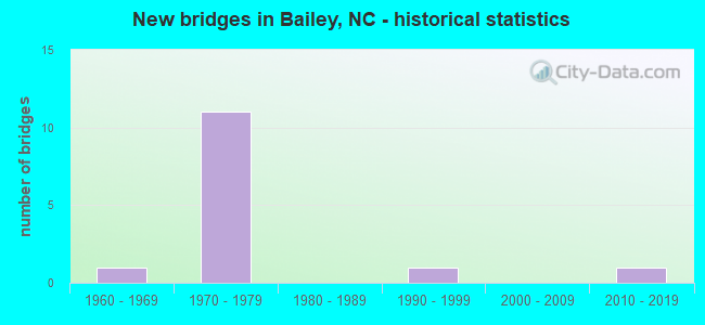
- New bridges - historical statistics
- 11960-1969
- 111970-1979
- 11990-1999
- 12010-2019


- Bridge Condition - Deck
- 20.0%Excellent
- 20.0%Good
- 60.0%Satisfactory

- Bridge Condition - Superstructure
- 20.0%Excellent
- 40.0%Good
- 40.0%Satisfactory

- Bridge Condition - Substructure
- 20.0%Excellent
- 80.0%Satisfactory

- Bridge Condition - Channel
- 50.0%Good
- 50.0%Satisfactory
Find on map >> Show street view
Structure Number: 1270053, Location: 0.2M. S. JCT. SR1175 (Lat: 35.787481, Lng: -78.116875), Route carried "on" structure: State highway 581, Year Built: 1976, Status: Open, Structure Length: 7.80m (25.59ft), Average Daily Traffic: 5,100 (year 2018), Truck Traffic: 7%, Average Future Daily Traffic: 10,200 (year 2040), Design Load: HS 20+Mod, Features Intersected: US264
Minimum Vertical Clearance: 30+ m (98+ ft), Kilometerpoint: 0.000, Lanes on structure: 5, Lanes under structure: 4, Owner: State Highway Agency, Approaching Roadway Width: 22.2m (72.8ft), Skew: 1 degrees, Material/Design: Steel, Design/Construction: Stringer/Multi-beam, Number Of Spans In Main Unit: 2, Length of Maximum Span: 39.3m (128.9ft), Curb-To-Curb Width: 25.6m (84.0ft), Out-to-Out Width: 26.2m (86.0ft)
Condition: Deck: Satisfactory, Superstructure: Satisfactory, Substructure: Satisfactory, Operating Rating: 89.8 metric tons, Method Used To Determine Operating Rating: Load Factor (LF), Inventory Rating: 65.3 metric tons, Method Used To Determine Inventory Rating: Load Factor (LF), Structural Evaluation: Equal to present minimum criteria, Deck Geometry: Superior to present desirable criteria, Underclear: Equal to present minimum criteria, Approach Roadway Alignment: Equal to present desirable criteria, Designated Inspection Frequency: Every 24 months, Inspection Date: May 2020, Deck Structure Type: Concrete Cast-file-Place, Wearing Surface/Protective System: Wearing Surface: Monolithic Concrete
Find on map >> Show street view
Structure Number: 1270055, Location: 0.2 MI S. JCT US264ALT. (Lat: 35.778725, Lng: -78.136439), Route carried "on" structure: State highway 1100, Year Built: 1999, Status: Open, Structure Length: 1.46m (4.79ft), Average Daily Traffic: 680 (year 2017), Truck Traffic: 6%, Average Future Daily Traffic: 1,360 (year 2040), Design Load: HS 20+Mod, Features Intersected: CAMP BRANCH
Minimum Vertical Clearance: 30+ m (98+ ft), Kilometerpoint: 0.000, Lanes on structure: 2, Owner: State Highway Agency, Approaching Roadway Width: 6.0m (19.7ft), Skew: 2 degrees, Material/Design: Steel, Design/Construction: Culvert, Number Of Spans In Main Unit: 3, Length of Maximum Span: 3.6m (11.8ft)
Condition: Channel: Satisfactory, Culverts: Satisfactory, Operating Rating: 89.8 metric tons, Method Used To Determine Operating Rating: Load and Resistance Factor (LRFR), Inventory Rating: 83.4 metric tons, Method Used To Determine Inventory Rating: Load and Resistance Factor (LRFR), Structural Evaluation: Equal to present minimum criteria, Waterway Adequacy: Better than present minimum criteria, Approach Roadway Alignment: Equal to present desirable criteria, Designated Inspection Frequency: Every 24 months, Inspection Date: May 2020
Find on map >> Show street view
Structure Number: 1270103, Location: 0.4 MI W. OF SR1100 (Lat: 35.775536, Lng: -78.143967), Route carried "on" structure: State highway 1105, Year Built: 2019, Status: Open, Structure Length: 3.50m (11.48ft), Average Daily Traffic: 440 (year 2017), Truck Traffic: 6%, Average Future Daily Traffic: 880 (year 2040), Design Load: HL 93, Features Intersected: HAW BRANCH
Minimum Vertical Clearance: 30+ m (98+ ft), Kilometerpoint: 0.000, Lanes on structure: 2, Owner: State Highway Agency, Approaching Roadway Width: 9.4m (30.8ft), Material/Design: Prestressed concrete, Design/Construction: Slab, Number Of Spans In Main Unit: 2, Length of Maximum Span: 16.7m (54.8ft), Curb-To-Curb Width: 9.1m (29.9ft), Out-to-Out Width: 10.0m (32.8ft)
Condition: Deck: Excellent, Superstructure: Excellent, Substructure: Excellent, Channel: Good, Operating Rating: 61.6 metric tons, Method Used To Determine Operating Rating: Load and Resistance Factor (LRFR), Inventory Rating: 47.1 metric tons, Method Used To Determine Inventory Rating: Load and Resistance Factor (LRFR), Structural Evaluation: Superior to present desirable criteria, Deck Geometry: Equal to present minimum criteria, Waterway Adequacy: Better than present minimum criteria, Approach Roadway Alignment: Equal to present desirable criteria, Designated Inspection Frequency: Every 24 months, Inspection Date: May 2020, Deck Structure Type: Concrete Precast Panels, Wearing Surface/Protective System: Wearing Surface: Bituminous, Deck Protection: Epoxy Coated Reinforcing
Find on map >> Show street view
Structure Number: 1270206, Location: 0.3 MI.S. OF SR1962 (Lat: 35.785325, Lng: -78.098467), Route carried "on" structure: State highway 1961, Year Built: 1977, Status: Open, Structure Length: 7.58m (24.87ft), Average Daily Traffic: 470 (year 2015), Truck Traffic: 6%, Average Future Daily Traffic: 940 (year 2025), Design Load: HS 15, Features Intersected: US264
Minimum Vertical Clearance: 30+ m (98+ ft), Kilometerpoint: 0.000, Lanes on structure: 2, Lanes under structure: 4, Owner: State Highway Agency, Approaching Roadway Width: 7.9m (25.9ft), Material/Design: Steel, Design/Construction: Stringer/Multi-beam, Number Of Spans In Main Unit: 2, Length of Maximum Span: 37.4m (122.7ft), Curb-To-Curb Width: 10.9m (35.8ft), Out-to-Out Width: 11.8m (38.7ft)
Condition: Deck: Good, Superstructure: Good, Substructure: Satisfactory, Operating Rating: 89.8 metric tons, Method Used To Determine Operating Rating: Load Factor (LF), Inventory Rating: 56.2 metric tons, Method Used To Determine Inventory Rating: Load Factor (LF), Structural Evaluation: Equal to present minimum criteria, Deck Geometry: Equal to present minimum criteria, Underclear: Equal to present minimum criteria, Approach Roadway Alignment: Equal to present desirable criteria, Designated Inspection Frequency: Every 24 months, Inspection Date: June 2020, Deck Structure Type: Concrete Cast-file-Place, Wearing Surface/Protective System: Wearing Surface: Monolithic Concrete
Find on map >> Show street view
Structure Number: 1270208, Location: 0.2 MI. N. SR1968 (Lat: 35.782131, Lng: -78.087350), Route carried "on" structure: State highway 1945, Year Built: 1977, Status: Open, Structure Length: 9.84m (32.28ft), Average Daily Traffic: 700 (year 2017), Truck Traffic: 6%, Average Future Daily Traffic: 1,400 (year 2040), Design Load: HS 15, Features Intersected: US264
Minimum Vertical Clearance: 30+ m (98+ ft), Kilometerpoint: 9.753, Lanes on structure: 2, Lanes under structure: 4, Owner: State Highway Agency, Approaching Roadway Width: 9.7m (31.8ft), Skew: 3 degrees, Material/Design: Steel, Design/Construction: Stringer/Multi-beam, Number Of Spans In Main Unit: 4, Length of Maximum Span: 36.8m (120.7ft), Curb-To-Curb Width: 10.9m (35.8ft), Out-to-Out Width: 11.8m (38.7ft)
Condition: Deck: Satisfactory, Superstructure: Good, Substructure: Satisfactory, Operating Rating: 48.9 metric tons, Method Used To Determine Operating Rating: Load Factor (LF), Inventory Rating: 29.0 metric tons, Method Used To Determine Inventory Rating: Load Factor (LF), Structural Evaluation: Equal to present minimum criteria, Deck Geometry: Equal to present minimum criteria, Underclear: Equal to present minimum criteria, Approach Roadway Alignment: Equal to present desirable criteria, Designated Inspection Frequency: Every 24 months, Inspection Date: May 2020, Deck Structure Type: Concrete Cast-file-Place, Wearing Surface/Protective System: Wearing Surface: Monolithic Concrete, Deck Protection: Epoxy Coated Reinforcing
Find on map >> Show street view
Structure Number: 1810001, Location: 0.6 OF A MI. S. OF SR1126 (Lat: 36.321067, Lng: -78.504867), Route carried "on" structure: Interstate 85, Year Built: 1969, Year Reconstructed: 2008, Status: Open, Structure Length: 7.77m (25.49ft), Average Daily Traffic: 22,750 (year 2019), Truck Traffic: 23%, Average Future Daily Traffic: 45,500 (year 2040), Design Load: HS 20+Mod, Features Intersected: US158 BYP
Minimum Vertical Clearance: 30+ m (98+ ft), Kilometerpoint: 63.612, Lanes on structure: 2, Lanes under structure: 2, Base Highway Network: Yes (Inventory Route: 1, Subroute: 85), Owner: State Highway Agency, Approaching Roadway Width: 11.2m (36.7ft), Skew: 13 degrees, Material/Design: Steel continuous, Design/Construction: Stringer/Multi-beam, Number Of Spans In Main Unit: 2, Length of Maximum Span: 38.4m (126.0ft), Curb-To-Curb Width: 11.1m (36.4ft), Out-to-Out Width: 12.8m (42.0ft)
Condition: Deck: Satisfactory, Superstructure: Satisfactory, Substructure: Satisfactory, Operating Rating: 82.5 metric tons, Method Used To Determine Operating Rating: Load Factor (LF), Inventory Rating: 48.9 metric tons, Method Used To Determine Inventory Rating: Load Factor (LF), Structural Evaluation: Equal to present minimum criteria, Deck Geometry: Somewhat better than minimum adequacy, Underclear: Better than present minimum criteria, Approach Roadway Alignment: Equal to present desirable criteria, Designated Inspection Frequency: Every 24 months, Inspection Date: December 2021, Deck Structure Type: Concrete Cast-file-Place, Wearing Surface/Protective System: Wearing Surface: Monolithic Concrete
Find on map >> Show street view
Structure Number: 1270053, Location: 0.2M. S. JCT. SR1175 (Lat: 35.787481, Lng: -78.116875), Route carried "under" structure: US 264, Year Built: 1976, Structure Length: 0. m, Average Daily Traffic: 13,000 (year 2017), Truck Traffic: 14%, Features Intersected: NC581
Minimum Vertical Clearance: 5.53m (18.14ft), Kilometerpoint: 9.326, Lanes on structure: 5, Lanes under structure: 2, Material/Design: Steel, Design/Construction: Stringer/Multi-beam, Length of Maximum Span: 39.3m (128.9ft)
Find on map >> Show street view
Structure Number: 1270053, Location: 0.2M. S. JCT. SR1175 (Lat: 35.787481, Lng: -78.116875), Route carried "under" structure: US 264, Year Built: 1976, Structure Length: 0. m, Average Daily Traffic: 13,000 (year 2017), Truck Traffic: 14%, Features Intersected: NC581
Minimum Vertical Clearance: 5.10m (16.73ft), Kilometerpoint: 9.235, Lanes on structure: 5, Lanes under structure: 2, Material/Design: Steel, Design/Construction: Stringer/Multi-beam, Length of Maximum Span: 39.3m (128.9ft)
Find on map >> Show street view
Structure Number: 127018, Location: 0.4 MI.S. OF SR1175 (Lat: 35.789375, Lng: -78.138131), Route carried "under" structure: US 264, Year Built: 1976, Structure Length: 0. m, Average Daily Traffic: 13,000 (year 2017), Truck Traffic: 14%, Features Intersected: SR1106
Minimum Vertical Clearance: 5.02m (16.47ft), Kilometerpoint: 8.686, Lanes on structure: 2, Lanes under structure: 2, Material/Design: Steel, Design/Construction: Stringer/Multi-beam, Length of Maximum Span: 38.4m (126.0ft)
Find on map >> Show street view
Structure Number: 127018, Location: 0.4 MI.S. OF SR1175 (Lat: 35.789375, Lng: -78.138131), Route carried "under" structure: US 264, Year Built: 1976, Structure Length: 0. m, Average Daily Traffic: 13,000 (year 2018), Truck Traffic: 14%, Features Intersected: SR1106
Minimum Vertical Clearance: 5.02m (16.47ft), Kilometerpoint: 8.686, Lanes on structure: 2, Lanes under structure: 2, Material/Design: Steel, Design/Construction: Stringer/Multi-beam, Length of Maximum Span: 38.4m (126.0ft)
Find on map >> Show street view
Structure Number: 1270206, Location: 0.3 MI.S. OF SR1962 (Lat: 35.785325, Lng: -78.098467), Route carried "under" structure: US 264, Year Built: 1977, Structure Length: 0. m, Average Daily Traffic: 12,500 (year 2015), Truck Traffic: 14%, Features Intersected: SR1961
Minimum Vertical Clearance: 5.08m (16.67ft), Kilometerpoint: 0.000, Lanes on structure: 2, Lanes under structure: 2, Material/Design: Steel, Design/Construction: Stringer/Multi-beam, Length of Maximum Span: 37.4m (122.7ft)
Find on map >> Show street view
Structure Number: 1270206, Location: 0.3 MI.S. OF SR1962 (Lat: 35.785325, Lng: -78.098467), Route carried "under" structure: US 264, Year Built: 1977, Structure Length: 0. m, Average Daily Traffic: 12,500 (year 2015), Truck Traffic: 14%, Features Intersected: SR1961
Minimum Vertical Clearance: 4.87m (15.98ft), Kilometerpoint: 9.540, Lanes on structure: 2, Lanes under structure: 2, Material/Design: Steel, Design/Construction: Stringer/Multi-beam, Length of Maximum Span: 37.4m (122.7ft)
Find on map >> Show street view
Structure Number: 1270208, Location: 0.2 MI. N. SR1968 (Lat: 35.782131, Lng: -78.087350), Route carried "under" structure: US 264, Year Built: 1977, Structure Length: 0. m, Average Daily Traffic: 15,000 (year 2018), Truck Traffic: 14%, Features Intersected: SR1945
Minimum Vertical Clearance: 5.28m (17.32ft), Kilometerpoint: 9.814, Lanes on structure: 2, Lanes under structure: 2, Material/Design: Steel, Design/Construction: Stringer/Multi-beam, Length of Maximum Span: 36.8m (120.7ft)
Find on map >> Show street view
Structure Number: 1270208, Location: 0.2 MI. N. SR1968 (Lat: 35.782131, Lng: -78.087350), Route carried "under" structure: US 264, Year Built: 1977, Structure Length: 0. m, Average Daily Traffic: 15,000 (year 2018), Truck Traffic: 14%, Features Intersected: SR1945
Minimum Vertical Clearance: 5.18m (16.99ft), Kilometerpoint: 9.814, Lanes on structure: 2, Lanes under structure: 2, Material/Design: Steel, Design/Construction: Stringer/Multi-beam, Length of Maximum Span: 36.8m (120.7ft)