Bridge Statistics for Balcones Heights, Texas (TX)
Condition, Traffic, Stress, Structural Evaluation, Project Costs
- National Bridge Inventory (NBI) Statistics
- 11Number of bridges
- 732ft / 223mTotal length
- $3,915,000Total costs
- 750,219Total average daily traffic
- 33,560Total average daily truck traffic
- National Bridge Inventory (NBI) Registered Bridges for Balcones Heights
- No street view available for this location
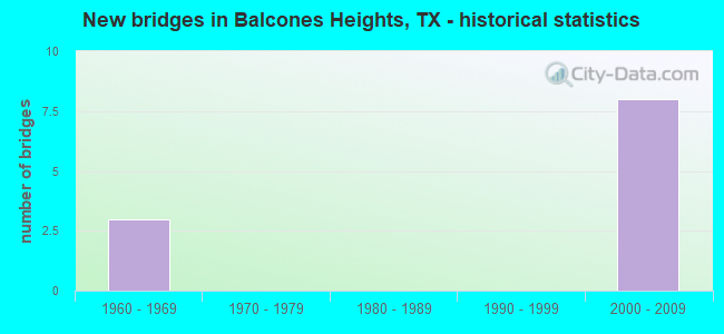
- New bridges - historical statistics
- 31960-1969
- 82000-2009


- Bridge Condition - Superstructure
- 50.0%Very good
- 50.0%Good

- Bridge Condition - Substructure
- 75.0%Good
- 25.0%Satisfactory

- Bridge Condition - Channel
- 66.7%Good
- 33.3%Satisfactory

- Bridge Condition - Culverts
- 66.7%Satisfactory
- 33.3%Fair
Find on map >> Show street view
Structure Number: 150150007212075, Location: 1.3 MI S OF CALLAGHAN RD (Lat: 29.493678, Lng: -98.547372), Route carried "on" structure: ServiceInterstate 10, Year Built: 1961, Status: Open, Structure Length: 1.49m (4.89ft), Average Daily Traffic: 131,070 (year 2015), Truck Traffic: 6%, Average Future Daily Traffic: 183,500 (year 2035), Design Load: HS 20, Features Intersected: DRAIN
Minimum Vertical Clearance: 30+ m (98+ ft), Kilometerpoint: 31.126, Lanes on structure: 10, Owner: State Highway Agency, Approaching Roadway Width: 34.1m (111.9ft), Skew: 34 degrees, Material/Design: Concrete, Design/Construction: Culvert, Number Of Spans In Main Unit: 4, Length of Maximum Span: 2.4m (7.9ft), Curb or Sidewalk Widths: Left: 1.6m (5.2ft), Right: 3.5m (11.5ft)
Condition: Channel: Good, Culverts: Satisfactory, Operating Rating: 39.9 metric tons, Method Used To Determine Operating Rating: Load Factor (LF), Inventory Rating: 23.6 metric tons, Method Used To Determine Inventory Rating: Load Factor (LF), Structural Evaluation: Somewhat better than minimum adequacy, Waterway Adequacy: Equal to present minimum criteria, Approach Roadway Alignment: Equal to present desirable criteria, Designated Inspection Frequency: Every 24 months, Inspection Date: July 2020
Find on map >> Show street view
Structure Number: 150150007212078, Location: 0.8 MI N 0F VANCE JACKSON (Lat: 29.488642, Lng: -98.545406), Route carried "on" structure: Interstate 10, Year Built: 1961, Year Reconstructed: 2004, Status: Open, Structure Length: 2.71m (8.89ft), Average Daily Traffic: 159,549 (year 2020), Truck Traffic: 5%, Average Future Daily Traffic: 281,210 (year 2033), Features Intersected: DRAIN
Minimum Vertical Clearance: 30+ m (98+ ft), Kilometerpoint: 31.591, Lanes on structure: 17, Owner: State Highway Agency, Approaching Roadway Width: 77.4m (253.9ft), Skew: 36 degrees, Material/Design: Concrete, Design/Construction: Culvert, Number Of Spans In Main Unit: 4, Length of Maximum Span: 2.4m (7.9ft)
Condition: Channel: Good, Culverts: Fair, Operating Rating: 39.9 metric tons, Method Used To Determine Operating Rating: Load Factor (LF), Inventory Rating: 23.6 metric tons, Method Used To Determine Inventory Rating: Load Factor (LF), Structural Evaluation: Somewhat better than minimum adequacy, Waterway Adequacy: Equal to present minimum criteria, Approach Roadway Alignment: Equal to present desirable criteria, Designated Inspection Frequency: Every 24 months, Inspection Date: July 2020
Find on map >> Show street view
Structure Number: 150150007212281, Location: IH10 & IH410 INTERCHANGE (Lat: 29.493933, Lng: -98.547083), Route carried "on" structure: Ramp Interstate 10, Year Built: 2007, Status: Open, Structure Length: 123.72m (405.91ft), Average Daily Traffic: 12,000 (year 2012), Truck Traffic: 6%, Average Future Daily Traffic: 17,600 (year 2032), Design Load: HS 20, Features Intersected: IH 410 EB EXIT RAMP
Minimum Vertical Clearance: 30+ m (98+ ft), Kilometerpoint: 30.558, Lanes on structure: 2, Lanes under structure: 3, Owner: State Highway Agency, Approaching Roadway Width: 11.0m (36.1ft), Skew: 9 degrees, Material/Design: Prestressed concrete, Design/Construction: Stringer/Multi-beam, Number Of Spans In Main Unit: 36, Length of Maximum Span: 38.4m (126.0ft), Curb-To-Curb Width: 11.0m (36.1ft), Out-to-Out Width: 11.6m (38.1ft)
Condition: Deck: Good, Superstructure: Good, Substructure: Satisfactory, Operating Rating: 54.4 metric tons, Method Used To Determine Operating Rating: Assigned rating based on Load Factor Design (LFD) reported in metric tons, Inventory Rating: 32.7 metric tons, Method Used To Determine Inventory Rating: Assigned rating based on Load Factor Design (LFD) reported in metric tons, Structural Evaluation: Equal to present minimum criteria, Deck Geometry: Better than present minimum criteria, Underclear: Equal to present minimum criteria, Approach Roadway Alignment: Equal to present desirable criteria, Designated Inspection Frequency: Every 24 months, Inspection Date: July 2020, Deck Structure Type: Concrete Precast Panels
Find on map >> Show street view
Structure Number: 150150007212282, Location: IH10 & IH410 INTERCHANGE (Lat: 29.498481, Lng: -98.547764), Route carried "on" structure: Ramp Interstate 10, Year Built: 2007, Status: Open, Structure Length: 39.96m (131.10ft), Average Daily Traffic: 20,000 (year 2013), Truck Traffic: 6%, Average Future Daily Traffic: 90,000 (year 2033), Design Load: HS 20, Features Intersected: IH 410 & 10 ML
Minimum Vertical Clearance: 5.23m (17.16ft), Kilometerpoint: 27.014, Lanes on structure: 2, Lanes under structure: 22, Owner: State Highway Agency, Approaching Roadway Width: 11.0m (36.1ft), Skew: 9 degrees, Material/Design: Steel continuous, Design/Construction: Stringer/Multi-beam, Number Of Spans In Main Unit: 5, Number Of Approach Spans: 2, Length of Maximum Span: 73.8m (242.1ft), Curb-To-Curb Width: 11.0m (36.1ft), Out-to-Out Width: 11.6m (38.1ft)
Condition: Deck: Good, Superstructure: Good, Substructure: Good, Operating Rating: 44.4 metric tons, Method Used To Determine Operating Rating: Assigned rating based on Load Factor Design (LFD) reported in metric tons, Inventory Rating: 32.7 metric tons, Method Used To Determine Inventory Rating: Assigned rating based on Load Factor Design (LFD) reported in metric tons, Structural Evaluation: Better than present minimum criteria, Deck Geometry: Better than present minimum criteria, Underclear: High priority of corrective action, Approach Roadway Alignment: Equal to present desirable criteria, Designated Inspection Frequency: Every 24 months, Inspection Date: July 2020, Deck Structure Type: Concrete Cast-file-Place
Find on map >> Show street view
Structure Number: 150150007212371, Location: 0.5 MI S OF IH 410 (Lat: 29.494669, Lng: -98.547797), Route carried "on" structure: Interstate 10, Year Built: 2008, Status: Open, Structure Length: 26.91m (88.29ft), Average Daily Traffic: 83,085 (year 2012), Truck Traffic: 6%, Average Future Daily Traffic: 103,500 (year 2032), Design Load: HS 20, Features Intersected: N CROSSROADS BLVD
Minimum Vertical Clearance: 30+ m (98+ ft), Kilometerpoint: 31.141, Lanes on structure: 6, Lanes under structure: 7, Base Highway Network: Yes, Owner: State Highway Agency, Approaching Roadway Width: 28.7m (94.2ft), Material/Design: Prestressed concrete, Design/Construction: Stringer/Multi-beam, Number Of Spans In Main Unit: 9, Length of Maximum Span: 36.6m (120.1ft), Curb-To-Curb Width: 28.7m (94.2ft), Out-to-Out Width: 29.3m (96.1ft)
Condition: Deck: Good, Superstructure: Very good, Substructure: Good, Operating Rating: 54.4 metric tons, Method Used To Determine Operating Rating: Assigned rating based on Load Factor Design (LFD) reported in metric tons, Inventory Rating: 32.7 metric tons, Method Used To Determine Inventory Rating: Assigned rating based on Load Factor Design (LFD) reported in metric tons, Structural Evaluation: Better than present minimum criteria, Deck Geometry: Better than present minimum criteria, Underclear: Somewhat better than minimum adequacy, Approach Roadway Alignment: Equal to present desirable criteria, Designated Inspection Frequency: Every 24 months, Inspection Date: July 2020, Deck Structure Type: Concrete Precast Panels
Find on map >> Show street view
Structure Number: 150150007212372, Location: 0.5 MI S OF IH 410 (Lat: 29.492478, Lng: -98.546633), Route carried "on" structure: Interstate 10, Year Built: 2008, Status: Open, Structure Length: 26.91m (88.29ft), Average Daily Traffic: 83,085 (year 2012), Truck Traffic: 6%, Average Future Daily Traffic: 89,300 (year 2032), Design Load: HS 20, Features Intersected: N CROSSROADS BLVD
Minimum Vertical Clearance: 30+ m (98+ ft), Kilometerpoint: 31.141, Lanes on structure: 5, Lanes under structure: 7, Base Highway Network: Yes, Owner: State Highway Agency, Approaching Roadway Width: 25.0m (82.0ft), Skew: 9 degrees, Material/Design: Prestressed concrete, Design/Construction: Stringer/Multi-beam, Number Of Spans In Main Unit: 9, Length of Maximum Span: 35.1m (115.2ft), Curb-To-Curb Width: 25.0m (82.0ft), Out-to-Out Width: 25.6m (84.0ft)
Condition: Deck: Good, Superstructure: Very good, Substructure: Good, Operating Rating: 54.4 metric tons, Method Used To Determine Operating Rating: Assigned rating based on Load Factor Design (LFD) reported in metric tons, Inventory Rating: 32.7 metric tons, Method Used To Determine Inventory Rating: Assigned rating based on Load Factor Design (LFD) reported in metric tons, Structural Evaluation: Better than present minimum criteria, Deck Geometry: Better than present minimum criteria, Underclear: Somewhat better than minimum adequacy, Approach Roadway Alignment: Equal to present desirable criteria, Designated Inspection Frequency: Every 24 months, Inspection Date: July 2020, Deck Structure Type: Concrete Precast Panels
Find on map >> Show street view
Structure Number: 150150L00030001, Location: 0.25 MI SW OF SH 345 (Lat: 29.483544, Lng: -98.550603), Route carried "on" structure: City street , Year Built: 1962, Status: Open, Structure Length: 0.88m (2.89ft), Average Daily Traffic: 7,070 (year 2019), Average Future Daily Traffic: 8,000 (year 2039), Design Load: HS 20, Features Intersected: DRAW-NO NAME, Facility Carried by Structure: CONCORD & BALCONES
Minimum Vertical Clearance: 30+ m (98+ ft), Kilometerpoint: 0.435, Lanes on structure: 4, Owner: City or Municipal Highway Agency, Approaching Roadway Width: 18.3m (60.0ft), Skew: 9 degrees, Material/Design: Concrete, Design/Construction: Culvert, Number Of Spans In Main Unit: 3, Length of Maximum Span: 1.8m (5.9ft), Curb or Sidewalk Widths: Left: 1.3m (4.3ft), Right: 1.6m (5.2ft)
Condition: Channel: Satisfactory, Culverts: Satisfactory, Operating Rating: 39.9 metric tons, Method Used To Determine Operating Rating: Load Factor (LF), Inventory Rating: 23.6 metric tons, Method Used To Determine Inventory Rating: Load Factor (LF), Structural Evaluation: Somewhat better than minimum adequacy, Waterway Adequacy: Better than present minimum criteria, Approach Roadway Alignment: Equal to present desirable criteria, Length Of Structure Improvement: 0.88m (2.89ft), Designated Inspection Frequency: Every 24 months, Inspection Date: August 2021, Bridge Improvement Cost: $2,610,000, Roadway Improvement Cost: $261,000, Total Project Cost: $3,915,000
Find on map >> Show street view
Structure Number: 150150007212281, Location: IH10 & IH410 INTERCHANGE (Lat: 29.493933, Lng: -98.547083), Route carried "under" structure: Ramp Interstate 410, Year Built: 2007, Structure Length: 0. m, Average Daily Traffic: 60,000 (year 2012), Features Intersected: IH 410 EB EXIT RAMP
Minimum Vertical Clearance: 9.14m (29.99ft), Kilometerpoint: 27.377, Lanes on structure: 2, Lanes under structure: 3, Material/Design: Prestressed concrete, Design/Construction: Stringer/Multi-beam, Length of Maximum Span: 38.4m (126.0ft)
Find on map >> Show street view
Structure Number: 150150007212282, Location: IH10 & IH410 INTERCHANGE (Lat: 29.498481, Lng: -98.547764), Route carried "under" structure: Interstate 410, Year Built: 2007, Structure Length: 0. m, Average Daily Traffic: 169,260 (year 2013), Truck Traffic: 3%, Features Intersected: IH 410 & 10 ML
Minimum Vertical Clearance: 30+ m (98+ ft), Kilometerpoint: 27.014, Lanes on structure: 2, Lanes under structure: 22, Material/Design: Steel continuous, Design/Construction: Stringer/Multi-beam, Length of Maximum Span: 73.8m (242.1ft)
Find on map >> Show street view
Structure Number: 150150007212371, Location: 0.5 MI S OF IH 410 (Lat: 29.494669, Lng: -98.547797), Route carried "under" structure: City street , Year Built: 2008, Structure Length: 0. m, Average Daily Traffic: 12,550 (year 2012), Truck Traffic: 3%, Features Intersected: N CROSSROADS BLVD, Facility Carried by Structure: IH 10 EB
Minimum Vertical Clearance: 7.47m (24.51ft), Kilometerpoint: 0.240, Lanes on structure: 6, Lanes under structure: 7, Material/Design: Prestressed concrete, Design/Construction: Stringer/Multi-beam, Length of Maximum Span: 36.6m (120.1ft)
Find on map >> Show street view
Structure Number: 150150007212372, Location: 0.5 MI S OF IH 410 (Lat: 29.492478, Lng: -98.546633), Route carried "under" structure: City street , Year Built: 2008, Structure Length: 0. m, Average Daily Traffic: 12,550 (year 2012), Truck Traffic: 3%, Features Intersected: N CROSSROADS BLVD, Facility Carried by Structure: IH 10 WB
Minimum Vertical Clearance: 7.26m (23.82ft), Kilometerpoint: 0.240, Lanes on structure: 5, Lanes under structure: 7, Material/Design: Prestressed concrete, Design/Construction: Stringer/Multi-beam, Length of Maximum Span: 35.1m (115.2ft)