Bridge Statistics for Balmville, New York (NY)
Condition, Traffic, Stress, Structural Evaluation, Project Costs
- National Bridge Inventory (NBI) Statistics
- 10Number of bridges
- 1,617ft / 493mTotal length
- $750,056,000Total costs
- 218,390Total average daily traffic
- 18,779Total average daily truck traffic
- National Bridge Inventory (NBI) Registered Bridges for Balmville
- No street view available for this location
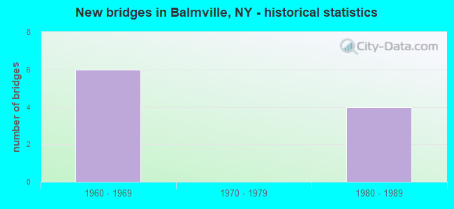
- New bridges - historical statistics
- 61960-1969
- 41980-1989

- Reconstructed bridges - Historical Statistics
- 11970-1979
- 01980-1989
- 01990-1999
- 02000-2009
- 12010-2019


- Bridge Condition - Deck
- 40.0%Very good
- 20.0%Good
- 20.0%Satisfactory
- 20.0%Poor

- Bridge Condition - Superstructure
- 20.0%Very good
- 20.0%Good
- 60.0%Satisfactory

- Bridge Condition - Substructure
- 40.0%Good
- 40.0%Satisfactory
- 20.0%Poor
Find on map >> Show street view
Structure Number: 10268, Location: .5 MI W OF EXIT 10 - I84 (Lat: 41.519444, Lng: -74.030867), Route carried "on" structure: City street , Year Built: 1963, Status: Open, Structure Length: 7.25m (23.79ft), Average Daily Traffic: 10,038 (year 2019), Truck Traffic: 4%, Average Future Daily Traffic: 14,053 (year 2039), Design Load: HS 20+Mod, Features Intersected: 84I 84I83013002 WB, RTE, Facility Carried by Structure: GIDNEY AVENUE
Minimum Vertical Clearance: 30+ m (98+ ft), Kilometerpoint: 0.837, Lanes on structure: 2, Lanes under structure: 5, Owner: State Highway Agency, Approaching Roadway Width: 9.4m (30.8ft), Material/Design: Steel, Design/Construction: Stringer/Multi-beam, Number Of Spans In Main Unit: 4, Length of Maximum Span: 23.5m (77.1ft), Curb-To-Curb Width: 8.5m (27.9ft), Out-to-Out Width: 10.1m (33.1ft)
Condition: Deck: Satisfactory, Superstructure: Satisfactory, Substructure: Poor, Operating Rating: 84.4 metric tons, Method Used To Determine Operating Rating: Load Factor (LF), Inventory Rating: 49.9 metric tons, Method Used To Determine Inventory Rating: Load Factor (LF), Structural Evaluation: Meets minimum limits, Deck Geometry: Meets minimum limits, Underclear: Meets minimum limits, Approach Roadway Alignment: Equal to present desirable criteria, Length Of Structure Improvement: 7.25m (23.79ft), Designated Inspection Frequency: Every 24 months, Inspection Date: October 2021, Bridge Improvement Cost: $2,837,000, Roadway Improvement Cost: $1,662,000, Total Project Cost: $4,499,000 ( Estimate for 2021), Deck Structure Type: Concrete Cast-file-Place, Wearing Surface/Protective System: Wearing Surface: Bituminous
Find on map >> Show street view
Structure Number: 5007299, Location: JCT 84I & RTE 9W (Lat: 41.519397, Lng: -74.020358), Route carried "on" structure: Interstate 84, Year Built: 1962, Year Reconstructed: 2019, Status: Open, Structure Length: 5.33m (17.49ft), Average Daily Traffic: 58,040 (year 2020), Truck Traffic: 16%, Average Future Daily Traffic: 98,284 (year 2040), Design Load: HS 20, Features Intersected: RTE 9W
Minimum Vertical Clearance: 30+ m (98+ ft), Kilometerpoint: 62.719, Lanes on structure: 5, Lanes under structure: 6, Base Highway Network: Yes, Owner: State Toll Authority, Approaching Roadway Width: 25.9m (85.0ft), Skew: 22 degrees, Material/Design: Steel, Design/Construction: Stringer/Multi-beam, Number Of Spans In Main Unit: 3, Length of Maximum Span: 24.6m (80.7ft), Curb-To-Curb Width: 26.5m (86.9ft), Out-to-Out Width: 27.4m (89.9ft)
Condition: Deck: Very good, Superstructure: Very good, Substructure: Good, Operating Rating: 57.2 metric tons, Method Used To Determine Operating Rating: Load Factor (LF), Inventory Rating: 34.5 metric tons, Method Used To Determine Inventory Rating: Load Factor (LF), Structural Evaluation: Better than present minimum criteria, Deck Geometry: Superior to present desirable criteria, Underclear: High priority of corrective action, Approach Roadway Alignment: Equal to present desirable criteria, Length Of Structure Improvement: 5.33m (17.49ft), Designated Inspection Frequency: Every 24 months, Inspection Date: June 2021, Bridge Improvement Cost: $5,833,000, Roadway Improvement Cost: $3,416,000, Total Project Cost: $9,249,000 ( Estimate for 2021), Deck Structure Type: Concrete Cast-file-Place, Wearing Surface/Protective System: Wearing Surface: Integral Concrete, Deck Protection: Galvanized Reinforcing
Find on map >> Show street view
Structure Number: 5060381, Location: JCT.RTE I-84 & HUDSON R. (Lat: 41.521228, Lng: -74.010158), Route carried "on" structure: Interstate 84, Year Built: 1963, Year Reconstructed: 1984, Status: Posted for load, Structure Length: 239.57m (785.99ft), Average Daily Traffic: 33,848 (year 2014), Truck Traffic: 15%, Design Load: HS 20+Mod, Features Intersected: AMTRAK, GRAND AVENUE, HU
Minimum Vertical Clearance: 5.10m (16.73ft), Kilometerpoint: 64.682, Lanes on structure: 3, Lanes under structure: 2, Base Highway Network: Yes, Toll: Toll bridge, Owner: State Toll Authority, Approaching Roadway Width: 12.2m (40.0ft), Navigation Control: Yes ( Vertical Clearance: 45.1m (148.0ft), Horizontal Clearance: 231.6m (759.8ft)), Material/Design: Steel, Design/Construction: Truss - Thru, Number Of Spans In Main Unit: 14, Number Of Approach Spans: 10, Length of Maximum Span: 304.8m (1,000.0ft), Curb-To-Curb Width: 12.0m (39.4ft), Out-to-Out Width: 13.0m (42.7ft)
Condition: Deck: Poor, Superstructure: Satisfactory, Substructure: Good, Channel: Very good, Operating Rating: 84.9 metric tons, Method Used To Determine Operating Rating: Field evaluation and documented engineering judgment, Inventory Rating: 32.7 metric tons, Method Used To Determine Inventory Rating: Field evaluation and documented engineering judgment, Structural Evaluation: Equal to present minimum criteria, Deck Geometry: High priority of corrective action, Underclear: Equal to present minimum criteria, Waterway Adequacy: Equal to present minimum criteria, Approach Roadway Alignment: Equal to present desirable criteria, Length Of Structure Improvement: 239.57m (785.99ft), Designated Inspection Frequency: Every 24 months, Critical Feature Inspection Frequency: Every 24 months, Underwater Inspection Frequency: Every 60 months, Inspection Date: June 2021, Critical Feature Inspection Date: June 2021, Underwater Inspection Date: June 2017, Bridge Improvement Cost: $198,151,000, Roadway Improvement Cost: $116,037,000, Total Project Cost: $314,188,000 ( Estimate for 2021), Deck Structure Type: Concrete Cast-file-Place, Wearing Surface/Protective System: Wearing Surface: Integral Concrete, Deck Protection: Epoxy Coated Reinforcing
Find on map >> Show street view
Structure Number: 5060382, Location: JCT RTE 84I & HUDSON R (Lat: 41.520833, Lng: -74.010200), Route carried "on" structure: Interstate 84, Year Built: 1980, Status: Posted for load, Structure Length: 237.41m (778.90ft), Average Daily Traffic: 19,962 (year 2019), Truck Traffic: 19%, Average Future Daily Traffic: 33,803 (year 2040), Design Load: HS 20+Mod, Features Intersected: GRAND AVENUE, HUDSON RIV
Minimum Vertical Clearance: 5.07m (16.63ft), Kilometerpoint: 0.000, Lanes on structure: 3, Lanes under structure: 2, Base Highway Network: Yes, Toll: Toll bridge, Owner: State Toll Authority, Approaching Roadway Width: 16.5m (54.1ft), Navigation Control: Yes ( Vertical Clearance: 45.1m (148.0ft), Horizontal Clearance: 231.6m (759.8ft)), Material/Design: Steel, Design/Construction: Truss - Thru, Number Of Spans In Main Unit: 3, Number Of Approach Spans: 19, Length of Maximum Span: 304.8m (1,000.0ft), Curb or Sidewalk Widths: Left: 0.0m, Right: 2.6m (8.5ft), Curb-To-Curb Width: 16.3m (53.5ft), Out-to-Out Width: 17.3m (56.8ft)
Condition: Deck: Very good, Superstructure: Satisfactory, Substructure: Satisfactory, Channel: Very good, Operating Rating: 47.2 metric tons, Method Used To Determine Operating Rating: Load Factor (LF), Inventory Rating: 34.5 metric tons, Method Used To Determine Inventory Rating: Load Factor (LF), Structural Evaluation: Equal to present minimum criteria, Deck Geometry: Somewhat better than minimum adequacy, Underclear: Meets minimum limits, Waterway Adequacy: Equal to present minimum criteria, Approach Roadway Alignment: Equal to present desirable criteria, Length Of Structure Improvement: 237.40m (778.87ft), Designated Inspection Frequency: Every 24 months, Critical Feature Inspection Frequency: Every 24 months, Underwater Inspection Frequency: Every 60 months, Inspection Date: June 2021, Critical Feature Inspection Date: June 2021, Underwater Inspection Date: June 2017, Bridge Improvement Cost: $263,510,000, Roadway Improvement Cost: $154,311,000, Total Project Cost: $417,821,000 ( Estimate for 2021), Deck Structure Type: Closed Grating, Wearing Surface/Protective System: Wearing Surface: Integral Concrete
Find on map >> Show street view
Structure Number: 509149, Location: .4 MI E JCT I84 & US 9W (Lat: 41.520514, Lng: -74.013256), Route carried "on" structure: Other road , Year Built: 1988, Status: Open, Structure Length: 3.60m (11.81ft), Average Daily Traffic: 5,325 (year 2018), Truck Traffic: 3%, Average Future Daily Traffic: 6,588 (year 2040), Design Load: HS 20, Features Intersected: 84I WB 84I83013011, RTE, Facility Carried by Structure: BALMVILLE RD
Minimum Vertical Clearance: 30+ m (98+ ft), Kilometerpoint: 0.322, Lanes on structure: 2, Lanes under structure: 6, Owner: State Toll Authority, Approaching Roadway Width: 9.1m (29.9ft), Material/Design: Steel, Design/Construction: Stringer/Multi-beam, Number Of Spans In Main Unit: 1, Length of Maximum Span: 35.6m (116.8ft), Curb or Sidewalk Widths: Left: 0.0m, Right: 1.5m (4.9ft), Curb-To-Curb Width: 9.1m (29.9ft), Out-to-Out Width: 11.7m (38.4ft)
Condition: Deck: Good, Superstructure: Good, Substructure: Satisfactory, Operating Rating: 69.9 metric tons, Method Used To Determine Operating Rating: Load Factor (LF), Inventory Rating: 41.7 metric tons, Method Used To Determine Inventory Rating: Load Factor (LF), Structural Evaluation: Equal to present minimum criteria, Deck Geometry: High priority of corrective action, Underclear: Meets minimum limits, Approach Roadway Alignment: Equal to present desirable criteria, Length Of Structure Improvement: 3.59m (11.78ft), Designated Inspection Frequency: Every 24 months, Inspection Date: June 2021, Bridge Improvement Cost: $2,711,000, Roadway Improvement Cost: $1,588,000, Total Project Cost: $4,299,000 ( Estimate for 2021), Deck Structure Type: Concrete Cast-file-Place, Wearing Surface/Protective System: Wearing Surface: Integral Concrete, Deck Protection: Epoxy Coated Reinforcing
Find on map >> Show street view
Structure Number: 10268, Location: .5 MI W OF EXIT 10 - I84 (Lat: 41.519444, Lng: -74.030867), Route carried "under" structure: Interstate 84, Year Built: 1963, Structure Length: 0. m, Average Daily Traffic: 19,000 (year 1971), Features Intersected: 84I 84I83013002 WB, RTE, Facility Carried by Structure: GIDNEY AVENUE
Minimum Vertical Clearance: 6.07m (19.91ft), Kilometerpoint: 61.947, Lanes on structure: 2, Lanes under structure: 2, Material/Design: Steel, Design/Construction: Stringer/Multi-beam, Length of Maximum Span: 23.5m (77.1ft)
Find on map >> Show street view
Structure Number: 5007299, Location: JCT 84I & RTE 9W (Lat: 41.519397, Lng: -74.020358), Route carried "under" structure: US 9W, Year Built: 1962, Structure Length: 0. m, Average Daily Traffic: 32,745 (year 2000), Features Intersected: RTE 9W, Facility Carried by Structure: RTE I84
Minimum Vertical Clearance: 4.90m (16.08ft), Kilometerpoint: 0.161, Lanes on structure: 5, Lanes under structure: 6, Material/Design: Steel, Design/Construction: Stringer/Multi-beam, Length of Maximum Span: 24.6m (80.7ft)
Find on map >> Show street view
Structure Number: 5060381, Location: JCT.RTE I-84 & HUDSON R. (Lat: 41.521228, Lng: -74.010158), Route carried "under" structure: City street , Year Built: 1963, Structure Length: 0. m, Average Daily Traffic: 816 (year 2016), Truck Traffic: 4%, Features Intersected: AMTRAK, GRAND AVENUE, HU, Facility Carried by Structure: RTE I84
Minimum Vertical Clearance: 5.20m (17.06ft), Kilometerpoint: 0.000, Lanes on structure: 3, Lanes under structure: 2, Material/Design: Steel, Design/Construction: Truss - Thru, Length of Maximum Span: 304.8m (1,000.0ft)
Find on map >> Show street view
Structure Number: 5060382, Location: JCT RTE 84I & HUDSON R (Lat: 41.520833, Lng: -74.010200), Route carried "under" structure: City street , Year Built: 1980, Structure Length: 0. m, Average Daily Traffic: 816 (year 2016), Truck Traffic: 4%, Features Intersected: GRAND AVENUE, HUDSON RIV, Facility Carried by Structure: RTE I84
Minimum Vertical Clearance: 4.41m (14.47ft), Kilometerpoint: 1.126, Lanes on structure: 3, Lanes under structure: 2, Material/Design: Steel, Design/Construction: Truss - Thru, Length of Maximum Span: 304.8m (1,000.0ft)
Find on map >> Show street view
Structure Number: 509149, Location: .4 MI E JCT I84 & US 9W (Lat: 41.520514, Lng: -74.013256), Route carried "under" structure: Interstate 84, Year Built: 1988, Structure Length: 0. m, Average Daily Traffic: 37,800 (year 1987), Features Intersected: 84I WB 84I83013011, RTE, Facility Carried by Structure: BALMVILLE RD
Minimum Vertical Clearance: 6.55m (21.49ft), Kilometerpoint: 1.770, Lanes on structure: 2, Lanes under structure: 3, Material/Design: Steel, Design/Construction: Stringer/Multi-beam, Length of Maximum Span: 35.6m (116.8ft)