Bridge Statistics for Bazine, Kansas (KS)
Condition, Traffic, Stress, Structural Evaluation, Project Costs
- National Bridge Inventory (NBI) Statistics
- 20Number of bridges
- 187ft / 57.3mTotal length
- $2,071,000Total costs
- 6,082Total average daily traffic
- 1,378Total average daily truck traffic
- 6,709Total future (year 2040) average daily traffic
- National Bridge Inventory (NBI) Registered Bridges for Bazine
- No street view available for this location
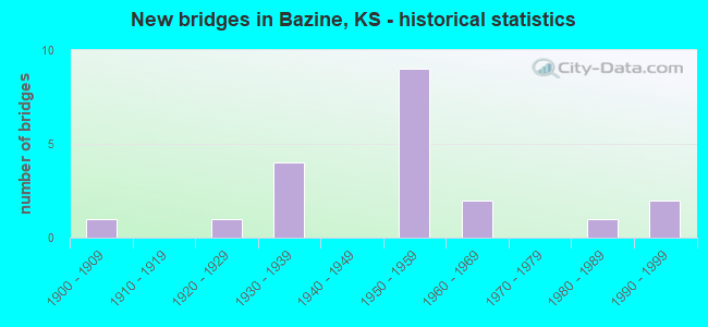
- New bridges - historical statistics
- 11900-1909
- 11920-1929
- 41930-1939
- 91950-1959
- 21960-1969
- 11980-1989
- 21990-1999

- Reconstructed bridges - Historical Statistics
- 11960-1969
- 11970-1979


- Bridge Condition - Deck
- 27.3%Good
- 45.5%Satisfactory
- 27.3%Fair

- Bridge Condition - Superstructure
- 9.1%Very good
- 18.2%Good
- 45.5%Satisfactory
- 18.2%Fair
- 9.1%Poor

- Bridge Condition - Substructure
- 9.1%Very good
- 27.3%Good
- 18.2%Satisfactory
- 27.3%Fair
- 18.2%Poor

- Bridge Condition - Channel
- 15.0%Very good
- 35.0%Good
- 45.0%Satisfactory
- 5.0%Fair

- Bridge Condition - Culverts
- 11.1%Very good
- 55.6%Good
- 11.1%Satisfactory
- 11.1%Serious
- 11.1%Critical
Find on map >> Show street view
Structure Number: 68026, Location: 2.0S OF BAZINE (Lat: 38.418583, Lng: -99.695833), Route carried "on" structure: County highway 314, Year Built: 1958, Status: Open, Structure Length: 0.94m (3.08ft), Average Daily Traffic: 155 (year 2018), Truck Traffic: 10%, Average Future Daily Traffic: 185 (year 2041), Design Load: H 15, Features Intersected: TRIB. TO WALNUT CREEK
Minimum Vertical Clearance: 30.47m (99.97ft), Kilometerpoint: 0.000, Lanes on structure: 2, Owner: County Highway Agency, Approaching Roadway Width: 6.6m (21.7ft), Material/Design: Concrete, Design/Construction: Culvert, Number Of Spans In Main Unit: 3, Length of Maximum Span: 3.0m (9.8ft), Curb or Sidewalk Widths: Left: 0.3m (1.0ft), Right: 0.3m (1.0ft), Curb-To-Curb Width: 8.5m (27.9ft), Out-to-Out Width: 9.1m (29.9ft)
Condition: Channel: Good, Culverts: Good, Operating Rating: 31.1 metric tons, Method Used To Determine Operating Rating: Load Factor (LF), Inventory Rating: 18.6 metric tons, Method Used To Determine Inventory Rating: Load Factor (LF), Structural Evaluation: Somewhat better than minimum adequacy, Deck Geometry: Equal to present minimum criteria, Waterway Adequacy: Better than present minimum criteria, Approach Roadway Alignment: Equal to present desirable criteria, Designated Inspection Frequency: Every 24 months, Inspection Date: November 2021, Deck Structure Type: Concrete Cast-file-Place
Find on map >> Show street view
Structure Number: 68027, Location: 1.4S OF BAZINE (Lat: 38.430250, Lng: -99.696028), Route carried "on" structure: County highway 314, Year Built: 1958, Status: Posted for load, Structure Length: 0.85m (2.79ft), Average Daily Traffic: 155 (year 2018), Truck Traffic: 10%, Average Future Daily Traffic: 185 (year 2041), Design Load: HS 20, Features Intersected: TRIB. TO WALNUT CREEK
Minimum Vertical Clearance: 30.47m (99.97ft), Kilometerpoint: 0.000, Lanes on structure: 1, Owner: County Highway Agency, Approaching Roadway Width: 6.5m (21.3ft), Skew: 4 degrees, Material/Design: Concrete, Design/Construction: Culvert, Number Of Spans In Main Unit: 1, Length of Maximum Span: 8.5m (27.9ft)
Condition: Channel: Good, Culverts: Good, Operating Rating: 36.3 metric tons, Method Used To Determine Operating Rating: Load Factor (LF), Inventory Rating: 22.7 metric tons, Method Used To Determine Inventory Rating: Load Factor (LF), Structural Evaluation: Equal to present minimum criteria, Waterway Adequacy: Better than present minimum criteria, Approach Roadway Alignment: Equal to present desirable criteria, Designated Inspection Frequency: Every 24 months, Inspection Date: November 2021, Other Special Inspection Date: January 2001, Deck Structure Type: Concrete Cast-file-Place
Find on map >> Show street view
Structure Number: 68028, Location: 1.2S OF BAZINE (Lat: 38.432833, Lng: -99.695917), Route carried "on" structure: County highway 314, Year Built: 1958, Status: Open, Structure Length: 6.40m (21.00ft), Average Daily Traffic: 155 (year 2018), Truck Traffic: 10%, Average Future Daily Traffic: 185 (year 2041), Design Load: H 15, Features Intersected: WALNUT CREEK
Minimum Vertical Clearance: 30.47m (99.97ft), Kilometerpoint: 0.000, Lanes on structure: 2, Owner: County Highway Agency, Approaching Roadway Width: 6.5m (21.3ft), Material/Design: Steel continuous, Design/Construction: Stringer/Multi-beam, Number Of Spans In Main Unit: 3, Length of Maximum Span: 24.4m (80.1ft), Curb or Sidewalk Widths: Left: 0.3m (1.0ft), Right: 0.3m (1.0ft), Curb-To-Curb Width: 7.3m (24.0ft), Out-to-Out Width: 8.0m (26.2ft)
Condition: Deck: Fair, Superstructure: Good, Substructure: Satisfactory, Channel: Satisfactory, Operating Rating: 33.9 metric tons, Method Used To Determine Operating Rating: Load Factor (LF), Inventory Rating: 20.3 metric tons, Method Used To Determine Inventory Rating: Load Factor (LF), Structural Evaluation: Somewhat better than minimum adequacy, Deck Geometry: Somewhat better than minimum adequacy, Waterway Adequacy: Better than present minimum criteria, Approach Roadway Alignment: Equal to present desirable criteria, Designated Inspection Frequency: Every 24 months, Inspection Date: November 2021, Deck Structure Type: Concrete Cast-file-Place
Find on map >> Show street view
Structure Number: 68029, Location: S. EDGE OF BAZINE (Lat: 38.438750, Lng: -99.696028), Route carried "on" structure: County highway 314, Year Built: 1958, Status: Posted for load, Structure Length: 4.21m (13.81ft), Average Daily Traffic: 155 (year 2018), Truck Traffic: 10%, Average Future Daily Traffic: 185 (year 2041), Design Load: H 15, Features Intersected: DRY CREEK
Minimum Vertical Clearance: 30.47m (99.97ft), Kilometerpoint: 0.000, Lanes on structure: 2, Owner: County Highway Agency, Approaching Roadway Width: 8.5m (27.9ft), Material/Design: Concrete continuous, Design/Construction: Tee Beam, Number Of Spans In Main Unit: 3, Length of Maximum Span: 15.8m (51.8ft), Curb or Sidewalk Widths: Left: 0.4m (1.3ft), Right: 0.4m (1.3ft), Curb-To-Curb Width: 7.3m (24.0ft), Out-to-Out Width: 8.0m (26.2ft)
Condition: Deck: Satisfactory, Superstructure: Satisfactory, Substructure: Good, Channel: Satisfactory, Operating Rating: 11.6 metric tons, Method Used To Determine Operating Rating: Load Factor (LF), Inventory Rating: 7.0 metric tons, Method Used To Determine Inventory Rating: Load Factor (LF), Structural Evaluation: High priority of replacement, Deck Geometry: Somewhat better than minimum adequacy, Waterway Adequacy: Better than present minimum criteria, Approach Roadway Alignment: Equal to present desirable criteria, Bridge Posting: Required (Relationship of Operating Rating to Maximum Legal Load: > 39.9% below), Length Of Structure Improvement: 4.57m (14.99ft), Designated Inspection Frequency: Every 24 months, Inspection Date: November 2021, Bridge Improvement Cost: $510,000, Roadway Improvement Cost: $180,000, Total Project Cost: $690,000 ( Estimate for 2021), Deck Structure Type: Concrete Cast-file-Place
Find on map >> Show street view
Structure Number: 6803, Location: 1.0N OF BAZINE (Lat: 38.465111, Lng: -99.696222), Route carried "on" structure: County highway 314, Year Built: 1957, Status: Posted for load, Structure Length: 0.62m (2.03ft), Average Daily Traffic: 110 (year 2018), Truck Traffic: 10%, Average Future Daily Traffic: 132 (year 2041), Design Load: H 15, Features Intersected: TRIB. TO WALNUT CREEK
Minimum Vertical Clearance: 30.47m (99.97ft), Kilometerpoint: 0.000, Lanes on structure: 2, Owner: County Highway Agency, Approaching Roadway Width: 7.6m (24.9ft), Material/Design: Concrete, Design/Construction: Culvert, Number Of Spans In Main Unit: 2, Length of Maximum Span: 3.0m (9.8ft), Curb or Sidewalk Widths: Left: 0.3m (1.0ft), Right: 0.3m (1.0ft), Curb-To-Curb Width: 8.5m (27.9ft), Out-to-Out Width: 9.1m (29.9ft)
Condition: Channel: Good, Culverts: Good, Operating Rating: 30.6 metric tons, Method Used To Determine Operating Rating: Load Factor (LF), Inventory Rating: 18.3 metric tons, Method Used To Determine Inventory Rating: Load Factor (LF), Structural Evaluation: Somewhat better than minimum adequacy, Deck Geometry: Equal to present minimum criteria, Waterway Adequacy: Equal to present minimum criteria, Approach Roadway Alignment: Equal to present desirable criteria, Bridge Posting: Required (Relationship of Operating Rating to Maximum Legal Load: 30.0 - 39.9% below), Designated Inspection Frequency: Every 24 months, Inspection Date: November 2021, Deck Structure Type: Concrete Cast-file-Place
Find on map >> Show street view
Structure Number: 68031, Location: 2.0N OF BAZINE (Lat: 38.477639, Lng: -99.696250), Route carried "on" structure: County highway 314, Year Built: 1957, Status: Posted for load, Structure Length: 3.15m (10.33ft), Average Daily Traffic: 110 (year 2018), Truck Traffic: 10%, Average Future Daily Traffic: 130 (year 2041), Design Load: H 15, Features Intersected: TRIB. TO WALNUT CREEK
Minimum Vertical Clearance: 30.47m (99.97ft), Kilometerpoint: 0.000, Lanes on structure: 2, Owner: County Highway Agency, Approaching Roadway Width: 7.6m (24.9ft), Material/Design: Concrete, Design/Construction: Culvert, Number Of Spans In Main Unit: 5, Length of Maximum Span: 6.1m (20.0ft), Curb or Sidewalk Widths: Left: 0.5m (1.6ft), Right: 0.5m (1.6ft), Curb-To-Curb Width: 8.7m (28.5ft), Out-to-Out Width: 9.6m (31.5ft)
Condition: Channel: Good, Culverts: Good, Operating Rating: 36.9 metric tons, Method Used To Determine Operating Rating: Load Factor (LF), Inventory Rating: 22.1 metric tons, Method Used To Determine Inventory Rating: Load Factor (LF), Structural Evaluation: Equal to present minimum criteria, Deck Geometry: Equal to present minimum criteria, Waterway Adequacy: Equal to present desirable criteria, Approach Roadway Alignment: Equal to present desirable criteria, Bridge Posting: Required (Relationship of Operating Rating to Maximum Legal Load: 30.0 - 39.9% below), Designated Inspection Frequency: Every 24 months, Inspection Date: November 2021, Deck Structure Type: Concrete Cast-file-Place
Find on map >> Show street view
Structure Number: 7701, Location: 0.5S 1.0W OF HERNDON (Lat: 39.900722, Lng: -100.810111), Route carried "on" structure: County highway 179, Year Built: 1924, Status: Posted for load, Structure Length: 1.13m (3.71ft), Average Daily Traffic: 70 (year 2014), Average Future Daily Traffic: 80 (year 2040), Design Load: H 15, Features Intersected: BEAVER CREEK
Minimum Vertical Clearance: 30.47m (99.97ft), Kilometerpoint: 22.531, Lanes on structure: 2, Owner: County Highway Agency, Approaching Roadway Width: 6.7m (22.0ft), Material/Design: Concrete, Design/Construction: Stringer/Multi-beam, Number Of Spans In Main Unit: 1, Length of Maximum Span: 10.4m (34.1ft), Curb-To-Curb Width: 6.2m (20.3ft), Out-to-Out Width: 7.0m (23.0ft)
Condition: Deck: Fair, Superstructure: Satisfactory, Substructure: Fair, Channel: Satisfactory, Operating Rating: 26.3 metric tons, Method Used To Determine Operating Rating: Allowable Stress (AS), Inventory Rating: 19.1 metric tons, Method Used To Determine Inventory Rating: Allowable Stress (AS), Structural Evaluation: Somewhat better than minimum adequacy, Deck Geometry: Somewhat better than minimum adequacy, Waterway Adequacy: Meets minimum limits, Approach Roadway Alignment: Better than present minimum criteria, Length Of Structure Improvement: 1.28m (4.20ft), Designated Inspection Frequency: Every 24 months, Inspection Date: November 2020, Bridge Improvement Cost: $140,000, Roadway Improvement Cost: $28,000, Total Project Cost: $210,000, Deck Structure Type: Concrete Cast-file-Place, Wearing Surface/Protective System: Wearing Surface: Gravel
Find on map >> Show street view
Structure Number: 680559005169, Location: 2.9W 1.9S OF BAZINE (Lat: 38.424889, Lng: -99.751056), Route carried "on" structure: County highway , Year Built: 1984, Status: Open, Structure Length: 5.58m (18.31ft), Average Daily Traffic: 50 (year 2018), Truck Traffic: 5%, Average Future Daily Traffic: 50 (year 2041), Design Load: HS 20, Features Intersected: WALNUT CREEK, Facility Carried by Structure: LCL RD 97 (RD AA)
Minimum Vertical Clearance: 30.47m (99.97ft), Kilometerpoint: 0.000, Lanes on structure: 2, Owner: County Highway Agency, Approaching Roadway Width: 6.4m (21.0ft), Skew: 3 degrees, Material/Design: Concrete continuous, Design/Construction: Tee Beam, Number Of Spans In Main Unit: 3, Length of Maximum Span: 22.6m (74.1ft), Curb or Sidewalk Widths: Left: 0.3m (1.0ft), Right: 0.3m (1.0ft), Curb-To-Curb Width: 8.5m (27.9ft), Out-to-Out Width: 9.1m (29.9ft)
Condition: Deck: Good, Superstructure: Good, Substructure: Good, Channel: Satisfactory, Operating Rating: 50.4 metric tons, Method Used To Determine Operating Rating: Load Factor (LF), Inventory Rating: 25.4 metric tons, Method Used To Determine Inventory Rating: Load Factor (LF), Structural Evaluation: Equal to present minimum criteria, Deck Geometry: Better than present minimum criteria, Waterway Adequacy: Equal to present desirable criteria, Approach Roadway Alignment: Equal to present desirable criteria, Designated Inspection Frequency: Every 24 months, Inspection Date: November 2021, Other Special Inspection Date: January 2001, Deck Structure Type: Concrete Cast-file-Place
Find on map >> Show street view
Structure Number: 68055960518, Location: 2.0S K-96 8.6E US-283 (Lat: 38.421611, Lng: -99.738917), Route carried "on" structure: County highway , Year Built: 1935, Status: Posted for load, Structure Length: 0.94m (3.08ft), Average Daily Traffic: 50 (year 2018), Truck Traffic: 5%, Average Future Daily Traffic: 60 (year 2041), Features Intersected: CREEK, Facility Carried by Structure: LCL RD 18 (RD 110)
Minimum Vertical Clearance: 30.47m (99.97ft), Kilometerpoint: 0.000, Lanes on structure: 2, Owner: County Highway Agency, Approaching Roadway Width: 7.0m (23.0ft), Material/Design: Masonry, Design/Construction: Culvert, Number Of Spans In Main Unit: 3, Length of Maximum Span: 2.7m (8.9ft), Curb or Sidewalk Widths: Left: 0.3m (1.0ft), Right: 0.3m (1.0ft), Curb-To-Curb Width: 7.6m (24.9ft), Out-to-Out Width: 8.2m (26.9ft)
Condition: Channel: Good, Culverts: Serious, Operating Rating: 10.3 metric tons, Method Used To Determine Operating Rating: Allowable Stress (AS), Inventory Rating: 10.3 metric tons, Method Used To Determine Inventory Rating: Allowable Stress (AS), Structural Evaluation: High priority of replacement, Deck Geometry: Equal to present minimum criteria, Waterway Adequacy: Somewhat better than minimum adequacy, Approach Roadway Alignment: Equal to present desirable criteria, Bridge Posting: Required (Relationship of Operating Rating to Maximum Legal Load: 30.0 - 39.9% below), Length Of Structure Improvement: 1.22m (4.00ft), Designated Inspection Frequency: Every 12 months, Inspection Date: November 2021, Bridge Improvement Cost: $180,000, Roadway Improvement Cost: $80,000, Total Project Cost: $260,000 ( Estimate for 2021), Wearing Surface/Protective System: Wearing Surface: Gravel
Find on map >> Show street view
Structure Number: 68055970512, Location: 1.0N 2.3W OF BAZINE (Lat: 38.465583, Lng: -99.741389), Route carried "on" structure: County highway , Year Built: 1950, Status: Posted for load, Structure Length: 1.80m (5.91ft), Average Daily Traffic: 40 (year 2018), Truck Traffic: 5%, Average Future Daily Traffic: 45 (year 2041), Design Load: HS 20, Features Intersected: BAZINE DRY CREEK, Facility Carried by Structure: LCL RD 33 (RD 140)
Minimum Vertical Clearance: 30.47m (99.97ft), Kilometerpoint: 0.000, Lanes on structure: 2, Owner: County Highway Agency, Approaching Roadway Width: 5.4m (17.7ft), Material/Design: Wood or Timber, Design/Construction: Stringer/Multi-beam, Number Of Spans In Main Unit: 3, Length of Maximum Span: 5.9m (19.4ft), Curb-To-Curb Width: 5.9m (19.4ft), Out-to-Out Width: 6.1m (20.0ft)
Condition: Deck: Satisfactory, Superstructure: Fair, Substructure: Poor, Channel: Satisfactory, Operating Rating: 17.0 metric tons, Method Used To Determine Operating Rating: Load Factor (LF), Inventory Rating: 12.4 metric tons, Method Used To Determine Inventory Rating: Load Factor (LF), Structural Evaluation: Meets minimum limits, Deck Geometry: Meets minimum limits, Waterway Adequacy: Equal to present minimum criteria, Approach Roadway Alignment: Better than present minimum criteria, Bridge Posting: Required (Relationship of Operating Rating to Maximum Legal Load: > 39.9% below), Length Of Structure Improvement: 1.83m (6.00ft), Designated Inspection Frequency: Every 24 months, Inspection Date: November 2021, Bridge Improvement Cost: $270,000, Roadway Improvement Cost: $120,000, Total Project Cost: $390,000 ( Estimate for 2021), Deck Structure Type: Wood or Timber, Wearing Surface/Protective System: Wearing Surface: Gravel
Find on map >> Show street view
Structure Number: 680561005163, Location: 2.0W 1.3S OF BAZINE (Lat: 38.433056, Lng: -99.733222), Route carried "on" structure: County highway , Year Built: 1968, Status: Posted for load, Structure Length: 3.05m (10.01ft), Average Daily Traffic: 40 (year 2018), Truck Traffic: 5%, Average Future Daily Traffic: 50 (year 2041), Design Load: HS 20, Features Intersected: WALNUT CREEK, Facility Carried by Structure: LCL RD 54 (RD BB)
Minimum Vertical Clearance: 30.47m (99.97ft), Kilometerpoint: 0.000, Lanes on structure: 2, Owner: County Highway Agency, Approaching Roadway Width: 5.8m (19.0ft), Material/Design: Prestressed concrete, Design/Construction: Tee Beam, Number Of Spans In Main Unit: 3, Length of Maximum Span: 12.2m (40.0ft), Curb-To-Curb Width: 7.3m (24.0ft), Out-to-Out Width: 7.3m (24.0ft)
Condition: Deck: Good, Superstructure: Satisfactory, Substructure: Satisfactory, Channel: Satisfactory, Operating Rating: 36.3 metric tons, Method Used To Determine Operating Rating: Load Factor (LF), Inventory Rating: 22.7 metric tons, Method Used To Determine Inventory Rating: Load Factor (LF), Structural Evaluation: Equal to present minimum criteria, Deck Geometry: Equal to present minimum criteria, Waterway Adequacy: Equal to present minimum criteria, Approach Roadway Alignment: Meets minimum limits, Designated Inspection Frequency: Every 24 months, Inspection Date: November 2021, Other Special Inspection Date: January 2001, Deck Structure Type: Concrete Cast-file-Place
Find on map >> Show street view
Structure Number: 68056150518, Location: 2.0S K-96 9.5E US-283 (Lat: 38.421667, Lng: -99.723861), Route carried "on" structure: County highway , Year Built: 1935, Status: Posted for load, Structure Length: 1.01m (3.31ft), Average Daily Traffic: 50 (year 2018), Truck Traffic: 5%, Average Future Daily Traffic: 60 (year 2041), Features Intersected: CREEK, Facility Carried by Structure: LCL RD 19 (RD 110)
Minimum Vertical Clearance: 30.47m (99.97ft), Kilometerpoint: 0.000, Lanes on structure: 2, Owner: County Highway Agency, Approaching Roadway Width: 6.2m (20.3ft), Material/Design: Masonry, Design/Construction: Culvert, Number Of Spans In Main Unit: 3, Length of Maximum Span: 2.7m (8.9ft), Curb or Sidewalk Widths: Left: 0.5m (1.6ft), Right: 0.5m (1.6ft), Curb-To-Curb Width: 7.4m (24.3ft), Out-to-Out Width: 8.4m (27.6ft)
Condition: Channel: Satisfactory, Culverts: Critical, Operating Rating: 11.4 metric tons, Method Used To Determine Operating Rating: Allowable Stress (AS), Inventory Rating: 11.4 metric tons, Method Used To Determine Inventory Rating: Allowable Stress (AS), Structural Evaluation: High priority of replacement, Deck Geometry: Equal to present minimum criteria, Waterway Adequacy: Equal to present minimum criteria, Approach Roadway Alignment: Better than present minimum criteria, Bridge Posting: Required (Relationship of Operating Rating to Maximum Legal Load: 30.0 - 39.9% below), Length Of Structure Improvement: 1.22m (4.00ft), Designated Inspection Frequency: Every 12 months, Inspection Date: November 2021, Bridge Improvement Cost: $180,000, Roadway Improvement Cost: $80,000, Total Project Cost: $260,000 ( Estimate for 2021)
Find on map >> Show street view
Structure Number: 68056390512, Location: 1.0N 0.1W OF BAZINE (Lat: 38.465667, Lng: -99.696639), Route carried "on" structure: County highway , Year Built: 1960, Status: Posted for load, Structure Length: 0.76m (2.49ft), Average Daily Traffic: 40 (year 2018), Truck Traffic: 5%, Average Future Daily Traffic: 50 (year 2041), Design Load: HS 20, Features Intersected: CREEK, Facility Carried by Structure: LOCAL RD 34 140 RD
Minimum Vertical Clearance: 30.47m (99.97ft), Kilometerpoint: 0.000, Lanes on structure: 2, Owner: County Highway Agency, Approaching Roadway Width: 6.0m (19.7ft), Material/Design: Concrete, Design/Construction: Culvert, Number Of Spans In Main Unit: 3, Length of Maximum Span: 2.4m (7.9ft), Curb or Sidewalk Widths: Left: 0.3m (1.0ft), Right: 0.3m (1.0ft), Curb-To-Curb Width: 8.5m (27.9ft), Out-to-Out Width: 9.1m (29.9ft)
Condition: Channel: Good, Culverts: Good, Operating Rating: 36.3 metric tons, Method Used To Determine Operating Rating: Load Factor (LF), Inventory Rating: 22.7 metric tons, Method Used To Determine Inventory Rating: Load Factor (LF), Structural Evaluation: Equal to present minimum criteria, Deck Geometry: Better than present minimum criteria, Waterway Adequacy: Better than present minimum criteria, Approach Roadway Alignment: Equal to present desirable criteria, Designated Inspection Frequency: Every 24 months, Inspection Date: November 2021, Other Special Inspection Date: January 2001, Deck Structure Type: Concrete Cast-file-Place
Find on map >> Show street view
Structure Number: 680565505145, Location: 0.1E BAZINE 0.5S OF K-96 (Lat: 38.442417, Lng: -99.687389), Route carried "on" structure: County highway , Year Built: 1905, Year Reconstructed: 1982, Status: Posted for load, Structure Length: 6.71m (22.01ft), Average Daily Traffic: 60 (year 2018), Truck Traffic: 5%, Average Future Daily Traffic: 72 (year 2041), Design Load: HS 20, Features Intersected: WALNUT CREEK, Facility Carried by Structure: LCL RD 66 (E 125)
Minimum Vertical Clearance: 4.90m (16.08ft), Kilometerpoint: 0.000, Lanes on structure: 2, Owner: County Highway Agency, Approaching Roadway Width: 5.4m (17.7ft), Material/Design: Steel, Design/Construction: Truss - Thru, Number Of Spans In Main Unit: 2, Number Of Approach Spans: 2, Length of Maximum Span: 24.4m (80.1ft), Curb-To-Curb Width: 4.9m (16.1ft), Out-to-Out Width: 4.9m (16.1ft)
Condition: Deck: Fair, Superstructure: Poor, Substructure: Fair, Channel: Satisfactory, Operating Rating: 5.9 metric tons, Method Used To Determine Operating Rating: Load Factor (LF), Inventory Rating: 3.6 metric tons, Method Used To Determine Inventory Rating: Load Factor (LF), Structural Evaluation: High priority of replacement, Deck Geometry: High priority of replacement, Waterway Adequacy: Equal to present desirable criteria, Approach Roadway Alignment: High priority of corrective action, Bridge Posting: Required (Relationship of Operating Rating to Maximum Legal Load: > 39.9% below), Length Of Structure Improvement: 7.32m (24.02ft), Designated Inspection Frequency: Every 24 months, Critical Feature Inspection Frequency: Every 24 months, Inspection Date: November 2021, Critical Feature Inspection Date: December 2020, Bridge Improvement Cost: $880,000, Roadway Improvement Cost: $310,000, Total Project Cost: $1,000 ( Estimate for 2021), Deck Structure Type: Corrugated Steel
Find on map >> Show street view
Structure Number: 680567605165, Location: 1.5S K-96 4.4W CO. LINE (Lat: 38.429361, Lng: -99.663806), Route carried "on" structure: County highway , Year Built: 1955, Status: Posted for load, Structure Length: 1.16m (3.81ft), Average Daily Traffic: 40 (year 2018), Truck Traffic: 5%, Average Future Daily Traffic: 40 (year 2041), Design Load: HS 20, Features Intersected: CREEK, Facility Carried by Structure: LCL RD 35 (RD 115)
Minimum Vertical Clearance: 30.47m (99.97ft), Kilometerpoint: 0.000, Lanes on structure: 2, Owner: County Highway Agency, Approaching Roadway Width: 5.1m (16.7ft), Material/Design: Wood or Timber, Design/Construction: Stringer/Multi-beam, Number Of Spans In Main Unit: 2, Length of Maximum Span: 5.5m (18.0ft), Curb-To-Curb Width: 6.1m (20.0ft), Out-to-Out Width: 6.1m (20.0ft)
Condition: Deck: Satisfactory, Superstructure: Satisfactory, Substructure: Poor, Channel: Fair, Operating Rating: 29.5 metric tons, Method Used To Determine Operating Rating: Load Factor (LF), Inventory Rating: 21.0 metric tons, Method Used To Determine Inventory Rating: Load Factor (LF), Structural Evaluation: Meets minimum limits, Deck Geometry: Somewhat better than minimum adequacy, Waterway Adequacy: Meets minimum limits, Approach Roadway Alignment: Equal to present desirable criteria, Length Of Structure Improvement: 1.22m (4.00ft), Designated Inspection Frequency: Every 24 months, Inspection Date: November 2021, Bridge Improvement Cost: $180,000, Roadway Improvement Cost: $80,000, Total Project Cost: $260,000 ( Estimate for 2021), Deck Structure Type: Wood or Timber, Wearing Surface/Protective System: Wearing Surface: Gravel
Find on map >> Show street view
Structure Number: 68056920514, Location: 2.2E OF BAZINE (Lat: 38.451806, Lng: -99.659444), Route carried "on" structure: County highway , Year Built: 1935, Status: Open, Structure Length: 1.40m (4.59ft), Average Daily Traffic: 5 (year 2018), Average Future Daily Traffic: 5 (year 2041), Design Load: HS 20, Features Intersected: CREEK, Facility Carried by Structure: Field entrance
Minimum Vertical Clearance: 30.47m (99.97ft), Kilometerpoint: 0.000, Lanes on structure: 2, Owner: County Highway Agency, Approaching Roadway Width: 6.0m (19.7ft), Material/Design: Concrete, Design/Construction: Culvert, Number Of Spans In Main Unit: 6, Length of Maximum Span: 2.1m (6.9ft), Curb-To-Curb Width: 9.6m (31.5ft), Out-to-Out Width: 10.3m (33.8ft)
Condition: Channel: Satisfactory, Culverts: Satisfactory, Operating Rating: 36.3 metric tons, Method Used To Determine Operating Rating: Load Factor (LF), Inventory Rating: 22.7 metric tons, Method Used To Determine Inventory Rating: Load Factor (LF), Structural Evaluation: Equal to present minimum criteria, Deck Geometry: Better than present minimum criteria, Waterway Adequacy: Somewhat better than minimum adequacy, Approach Roadway Alignment: Equal to present minimum criteria, Designated Inspection Frequency: Every 24 months, Inspection Date: November 2021, Other Special Inspection Date: January 2001, Deck Structure Type: Concrete Cast-file-Place
Find on map >> Show street view
Structure Number: 999909600680421, Location: 10.71 MI. EAST OF US-283 (Lat: 38.451111, Lng: -99.707778), Route carried "on" structure: State highway 96, Year Built: 1930, Year Reconstructed: 1966, Status: Open, Structure Length: 5.94m (19.49ft), Average Daily Traffic: 1,362 (year 2020), Truck Traffic: 16%, Average Future Daily Traffic: 1,475 (year 2041), Design Load: H 15, Features Intersected: BAZINE DRY CREEK
Minimum Vertical Clearance: 30.47m (99.97ft), Kilometerpoint: 47.756, Lanes on structure: 2, Base Highway Network: Yes, Owner: State Highway Agency, Approaching Roadway Width: 8.5m (27.9ft), Material/Design: Concrete, Design/Construction: Tee Beam, Number Of Spans In Main Unit: 6, Length of Maximum Span: 9.1m (29.9ft), Curb-To-Curb Width: 13.4m (44.0ft), Out-to-Out Width: 14.0m (45.9ft)
Condition: Deck: Satisfactory, Superstructure: Satisfactory, Substructure: Fair, Channel: Good, Operating Rating: 55.3 metric tons, Method Used To Determine Operating Rating: Load Factor (LF), Inventory Rating: 33.6 metric tons, Method Used To Determine Inventory Rating: Load Factor (LF), Structural Evaluation: Somewhat better than minimum adequacy, Deck Geometry: Equal to present desirable criteria, Waterway Adequacy: Better than present minimum criteria, Approach Roadway Alignment: Better than present minimum criteria, Length Of Structure Improvement: 19.50m (63.98ft), Designated Inspection Frequency: Every 24 months, Inspection Date: May 2021, Deck Structure Type: Concrete Cast-file-Place, Wearing Surface/Protective System: Wearing Surface: Bituminous
Find on map >> Show street view
Structure Number: 999909600680431, Location: 12.83 MI. EAST OF US-283 (Lat: 38.451667, Lng: -99.668333), Route carried "on" structure: State highway 96, Year Built: 1953, Status: Open, Structure Length: 4.75m (15.58ft), Average Daily Traffic: 1,145 (year 2020), Truck Traffic: 31%, Average Future Daily Traffic: 1,240 (year 2041), Design Load: H 20, Features Intersected: WALNUT CREEK DRAINAGE
Minimum Vertical Clearance: 30.47m (99.97ft), Kilometerpoint: 51.193, Lanes on structure: 2, Base Highway Network: Yes, Owner: State Highway Agency, Approaching Roadway Width: 9.1m (29.9ft), Material/Design: Concrete continuous, Design/Construction: Tee Beam, Number Of Spans In Main Unit: 3, Length of Maximum Span: 19.2m (63.0ft), Curb-To-Curb Width: 7.9m (25.9ft), Out-to-Out Width: 9.6m (31.5ft)
Condition: Deck: Satisfactory, Superstructure: Fair, Substructure: Good, Channel: Very good, Operating Rating: 42.6 metric tons, Method Used To Determine Operating Rating: Load Factor (LF), Inventory Rating: 24.9 metric tons, Method Used To Determine Inventory Rating: Load Factor (LF), Structural Evaluation: Somewhat better than minimum adequacy, Deck Geometry: Meets minimum limits, Waterway Adequacy: Equal to present minimum criteria, Approach Roadway Alignment: Equal to present minimum criteria, Length Of Structure Improvement: 15.58m (51.12ft), Designated Inspection Frequency: Every 24 months, Inspection Date: May 2021, Deck Structure Type: Concrete Cast-file-Place, Wearing Surface/Protective System: Wearing Surface: Low Slump Concrete
Find on map >> Show street view
Structure Number: 999909600680511, Location: 2.4 MI E OF BAZINE ECL (Lat: 38.452778, Lng: -99.644444), Route carried "on" structure: State highway 96, Year Built: 1998, Status: Open, Structure Length: 6.11m (20.05ft), Average Daily Traffic: 1,145 (year 2020), Truck Traffic: 31%, Average Future Daily Traffic: 1,240 (year 2041), Design Load: HS 20, Features Intersected: WALNUT CREEK
Minimum Vertical Clearance: 30.47m (99.97ft), Kilometerpoint: 53.301, Lanes on structure: 2, Base Highway Network: Yes, Owner: State Highway Agency, Approaching Roadway Width: 9.1m (29.9ft), Material/Design: Prestressed concrete continuous, Design/Construction: Stringer/Multi-beam, Number Of Spans In Main Unit: 3, Length of Maximum Span: 20.3m (66.6ft), Curb-To-Curb Width: 11.0m (36.1ft), Out-to-Out Width: 11.6m (38.1ft)
Condition: Deck: Good, Superstructure: Very good, Substructure: Very good, Channel: Very good, Operating Rating: 70.3 metric tons, Method Used To Determine Operating Rating: Load Factor (LF), Inventory Rating: 42.1 metric tons, Method Used To Determine Inventory Rating: Load Factor (LF), Structural Evaluation: Equal to present desirable criteria, Deck Geometry: Equal to present minimum criteria, Waterway Adequacy: Equal to present desirable criteria, Approach Roadway Alignment: Meets minimum limits, Length Of Structure Improvement: 20.05m (65.78ft), Designated Inspection Frequency: Every 24 months, Inspection Date: May 2021, Wearing Surface/Protective System: Wearing Surface: Monolithic Concrete, Deck Protection: Epoxy Coated Reinforcing
Find on map >> Show street view
Structure Number: 999909600680521, Location: 2.5 MI E OF BAZINE ECL (Lat: 38.452500, Lng: -99.642778), Route carried "on" structure: State highway 96, Year Built: 1998, Status: Open, Structure Length: 0.77m (2.53ft), Average Daily Traffic: 1,145 (year 2020), Truck Traffic: 31%, Average Future Daily Traffic: 1,240 (year 2041), Design Load: HS 20, Features Intersected: WALNUT CREEK DRAINAGE
Minimum Vertical Clearance: 30.47m (99.97ft), Kilometerpoint: 53.448, Lanes on structure: 2, Base Highway Network: Yes, Owner: State Highway Agency, Approaching Roadway Width: 9.1m (29.9ft), Material/Design: Concrete, Design/Construction: Culvert, Number Of Spans In Main Unit: 3, Length of Maximum Span: 2.4m (7.9ft), Curb-To-Curb Width: 9.1m (29.9ft), Out-to-Out Width: 25.9m (85.0ft)
Condition: Channel: Very good, Culverts: Very good, Operating Rating: 78.4 metric tons, Method Used To Determine Operating Rating: Load Factor (LF), Inventory Rating: 46.9 metric tons, Method Used To Determine Inventory Rating: Load Factor (LF), Structural Evaluation: Equal to present desirable criteria, Deck Geometry: Somewhat better than minimum adequacy, Waterway Adequacy: Equal to present desirable criteria, Approach Roadway Alignment: Somewhat better than minimum adequacy, Length Of Structure Improvement: 2.52m (8.27ft), Designated Inspection Frequency: Every 24 months, Inspection Date: May 2021, Deck Structure Type: Concrete Cast-file-Place, Wearing Surface/Protective System: Wearing Surface: Bituminous