Bridge Statistics for Beal City, Michigan (MI)
Condition, Traffic, Stress, Structural Evaluation, Project Costs
- National Bridge Inventory (NBI) Statistics
- 19Number of bridges
- 125ft / 37.8mTotal length
- $1,337,000Total costs
- 43,884Total average daily traffic
- 3,962Total average daily truck traffic
- 57,433Total future (year 2022) average daily traffic
- National Bridge Inventory (NBI) Registered Bridges for Beal City
- No street view available for this location
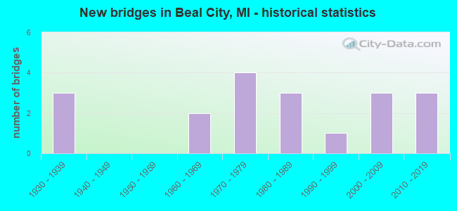
- New bridges - historical statistics
- 31930-1939
- 21960-1969
- 41970-1979
- 31980-1989
- 11990-1999
- 32000-2009
- 32010-2019


- Bridge Condition - Deck
- 16.7%Very good
- 38.9%Good
- 27.8%Satisfactory
- 5.6%Fair
- 5.6%Poor
- 5.6%Critical

- Bridge Condition - Superstructure
- 38.9%Very good
- 22.2%Good
- 16.7%Satisfactory
- 16.7%Fair
- 5.6%Critical

- Bridge Condition - Substructure
- 33.3%Very good
- 27.8%Good
- 27.8%Satisfactory
- 5.6%Fair
- 5.6%Poor

- Bridge Condition - Channel
- 16.7%Very good
- 33.3%Good
- 33.3%Satisfactory
- 11.1%Fair
- 5.6%Poor
Find on map >> Show street view
Structure Number: 97, Location: 0.5 MI S OF BARODA (Lat: 41.942875, Lng: -86.485061), Route carried "on" structure: County highway 1136, Year Built: 2000, Status: Open, Structure Length: 0.78m (2.56ft), Average Daily Traffic: 3,179 (year 2007), Truck Traffic: 4%, Average Future Daily Traffic: 4,500 (year 2027), Design Load: HS 20, Features Intersected: FOWLER DRAIN, Facility Carried by Structure: SHAWNEE ROAD
Minimum Vertical Clearance: 30.48m (100.00ft), Kilometerpoint: 6.499, Lanes on structure: 2, Owner: County Highway Agency, Approaching Roadway Width: 10.4m (34.1ft), Material/Design: Concrete, Design/Construction: Culvert, Number Of Spans In Main Unit: 1, Length of Maximum Span: 7.3m (24.0ft), Curb-To-Curb Width: 10.4m (34.1ft), Out-to-Out Width: 10.8m (35.4ft)
Condition: Channel: Satisfactory, Culverts: Good, Operating Rating: 54.5 metric tons, Method Used To Determine Operating Rating: Field evaluation and documented engineering judgment, Inventory Rating: 32.7 metric tons, Method Used To Determine Inventory Rating: Field evaluation and documented engineering judgment, Structural Evaluation: Better than present minimum criteria, Deck Geometry: Somewhat better than minimum adequacy, Waterway Adequacy: Equal to present desirable criteria, Approach Roadway Alignment: Equal to present desirable criteria, Designated Inspection Frequency: Every 24 months, Inspection Date: June 2020, Wearing Surface/Protective System: Wearing Surface: Bituminous
Find on map >> Show street view
Structure Number: 974, Location: 2.0 MI E OF SODUS (Lat: 42.043497, Lng: -86.347358), Route carried "on" structure: County highway 1158, Year Built: 1980, Status: Open, Structure Length: 1.22m (4.00ft), Average Daily Traffic: 1,647 (year 2007), Truck Traffic: 4%, Average Future Daily Traffic: 2,000 (year 2027), Design Load: HS 20, Features Intersected: PIPESTONE CREEK, Facility Carried by Structure: NAOMI ROAD
Minimum Vertical Clearance: 30.48m (100.00ft), Kilometerpoint: 4.159, Lanes on structure: 2, Owner: County Highway Agency, Approaching Roadway Width: 12.2m (40.0ft), Skew: 2 degrees, Material/Design: Prestressed concrete, Design/Construction: Box Beam or Girders - Multiple, Number Of Spans In Main Unit: 1, Length of Maximum Span: 11.5m (37.7ft), Curb-To-Curb Width: 11.0m (36.1ft), Out-to-Out Width: 11.4m (37.4ft)
Condition: Deck: Very good, Superstructure: Very good, Substructure: Satisfactory, Channel: Satisfactory, Operating Rating: 56.7 metric tons, Method Used To Determine Operating Rating: Load Factor (LF) rating reported by rating factor (RF) method using MS18 loading, Inventory Rating: 34.0 metric tons, Method Used To Determine Inventory Rating: Load Factor (LF) rating reported by rating factor (RF) method using MS18 loading, Structural Evaluation: Equal to present minimum criteria, Deck Geometry: Equal to present minimum criteria, Waterway Adequacy: Better than present minimum criteria, Approach Roadway Alignment: Equal to present desirable criteria, Designated Inspection Frequency: Every 24 months, Inspection Date: June 2020, Deck Structure Type: Concrete Precast Panels, Wearing Surface/Protective System: Wearing Surface: Bituminous, Membrane: Built-up
Find on map >> Show street view
Structure Number: 977, Location: 3.0 MI W OF COLOMA (Lat: 42.186117, Lng: -86.368767), Route carried "on" structure: County highway 1182, Year Built: 1966, Status: Open, Structure Length: 4.78m (15.68ft), Average Daily Traffic: 4,366 (year 2007), Truck Traffic: 8%, Average Future Daily Traffic: 7,000 (year 2027), Design Load: HS 20, Features Intersected: PAW PAW RIVER, Facility Carried by Structure: COLOMA ROAD
Minimum Vertical Clearance: 30.48m (100.00ft), Kilometerpoint: 3.299, Lanes on structure: 2, Owner: County Highway Agency, Approaching Roadway Width: 13.4m (44.0ft), Skew: 1 degrees, Material/Design: Steel continuous, Design/Construction: Stringer/Multi-beam, Number Of Spans In Main Unit: 3, Length of Maximum Span: 17.6m (57.7ft), Curb or Sidewalk Widths: Left: 0.7m (2.3ft), Right: 0.7m (2.3ft), Curb-To-Curb Width: 9.1m (29.9ft), Out-to-Out Width: 11.4m (37.4ft)
Condition: Deck: Fair, Superstructure: Satisfactory, Substructure: Satisfactory, Channel: Satisfactory, Operating Rating: 53.8 metric tons, Method Used To Determine Operating Rating: Load Factor (LF) rating reported by rating factor (RF) method using MS18 loading, Inventory Rating: 32.4 metric tons, Method Used To Determine Inventory Rating: Load Factor (LF) rating reported by rating factor (RF) method using MS18 loading, Structural Evaluation: Equal to present minimum criteria, Deck Geometry: Meets minimum limits, Waterway Adequacy: Equal to present desirable criteria, Approach Roadway Alignment: Equal to present minimum criteria, Length Of Structure Improvement: 4.79m (15.72ft), Designated Inspection Frequency: Every 24 months, Underwater Inspection Frequency: Every 60 months, Inspection Date: June 2020, Underwater Inspection Date: June 2018, Bridge Improvement Cost: $100,000, Roadway Improvement Cost: $50,000, Total Project Cost: $150,000, Deck Structure Type: Concrete Cast-file-Place, Wearing Surface/Protective System: Wearing Surface: Latex Concrete
Find on map >> Show street view
Structure Number: 981, Location: 1.75 MI S OF LAKESIDE (Lat: 41.825336, Lng: -86.668256), Route carried "on" structure: County highway 1113, Year Built: 1982, Status: Open, Structure Length: 2.43m (7.97ft), Average Daily Traffic: 653 (year 2007), Truck Traffic: 4%, Average Future Daily Traffic: 1,000 (year 2027), Design Load: HS 20, Features Intersected: GALIEN RIVER, Facility Carried by Structure: LAKESIDE ROAD
Minimum Vertical Clearance: 30.48m (100.00ft), Kilometerpoint: 7.316, Lanes on structure: 2, Owner: County Highway Agency, Approaching Roadway Width: 8.5m (27.9ft), Material/Design: Prestressed concrete, Design/Construction: Box Beam or Girders - Multiple, Number Of Spans In Main Unit: 1, Length of Maximum Span: 23.4m (76.8ft), Curb-To-Curb Width: 8.5m (27.9ft), Out-to-Out Width: 8.8m (28.9ft)
Condition: Deck: Good, Superstructure: Good, Substructure: Good, Channel: Poor, Operating Rating: 70.0 metric tons, Method Used To Determine Operating Rating: Load Factor (LF) rating reported by rating factor (RF) method using MS18 loading, Inventory Rating: 41.8 metric tons, Method Used To Determine Inventory Rating: Load Factor (LF) rating reported by rating factor (RF) method using MS18 loading, Structural Evaluation: Better than present minimum criteria, Deck Geometry: Somewhat better than minimum adequacy, Waterway Adequacy: Equal to present minimum criteria, Approach Roadway Alignment: Equal to present desirable criteria, Length Of Structure Improvement: 2.44m (8.01ft), Designated Inspection Frequency: Every 24 months, Inspection Date: April 2020, Bridge Improvement Cost: $33,000, Roadway Improvement Cost: $5,000, Total Project Cost: $38,000, Deck Structure Type: Concrete Precast Panels, Wearing Surface/Protective System: Wearing Surface: Bituminous, Membrane: Built-up
Find on map >> Show street view
Structure Number: 985, Location: 2.6 MI N OF THREE OAKS (Lat: 41.847908, Lng: -86.609819), Route carried "on" structure: County highway 1121, Year Built: 1992, Status: Open, Structure Length: 2.28m (7.48ft), Average Daily Traffic: 3,222 (year 2007), Truck Traffic: 5%, Average Future Daily Traffic: 5,000 (year 2027), Design Load: HS 20, Features Intersected: GALIEN RIVER, Facility Carried by Structure: THREE OAKS ROAD
Minimum Vertical Clearance: 30.48m (100.00ft), Kilometerpoint: 9.417, Lanes on structure: 2, Owner: County Highway Agency, Approaching Roadway Width: 12.2m (40.0ft), Skew: 1 degrees, Material/Design: Prestressed concrete, Design/Construction: Stringer/Multi-beam, Number Of Spans In Main Unit: 1, Length of Maximum Span: 21.9m (71.9ft), Curb-To-Curb Width: 12.2m (40.0ft), Out-to-Out Width: 12.9m (42.3ft)
Condition: Deck: Good, Superstructure: Very good, Substructure: Very good, Channel: Satisfactory, Operating Rating: 61.6 metric tons, Method Used To Determine Operating Rating: Load Factor (LF) rating reported by rating factor (RF) method using MS18 loading, Inventory Rating: 36.9 metric tons, Method Used To Determine Inventory Rating: Load Factor (LF) rating reported by rating factor (RF) method using MS18 loading, Structural Evaluation: Equal to present desirable criteria, Deck Geometry: Equal to present minimum criteria, Waterway Adequacy: Superior to present desirable criteria, Approach Roadway Alignment: Equal to present desirable criteria, Designated Inspection Frequency: Every 24 months, Inspection Date: June 2020, Deck Structure Type: Concrete Cast-file-Place, Wearing Surface/Protective System: Wearing Surface: Monolithic Concrete, Deck Protection: Epoxy Coated Reinforcing
Find on map >> Show street view
Structure Number: 4279, Location: 0.7 M W SE COR SEC 2 T14N (Lat: 43.626947, Lng: -84.883917), Route carried "on" structure: County highway 3744, Year Built: 2011, Status: Open, Structure Length: 2.07m (6.79ft), Average Daily Traffic: 2,151 (year 2011), Truck Traffic: 3%, Average Future Daily Traffic: 3,196 (year 2031), Design Load: Greater than HL93, Features Intersected: NORTH BR CHIPPEWA RIVER, Facility Carried by Structure: RIVER ROAD
Minimum Vertical Clearance: 30.48m (100.00ft), Kilometerpoint: 16.364, Lanes on structure: 2, Owner: County Highway Agency, Approaching Roadway Width: 12.2m (40.0ft), Material/Design: Prestressed concrete, Design/Construction: Box Beam or Girders - Multiple, Number Of Spans In Main Unit: 1, Length of Maximum Span: 20.3m (66.6ft), Curb-To-Curb Width: 12.5m (41.0ft), Out-to-Out Width: 13.3m (43.6ft)
Condition: Deck: Good, Superstructure: Very good, Substructure: Very good, Channel: Good, Operating Rating: 88.1 metric tons, Method Used To Determine Operating Rating: Load and Resistance Factor Rating (LRFR) rating reported by rating factor(RF) method using HL-93 loadings, Inventory Rating: 68.0 metric tons, Method Used To Determine Inventory Rating: Load and Resistance Factor Rating (LRFR) rating reported by rating factor(RF) method using HL-93 loadings, Structural Evaluation: Equal to present desirable criteria, Deck Geometry: Equal to present minimum criteria, Waterway Adequacy: Equal to present desirable criteria, Approach Roadway Alignment: Equal to present desirable criteria, Designated Inspection Frequency: Every 24 months, Inspection Date: May 2020, Deck Structure Type: Concrete Cast-file-Place, Wearing Surface/Protective System: Wearing Surface: Monolithic Concrete, Deck Protection: Epoxy Coated Reinforcing
Find on map >> Show street view
Structure Number: 4284, Location: 0.4M E NW COR SEC 24 T15N (Lat: 43.683747, Lng: -84.860422), Route carried "on" structure: County highway 3758, Year Built: 2000, Status: Open, Structure Length: 2.20m (7.22ft), Average Daily Traffic: 1,275 (year 2002), Average Future Daily Traffic: 1,890 (year 2022), Design Load: HS 20, Features Intersected: NORTH BR CHIPPEWA RIVER, Facility Carried by Structure: WEIDMAN ROAD
Minimum Vertical Clearance: 30.48m (100.00ft), Kilometerpoint: 12.014, Lanes on structure: 2, Owner: County Highway Agency, Approaching Roadway Width: 9.1m (29.9ft), Skew: 1 degrees, Material/Design: Prestressed concrete, Design/Construction: Box Beam or Girders - Multiple, Number Of Spans In Main Unit: 1, Length of Maximum Span: 22.0m (72.2ft), Curb-To-Curb Width: 11.9m (39.0ft), Out-to-Out Width: 12.0m (39.4ft)
Condition: Deck: Good, Superstructure: Good, Substructure: Very good, Channel: Very good, Operating Rating: 81.9 metric tons, Method Used To Determine Operating Rating: Load Factor (LF), Inventory Rating: 49.1 metric tons, Method Used To Determine Inventory Rating: Load Factor (LF), Structural Evaluation: Better than present minimum criteria, Deck Geometry: Equal to present minimum criteria, Waterway Adequacy: Better than present minimum criteria, Approach Roadway Alignment: Equal to present desirable criteria, Designated Inspection Frequency: Every 24 months, Inspection Date: July 2020, Deck Structure Type: Concrete Cast-file-Place, Wearing Surface/Protective System: Wearing Surface: Monolithic Concrete, Deck Protection: Epoxy Coated Reinforcing
Find on map >> Show street view
Structure Number: 4291, Location: 0.3M W SE COR SEC 36 T16N (Lat: 43.727211, Lng: -84.853067), Route carried "on" structure: County highway , Year Built: 1972, Status: Open, Structure Length: 0.73m (2.40ft), Average Daily Traffic: 660 (year 2002), Average Future Daily Traffic: 980 (year 2022), Design Load: HS 20, Features Intersected: NORTH BR CHIPPEWA RIVER, Facility Carried by Structure: VERNON ROAD
Minimum Vertical Clearance: 30.48m (100.00ft), Kilometerpoint: 18.865, Lanes on structure: 2, Owner: County Highway Agency, Approaching Roadway Width: 10.4m (34.1ft), Skew: 1 degrees, Material/Design: Wood or Timber, Design/Construction: Slab, Number Of Spans In Main Unit: 1, Length of Maximum Span: 6.7m (22.0ft), Curb-To-Curb Width: 9.8m (32.2ft), Out-to-Out Width: 10.3m (33.8ft)
Condition: Deck: Good, Superstructure: Good, Substructure: Good, Channel: Satisfactory, Operating Rating: 46.5 metric tons, Method Used To Determine Operating Rating: Allowable Stress (AS), Inventory Rating: 33.3 metric tons, Method Used To Determine Inventory Rating: Allowable Stress (AS), Structural Evaluation: Better than present minimum criteria, Deck Geometry: Equal to present minimum criteria, Waterway Adequacy: Better than present minimum criteria, Approach Roadway Alignment: Equal to present desirable criteria, Designated Inspection Frequency: Every 24 months, Inspection Date: July 2020, Deck Structure Type: Wood or Timber, Wearing Surface/Protective System: Wearing Surface: Bituminous
Find on map >> Show street view
Structure Number: 4339, Location: SEC 12-13 DEERFIELD TWP (Lat: 43.611819, Lng: -84.863342), Route carried "on" structure: ServiceCounty highway , Year Built: 2019, Status: Open, Structure Length: 2.43m (7.97ft), Average Daily Traffic: 4,252 (year 2018), Truck Traffic: 3%, Average Future Daily Traffic: 5,188 (year 2038), Design Load: Greater than HL93, Features Intersected: NORTH BR CHIPPEWA RIVER, Facility Carried by Structure: PICKARD ROAD
Minimum Vertical Clearance: 30.48m (100.00ft), Kilometerpoint: 14.819, Lanes on structure: 2, Owner: County Highway Agency, Approaching Roadway Width: 12.2m (40.0ft), Skew: 1 degrees, Material/Design: Prestressed concrete, Design/Construction: Stringer/Multi-beam, Number Of Spans In Main Unit: 1, Length of Maximum Span: 23.2m (76.1ft), Curb-To-Curb Width: 12.3m (40.4ft), Out-to-Out Width: 13.3m (43.6ft)
Condition: Deck: Very good, Superstructure: Very good, Substructure: Very good, Channel: Good, Operating Rating: 85.2 metric tons, Method Used To Determine Operating Rating: Load and Resistance Factor Rating (LRFR) rating reported by rating factor(RF) method using HL-93 loadings, Inventory Rating: 55.1 metric tons, Method Used To Determine Inventory Rating: Load and Resistance Factor Rating (LRFR) rating reported by rating factor(RF) method using HL-93 loadings, Structural Evaluation: Equal to present desirable criteria, Deck Geometry: Equal to present minimum criteria, Waterway Adequacy: Equal to present desirable criteria, Approach Roadway Alignment: Equal to present desirable criteria, Designated Inspection Frequency: Every 24 months, Inspection Date: August 2021, Deck Structure Type: Concrete Cast-file-Place, Wearing Surface/Protective System: Wearing Surface: Monolithic Concrete, Deck Protection: Epoxy Coated Reinforcing
Find on map >> Show street view
Structure Number: 4341, Location: .1 M W SE COR SEC 35 T15N (Lat: 43.640122, Lng: -84.870611), Route carried "on" structure: County highway , Year Built: 2006, Status: Open, Structure Length: 2.29m (7.51ft), Average Daily Traffic: 427 (year 2005), Average Future Daily Traffic: 1,960 (year 2025), Design Load: HS 20, Features Intersected: NORTH BR CHIPPEWA RIVER, Facility Carried by Structure: BASELINE ROAD
Minimum Vertical Clearance: 30.48m (100.00ft), Kilometerpoint: 7.469, Lanes on structure: 2, Owner: County Highway Agency, Approaching Roadway Width: 7.3m (24.0ft), Material/Design: Prestressed concrete, Design/Construction: Box Beam or Girders - Multiple, Number Of Spans In Main Unit: 1, Length of Maximum Span: 22.5m (73.8ft), Curb-To-Curb Width: 12.5m (41.0ft), Out-to-Out Width: 13.3m (43.6ft)
Condition: Deck: Very good, Superstructure: Very good, Substructure: Very good, Channel: Good, Operating Rating: 88.0 metric tons, Method Used To Determine Operating Rating: Load Factor (LF), Inventory Rating: 52.7 metric tons, Method Used To Determine Inventory Rating: Load Factor (LF), Structural Evaluation: Equal to present desirable criteria, Deck Geometry: Superior to present desirable criteria, Waterway Adequacy: Better than present minimum criteria, Approach Roadway Alignment: Equal to present minimum criteria, Designated Inspection Frequency: Every 24 months, Inspection Date: July 2020, Deck Structure Type: Concrete Cast-file-Place, Wearing Surface/Protective System: Wearing Surface: Monolithic Concrete, Deck Protection: Epoxy Coated Reinforcing
Find on map >> Show street view
Structure Number: 4344, Location: SEC 11-12 DEERFIELD TWP (Lat: 43.616175, Lng: -84.867956), Route carried "on" structure: ServiceCounty highway , Year Built: 1937, Status: Posted for load, Structure Length: 1.46m (4.79ft), Average Daily Traffic: 185 (year 2002), Average Future Daily Traffic: 253 (year 2022), Design Load: H 15, Features Intersected: NORTH BR CHIPPEWA RIVER, Facility Carried by Structure: NOTTAWA ROAD
Minimum Vertical Clearance: 30.48m (100.00ft), Kilometerpoint: 3.663, Lanes on structure: 2, Owner: County Highway Agency, Approaching Roadway Width: 7.3m (24.0ft), Material/Design: Steel, Design/Construction: Stringer/Multi-beam, Number Of Spans In Main Unit: 1, Length of Maximum Span: 13.4m (44.0ft), Curb-To-Curb Width: 6.1m (20.0ft), Out-to-Out Width: 6.7m (22.0ft)
Condition: Deck: Satisfactory, Superstructure: Fair, Substructure: Good, Channel: Satisfactory, Operating Rating: 29.0 metric tons, Method Used To Determine Operating Rating: Load Factor (LF), Inventory Rating: 17.4 metric tons, Method Used To Determine Inventory Rating: Load Factor (LF), Structural Evaluation: Somewhat better than minimum adequacy, Deck Geometry: Meets minimum limits, Waterway Adequacy: Better than present minimum criteria, Approach Roadway Alignment: Equal to present minimum criteria, Bridge Posting: Required (Relationship of Operating Rating to Maximum Legal Load: > 39.9% below), Length Of Structure Improvement: 2.13m (6.99ft), Designated Inspection Frequency: Every 12 months, Inspection Date: May 2021, Bridge Improvement Cost: $144,000, Roadway Improvement Cost: $13,000, Total Project Cost: $207,000, Deck Structure Type: Other, Wearing Surface/Protective System: Wearing Surface: Monolithic Concrete
Find on map >> Show street view
Structure Number: 4363, Location: 30 FT W NE COR SEC 35 T15 (Lat: 43.654572, Lng: -84.868758), Route carried "on" structure: County highway , Year Built: 1971, Status: Posted for load, Structure Length: 1.06m (3.48ft), Average Daily Traffic: 153 (year 2002), Average Future Daily Traffic: 187 (year 2022), Design Load: H 20, Features Intersected: NORTH BR CHIPPEWA RIVER, Facility Carried by Structure: JORDAN ROAD
Minimum Vertical Clearance: 30.48m (100.00ft), Kilometerpoint: 8.012, Lanes on structure: 2, Owner: County Highway Agency, Approaching Roadway Width: 10.4m (34.1ft), Material/Design: Wood or Timber, Design/Construction: Stringer/Multi-beam, Number Of Spans In Main Unit: 1, Length of Maximum Span: 10.0m (32.8ft), Curb-To-Curb Width: 9.8m (32.2ft), Out-to-Out Width: 10.4m (34.1ft)
Condition: Deck: Good, Superstructure: Satisfactory, Substructure: Satisfactory, Channel: Good, Operating Rating: 23.9 metric tons, Method Used To Determine Operating Rating: Allowable Stress (AS), Inventory Rating: 16.3 metric tons, Method Used To Determine Inventory Rating: Allowable Stress (AS), Structural Evaluation: Somewhat better than minimum adequacy, Deck Geometry: Better than present minimum criteria, Waterway Adequacy: Better than present minimum criteria, Approach Roadway Alignment: Equal to present desirable criteria, Bridge Posting: Required (Relationship of Operating Rating to Maximum Legal Load: > 39.9% below), Length Of Structure Improvement: 1.83m (6.00ft), Designated Inspection Frequency: Every 24 months, Inspection Date: May 2020, Bridge Improvement Cost: $225,000, Roadway Improvement Cost: $35,000, Total Project Cost: $260,000, Deck Structure Type: Wood or Timber, Wearing Surface/Protective System: Wearing Surface: Bituminous
Find on map >> Show street view
Structure Number: 4364, Location: .15 M E NW COR SEC 25 T15 (Lat: 43.669175, Lng: -84.865986), Route carried "on" structure: County highway , Year Built: 2013, Status: Open, Structure Length: 1.77m (5.81ft), Average Daily Traffic: 645 (year 2013), Average Future Daily Traffic: 800 (year 2033), Design Load: Greater than HL93, Features Intersected: NORTH BR CHIPPEWA RIVER, Facility Carried by Structure: BEAL CITY ROAD
Minimum Vertical Clearance: 30.48m (100.00ft), Kilometerpoint: 8.329, Lanes on structure: 2, Owner: County Highway Agency, Approaching Roadway Width: 9.8m (32.2ft), Skew: 1 degrees, Material/Design: Prestressed concrete, Design/Construction: Stringer/Multi-beam, Number Of Spans In Main Unit: 1, Length of Maximum Span: 16.7m (54.8ft), Curb-To-Curb Width: 9.8m (32.2ft), Out-to-Out Width: 10.4m (34.1ft)
Condition: Deck: Good, Superstructure: Very good, Substructure: Very good, Channel: Very good, Operating Rating: 61.2 metric tons, Method Used To Determine Operating Rating: Load and Resistance Factor Rating (LRFR) rating reported by rating factor(RF) method using HL-93 loadings, Inventory Rating: 47.3 metric tons, Method Used To Determine Inventory Rating: Load and Resistance Factor Rating (LRFR) rating reported by rating factor(RF) method using HL-93 loadings, Structural Evaluation: Equal to present desirable criteria, Deck Geometry: Equal to present minimum criteria, Waterway Adequacy: Equal to present desirable criteria, Approach Roadway Alignment: Equal to present desirable criteria, Designated Inspection Frequency: Every 24 months, Inspection Date: May 2021, Deck Structure Type: Concrete Cast-file-Place, Wearing Surface/Protective System: Wearing Surface: Monolithic Concrete, Deck Protection: Epoxy Coated Reinforcing
Find on map >> Show street view
Structure Number: 4365, Location: SEC 12-13 NOTTAWA TWP (Lat: 43.698181, Lng: -84.858367), Route carried "on" structure: ServiceCounty highway , Year Built: 1937, Status: Posted for load, Structure Length: 1.25m (4.10ft), Average Daily Traffic: 123 (year 2002), Average Future Daily Traffic: 150 (year 2022), Design Load: H 15, Features Intersected: NORTH BR CHIPPEWA RIVER, Facility Carried by Structure: ROSEBUSH ROAD
Minimum Vertical Clearance: 30.48m (100.00ft), Kilometerpoint: 8.076, Lanes on structure: 2, Owner: County Highway Agency, Approaching Roadway Width: 6.7m (22.0ft), Skew: 3 degrees, Material/Design: Steel, Design/Construction: Stringer/Multi-beam, Number Of Spans In Main Unit: 1, Length of Maximum Span: 11.2m (36.7ft), Curb-To-Curb Width: 6.1m (20.0ft), Out-to-Out Width: 6.7m (22.0ft)
Condition: Deck: Satisfactory, Superstructure: Fair, Substructure: Good, Channel: Good, Operating Rating: 44.0 metric tons, Method Used To Determine Operating Rating: Load Factor (LF), Inventory Rating: 26.4 metric tons, Method Used To Determine Inventory Rating: Load Factor (LF), Structural Evaluation: Somewhat better than minimum adequacy, Deck Geometry: Meets minimum limits, Waterway Adequacy: Better than present minimum criteria, Approach Roadway Alignment: Better than present minimum criteria, Bridge Posting: Required (Relationship of Operating Rating to Maximum Legal Load: 20.0 - 29.9% below), Length Of Structure Improvement: 1.95m (6.40ft), Designated Inspection Frequency: Every 24 months, Inspection Date: July 2020, Bridge Improvement Cost: $125,000, Roadway Improvement Cost: $12,000, Total Project Cost: $188,000, Deck Structure Type: Concrete Cast-file-Place, Wearing Surface/Protective System: Wearing Surface: Monolithic Concrete
Find on map >> Show street view
Structure Number: 4366, Location: SEC 1-12 NOTTAWA TWP (Lat: 43.712578, Lng: -84.857008), Route carried "on" structure: ServiceCounty highway , Year Built: 1937, Status: Posted for load, Structure Length: 1.28m (4.20ft), Average Daily Traffic: 123 (year 2002), Average Future Daily Traffic: 150 (year 2022), Design Load: H 15, Features Intersected: NORTH BR CHIPPEWA RIVER, Facility Carried by Structure: DENVER ROAD
Minimum Vertical Clearance: 30.48m (100.00ft), Kilometerpoint: 7.382, Lanes on structure: 2, Owner: County Highway Agency, Approaching Roadway Width: 7.9m (25.9ft), Material/Design: Steel, Design/Construction: Stringer/Multi-beam, Number Of Spans In Main Unit: 1, Length of Maximum Span: 11.5m (37.7ft), Curb-To-Curb Width: 6.1m (20.0ft), Out-to-Out Width: 6.7m (22.0ft)
Condition: Deck: Poor, Superstructure: Fair, Substructure: Poor, Channel: Fair, Operating Rating: 38.3 metric tons, Method Used To Determine Operating Rating: Load Factor (LF), Inventory Rating: 22.9 metric tons, Method Used To Determine Inventory Rating: Load Factor (LF), Structural Evaluation: Meets minimum limits, Deck Geometry: Meets minimum limits, Waterway Adequacy: Better than present minimum criteria, Approach Roadway Alignment: Equal to present minimum criteria, Bridge Posting: Required (Relationship of Operating Rating to Maximum Legal Load: > 39.9% below), Length Of Structure Improvement: 1.98m (6.50ft), Designated Inspection Frequency: Every 12 months, Inspection Date: May 2021, Bridge Improvement Cost: $127,000, Roadway Improvement Cost: $12,000, Total Project Cost: $190,000, Deck Structure Type: Concrete Cast-file-Place, Wearing Surface/Protective System: Wearing Surface: Monolithic Concrete
Find on map >> Show street view
Structure Number: 4367, Location: .1 M S NE COR SEC 26 T15N (Lat: 43.667444, Lng: -84.868658), Route carried "on" structure: County highway , Year Built: 1978, Status: Open, Structure Length: 1.09m (3.58ft), Average Daily Traffic: 128 (year 2002), Average Future Daily Traffic: 156 (year 2022), Design Load: HS 20, Features Intersected: NORTH BR CHIPPEWA RIVER, Facility Carried by Structure: NOTTAWA ROAD
Minimum Vertical Clearance: 30.48m (100.00ft), Kilometerpoint: 3.034, Lanes on structure: 2, Owner: County Highway Agency, Approaching Roadway Width: 7.3m (24.0ft), Material/Design: Wood or Timber, Design/Construction: Slab, Number Of Spans In Main Unit: 2, Length of Maximum Span: 5.1m (16.7ft), Curb-To-Curb Width: 8.5m (27.9ft), Out-to-Out Width: 8.9m (29.2ft)
Condition: Deck: Satisfactory, Superstructure: Satisfactory, Substructure: Satisfactory, Channel: Fair, Operating Rating: 36.5 metric tons, Method Used To Determine Operating Rating: Allowable Stress (AS), Inventory Rating: 26.5 metric tons, Method Used To Determine Inventory Rating: Allowable Stress (AS), Structural Evaluation: Equal to present minimum criteria, Deck Geometry: Equal to present minimum criteria, Waterway Adequacy: Meets minimum limits, Approach Roadway Alignment: Equal to present desirable criteria, Designated Inspection Frequency: Every 24 months, Inspection Date: July 2020, Deck Structure Type: Wood or Timber, Wearing Surface/Protective System: Wearing Surface: Gravel
Find on map >> Show street view
Structure Number: 8211, Location: NORTH OF DRAHNER RD (Lat: 42.814900, Lng: -83.294047), Route carried "on" structure: County highway , Year Built: 1973, Status: Posted for load, Structure Length: 0.76m (2.49ft), Average Daily Traffic: 200 (year 2019), Truck Traffic: 3%, Average Future Daily Traffic: 230 (year 2039), Design Load: HS 20+Mod, Features Intersected: CLEAR-LONG LAKE CHANNEL, Facility Carried by Structure: MALONEY STREET
Minimum Vertical Clearance: 30.48m (100.00ft), Kilometerpoint: 0.600, Lanes on structure: 2, Owner: County Highway Agency, Approaching Roadway Width: 6.1m (20.0ft), Material/Design: Wood or Timber, Design/Construction: Slab, Number Of Spans In Main Unit: 1, Length of Maximum Span: 7.0m (23.0ft), Curb-To-Curb Width: 6.4m (21.0ft), Out-to-Out Width: 6.7m (22.0ft)
Condition: Deck: Critical, Superstructure: Critical, Substructure: Fair, Channel: Very good, Operating Rating: 15.2 metric tons, Method Used To Determine Operating Rating: Allowable Stress (AS) rating reported by rating factor (RF) method using MS18 loading, Inventory Rating: 9.4 metric tons, Method Used To Determine Inventory Rating: Allowable Stress (AS) rating reported by rating factor (RF) method using MS18 loading, Structural Evaluation: High priority of replacement, Deck Geometry: Meets minimum limits, Waterway Adequacy: Equal to present desirable criteria, Approach Roadway Alignment: Equal to present desirable criteria, Bridge Posting: Required (Relationship of Operating Rating to Maximum Legal Load: > 39.9% below), Designated Inspection Frequency: Every 3 months, Inspection Date: January 2022, Deck Structure Type: Wood or Timber, Wearing Surface/Protective System: Wearing Surface: Bituminous
Find on map >> Show street view
Structure Number: 9761, Location: 2.5 MILES W OF PERRY (Lat: 42.819597, Lng: -84.271303), Route carried "on" structure: Interstate 69, Year Built: 1988, Status: Open, Structure Length: 5.18m (16.99ft), Average Daily Traffic: 20,138 (year 2020), Truck Traffic: 15%, Average Future Daily Traffic: 22,263 (year 2040), Design Load: HS 25 or greater, Features Intersected: BATH RD
Minimum Vertical Clearance: 30.48m (100.00ft), Kilometerpoint: 8.021, Lanes on structure: 2, Lanes under structure: 2, Base Highway Network: Yes (Inventory Route: 55, Subroute: 9), Owner: State Highway Agency, Approaching Roadway Width: 14.6m (47.9ft), Skew: 4 degrees, Material/Design: Prestressed concrete, Design/Construction: Stringer/Multi-beam, Number Of Spans In Main Unit: 3, Length of Maximum Span: 24.7m (81.0ft), Curb-To-Curb Width: 13.7m (44.9ft), Out-to-Out Width: 14.8m (48.6ft)
Condition: Deck: Satisfactory, Superstructure: Very good, Substructure: Satisfactory, Operating Rating: 48.9 metric tons, Method Used To Determine Operating Rating: Load and Resistance Factor Rating (LRFR) rating reported by rating factor(RF) method using HL-93 loadings, Inventory Rating: 37.6 metric tons, Method Used To Determine Inventory Rating: Load and Resistance Factor Rating (LRFR) rating reported by rating factor(RF) method using HL-93 loadings, Structural Evaluation: Equal to present minimum criteria, Deck Geometry: Superior to present desirable criteria, Underclear: Equal to present minimum criteria, Approach Roadway Alignment: Equal to present desirable criteria, Designated Inspection Frequency: Every 24 months, Inspection Date: July 2021, Deck Structure Type: Concrete Cast-file-Place, Wearing Surface/Protective System: Wearing Surface: Epoxy Overlay, Deck Protection: Epoxy Coated Reinforcing
Find on map >> Show street view
Structure Number: 9861, Location: 0.75 MI S OF LAINGSBURG (Lat: 42.878733, Lng: -84.355228), Route carried "on" structure: County highway , Year Built: 1961, Status: Posted for load, Structure Length: 2.74m (8.99ft), Average Daily Traffic: 357 (year 2005), Truck Traffic: 5%, Average Future Daily Traffic: 530 (year 2025), Design Load: H 20, Features Intersected: LOOKINGGLASS RIVER, Facility Carried by Structure: LAINGSBURG RD
Minimum Vertical Clearance: 30.48m (100.00ft), Kilometerpoint: 0.719, Lanes on structure: 2, Owner: County Highway Agency, Approaching Roadway Width: 11.0m (36.1ft), Skew: 2 degrees, Material/Design: Steel, Design/Construction: Stringer/Multi-beam, Number Of Spans In Main Unit: 2, Length of Maximum Span: 12.8m (42.0ft), Curb or Sidewalk Widths: Left: 0.4m (1.3ft), Right: 0.4m (1.3ft), Curb-To-Curb Width: 7.0m (23.0ft), Out-to-Out Width: 8.8m (28.9ft)
Condition: Deck: Satisfactory, Superstructure: Good, Substructure: Good, Channel: Good, Operating Rating: 37.9 metric tons, Method Used To Determine Operating Rating: Load Factor (LF) rating reported by rating factor (RF) method using MS18 loading, Inventory Rating: 22.7 metric tons, Method Used To Determine Inventory Rating: Load Factor (LF) rating reported by rating factor (RF) method using MS18 loading, Structural Evaluation: Equal to present minimum criteria, Deck Geometry: Meets minimum limits, Waterway Adequacy: Equal to present desirable criteria, Approach Roadway Alignment: Equal to present desirable criteria, Bridge Posting: Required (Relationship of Operating Rating to Maximum Legal Load: 20.0 - 29.9% below), Length Of Structure Improvement: 2.13m (6.99ft), Designated Inspection Frequency: Every 24 months, Inspection Date: March 2022, Bridge Improvement Cost: $266,000, Roadway Improvement Cost: $24,000, Total Project Cost: $304,000, Deck Structure Type: Concrete Cast-file-Place, Wearing Surface/Protective System: Wearing Surface: Monolithic Concrete