Bridge Statistics for Beaver, West Virginia (WV)
Condition, Traffic, Stress, Structural Evaluation, Project Costs
- National Bridge Inventory (NBI) Statistics
- 26Number of bridges
- 351ft / 107mTotal length
- $5,825,000Total costs
- 227,714Total average daily traffic
- 34,489Total average daily truck traffic
- National Bridge Inventory (NBI) Registered Bridges for Beaver
- No street view available for this location
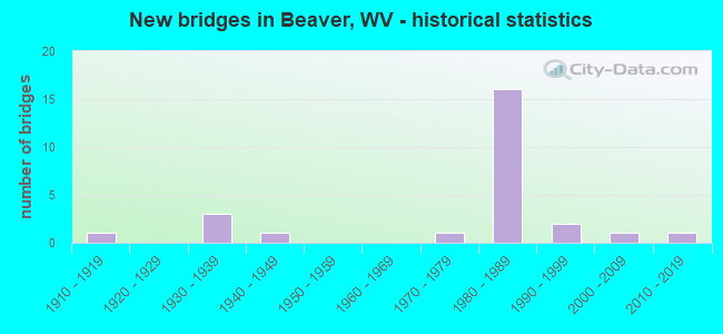
- New bridges - historical statistics
- 11910-1919
- 31930-1939
- 11940-1949
- 11970-1979
- 161980-1989
- 21990-1999
- 12000-2009
- 12010-2019
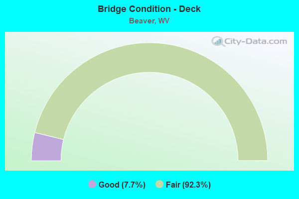
- Bridge Condition - Deck
- 7.7%Good
- 92.3%Fair
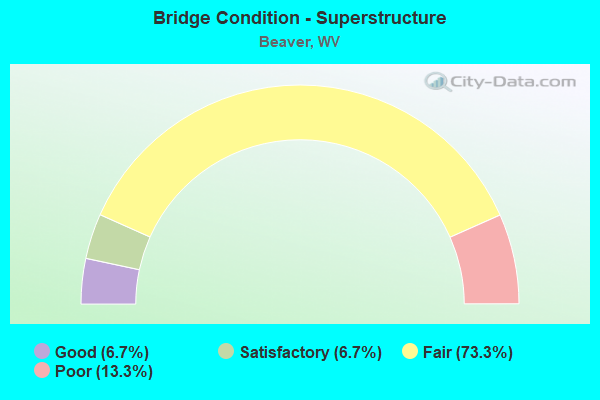
- Bridge Condition - Superstructure
- 6.7%Good
- 6.7%Satisfactory
- 73.3%Fair
- 13.3%Poor
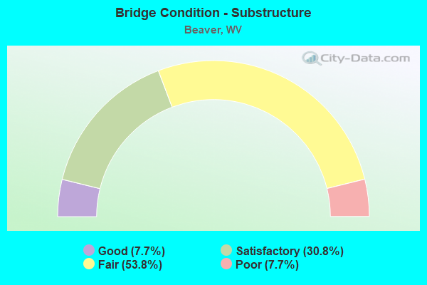
- Bridge Condition - Substructure
- 7.7%Good
- 30.8%Satisfactory
- 53.8%Fair
- 7.7%Poor
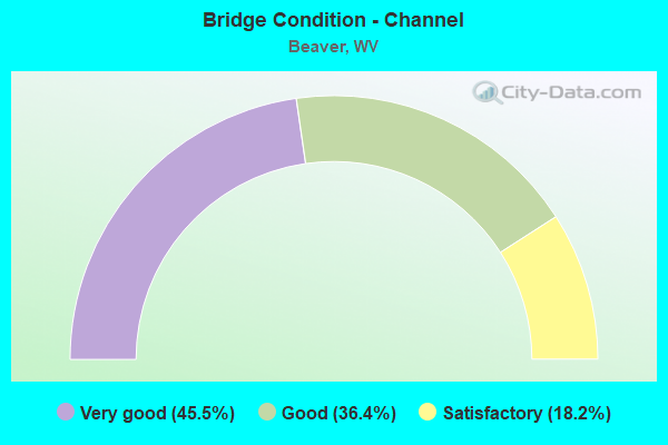
- Bridge Condition - Channel
- 45.5%Very good
- 36.4%Good
- 18.2%Satisfactory
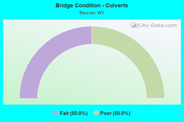
- Bridge Condition - Culverts
- 50.0%Fair
- 50.0%Poor
Find on map >> Show street view
Structure Number: 41A003, Location: 0.68 MI WEST OF US 19 (Lat: 37.752961, Lng: -81.152019), Route carried "on" structure: Interstate 6400, Year Built: 1985, Status: Open, Structure Length: 0.94m (3.08ft), Average Daily Traffic: 17,300 (year 2018), Truck Traffic: 27%, Average Future Daily Traffic: 21,798 (year 2038), Design Load: HS 20, Features Intersected: County Route 19/11, Facility Carried by Structure: I-64
Minimum Vertical Clearance: 30+ m (98+ ft), Kilometerpoint: 197.821, Lanes on structure: 4, Lanes under structure: 2, Base Highway Network: Yes, Owner: State Highway Agency, Approaching Roadway Width: 20.7m (67.9ft), Skew: 1 degrees, Material/Design: Concrete, Design/Construction: Culvert, Number Of Spans In Main Unit: 1, Length of Maximum Span: 8.3m (27.2ft)
Condition: Culverts: Fair, Operating Rating: 71.7 metric tons, Method Used To Determine Operating Rating: Field evaluation and documented engineering judgment, Inventory Rating: 32.7 metric tons, Method Used To Determine Inventory Rating: Field evaluation and documented engineering judgment, Structural Evaluation: Somewhat better than minimum adequacy, Underclear: High priority of corrective action, Approach Roadway Alignment: Equal to present desirable criteria, Length Of Structure Improvement: 0.94m (3.08ft), Designated Inspection Frequency: Every 24 months, Inspection Date: January 2021, Bridge Improvement Cost: $750,000, Roadway Improvement Cost: $50,000, Total Project Cost: $800,000 ( Estimate for 2021)
Find on map >> Show street view
Structure Number: 41A057, Location: 0.02 MI S OF US 19 (Lat: 37.749500, Lng: -81.140611), Route carried "on" structure: County highway 900, Year Built: 1940, Status: Posted for load, Structure Length: 1.42m (4.66ft), Average Daily Traffic: 300 (year 2019), Truck Traffic: 5%, Average Future Daily Traffic: 378 (year 2039), Features Intersected: BEAVER CR, Facility Carried by Structure: CR 9
Minimum Vertical Clearance: 30+ m (98+ ft), Kilometerpoint: 0.257, Lanes on structure: 1, Owner: State Highway Agency, Approaching Roadway Width: 6.1m (20.0ft), Skew: 2 degrees, Material/Design: Steel, Design/Construction: Stringer/Multi-beam, Number Of Spans In Main Unit: 1, Length of Maximum Span: 12.6m (41.3ft), Curb or Sidewalk Widths: Left: 0.2m (0.7ft), Right: 1.5m (4.9ft), Curb-To-Curb Width: 3.6m (11.8ft), Out-to-Out Width: 5.4m (17.7ft)
Condition: Deck: Fair, Superstructure: Fair, Substructure: Satisfactory, Channel: Good, Operating Rating: 40.8 metric tons, Method Used To Determine Operating Rating: Load Factor (LF), Inventory Rating: 24.5 metric tons, Method Used To Determine Inventory Rating: Load Factor (LF), Structural Evaluation: Somewhat better than minimum adequacy, Deck Geometry: High priority of replacement, Waterway Adequacy: Better than present minimum criteria, Approach Roadway Alignment: Better than present minimum criteria, Length Of Structure Improvement: 1.43m (4.69ft), Designated Inspection Frequency: Every 24 months, Inspection Date: May 2021, Bridge Improvement Cost: $500,000, Roadway Improvement Cost: $50,000, Total Project Cost: $550,000 ( Estimate for 2019), Deck Structure Type: Concrete Cast-file-Place
Find on map >> Show street view
Structure Number: 41A08, Location: 0.02 MI S OF C0 119/14 (Lat: 37.754139, Lng: -81.149261), Route carried "on" structure: US 1900, Year Built: 1930, Status: Open, Structure Length: 2.61m (8.56ft), Average Daily Traffic: 14,400 (year 2018), Truck Traffic: 7%, Average Future Daily Traffic: 18,144 (year 2038), Features Intersected: BEAVER CREEK, Facility Carried by Structure: US 19
Minimum Vertical Clearance: 30+ m (98+ ft), Kilometerpoint: 22.338, Lanes on structure: 2, Base Highway Network: Yes, Owner: State Highway Agency, Approaching Roadway Width: 8.5m (27.9ft), Skew: 3 degrees, Material/Design: Concrete, Design/Construction: Arch - Deck, Number Of Spans In Main Unit: 1, Length of Maximum Span: 24.4m (80.1ft), Curb or Sidewalk Widths: Left: 0.9m (3.0ft), Right: 0.9m (3.0ft), Curb-To-Curb Width: 8.5m (27.9ft), Out-to-Out Width: 11.1m (36.4ft)
Condition: Superstructure: Poor, Channel: Good, Operating Rating: 46.3 metric tons, Method Used To Determine Operating Rating: Field evaluation and documented engineering judgment, Inventory Rating: 20.0 metric tons, Method Used To Determine Inventory Rating: Field evaluation and documented engineering judgment, Structural Evaluation: Meets minimum limits, Deck Geometry: High priority of replacement, Waterway Adequacy: Equal to present minimum criteria, Approach Roadway Alignment: Better than present minimum criteria, Length Of Structure Improvement: 2.62m (8.60ft), Designated Inspection Frequency: Every 24 months, Inspection Date: January 2021, Bridge Improvement Cost: $1,500,000, Roadway Improvement Cost: $250,000, Total Project Cost: $1,750,000 ( Estimate for 2021)
Find on map >> Show street view
Structure Number: 41A09, Location: 0.55 MI W OF CR 19/13 (Lat: 37.737161, Lng: -81.136011), Route carried "on" structure: County highway 1912, Year Built: 1990, Status: Open, Structure Length: 1.57m (5.15ft), Average Daily Traffic: 2,000 (year 2018), Truck Traffic: 5%, Average Future Daily Traffic: 2,520 (year 2038), Design Load: HS 20, Features Intersected: BEAVER CREEK, Facility Carried by Structure: CR 19/12
Minimum Vertical Clearance: 30+ m (98+ ft), Kilometerpoint: 2.511, Lanes on structure: 2, Owner: State Highway Agency, Approaching Roadway Width: 5.5m (18.0ft), Skew: 1 degrees, Material/Design: Prestressed concrete, Design/Construction: Box Beam or Girders - Multiple, Number Of Spans In Main Unit: 1, Length of Maximum Span: 14.6m (47.9ft), Curb-To-Curb Width: 6.4m (21.0ft), Out-to-Out Width: 6.5m (21.3ft)
Condition: Deck: Fair, Superstructure: Fair, Substructure: Fair, Channel: Satisfactory, Operating Rating: 88.9 metric tons, Method Used To Determine Operating Rating: Load Factor (LF), Inventory Rating: 65.3 metric tons, Method Used To Determine Inventory Rating: Load Factor (LF), Structural Evaluation: Somewhat better than minimum adequacy, Deck Geometry: High priority of replacement, Waterway Adequacy: Better than present minimum criteria, Approach Roadway Alignment: Equal to present minimum criteria, Length Of Structure Improvement: 1.59m (5.22ft), Designated Inspection Frequency: Every 24 months, Inspection Date: October 2020, Bridge Improvement Cost: $350,000, Roadway Improvement Cost: $75,000, Total Project Cost: $425,000 ( Estimate for 2021), Deck Structure Type: Other, Wearing Surface/Protective System: Deck Protection: Epoxy Coated Reinforcing
Find on map >> Show street view
Structure Number: 41A095, Location: 0.02 MI N OF CR 19/12 (Lat: 37.747261, Lng: -81.138431), Route carried "on" structure: County highway 1927, Year Built: 1936, Year Reconstructed: 1989, Status: Open, Structure Length: 1.29m (4.23ft), Average Daily Traffic: 350 (year 2019), Truck Traffic: 5%, Average Future Daily Traffic: 441 (year 2039), Design Load: HS 20, Features Intersected: BEAVER CREEK, Facility Carried by Structure: CR 19/27
Minimum Vertical Clearance: 30+ m (98+ ft), Kilometerpoint: 0.032, Lanes on structure: 1, Owner: State Highway Agency, Approaching Roadway Width: 4.0m (13.1ft), Skew: 2 degrees, Material/Design: Steel, Design/Construction: Stringer/Multi-beam, Number Of Spans In Main Unit: 1, Length of Maximum Span: 11.9m (39.0ft), Curb or Sidewalk Widths: Left: 0.2m (0.7ft), Right: 0.2m (0.7ft), Curb-To-Curb Width: 4.0m (13.1ft), Out-to-Out Width: 4.4m (14.4ft)
Condition: Deck: Fair, Superstructure: Fair, Substructure: Fair, Channel: Very good, Operating Rating: 88.9 metric tons, Method Used To Determine Operating Rating: Load Factor (LF), Inventory Rating: 62.6 metric tons, Method Used To Determine Inventory Rating: Load Factor (LF), Structural Evaluation: Somewhat better than minimum adequacy, Deck Geometry: High priority of replacement, Waterway Adequacy: Equal to present desirable criteria, Approach Roadway Alignment: High priority of corrective action, Length Of Structure Improvement: 1.28m (4.20ft), Designated Inspection Frequency: Every 24 months, Inspection Date: May 2021, Bridge Improvement Cost: $450,000, Roadway Improvement Cost: $50,000, Total Project Cost: $500,000 ( Estimate for 2017), Deck Structure Type: Wood or Timber, Wearing Surface/Protective System: Wearing Surface: Bituminous
Find on map >> Show street view
Structure Number: 41A105, Location: 0.30 MI S OF CR 19/41 (Lat: 37.722500, Lng: -81.184669), Route carried "on" structure: County highway 2500, Year Built: 1986, Status: Open, Structure Length: 5.83m (19.13ft), Average Daily Traffic: 850 (year 2018), Truck Traffic: 5%, Average Future Daily Traffic: 1,071 (year 2038), Features Intersected: Interstate 77 SB, Facility Carried by Structure: CR 25
Minimum Vertical Clearance: 30+ m (98+ ft), Kilometerpoint: 5.053, Lanes on structure: 2, Lanes under structure: 3, Toll: On toll road, Owner: State Highway Agency, Approaching Roadway Width: 10.4m (34.1ft), Skew: 2 degrees, Material/Design: Steel continuous, Design/Construction: Stringer/Multi-beam, Number Of Spans In Main Unit: 1, Number Of Approach Spans: 2, Length of Maximum Span: 26.2m (86.0ft), Curb-To-Curb Width: 8.8m (28.9ft), Out-to-Out Width: 9.9m (32.5ft)
Condition: Deck: Fair, Superstructure: Fair, Substructure: Fair, Operating Rating: 77.1 metric tons, Method Used To Determine Operating Rating: Load Factor (LF), Inventory Rating: 46.3 metric tons, Method Used To Determine Inventory Rating: Load Factor (LF), Structural Evaluation: Somewhat better than minimum adequacy, Deck Geometry: Somewhat better than minimum adequacy, Underclear: Equal to present minimum criteria, Approach Roadway Alignment: Equal to present minimum criteria, Designated Inspection Frequency: Every 24 months, Inspection Date: Febuary 2021, Deck Structure Type: Concrete Cast-file-Place, Wearing Surface/Protective System: Wearing Surface: Monolithic Concrete, Deck Protection: Epoxy Coated Reinforcing
Find on map >> Show street view
Structure Number: 41A165, Location: 0.11 MI. E. OF CR 19/11 (Lat: 37.754481, Lng: -81.151189), Route carried "on" structure: Interstate 6400, Year Built: 1987, Status: Open, Structure Length: 23.40m (76.77ft), Average Daily Traffic: 8,650 (year 2018), Truck Traffic: 27%, Average Future Daily Traffic: 11,937 (year 2038), Design Load: HS 20+Mod, Features Intersected: Beaver Creek & US 19, Facility Carried by Structure: I-64
Minimum Vertical Clearance: 30+ m (98+ ft), Kilometerpoint: 197.998, Lanes on structure: 2, Lanes under structure: 2, Base Highway Network: Yes, Owner: State Highway Agency, Approaching Roadway Width: 10.4m (34.1ft), Material/Design: Steel continuous, Design/Construction: Stringer/Multi-beam, Number Of Spans In Main Unit: 2, Number Of Approach Spans: 4, Length of Maximum Span: 49.4m (162.1ft), Curb-To-Curb Width: 12.4m (40.7ft), Out-to-Out Width: 13.5m (44.3ft)
Condition: Deck: Fair, Superstructure: Fair, Substructure: Fair, Channel: Very good, Operating Rating: 71.7 metric tons, Method Used To Determine Operating Rating: Load Factor (LF), Inventory Rating: 42.6 metric tons, Method Used To Determine Inventory Rating: Load Factor (LF), Structural Evaluation: Somewhat better than minimum adequacy, Deck Geometry: Better than present minimum criteria, Underclear: Meets minimum limits, Waterway Adequacy: Superior to present desirable criteria, Approach Roadway Alignment: Superior to present desirable criteria, Designated Inspection Frequency: Every 24 months, Inspection Date: August 2020, Deck Structure Type: Concrete Cast-file-Place, Wearing Surface/Protective System: Wearing Surface: Integral Concrete, Deck Protection: Epoxy Coated Reinforcing
Find on map >> Show street view
Structure Number: 41A166, Location: 0.11 Mile East of 19/11 (Lat: 37.754589, Lng: -81.151539), Route carried "on" structure: Interstate 6400, Year Built: 1987, Status: Open, Structure Length: 23.40m (76.77ft), Average Daily Traffic: 8,650 (year 2018), Truck Traffic: 27%, Average Future Daily Traffic: 10,899 (year 2038), Design Load: HS 20+Mod, Features Intersected: Beaver CK. & U S 19, Facility Carried by Structure: I-64
Minimum Vertical Clearance: 30+ m (98+ ft), Kilometerpoint: 197.998, Lanes on structure: 2, Lanes under structure: 2, Base Highway Network: Yes, Owner: State Highway Agency, Approaching Roadway Width: 10.4m (34.1ft), Material/Design: Steel continuous, Design/Construction: Stringer/Multi-beam, Number Of Spans In Main Unit: 2, Number Of Approach Spans: 4, Length of Maximum Span: 49.4m (162.1ft), Curb-To-Curb Width: 12.4m (40.7ft), Out-to-Out Width: 13.5m (44.3ft)
Condition: Deck: Fair, Superstructure: Satisfactory, Substructure: Satisfactory, Channel: Very good, Operating Rating: 71.7 metric tons, Method Used To Determine Operating Rating: Load Factor (LF), Inventory Rating: 42.6 metric tons, Method Used To Determine Inventory Rating: Load Factor (LF), Structural Evaluation: Equal to present minimum criteria, Deck Geometry: Better than present minimum criteria, Underclear: Meets minimum limits, Waterway Adequacy: Superior to present desirable criteria, Approach Roadway Alignment: Superior to present desirable criteria, Designated Inspection Frequency: Every 24 months, Inspection Date: August 2020, Deck Structure Type: Concrete Cast-file-Place, Wearing Surface/Protective System: Wearing Surface: Integral Concrete, Deck Protection: Epoxy Coated Reinforcing
Find on map >> Show street view
Structure Number: 41A173, Location: 1.26 MILES E. OF US 19 (Lat: 37.766519, Lng: -81.124900), Route carried "on" structure: Interstate 6400, Year Built: 1986, Status: Open, Structure Length: 9.53m (31.27ft), Average Daily Traffic: 10,150 (year 2018), Truck Traffic: 27%, Average Future Daily Traffic: 12,789 (year 2038), Design Load: HS 20+Mod, Features Intersected: CR 9/9, Facility Carried by Structure: I-64 EB
Minimum Vertical Clearance: 30+ m (98+ ft), Kilometerpoint: 200.991, Lanes on structure: 4, Lanes under structure: 5, Base Highway Network: Yes, Owner: State Highway Agency, Approaching Roadway Width: 10.4m (34.1ft), Skew: 13 degrees, Material/Design: Steel continuous, Design/Construction: Stringer/Multi-beam, Number Of Spans In Main Unit: 1, Number Of Approach Spans: 2, Length of Maximum Span: 40.8m (133.9ft), Curb-To-Curb Width: 24.8m (81.4ft), Out-to-Out Width: 25.9m (85.0ft)
Condition: Deck: Fair, Superstructure: Poor, Substructure: Fair, Operating Rating: 61.7 metric tons, Method Used To Determine Operating Rating: Load Factor (LF), Inventory Rating: 37.2 metric tons, Method Used To Determine Inventory Rating: Load Factor (LF), Structural Evaluation: Meets minimum limits, Deck Geometry: Superior to present desirable criteria, Underclear: Meets minimum limits, Approach Roadway Alignment: Equal to present desirable criteria, Designated Inspection Frequency: Every 24 months, Inspection Date: July 2020, Deck Structure Type: Concrete Cast-file-Place, Wearing Surface/Protective System: Wearing Surface: Monolithic Concrete, Deck Protection: Epoxy Coated Reinforcing
Find on map >> Show street view
Structure Number: 41A174, Location: 1.26 MI. E. OF US. 19 (Lat: 37.767031, Lng: -81.124581), Route carried "on" structure: Interstate 6400, Year Built: 1986, Status: Open, Structure Length: 9.79m (32.12ft), Average Daily Traffic: 10,500 (year 2018), Truck Traffic: 27%, Average Future Daily Traffic: 12,789 (year 2038), Design Load: HS 20+Mod, Features Intersected: County Route 9/9, Facility Carried by Structure: I-64 WB
Minimum Vertical Clearance: 30+ m (98+ ft), Kilometerpoint: 200.991, Lanes on structure: 3, Lanes under structure: 5, Base Highway Network: Yes, Owner: State Highway Agency, Approaching Roadway Width: 10.4m (34.1ft), Skew: 14 degrees, Material/Design: Steel continuous, Design/Construction: Stringer/Multi-beam, Number Of Spans In Main Unit: 1, Number Of Approach Spans: 2, Length of Maximum Span: 41.1m (134.8ft), Curb-To-Curb Width: 14.9m (48.9ft), Out-to-Out Width: 15.9m (52.2ft)
Condition: Deck: Fair, Superstructure: Fair, Substructure: Fair, Operating Rating: 58.0 metric tons, Method Used To Determine Operating Rating: Load Factor (LF), Inventory Rating: 34.5 metric tons, Method Used To Determine Inventory Rating: Load Factor (LF), Structural Evaluation: Somewhat better than minimum adequacy, Deck Geometry: Meets minimum limits, Underclear: Somewhat better than minimum adequacy, Approach Roadway Alignment: Equal to present desirable criteria, Designated Inspection Frequency: Every 24 months, Inspection Date: July 2020, Deck Structure Type: Concrete Cast-file-Place, Wearing Surface/Protective System: Wearing Surface: Monolithic Concrete, Deck Protection: Epoxy Coated Reinforcing
Find on map >> Show street view
Structure Number: 41A175, Location: 0.85 MI S OF US 19 (Lat: 37.749739, Lng: -81.155650), Route carried "on" structure: County highway 2500, Year Built: 1985, Status: Open, Structure Length: 8.96m (29.40ft), Average Daily Traffic: 950 (year 2018), Truck Traffic: 5%, Average Future Daily Traffic: 1,197 (year 2038), Design Load: HS 20, Features Intersected: I 64, Facility Carried by Structure: CR 25
Minimum Vertical Clearance: 30+ m (98+ ft), Kilometerpoint: 9.495, Lanes on structure: 2, Lanes under structure: 4, Owner: State Highway Agency, Approaching Roadway Width: 7.3m (24.0ft), Skew: 1 degrees, Material/Design: Steel continuous, Design/Construction: Stringer/Multi-beam, Number Of Spans In Main Unit: 2, Length of Maximum Span: 44.2m (145.0ft), Curb-To-Curb Width: 14.3m (46.9ft), Out-to-Out Width: 15.3m (50.2ft)
Condition: Deck: Fair, Superstructure: Fair, Substructure: Poor, Operating Rating: 70.7 metric tons, Method Used To Determine Operating Rating: Load Factor (LF), Inventory Rating: 42.6 metric tons, Method Used To Determine Inventory Rating: Load Factor (LF), Structural Evaluation: Meets minimum limits, Deck Geometry: Superior to present desirable criteria, Underclear: Better than present minimum criteria, Approach Roadway Alignment: Equal to present minimum criteria, Designated Inspection Frequency: Every 24 months, Inspection Date: March 2021, Deck Structure Type: Concrete Cast-file-Place, Wearing Surface/Protective System: Wearing Surface: Monolithic Concrete, Deck Protection: Epoxy Coated Reinforcing
Find on map >> Show street view
Structure Number: 41A179, Location: 0.03 MI S OF CR 9 (Lat: 37.749850, Lng: -81.140111), Route carried "on" structure: US 1900, Year Built: 1915, Status: Posted for load, Structure Length: 1.38m (4.53ft), Average Daily Traffic: 14,400 (year 2018), Truck Traffic: 7%, Average Future Daily Traffic: 18,144 (year 2038), Features Intersected: LITTLE BEAVER CREEK, Facility Carried by Structure: US 19
Minimum Vertical Clearance: 30+ m (98+ ft), Kilometerpoint: 21.259, Lanes on structure: 2, Owner: State Highway Agency, Approaching Roadway Width: 9.1m (29.9ft), Material/Design: Concrete, Design/Construction: Arch - Deck, Number Of Spans In Main Unit: 1, Length of Maximum Span: 12.2m (40.0ft), Curb or Sidewalk Widths: Left: 1.5m (4.9ft), Right: 0.7m (2.3ft), Curb-To-Curb Width: 10.6m (34.8ft), Out-to-Out Width: 13.2m (43.3ft)
Condition: Superstructure: Fair, Channel: Good, Operating Rating: 31.7 metric tons, Method Used To Determine Operating Rating: Field evaluation and documented engineering judgment, Inventory Rating: 14.5 metric tons, Method Used To Determine Inventory Rating: Field evaluation and documented engineering judgment, Structural Evaluation: High priority of replacement, Deck Geometry: Meets minimum limits, Waterway Adequacy: Equal to present desirable criteria, Approach Roadway Alignment: Equal to present minimum criteria, Length Of Structure Improvement: 1.37m (4.49ft), Designated Inspection Frequency: Every 24 months, Inspection Date: December 2020, Bridge Improvement Cost: $1,000,000, Roadway Improvement Cost: $250,000, Total Project Cost: $1,250,000 ( Estimate for 2021)
Find on map >> Show street view
Structure Number: 41A187, Location: 0.19 MI S OF CO 19/41 (Lat: 37.723711, Lng: -81.183089), Route carried "on" structure: County highway 2500, Year Built: 1985, Status: Open, Structure Length: 10.49m (34.42ft), Average Daily Traffic: 850 (year 2019), Truck Traffic: 6%, Average Future Daily Traffic: 1,564 (year 2039), Design Load: HS 20, Features Intersected: I 77, Facility Carried by Structure: COUNTY ROUTE 25
Minimum Vertical Clearance: 30+ m (98+ ft), Kilometerpoint: 5.230, Lanes on structure: 2, Lanes under structure: 3, Owner: State Highway Agency, Approaching Roadway Width: 7.3m (24.0ft), Material/Design: Steel, Design/Construction: Frame, Number Of Spans In Main Unit: 1, Length of Maximum Span: 103.6m (339.9ft), Curb-To-Curb Width: 11.8m (38.7ft), Out-to-Out Width: 12.9m (42.3ft)
Condition: Deck: Fair, Superstructure: Fair, Substructure: Fair, Operating Rating: 48.1 metric tons, Method Used To Determine Operating Rating: Load Factor (LF), Inventory Rating: 29.0 metric tons, Method Used To Determine Inventory Rating: Load Factor (LF), Structural Evaluation: Somewhat better than minimum adequacy, Deck Geometry: Better than present minimum criteria, Underclear: Equal to present minimum criteria, Approach Roadway Alignment: Equal to present minimum criteria, Designated Inspection Frequency: Every 24 months, Critical Feature Inspection Frequency: Every 24 months, Inspection Date: November 2021, Critical Feature Inspection Date: November 2021, Deck Structure Type: Concrete Cast-file-Place, Wearing Surface/Protective System: Wearing Surface: Monolithic Concrete, Deck Protection: Epoxy Coated Reinforcing
Find on map >> Show street view
Structure Number: 41A19, Location: 0.20 MI W OF US 19 (Lat: 37.750969, Lng: -81.132969), Route carried "on" structure: State highway 30700, Year Built: 1970, Status: Open, Structure Length: 1.49m (4.89ft), Average Daily Traffic: 8,300 (year 2019), Truck Traffic: 5%, Average Future Daily Traffic: 10,458 (year 2039), Features Intersected: LITTLE BEAVER CREEK, Facility Carried by Structure: WV 307
Minimum Vertical Clearance: 30+ m (98+ ft), Kilometerpoint: 0.290, Lanes on structure: 2, Owner: State Highway Agency, Approaching Roadway Width: 8.5m (27.9ft), Material/Design: Steel, Design/Construction: Culvert, Number Of Spans In Main Unit: 1, Number Of Approach Spans: 1, Length of Maximum Span: 5.9m (19.4ft)
Condition: Channel: Satisfactory, Culverts: Poor, Operating Rating: 53.5 metric tons, Method Used To Determine Operating Rating: Field evaluation and documented engineering judgment, Inventory Rating: 24.5 metric tons, Method Used To Determine Inventory Rating: Field evaluation and documented engineering judgment, Structural Evaluation: Meets minimum limits, Waterway Adequacy: Equal to present minimum criteria, Approach Roadway Alignment: Equal to present desirable criteria, Length Of Structure Improvement: 1.49m (4.89ft), Designated Inspection Frequency: Every 24 months, Other Special Inspection Frequency: Every 12 months, Inspection Date: April 2021, Other Special Inspection Date: April 2021, Bridge Improvement Cost: $500,000, Roadway Improvement Cost: $50,000, Total Project Cost: $550,000 ( Estimate for 2019)
Find on map >> Show street view
Structure Number: 41A267, Location: 0.09 MI. EAST OF US 19 (Lat: 37.750539, Lng: -81.147500), Route carried "on" structure: County highway 1912, Year Built: 1998, Status: Open, Structure Length: 1.82m (5.97ft), Average Daily Traffic: 2,000 (year 2019), Truck Traffic: 5%, Average Future Daily Traffic: 2,520 (year 2039), Design Load: HS 25 or greater, Features Intersected: BEAVER CREEEK, Facility Carried by Structure: CO 19/12
Minimum Vertical Clearance: 30+ m (98+ ft), Kilometerpoint: 0.145, Lanes on structure: 2, Owner: State Highway Agency, Approaching Roadway Width: 6.1m (20.0ft), Skew: 2 degrees, Material/Design: Prestressed concrete, Design/Construction: Box Beam or Girders - Multiple, Number Of Spans In Main Unit: 1, Length of Maximum Span: 17.1m (56.1ft), Curb-To-Curb Width: 7.4m (24.3ft), Out-to-Out Width: 7.4m (24.3ft)
Condition: Deck: Fair, Superstructure: Fair, Substructure: Satisfactory, Channel: Very good, Operating Rating: 80.7 metric tons, Method Used To Determine Operating Rating: Load Factor (LF), Inventory Rating: 48.1 metric tons, Method Used To Determine Inventory Rating: Load Factor (LF), Structural Evaluation: Somewhat better than minimum adequacy, Deck Geometry: Meets minimum limits, Waterway Adequacy: Better than present minimum criteria, Approach Roadway Alignment: Better than present minimum criteria, Designated Inspection Frequency: Every 24 months, Inspection Date: May 2021, Deck Structure Type: Other, Wearing Surface/Protective System: Deck Protection: Epoxy Coated Reinforcing
Find on map >> Show street view
Structure Number: 41A285, Location: 0.05 MILE N OF US 19 (Lat: 37.750361, Lng: -81.138839), Route carried "on" structure: County highway 11930, Year Built: 2002, Status: Open, Structure Length: 1.46m (4.79ft), Average Daily Traffic: 10 (year 2018), Truck Traffic: 5%, Average Future Daily Traffic: 13 (year 2038), Design Load: HS 25 or greater, Features Intersected: LITTLE BEAVER CREEK, Facility Carried by Structure: COUNTY RT 119/30
Minimum Vertical Clearance: 30+ m (98+ ft), Kilometerpoint: 0.080, Lanes on structure: 1, Owner: State Highway Agency, Approaching Roadway Width: 3.0m (9.8ft), Skew: 3 degrees, Material/Design: Prestressed concrete, Design/Construction: Box Beam or Girders - Multiple, Number Of Spans In Main Unit: 1, Length of Maximum Span: 13.4m (44.0ft), Curb-To-Curb Width: 4.6m (15.1ft), Out-to-Out Width: 4.7m (15.4ft)
Condition: Deck: Fair, Superstructure: Fair, Substructure: Satisfactory, Channel: Good, Operating Rating: 79.8 metric tons, Method Used To Determine Operating Rating: Load Factor (LF), Inventory Rating: 48.1 metric tons, Method Used To Determine Inventory Rating: Load Factor (LF), Structural Evaluation: Somewhat better than minimum adequacy, Deck Geometry: Better than present minimum criteria, Waterway Adequacy: Equal to present desirable criteria, Approach Roadway Alignment: Equal to present desirable criteria, Designated Inspection Frequency: Every 24 months, Inspection Date: December 2020, Deck Structure Type: Other, Wearing Surface/Protective System: Deck Protection: Epoxy Coated Reinforcing
Find on map >> Show street view
Structure Number: 41A311, Location: 0.18 MI. West Of CR 19/13 (Lat: 37.722661, Lng: -81.145461), Route carried "on" structure: County highway 11944, Year Built: 2011, Status: Open, Structure Length: 1.51m (4.95ft), Average Daily Traffic: 104 (year 2016), Truck Traffic: 5%, Average Future Daily Traffic: 131 (year 2036), Design Load: HL 93, Features Intersected: Beaver Creek, Facility Carried by Structure: County RT 119/44
Minimum Vertical Clearance: 30+ m (98+ ft), Kilometerpoint: 0.290, Lanes on structure: 2, Owner: State Highway Agency, Approaching Roadway Width: 4.9m (16.1ft), Material/Design: Prestressed concrete, Design/Construction: Box Beam or Girders - Multiple, Number Of Spans In Main Unit: 1, Length of Maximum Span: 14.0m (45.9ft), Curb-To-Curb Width: 6.5m (21.3ft), Out-to-Out Width: 6.5m (21.3ft)
Condition: Deck: Good, Superstructure: Good, Substructure: Good, Channel: Very good, Operating Rating: 62.6 metric tons, Method Used To Determine Operating Rating: Load and Resistance Factor (LRFR), Inventory Rating: 48.1 metric tons, Method Used To Determine Inventory Rating: Load and Resistance Factor (LRFR), Structural Evaluation: Better than present minimum criteria, Deck Geometry: Meets minimum limits, Waterway Adequacy: Equal to present minimum criteria, Approach Roadway Alignment: Equal to present minimum criteria, Designated Inspection Frequency: Every 48 months, Inspection Date: January 2018, Deck Structure Type: Other, Wearing Surface/Protective System: Deck Protection: Epoxy Coated Reinforcing
Find on map >> Show street view
Structure Number: 41A081, Location: 0.01 MI S OF CR 19/42 (Lat: 37.756681, Lng: -81.156289), Route carried "under" structure: US 1900, Year Built: 1930, Structure Length: 0. m, Average Daily Traffic: 15,100 (year 2018), Truck Traffic: 7%, Features Intersected: US 19, Facility Carried by Structure: CSX RAILROAD
Minimum Vertical Clearance: 4.67m (15.32ft), Kilometerpoint: 23.062, Lanes under structure: 2, Material/Design: Steel, Design/Construction: Girder and Floorbeam System, Length of Maximum Span: 13.7m (44.9ft)
Find on map >> Show street view
Structure Number: 41A099, Location: 0.10MI. E. OF CR.19/13 (Lat: 37.713250, Lng: -81.151989), Route carried "under" structure: Interstate 7700, Year Built: 1984, Structure Length: 0. m, Average Daily Traffic: 26,000 (year 0010), Truck Traffic: 16%, Features Intersected: I 77, Facility Carried by Structure: CR. 19/41
Minimum Vertical Clearance: 5.05m (16.57ft), Kilometerpoint: 54.605, Lanes on structure: 2, Lanes under structure: 2, Toll: On toll road, Length of Maximum Span: 34.7m (113.8ft)
Find on map >> Show street view
Structure Number: 41A105, Location: 0.30 MI S OF CR 19/41 (Lat: 37.722500, Lng: -81.184669), Route carried "under" structure: Interstate 7700, Year Built: 1986, Structure Length: 0. m, Average Daily Traffic: 13,250 (year 0006), Truck Traffic: 25%, Features Intersected: Interstate 77 SB, Facility Carried by Structure: CR 25
Minimum Vertical Clearance: 12.78m (41.93ft), Kilometerpoint: 62.475, Lanes on structure: 2, Lanes under structure: 3, Toll: On toll road, Length of Maximum Span: 26.2m (86.0ft)
Find on map >> Show street view
Structure Number: 41A165, Location: 0.11 MI. E. OF CR 19/11 (Lat: 37.754481, Lng: -81.151189), Route carried "under" structure: US 1900, Year Built: 1987, Structure Length: 0. m, Average Daily Traffic: 13,000 (year 0012), Truck Traffic: 8%, Features Intersected: Beaver Creek & US 19, Facility Carried by Structure: I-64
Minimum Vertical Clearance: 30+ m (98+ ft), Kilometerpoint: 22.563, Lanes on structure: 2, Lanes under structure: 2, Length of Maximum Span: 49.4m (162.1ft)
Find on map >> Show street view
Structure Number: 41A166, Location: 0.11 Mile East of 19/11 (Lat: 37.754561, Lng: -81.151439), Route carried "under" structure: US 1900, Year Built: 1987, Structure Length: 0. m, Average Daily Traffic: 13,000 (year 0009), Truck Traffic: 8%, Features Intersected: Beaver CK. & U S 19, Facility Carried by Structure: I-64
Minimum Vertical Clearance: 30+ m (98+ ft), Kilometerpoint: 22.563, Lanes on structure: 2, Lanes under structure: 2, Length of Maximum Span: 49.4m (162.1ft)
Find on map >> Show street view
Structure Number: 41A173, Location: 1.26 MILES E. OF US 19 (Lat: 37.766519, Lng: -81.124889), Route carried "under" structure: County highway 909, Year Built: 1986, Structure Length: 0. m, Average Daily Traffic: 8,800 (year 0009), Truck Traffic: 6%, Features Intersected: CR 9/9, Facility Carried by Structure: I-64 EB
Minimum Vertical Clearance: 6.78m (22.24ft), Kilometerpoint: 0.306, Lanes on structure: 4, Lanes under structure: 5, Length of Maximum Span: 40.8m (133.9ft)
Find on map >> Show street view
Structure Number: 41A174, Location: 1.26 MI. E. OF US. 19 (Lat: 37.766850, Lng: -81.124639), Route carried "under" structure: County highway 99, Year Built: 1986, Structure Length: 0. m, Average Daily Traffic: 8,800 (year 0009), Truck Traffic: 6%, Features Intersected: County Route 9/9, Facility Carried by Structure: I-64 WB
Minimum Vertical Clearance: 6.20m (20.34ft), Kilometerpoint: 0.306, Lanes on structure: 3, Lanes under structure: 5, Length of Maximum Span: 41.1m (134.8ft)
Find on map >> Show street view
Structure Number: 41A175, Location: 0.85 MI S OF US 19 (Lat: 37.750131, Lng: -81.155919), Route carried "under" structure: Interstate 6400, Year Built: 1985, Structure Length: 0. m, Average Daily Traffic: 16,000 (year 0009), Truck Traffic: 17%, Features Intersected: I 64, Facility Carried by Structure: CR 25
Minimum Vertical Clearance: 8.76m (28.74ft), Kilometerpoint: 197.338, Lanes on structure: 2, Lanes under structure: 4, Length of Maximum Span: 44.2m (145.0ft)
Find on map >> Show street view
Structure Number: 41A187, Location: 0.19 MI S OF CO 19/41 (Lat: 37.723739, Lng: -81.183111), Route carried "under" structure: Interstate 7700, Year Built: 1985, Structure Length: 0. m, Average Daily Traffic: 14,000 (year 0010), Truck Traffic: 17%, Features Intersected: I 77, Facility Carried by Structure: COUNTY ROUTE 25
Minimum Vertical Clearance: 28.86m (94.69ft), Kilometerpoint: 62.475, Lanes on structure: 2, Lanes under structure: 3, Length of Maximum Span: 103.6m (339.9ft)