Bridge Statistics for Becket, Massachusetts (MA)
Condition, Traffic, Stress, Structural Evaluation, Project Costs
- National Bridge Inventory (NBI) Statistics
- 35Number of bridges
- 236ft / 71.7mTotal length
- $39,782,000Total costs
- 190,085Total average daily traffic
- 25,715Total average daily truck traffic
- National Bridge Inventory (NBI) Registered Bridges for Becket
- No street view available for this location
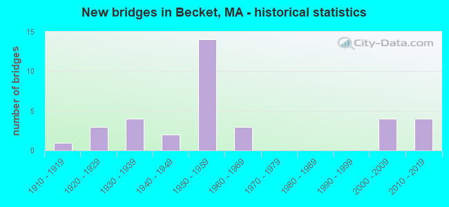
- New bridges - historical statistics
- 11910-1919
- 31920-1929
- 41930-1939
- 21940-1949
- 141950-1959
- 31960-1969
- 42000-2009
- 42010-2019

- Reconstructed bridges - Historical Statistics
- 11920-1929
- 01930-1939
- 01940-1949
- 01950-1959
- 01960-1969
- 11970-1979
- 51980-1989
- 31990-1999


- Bridge Condition - Deck
- 13.0%Very good
- 52.2%Good
- 26.1%Satisfactory
- 8.7%Fair

- Bridge Condition - Superstructure
- 8.3%Very good
- 37.5%Good
- 37.5%Satisfactory
- 16.7%Fair

- Bridge Condition - Substructure
- 16.7%Very good
- 41.7%Good
- 29.2%Satisfactory
- 8.3%Fair
- 4.2%Poor

- Bridge Condition - Channel
- 30.0%Very good
- 30.0%Good
- 15.0%Satisfactory
- 25.0%Fair

- Bridge Condition - Culverts
- 50.0%Very good
- 50.0%Satisfactory
Find on map >> Show street view
Structure Number: B03008BCLDOTNBI, Location: AT MILE MARKER 33.1 (Lat: 42.268114, Lng: -73.011267), Route carried "on" structure: US 20, Year Built: 2013, Status: Open, Structure Length: 2.36m (7.74ft), Average Daily Traffic: 1,552 (year 2018), Truck Traffic: 30%, Design Load: HL 93, Features Intersected: WATER WALKER BROOK
Minimum Vertical Clearance: 30+ m (98+ ft), Kilometerpoint: 53.355, Lanes on structure: 2, Owner: State Highway Agency, Approaching Roadway Width: 13.4m (44.0ft), Skew: 4 degrees, Material/Design: Steel, Design/Construction: Stringer/Multi-beam, Number Of Spans In Main Unit: 1, Length of Maximum Span: 22.9m (75.1ft), Curb-To-Curb Width: 13.4m (44.0ft), Out-to-Out Width: 14.4m (47.2ft)
Condition: Deck: Very good, Superstructure: Very good, Substructure: Very good, Channel: Satisfactory, Operating Rating: 48.6 metric tons, Method Used To Determine Operating Rating: Load and Resistance Factor Rating (LRFR) rating reported by rating factor(RF) method using HL-93 loadings, Inventory Rating: 38.9 metric tons, Method Used To Determine Inventory Rating: Load and Resistance Factor Rating (LRFR) rating reported by rating factor(RF) method using HL-93 loadings, Structural Evaluation: Equal to present desirable criteria, Deck Geometry: Equal to present desirable criteria, Waterway Adequacy: Equal to present desirable criteria, Approach Roadway Alignment: Equal to present desirable criteria, Designated Inspection Frequency: Every 24 months, Inspection Date: Febuary 2021, Deck Structure Type: Concrete Cast-file-Place, Wearing Surface/Protective System: Wearing Surface: Bituminous, Membrane: Preformed Fabric, Deck Protection: Epoxy Coated Reinforcing
Find on map >> Show street view
Structure Number: B03011BCNDOTNBI, Location: AT MILE MARKER 32.0 (Lat: 42.268150, Lng: -73.031136), Route carried "on" structure: US 20, Year Built: 2013, Status: Open, Structure Length: 2.86m (9.38ft), Average Daily Traffic: 1,552 (year 2018), Truck Traffic: 30%, Design Load: HL 93, Features Intersected: WATER WALKER BROOK
Minimum Vertical Clearance: 30+ m (98+ ft), Kilometerpoint: 51.562, Lanes on structure: 2, Owner: State Highway Agency, Approaching Roadway Width: 13.7m (44.9ft), Skew: 5 degrees, Material/Design: Steel, Design/Construction: Stringer/Multi-beam, Number Of Spans In Main Unit: 1, Length of Maximum Span: 27.4m (89.9ft), Curb-To-Curb Width: 13.4m (44.0ft), Out-to-Out Width: 14.4m (47.2ft)
Condition: Deck: Very good, Superstructure: Very good, Substructure: Very good, Channel: Very good, Operating Rating: 58.3 metric tons, Method Used To Determine Operating Rating: Load and Resistance Factor Rating (LRFR) rating reported by rating factor(RF) method using HL-93 loadings, Inventory Rating: 45.4 metric tons, Method Used To Determine Inventory Rating: Load and Resistance Factor Rating (LRFR) rating reported by rating factor(RF) method using HL-93 loadings, Structural Evaluation: Equal to present desirable criteria, Deck Geometry: Equal to present desirable criteria, Waterway Adequacy: Equal to present desirable criteria, Approach Roadway Alignment: Equal to present desirable criteria, Designated Inspection Frequency: Every 24 months, Inspection Date: Febuary 2021, Deck Structure Type: Concrete Cast-file-Place, Wearing Surface/Protective System: Wearing Surface: Bituminous, Membrane: Preformed Fabric, Deck Protection: Epoxy Coated Reinforcing
Find on map >> Show street view
Structure Number: B03016B78MUNNBI, Location: 300'N OF BOOKER HILL ROAD (Lat: 42.334711, Lng: -73.103272), Route carried "on" structure: City street , Year Built: 2009, Status: Open, Structure Length: 0.81m (2.66ft), Average Daily Traffic: 1,552 (year 2019), Truck Traffic: 6%, Average Future Daily Traffic: 1,579 (year 2032), Design Load: HS 25 or greater, Features Intersected: WATER SHAKER MILL BROOK, Facility Carried by Structure: HWY MCNERNEY RD
Minimum Vertical Clearance: 30+ m (98+ ft), Kilometerpoint: 0.000, Lanes on structure: 2, Owner: Town or Township Highway Agency, Approaching Roadway Width: 7.3m (24.0ft), Material/Design: Concrete, Design/Construction: Frame, Number Of Spans In Main Unit: 1, Length of Maximum Span: 7.3m (24.0ft), Curb-To-Curb Width: 7.3m (24.0ft), Out-to-Out Width: 8.2m (26.9ft)
Condition: Deck: Good, Superstructure: Good, Substructure: Good, Channel: Fair, Operating Rating: 85.1 metric tons, Method Used To Determine Operating Rating: Load Factor (LF), Inventory Rating: 50.9 metric tons, Method Used To Determine Inventory Rating: Load Factor (LF), Structural Evaluation: Better than present minimum criteria, Deck Geometry: Meets minimum limits, Waterway Adequacy: Superior to present desirable criteria, Approach Roadway Alignment: Equal to present desirable criteria, Length Of Structure Improvement: 0.90m (2.95ft), Designated Inspection Frequency: Every 24 months, Inspection Date: November 2021, Bridge Improvement Cost: $518,000, Roadway Improvement Cost: $52,000, Total Project Cost: $778,000 ( Estimate for 2022), Deck Structure Type: Concrete Precast Panels, Wearing Surface/Protective System: Wearing Surface: Bituminous, Membrane: Preformed Fabric, Deck Protection: Epoxy Coated Reinforcing
Find on map >> Show street view
Structure Number: B030190BADOTNBI, Location: 100' S. OF MCNERNEY ROAD (Lat: 42.314461, Lng: -73.093969), Route carried "on" structure: State highway 8, Year Built: 1915, Year Reconstructed: 1928, Status: Posted for load, Structure Length: 0.67m (2.20ft), Average Daily Traffic: 2,027 (year 2018), Truck Traffic: 10%, Average Future Daily Traffic: 3,632 (year 2032), Features Intersected: WATER YOKUM POND BROOK
Minimum Vertical Clearance: 30+ m (98+ ft), Kilometerpoint: 46.522, Lanes on structure: 2, Base Highway Network: Yes, Owner: State Highway Agency, Approaching Roadway Width: 10.1m (33.1ft), Skew: 1 degrees, Material/Design: Concrete, Design/Construction: Tee Beam, Number Of Spans In Main Unit: 1, Length of Maximum Span: 6.1m (20.0ft), Curb-To-Curb Width: 13.4m (44.0ft), Out-to-Out Width: 14.6m (47.9ft)
Condition: Deck: Good, Superstructure: Satisfactory, Substructure: Good, Channel: Good, Operating Rating: 33.6 metric tons, Method Used To Determine Operating Rating: Load Factor (LF), Inventory Rating: 20.1 metric tons, Method Used To Determine Inventory Rating: Load Factor (LF), Structural Evaluation: Somewhat better than minimum adequacy, Deck Geometry: Better than present minimum criteria, Waterway Adequacy: Equal to present desirable criteria, Approach Roadway Alignment: Meets minimum limits, Length Of Structure Improvement: 0.70m (2.30ft), Designated Inspection Frequency: Every 24 months, Inspection Date: June 2020, Bridge Improvement Cost: $402,000, Roadway Improvement Cost: $41,000, Total Project Cost: $604,000 ( Estimate for 2022), Deck Structure Type: Concrete Cast-file-Place, Wearing Surface/Protective System: Wearing Surface: Bituminous
Find on map >> Show street view
Structure Number: B030238VGDOTNBI, Location: @ CARTER RD. INTERSECTION (Lat: 42.325186, Lng: -73.083992), Route carried "on" structure: State highway 8, Year Built: 2006, Status: Open, Structure Length: 1.46m (4.79ft), Average Daily Traffic: 2,180 (year 2018), Truck Traffic: 12%, Average Future Daily Traffic: 3,632 (year 2031), Design Load: HS 25 or greater, Features Intersected: WATER YOKUM POND BROOK
Minimum Vertical Clearance: 30+ m (98+ ft), Kilometerpoint: 46.713, Lanes on structure: 2, Owner: State Highway Agency, Approaching Roadway Width: 10.0m (32.8ft), Skew: 4 degrees, Material/Design: Prestressed concrete, Design/Construction: Box Beam or Girders - Single/Spread, Number Of Spans In Main Unit: 1, Length of Maximum Span: 13.3m (43.6ft), Curb or Sidewalk Widths: Left: 1.5m (4.9ft), Right: 0.0m, Curb-To-Curb Width: 10.0m (32.8ft), Out-to-Out Width: 12.4m (40.7ft)
Condition: Deck: Good, Superstructure: Satisfactory, Substructure: Good, Channel: Fair, Operating Rating: 69.7 metric tons, Method Used To Determine Operating Rating: Load Factor (LF), Inventory Rating: 65.8 metric tons, Method Used To Determine Inventory Rating: Load Factor (LF), Structural Evaluation: Equal to present minimum criteria, Deck Geometry: Meets minimum limits, Waterway Adequacy: Superior to present desirable criteria, Approach Roadway Alignment: Equal to present desirable criteria, Length Of Structure Improvement: 1.50m (4.92ft), Designated Inspection Frequency: Every 24 months, Inspection Date: January 2022, Bridge Improvement Cost: $481,000, Roadway Improvement Cost: $49,000, Total Project Cost: $722,000 ( Estimate for 2022), Deck Structure Type: Concrete Cast-file-Place, Wearing Surface/Protective System: Wearing Surface: Bituminous, Membrane: Preformed Fabric, Deck Protection: Epoxy Coated Reinforcing
Find on map >> Show street view
Structure Number: B030240BCDOTNBI, Location: .2 MI SOUTH OF HIGH ST (Lat: 42.329353, Lng: -73.083747), Route carried "on" structure: State highway 8, Year Built: 1922, Status: Open, Structure Length: 0.90m (2.95ft), Average Daily Traffic: 1,700 (year 2014), Truck Traffic: 9%, Average Future Daily Traffic: 3,632 (year 2032), Design Load: H 15, Features Intersected: WATER YOKUM BROOK
Minimum Vertical Clearance: 30+ m (98+ ft), Kilometerpoint: 46.831, Lanes on structure: 2, Base Highway Network: Yes, Owner: State Highway Agency, Approaching Roadway Width: 8.0m (26.2ft), Skew: 4 degrees, Material/Design: Concrete, Design/Construction: Tee Beam, Number Of Spans In Main Unit: 1, Length of Maximum Span: 7.9m (25.9ft), Curb or Sidewalk Widths: Left: 0.2m (0.7ft), Right: 1.5m (4.9ft), Curb-To-Curb Width: 7.9m (25.9ft), Out-to-Out Width: 10.7m (35.1ft)
Condition: Deck: Good, Superstructure: Good, Substructure: Satisfactory, Channel: Good, Operating Rating: 41.3 metric tons, Method Used To Determine Operating Rating: Allowable Stress (AS), Inventory Rating: 28.0 metric tons, Method Used To Determine Inventory Rating: Allowable Stress (AS), Structural Evaluation: Equal to present minimum criteria, Deck Geometry: Meets minimum limits, Waterway Adequacy: Equal to present desirable criteria, Approach Roadway Alignment: Equal to present minimum criteria, Length Of Structure Improvement: 1.00m (3.28ft), Designated Inspection Frequency: Every 24 months, Inspection Date: November 2021, Bridge Improvement Cost: $421,000, Roadway Improvement Cost: $43,000, Total Project Cost: $632,000 ( Estimate for 2022), Deck Structure Type: Concrete Cast-file-Place, Wearing Surface/Protective System: Wearing Surface: Bituminous
Find on map >> Show street view
Structure Number: B030250BDDOTNBI, Location: 6.5 MI N OF US 20 (Lat: 42.332389, Lng: -73.085469), Route carried "on" structure: State highway 8, Year Built: 1922, Status: Posted for load, Structure Length: 0.85m (2.79ft), Average Daily Traffic: 1,739 (year 2015), Truck Traffic: 10%, Average Future Daily Traffic: 4,106 (year 2031), Design Load: H 15, Features Intersected: WATER SHAKER MILL BROOK
Minimum Vertical Clearance: 30+ m (98+ ft), Kilometerpoint: 47.233, Lanes on structure: 2, Base Highway Network: Yes, Owner: State Highway Agency, Approaching Roadway Width: 7.9m (25.9ft), Skew: 1 degrees, Material/Design: Concrete, Design/Construction: Tee Beam, Number Of Spans In Main Unit: 1, Length of Maximum Span: 7.6m (24.9ft), Curb or Sidewalk Widths: Left: 1.5m (4.9ft), Right: 0.2m (0.7ft), Curb-To-Curb Width: 7.9m (25.9ft), Out-to-Out Width: 10.5m (34.4ft)
Condition: Deck: Fair, Superstructure: Fair, Substructure: Fair, Channel: Fair, Operating Rating: 32.3 metric tons, Method Used To Determine Operating Rating: Load Factor (LF), Inventory Rating: 23.4 metric tons, Method Used To Determine Inventory Rating: Load Factor (LF), Structural Evaluation: Somewhat better than minimum adequacy, Deck Geometry: Meets minimum limits, Waterway Adequacy: Superior to present desirable criteria, Approach Roadway Alignment: Equal to present minimum criteria, Bridge Posting: Required (Relationship of Operating Rating to Maximum Legal Load: 0.1 - 9.9% below), Length Of Structure Improvement: 0.90m (2.95ft), Designated Inspection Frequency: Every 24 months, Inspection Date: June 2020, Bridge Improvement Cost: $372,000, Roadway Improvement Cost: $38,000, Total Project Cost: $559,000 ( Estimate for 2022), Deck Structure Type: Concrete Cast-file-Place, Wearing Surface/Protective System: Wearing Surface: Bituminous
Find on map >> Show street view
Structure Number: B030367N9MUNNBI, Location: @ MUNN RD INTERSECTION (Lat: 42.309492, Lng: -73.031503), Route carried "on" structure: City street , Year Built: 2006, Status: Open, Structure Length: 3.66m (12.01ft), Average Daily Traffic: 259 (year 2018), Truck Traffic: 6%, Average Future Daily Traffic: 158 (year 2031), Design Load: HS 25 or greater, Features Intersected: WATER W BR WESTFIELD R, Facility Carried by Structure: HWY BANCROFT RD
Minimum Vertical Clearance: 30+ m (98+ ft), Kilometerpoint: 0.000, Lanes on structure: 2, Owner: Town or Township Highway Agency, Approaching Roadway Width: 8.0m (26.2ft), Skew: 3 degrees, Material/Design: Prestressed concrete, Design/Construction: Stringer/Multi-beam, Number Of Spans In Main Unit: 1, Length of Maximum Span: 35.0m (114.8ft), Curb-To-Curb Width: 8.0m (26.2ft), Out-to-Out Width: 9.0m (29.5ft)
Condition: Deck: Very good, Superstructure: Good, Substructure: Very good, Channel: Very good, Operating Rating: 62.0 metric tons, Method Used To Determine Operating Rating: Load Factor (LF), Inventory Rating: 48.7 metric tons, Method Used To Determine Inventory Rating: Load Factor (LF), Structural Evaluation: Better than present minimum criteria, Deck Geometry: Somewhat better than minimum adequacy, Waterway Adequacy: Superior to present desirable criteria, Approach Roadway Alignment: Equal to present desirable criteria, Length Of Structure Improvement: 3.70m (12.14ft), Designated Inspection Frequency: Every 24 months, Inspection Date: September 2020, Bridge Improvement Cost: $1,047,000, Roadway Improvement Cost: $105,000, Total Project Cost: $1,571,000 ( Estimate for 2022), Deck Structure Type: Concrete Cast-file-Place, Wearing Surface/Protective System: Wearing Surface: Bituminous, Membrane: Preformed Fabric, Deck Protection: Epoxy Coated Reinforcing
Find on map >> Show street view
Structure Number: B03037BCPDOTNBI, Location: AT MILE MARKER 33 (Lat: 42.268186, Lng: -73.012364), Route carried "on" structure: US 20, Year Built: 2013, Status: Open, Structure Length: 1.10m (3.61ft), Average Daily Traffic: 1,552 (year 2018), Truck Traffic: 30%, Design Load: HL 93, Features Intersected: WATER CUSHMAN BROOK
Minimum Vertical Clearance: 30+ m (98+ ft), Kilometerpoint: 53.236, Lanes on structure: 2, Owner: State Highway Agency, Approaching Roadway Width: 12.2m (40.0ft), Material/Design: Concrete, Design/Construction: Frame, Number Of Spans In Main Unit: 1, Length of Maximum Span: 11.0m (36.1ft), Curb-To-Curb Width: 13.4m (44.0ft), Out-to-Out Width: 14.3m (46.9ft)
Condition: Superstructure: Good, Substructure: Very good, Channel: Very good, Operating Rating: 84.2 metric tons, Method Used To Determine Operating Rating: Load and Resistance Factor Rating (LRFR) rating reported by rating factor(RF) method using HL-93 loadings, Inventory Rating: 64.8 metric tons, Method Used To Determine Inventory Rating: Load and Resistance Factor Rating (LRFR) rating reported by rating factor(RF) method using HL-93 loadings, Structural Evaluation: Better than present minimum criteria, Deck Geometry: Equal to present desirable criteria, Waterway Adequacy: Superior to present desirable criteria, Approach Roadway Alignment: Equal to present desirable criteria, Designated Inspection Frequency: Every 24 months, Inspection Date: Febuary 2021
Find on map >> Show street view
Structure Number: B03039038MUNNBI, Location: @ INTER. WITH MAIN ST (Lat: 42.332100, Lng: -73.083164), Route carried "on" structure: City street , Year Built: 1928, Year Reconstructed: 1983, Status: Posted for load, Structure Length: 1.43m (4.69ft), Average Daily Traffic: 129 (year 2018), Truck Traffic: 6%, Average Future Daily Traffic: 158 (year 2033), Features Intersected: WATER YOKUM BROOK, Facility Carried by Structure: HWY MAPLE ST
Minimum Vertical Clearance: 30+ m (98+ ft), Kilometerpoint: 0.000, Lanes on structure: 2, Owner: Town or Township Highway Agency, Approaching Roadway Width: 4.9m (16.1ft), Skew: 3 degrees, Material/Design: Concrete, Design/Construction: Tee Beam, Number Of Spans In Main Unit: 1, Length of Maximum Span: 13.4m (44.0ft), Curb or Sidewalk Widths: Left: 0.1m (0.3ft), Right: 0.1m (0.3ft), Curb-To-Curb Width: 4.9m (16.1ft), Out-to-Out Width: 5.3m (17.4ft)
Condition: Deck: Good, Superstructure: Satisfactory, Substructure: Good, Channel: Very good, Operating Rating: 33.9 metric tons, Method Used To Determine Operating Rating: Load Factor (LF), Inventory Rating: 20.3 metric tons, Method Used To Determine Inventory Rating: Load Factor (LF), Structural Evaluation: Somewhat better than minimum adequacy, Deck Geometry: High priority of replacement, Waterway Adequacy: Equal to present desirable criteria, Approach Roadway Alignment: Somewhat better than minimum adequacy, Length Of Structure Improvement: 1.50m (4.92ft), Designated Inspection Frequency: Every 24 months, Inspection Date: January 2022, Bridge Improvement Cost: $313,000, Roadway Improvement Cost: $32,000, Total Project Cost: $470,000 ( Estimate for 2022), Deck Structure Type: Concrete Cast-file-Place, Wearing Surface/Protective System: Wearing Surface: Bituminous
Find on map >> Show street view
Structure Number: B03041039MUNNBI, Location: 300 FT N BROOKER HILL RD (Lat: 42.330906, Lng: -73.091639), Route carried "on" structure: City street , Year Built: 1939, Year Reconstructed: 1993, Status: Open, Structure Length: 0.70m (2.30ft), Average Daily Traffic: 129 (year 2018), Truck Traffic: 2%, Average Future Daily Traffic: 158 (year 2033), Design Load: HS 20, Features Intersected: WATER SHAKERMILL BROOK, Facility Carried by Structure: HWY LOVERS LANE
Minimum Vertical Clearance: 30+ m (98+ ft), Kilometerpoint: 0.000, Lanes on structure: 2, Owner: Town or Township Highway Agency, Approaching Roadway Width: 6.4m (21.0ft), Skew: 2 degrees, Material/Design: Prestressed concrete, Design/Construction: Slab, Number Of Spans In Main Unit: 1, Length of Maximum Span: 6.7m (22.0ft), Curb-To-Curb Width: 6.4m (21.0ft), Out-to-Out Width: 7.3m (24.0ft)
Condition: Deck: Good, Superstructure: Good, Substructure: Good, Channel: Good, Operating Rating: 73.8 metric tons, Method Used To Determine Operating Rating: Allowable Stress (AS), Inventory Rating: 52.5 metric tons, Method Used To Determine Inventory Rating: Allowable Stress (AS), Structural Evaluation: Better than present minimum criteria, Deck Geometry: Meets minimum limits, Waterway Adequacy: Better than present minimum criteria, Approach Roadway Alignment: Equal to present desirable criteria, Length Of Structure Improvement: 0.80m (2.62ft), Designated Inspection Frequency: Every 24 months, Inspection Date: January 2022, Bridge Improvement Cost: $347,000, Roadway Improvement Cost: $35,000, Total Project Cost: $521,000 ( Estimate for 2022), Deck Structure Type: Concrete Precast Panels, Wearing Surface/Protective System: Wearing Surface: Bituminous, Membrane: Preformed Fabric, Deck Protection: Epoxy Coated Reinforcing
Find on map >> Show street view
Structure Number: B030430AQDOTNBI, Location: 0.55MI E OF JCT W/RT8 N (Lat: 42.265503, Lng: -73.039806), Route carried "on" structure: US 20, Year Built: 1931, Status: Open, Structure Length: 0.77m (2.53ft), Average Daily Traffic: 1,662 (year 2017), Truck Traffic: 30%, Average Future Daily Traffic: 2,685 (year 2031), Design Load: H 15, Features Intersected: WATER WALKER BROOK
Minimum Vertical Clearance: 30+ m (98+ ft), Kilometerpoint: 50.701, Lanes on structure: 2, Base Highway Network: Yes, Owner: State Highway Agency, Approaching Roadway Width: 10.7m (35.1ft), Skew: 2 degrees, Material/Design: Concrete, Design/Construction: Tee Beam, Number Of Spans In Main Unit: 1, Length of Maximum Span: 6.6m (21.7ft), Curb-To-Curb Width: 12.2m (40.0ft), Out-to-Out Width: 13.6m (44.6ft)
Condition: Deck: Good, Superstructure: Satisfactory, Substructure: Satisfactory, Channel: Fair, Operating Rating: 62.9 metric tons, Method Used To Determine Operating Rating: Allowable Stress (AS), Inventory Rating: 48.3 metric tons, Method Used To Determine Inventory Rating: Allowable Stress (AS), Structural Evaluation: Equal to present minimum criteria, Deck Geometry: Better than present minimum criteria, Waterway Adequacy: Superior to present desirable criteria, Approach Roadway Alignment: Equal to present desirable criteria, Length Of Structure Improvement: 0.80m (2.62ft), Designated Inspection Frequency: Every 24 months, Inspection Date: May 2020, Bridge Improvement Cost: $91,000, Roadway Improvement Cost: $10,000, Total Project Cost: $137,000 ( Estimate for 2022), Deck Structure Type: Concrete Cast-file-Place, Wearing Surface/Protective System: Wearing Surface: Bituminous
Find on map >> Show street view
Structure Number: B0304503AMUNNBI, Location: .25MI. S. OF INT.W/RTE 20 (Lat: 42.265311, Lng: -73.015344), Route carried "on" structure: City street , Year Built: 1939, Status: Posted for load, Structure Length: 0.87m (2.85ft), Average Daily Traffic: 120 (year 2017), Truck Traffic: 6%, Average Future Daily Traffic: 158 (year 2032), Design Load: H 15, Features Intersected: WATER CUSHMAN BROOK, Facility Carried by Structure: HWY QUARRY RD
Minimum Vertical Clearance: 30+ m (98+ ft), Kilometerpoint: 0.000, Lanes on structure: 2, Owner: Town or Township Highway Agency, Approaching Roadway Width: 4.3m (14.1ft), Skew: 4 degrees, Material/Design: Concrete, Design/Construction: Slab, Number Of Spans In Main Unit: 1, Length of Maximum Span: 7.2m (23.6ft), Curb-To-Curb Width: 4.3m (14.1ft), Out-to-Out Width: 5.5m (18.0ft)
Condition: Deck: Satisfactory, Superstructure: Satisfactory, Substructure: Poor, Channel: Satisfactory, Operating Rating: 54.3 metric tons, Method Used To Determine Operating Rating: Load Factor (LF), Inventory Rating: 32.5 metric tons, Method Used To Determine Inventory Rating: Load Factor (LF), Structural Evaluation: Meets minimum limits, Deck Geometry: High priority of replacement, Waterway Adequacy: Better than present minimum criteria, Approach Roadway Alignment: Equal to present desirable criteria, Length Of Structure Improvement: 1.60m (5.25ft), Designated Inspection Frequency: Every 12 months, Other Special Inspection Frequency: Every 12 months, Inspection Date: May 2021, Other Special Inspection Date: May 2021, Bridge Improvement Cost: $1,023,000, Roadway Improvement Cost: $103,000, Total Project Cost: $1,535,000 ( Estimate for 2022), Deck Structure Type: Concrete Cast-file-Place, Wearing Surface/Protective System: Wearing Surface: Bituminous
Find on map >> Show street view
Structure Number: B0304703BMUNNBI, Location: 200' N. OF BANCROFT RD (Lat: 42.304200, Lng: -73.039933), Route carried "on" structure: City street , Year Built: 1938, Status: Open, Structure Length: 0.79m (2.59ft), Average Daily Traffic: 100 (year 2008), Truck Traffic: 6%, Average Future Daily Traffic: 158 (year 2031), Design Load: H 15, Features Intersected: WATER MTN PASTURE BROOK, Facility Carried by Structure: HWY SURRINER RD
Minimum Vertical Clearance: 30+ m (98+ ft), Kilometerpoint: 0.000, Lanes on structure: 2, Owner: Town or Township Highway Agency, Approaching Roadway Width: 4.6m (15.1ft), Skew: 2 degrees, Material/Design: Steel, Design/Construction: Stringer/Multi-beam, Number Of Spans In Main Unit: 1, Length of Maximum Span: 6.4m (21.0ft), Curb or Sidewalk Widths: Left: 0.1m (0.3ft), Right: 0.1m (0.3ft), Curb-To-Curb Width: 6.1m (20.0ft), Out-to-Out Width: 7.3m (24.0ft)
Condition: Deck: Good, Superstructure: Satisfactory, Substructure: Good, Channel: Fair, Operating Rating: 88.4 metric tons, Method Used To Determine Operating Rating: Load Factor (LF), Inventory Rating: 53.0 metric tons, Method Used To Determine Inventory Rating: Load Factor (LF), Structural Evaluation: Equal to present minimum criteria, Deck Geometry: Somewhat better than minimum adequacy, Waterway Adequacy: Better than present minimum criteria, Approach Roadway Alignment: Equal to present minimum criteria, Length Of Structure Improvement: 0.80m (2.62ft), Designated Inspection Frequency: Every 24 months, Inspection Date: June 2020, Bridge Improvement Cost: $280,000, Roadway Improvement Cost: $29,000, Total Project Cost: $421,000 ( Estimate for 2022), Deck Structure Type: Concrete Cast-file-Place, Wearing Surface/Protective System: Wearing Surface: Monolithic Concrete
Find on map >> Show street view
Structure Number: B03049B9BMUNNBI, Location: .8 MI W. OF COUNTY RD (Lat: 42.311450, Lng: -73.122881), Route carried "on" structure: City street , Year Built: 2009, Status: Open, Structure Length: 0.98m (3.22ft), Average Daily Traffic: 776 (year 2019), Truck Traffic: 6%, Average Future Daily Traffic: 632 (year 2032), Design Load: HS 25 or greater, Features Intersected: WATER YOKUM BROOK, Facility Carried by Structure: HWY YOKUM PND RD
Minimum Vertical Clearance: 30+ m (98+ ft), Kilometerpoint: 0.000, Lanes on structure: 2, Owner: Town or Township Highway Agency, Approaching Roadway Width: 8.6m (28.2ft), Material/Design: Concrete, Design/Construction: Frame, Number Of Spans In Main Unit: 1, Length of Maximum Span: 9.1m (29.9ft), Curb-To-Curb Width: 8.6m (28.2ft), Out-to-Out Width: 9.6m (31.5ft)
Condition: Deck: Good, Superstructure: Good, Substructure: Good, Channel: Very good, Operating Rating: 61.6 metric tons, Method Used To Determine Operating Rating: Load Factor (LF), Inventory Rating: 35.6 metric tons, Method Used To Determine Inventory Rating: Load Factor (LF), Structural Evaluation: Better than present minimum criteria, Deck Geometry: Somewhat better than minimum adequacy, Waterway Adequacy: Superior to present desirable criteria, Approach Roadway Alignment: Equal to present desirable criteria, Length Of Structure Improvement: 1.00m (3.28ft), Designated Inspection Frequency: Every 24 months, Inspection Date: December 2021, Bridge Improvement Cost: $340,000, Roadway Improvement Cost: $35,000, Total Project Cost: $511,000 ( Estimate for 2022), Deck Structure Type: Concrete Precast Panels, Wearing Surface/Protective System: Wearing Surface: Bituminous, Membrane: Preformed Fabric, Deck Protection: Epoxy Coated Reinforcing
Find on map >> Show street view
Structure Number: B030520DADOT634, Location: 0.1MI N OF INT. W/ RTE 8 (Lat: 42.333344, Lng: -73.083147), Route carried "on" structure: City street , Year Built: 1941, Status: Open, Structure Length: 9.39m (30.81ft), Average Daily Traffic: 900 (year 2019), Truck Traffic: 6%, Average Future Daily Traffic: 1,421 (year 2032), Features Intersected: COMB CSX/WESTFLD/PLSNT, Facility Carried by Structure: HWY HIGH ST
Minimum Vertical Clearance: 30+ m (98+ ft), Kilometerpoint: 0.000, Lanes on structure: 2, Lanes under structure: 2, Owner: State Highway Agency, Approaching Roadway Width: 7.3m (24.0ft), Skew: 2 degrees, Material/Design: Steel, Design/Construction: Girder and Floorbeam System, Number Of Spans In Main Unit: 2, Number Of Approach Spans: 2, Length of Maximum Span: 31.1m (102.0ft), Curb or Sidewalk Widths: Left: 1.8m (5.9ft), Right: 0.0m, Curb-To-Curb Width: 7.2m (23.6ft), Out-to-Out Width: 11.3m (37.1ft)
Condition: Deck: Fair, Superstructure: Fair, Substructure: Satisfactory, Channel: Very good, Operating Rating: 43.9 metric tons, Method Used To Determine Operating Rating: Load Factor (LF), Inventory Rating: 26.3 metric tons, Method Used To Determine Inventory Rating: Load Factor (LF), Structural Evaluation: Somewhat better than minimum adequacy, Deck Geometry: Meets minimum limits, Underclear: Somewhat better than minimum adequacy, Waterway Adequacy: Superior to present desirable criteria, Approach Roadway Alignment: Equal to present desirable criteria, Length Of Structure Improvement: 9.40m (30.84ft), Designated Inspection Frequency: Every 24 months, Critical Feature Inspection Frequency: Every 24 months, Inspection Date: April 2021, Critical Feature Inspection Date: April 2021, Bridge Improvement Cost: $4,173,000, Roadway Improvement Cost: $418,000, Total Project Cost: $6,260,000 ( Estimate for 2022), Deck Structure Type: Concrete Cast-file-Place, Wearing Surface/Protective System: Wearing Surface: Bituminous, Membrane: Preformed Fabric
Find on map >> Show street view
Structure Number: B03053BU3MUNNBI, Location: 500 FT S OF RTE 20 (Lat: 42.262531, Lng: -73.049947), Route carried "on" structure: City street , Year Built: 2017, Status: Open, Structure Length: 0.93m (3.05ft), Average Daily Traffic: 1,293 (year 2017), Truck Traffic: 15%, Design Load: HL 93, Features Intersected: WATER W BR WALKER BK, Facility Carried by Structure: HWY BONIE RIG HL
Minimum Vertical Clearance: 30+ m (98+ ft), Kilometerpoint: 0.000, Lanes on structure: 2, Owner: Town or Township Highway Agency, Approaching Roadway Width: 7.9m (25.9ft), Material/Design: Aluminum, Iron, Design/Construction: Culvert, Number Of Spans In Main Unit: 1, Length of Maximum Span: 9.3m (30.5ft)
Condition: Channel: Good, Culverts: Very good, Operating Rating: 84.2 metric tons, Method Used To Determine Operating Rating: Load and Resistance Factor Rating (LRFR) rating reported by rating factor(RF) method using HL-93 loadings, Inventory Rating: 64.8 metric tons, Method Used To Determine Inventory Rating: Load and Resistance Factor Rating (LRFR) rating reported by rating factor(RF) method using HL-93 loadings, Structural Evaluation: Equal to present desirable criteria, Waterway Adequacy: Equal to present desirable criteria, Approach Roadway Alignment: Equal to present desirable criteria, Designated Inspection Frequency: Every 24 months, Inspection Date: August 2021
Find on map >> Show street view
Structure Number: B0305603CMUNNBI, Location: .8 MI. E. OF LEONHARDT RD (Lat: 42.315589, Lng: -73.117817), Route carried "on" structure: City street , Year Built: 1960, Status: Open, Structure Length: 0.74m (2.43ft), Average Daily Traffic: 556 (year 2018), Truck Traffic: 6%, Average Future Daily Traffic: 474 (year 2031), Features Intersected: WATER YOKUM BROOK, Facility Carried by Structure: HWY YOKUM PD RD
Minimum Vertical Clearance: 30+ m (98+ ft), Kilometerpoint: 0.000, Lanes on structure: 2, Owner: Town or Township Highway Agency, Approaching Roadway Width: 7.3m (24.0ft), Skew: 4 degrees, Material/Design: Steel, Design/Construction: Culvert, Number Of Spans In Main Unit: 1, Length of Maximum Span: 7.4m (24.3ft), Curb or Sidewalk Widths: Left: 0.1m (0.3ft), Right: 0.1m (0.3ft), Curb-To-Curb Width: 8.1m (26.6ft), Out-to-Out Width: 8.8m (28.9ft)
Condition: Channel: Satisfactory, Culverts: Satisfactory, Operating Rating: 72.2 metric tons, Method Used To Determine Operating Rating: Load Factor (LF), Inventory Rating: 31.4 metric tons, Method Used To Determine Inventory Rating: Load Factor (LF), Structural Evaluation: Equal to present minimum criteria, Deck Geometry: Somewhat better than minimum adequacy, Waterway Adequacy: Equal to present desirable criteria, Approach Roadway Alignment: Equal to present desirable criteria, Length Of Structure Improvement: 1.30m (4.27ft), Designated Inspection Frequency: Every 24 months, Inspection Date: June 2020, Bridge Improvement Cost: $253,000, Roadway Improvement Cost: $26,000, Total Project Cost: $380,000 ( Estimate for 2022)
Find on map >> Show street view
Structure Number: B030594G1DOTNBI, Location: .2MI.E.GREENWATER POND B1 (Lat: 42.277039, Lng: -73.141672), Route carried "on" structure: Interstate 90, Year Built: 1957, Year Reconstructed: 1987, Status: Open, Structure Length: 4.86m (15.94ft), Average Daily Traffic: 31,054 (year 2019), Truck Traffic: 14%, Average Future Daily Traffic: 44,220 (year 2033), Design Load: HS 20, Features Intersected: US 20 JACOBS LADDER RD
Minimum Vertical Clearance: 30+ m (98+ ft), Kilometerpoint: 25.588, Lanes on structure: 2, Lanes under structure: 2, Base Highway Network: Yes, Owner: State Highway Agency, Approaching Roadway Width: 13.0m (42.7ft), Skew: 2 degrees, Material/Design: Steel, Design/Construction: Stringer/Multi-beam, Number Of Spans In Main Unit: 3, Length of Maximum Span: 19.9m (65.3ft), Curb or Sidewalk Widths: Left: 0.2m (0.7ft), Right: 0.2m (0.7ft), Curb-To-Curb Width: 13.0m (42.7ft), Out-to-Out Width: 13.9m (45.6ft)
Condition: Deck: Satisfactory, Superstructure: Satisfactory, Substructure: Good, Operating Rating: 58.5 metric tons, Method Used To Determine Operating Rating: Load Factor (LF), Inventory Rating: 35.0 metric tons, Method Used To Determine Inventory Rating: Load Factor (LF), Structural Evaluation: Equal to present minimum criteria, Deck Geometry: Superior to present desirable criteria, Underclear: High priority of corrective action, Approach Roadway Alignment: Equal to present desirable criteria, Length Of Structure Improvement: 4.90m (16.08ft), Designated Inspection Frequency: Every 24 months, Inspection Date: April 2021, Bridge Improvement Cost: $536,000, Roadway Improvement Cost: $54,000, Total Project Cost: $805,000 ( Estimate for 2022), Deck Structure Type: Concrete Cast-file-Place, Wearing Surface/Protective System: Wearing Surface: Bituminous, Membrane: Built-up, Deck Protection: Epoxy Coated Reinforcing
Find on map >> Show street view
Structure Number: B030594G2DOTNBI, Location: .2MIE.GREENWATER POND B1 (Lat: 42.277022, Lng: -73.141681), Route carried "on" structure: Interstate 90, Year Built: 1957, Year Reconstructed: 1994, Status: Open, Structure Length: 4.66m (15.29ft), Average Daily Traffic: 31,986 (year 2019), Truck Traffic: 22%, Average Future Daily Traffic: 44,220 (year 2033), Design Load: HS 20, Features Intersected: US 20 JACOBS LADDER RD
Minimum Vertical Clearance: 30+ m (98+ ft), Kilometerpoint: 25.588, Lanes on structure: 2, Lanes under structure: 2, Base Highway Network: Yes, Toll: On toll road, Owner: State Highway Agency, Approaching Roadway Width: 13.0m (42.7ft), Skew: 2 degrees, Material/Design: Steel, Design/Construction: Stringer/Multi-beam, Number Of Spans In Main Unit: 3, Length of Maximum Span: 21.0m (68.9ft), Curb or Sidewalk Widths: Left: 0.2m (0.7ft), Right: 0.2m (0.7ft), Curb-To-Curb Width: 13.0m (42.7ft), Out-to-Out Width: 13.9m (45.6ft)
Condition: Deck: Satisfactory, Superstructure: Satisfactory, Substructure: Satisfactory, Operating Rating: 60.0 metric tons, Method Used To Determine Operating Rating: Load Factor (LF), Inventory Rating: 36.0 metric tons, Method Used To Determine Inventory Rating: Load Factor (LF), Structural Evaluation: Equal to present minimum criteria, Deck Geometry: Superior to present desirable criteria, Underclear: High priority of corrective action, Approach Roadway Alignment: Equal to present desirable criteria, Length Of Structure Improvement: 4.70m (15.42ft), Designated Inspection Frequency: Every 24 months, Inspection Date: April 2021, Bridge Improvement Cost: $514,000, Roadway Improvement Cost: $52,000, Total Project Cost: $772,000 ( Estimate for 2022), Deck Structure Type: Concrete Cast-file-Place, Wearing Surface/Protective System: Wearing Surface: Bituminous, Membrane: Built-up, Deck Protection: Epoxy Coated Reinforcing
Find on map >> Show street view
Structure Number: B030604FYDOTNBI, Location: 0.5MI E JCT RTES 20&8 B2 (Lat: 42.261539, Lng: -73.127017), Route carried "on" structure: Interstate 90, Year Built: 1957, Year Reconstructed: 1986, Status: Open, Structure Length: 7.86m (25.79ft), Average Daily Traffic: 30,366 (year 2019), Truck Traffic: 22%, Average Future Daily Traffic: 44,220 (year 2033), Design Load: HS 20, Features Intersected: US 20 JACOBS LADDER RD
Minimum Vertical Clearance: 30+ m (98+ ft), Kilometerpoint: 27.841, Lanes on structure: 2, Lanes under structure: 2, Base Highway Network: Yes, Toll: On toll road, Owner: State Highway Agency, Approaching Roadway Width: 12.1m (39.7ft), Skew: 5 degrees, Material/Design: Steel continuous, Design/Construction: Stringer/Multi-beam, Number Of Spans In Main Unit: 3, Length of Maximum Span: 35.4m (116.1ft), Curb or Sidewalk Widths: Left: 0.2m (0.7ft), Right: 0.2m (0.7ft), Curb-To-Curb Width: 12.1m (39.7ft), Out-to-Out Width: 13.7m (44.9ft)
Condition: Deck: Satisfactory, Superstructure: Fair, Substructure: Satisfactory, Operating Rating: 60.3 metric tons, Method Used To Determine Operating Rating: Load Factor (LF), Inventory Rating: 36.1 metric tons, Method Used To Determine Inventory Rating: Load Factor (LF), Structural Evaluation: Somewhat better than minimum adequacy, Deck Geometry: Equal to present minimum criteria, Underclear: High priority of corrective action, Approach Roadway Alignment: Equal to present desirable criteria, Length Of Structure Improvement: 7.90m (25.92ft), Designated Inspection Frequency: Every 24 months, Inspection Date: April 2021, Bridge Improvement Cost: $4,252,000, Roadway Improvement Cost: $426,000, Total Project Cost: $6,379,000 ( Estimate for 2022), Deck Structure Type: Concrete Cast-file-Place, Wearing Surface/Protective System: Wearing Surface: Bituminous, Membrane: Built-up, Deck Protection: Epoxy Coated Reinforcing
Find on map >> Show street view
Structure Number: B030604G0DOTNBI, Location: 0.5MI E JCT RTES 20&8 B2 (Lat: 42.261556, Lng: -73.127006), Route carried "on" structure: Interstate 90, Year Built: 1957, Year Reconstructed: 1986, Status: Open, Structure Length: 7.86m (25.79ft), Average Daily Traffic: 31,954 (year 2019), Truck Traffic: 14%, Average Future Daily Traffic: 44,220 (year 2033), Design Load: HS 20, Features Intersected: US 20 JACOBS LADDER RD
Minimum Vertical Clearance: 30+ m (98+ ft), Kilometerpoint: 27.841, Lanes on structure: 2, Lanes under structure: 2, Base Highway Network: Yes, Toll: On toll road, Owner: State Highway Agency, Approaching Roadway Width: 12.1m (39.7ft), Skew: 5 degrees, Material/Design: Steel continuous, Design/Construction: Stringer/Multi-beam, Number Of Spans In Main Unit: 3, Length of Maximum Span: 35.4m (116.1ft), Curb or Sidewalk Widths: Left: 0.2m (0.7ft), Right: 0.2m (0.7ft), Curb-To-Curb Width: 12.1m (39.7ft), Out-to-Out Width: 13.7m (44.9ft)
Condition: Deck: Satisfactory, Superstructure: Fair, Substructure: Fair, Operating Rating: 59.9 metric tons, Method Used To Determine Operating Rating: Load Factor (LF), Inventory Rating: 35.9 metric tons, Method Used To Determine Inventory Rating: Load Factor (LF), Structural Evaluation: Somewhat better than minimum adequacy, Deck Geometry: Equal to present minimum criteria, Underclear: High priority of corrective action, Approach Roadway Alignment: Equal to present desirable criteria, Length Of Structure Improvement: 7.90m (25.92ft), Designated Inspection Frequency: Every 24 months, Inspection Date: April 2021, Bridge Improvement Cost: $4,252,000, Roadway Improvement Cost: $426,000, Total Project Cost: $6,379,000 ( Estimate for 2022), Deck Structure Type: Concrete Cast-file-Place, Wearing Surface/Protective System: Wearing Surface: Bituminous, Membrane: Built-up, Deck Protection: Epoxy Coated Reinforcing
Find on map >> Show street view
Structure Number: B030614FXDOTNBI, Location: .5 MI E. SHAW POND B3 (Lat: 42.249000, Lng: -73.112967), Route carried "on" structure: City street , Year Built: 1957, Year Reconstructed: 1990, Status: Posted for load, Structure Length: 7.77m (25.49ft), Average Daily Traffic: 390 (year 2012), Truck Traffic: 5%, Average Future Daily Traffic: 474 (year 2031), Design Load: HS 20, Features Intersected: I 90, Facility Carried by Structure: HWY WERDEN RD
Minimum Vertical Clearance: 30+ m (98+ ft), Kilometerpoint: 29.611, Lanes on structure: 2, Lanes under structure: 4, Owner: State Highway Agency, Approaching Roadway Width: 7.3m (24.0ft), Skew: 4 degrees, Material/Design: Steel, Design/Construction: Stringer/Multi-beam, Number Of Spans In Main Unit: 4, Length of Maximum Span: 22.9m (75.1ft), Curb or Sidewalk Widths: Left: 1.2m (3.9ft), Right: 1.2m (3.9ft), Curb-To-Curb Width: 7.3m (24.0ft), Out-to-Out Width: 10.7m (35.1ft)
Condition: Deck: Good, Superstructure: Good, Substructure: Satisfactory, Operating Rating: 34.5 metric tons, Method Used To Determine Operating Rating: Load Factor (LF), Inventory Rating: 20.7 metric tons, Method Used To Determine Inventory Rating: Load Factor (LF), Structural Evaluation: Equal to present minimum criteria, Deck Geometry: Somewhat better than minimum adequacy, Underclear: High priority of corrective action, Approach Roadway Alignment: Equal to present desirable criteria, Length Of Structure Improvement: 7.80m (25.59ft), Designated Inspection Frequency: Every 24 months, Inspection Date: April 2020, Bridge Improvement Cost: $3,279,000, Roadway Improvement Cost: $328,000, Total Project Cost: $4,919,000 ( Estimate for 2022), Deck Structure Type: Concrete Cast-file-Place, Wearing Surface/Protective System: Wearing Surface: Bituminous, Membrane: Built-up, Deck Protection: Epoxy Coated Reinforcing
Find on map >> Show street view
Structure Number: B030624FWDOTNBI, Location: 1 MI S. US 20 B4 (Lat: 42.245089, Lng: -73.083639), Route carried "on" structure: City street , Year Built: 1957, Year Reconstructed: 1996, Status: Posted for load, Structure Length: 4.72m (15.49ft), Average Daily Traffic: 129 (year 2020), Truck Traffic: 6%, Average Future Daily Traffic: 158 (year 2031), Design Load: HS 20, Features Intersected: I 90, Facility Carried by Structure: HWY JOHNSON RD
Minimum Vertical Clearance: 30+ m (98+ ft), Kilometerpoint: 32.025, Lanes on structure: 2, Lanes under structure: 4, Owner: State Highway Agency, Approaching Roadway Width: 7.3m (24.0ft), Material/Design: Steel continuous, Design/Construction: Stringer/Multi-beam, Number Of Spans In Main Unit: 2, Length of Maximum Span: 23.2m (76.1ft), Curb or Sidewalk Widths: Left: 0.8m (2.6ft), Right: 0.8m (2.6ft), Curb-To-Curb Width: 7.3m (24.0ft), Out-to-Out Width: 9.8m (32.2ft)
Condition: Deck: Good, Superstructure: Good, Substructure: Good, Operating Rating: 40.5 metric tons, Method Used To Determine Operating Rating: Load Factor (LF), Inventory Rating: 24.3 metric tons, Method Used To Determine Inventory Rating: Load Factor (LF), Structural Evaluation: Equal to present minimum criteria, Deck Geometry: Somewhat better than minimum adequacy, Underclear: High priority of corrective action, Approach Roadway Alignment: Equal to present desirable criteria, Length Of Structure Improvement: 4.80m (15.75ft), Designated Inspection Frequency: Every 24 months, Inspection Date: April 2020, Bridge Improvement Cost: $1,848,000, Roadway Improvement Cost: $185,000, Total Project Cost: $2,773,000 ( Estimate for 2022), Deck Structure Type: Concrete Cast-file-Place, Wearing Surface/Protective System: Wearing Surface: Bituminous, Membrane: Preformed Fabric, Deck Protection: Epoxy Coated Reinforcing
Find on map >> Show street view
Structure Number: B03063002DEMNBI, Location: 0.5 MI N OF YOKUM PN RD (Lat: 42.312561, Lng: -73.132022), Route carried "on" structure: State lands road , Year Built: 1964, Status: Open, Structure Length: 1.19m (3.90ft), Average Daily Traffic: 129 (year 2018), Truck Traffic: 2%, Average Future Daily Traffic: 63 (year 2031), Features Intersected: WATER RESERVOIR OUTLET, Facility Carried by Structure: HWY BKLY DTN RES
Minimum Vertical Clearance: 30+ m (98+ ft), Kilometerpoint: 0.000, Lanes on structure: 2, Owner: State Park, Forest, or Reservation Agency, Approaching Roadway Width: 7.9m (25.9ft), Material/Design: Concrete, Design/Construction: Tee Beam, Number Of Spans In Main Unit: 1, Length of Maximum Span: 10.7m (35.1ft), Curb or Sidewalk Widths: Left: 0.2m (0.7ft), Right: 0.2m (0.7ft), Curb-To-Curb Width: 7.3m (24.0ft), Out-to-Out Width: 8.4m (27.6ft)
Condition: Deck: Good, Superstructure: Good, Substructure: Satisfactory, Channel: Good, Operating Rating: 37.8 metric tons, Method Used To Determine Operating Rating: Allowable Stress (AS), Inventory Rating: 21.7 metric tons, Method Used To Determine Inventory Rating: Allowable Stress (AS), Structural Evaluation: Equal to present minimum criteria, Deck Geometry: Somewhat better than minimum adequacy, Waterway Adequacy: Superior to present desirable criteria, Approach Roadway Alignment: Equal to present desirable criteria, Length Of Structure Improvement: 1.20m (3.94ft), Designated Inspection Frequency: Every 24 months, Inspection Date: June 2020, Bridge Improvement Cost: $396,000, Roadway Improvement Cost: $40,000, Total Project Cost: $595,000 ( Estimate for 2022), Deck Structure Type: Concrete Cast-file-Place, Wearing Surface/Protective System: Wearing Surface: Monolithic Concrete
Find on map >> Show street view
Structure Number: B03064036MUNNBI, Location: E OF RT8 NEAR WSH BCK SCH (Lat: 42.330764, Lng: -73.083519), Route carried "on" structure: City street , Year Built: 1960, Year Reconstructed: 1997, Status: Open, Structure Length: 1.50m (4.92ft), Average Daily Traffic: 129 (year 2018), Truck Traffic: 6%, Average Future Daily Traffic: 32 (year 2033), Design Load: HS 20, Features Intersected: WATER YOKUM BROOK, Facility Carried by Structure: HWY PRENTICE PL
Minimum Vertical Clearance: 30+ m (98+ ft), Kilometerpoint: 0.000, Lanes on structure: 1, Owner: Town or Township Highway Agency, Approaching Roadway Width: 3.9m (12.8ft), Skew: 1 degrees, Material/Design: Prestressed concrete, Design/Construction: Slab, Number Of Spans In Main Unit: 1, Length of Maximum Span: 14.5m (47.6ft), Curb or Sidewalk Widths: Left: 0.1m (0.3ft), Right: 0.1m (0.3ft), Curb-To-Curb Width: 3.7m (12.1ft), Out-to-Out Width: 4.6m (15.1ft)
Condition: Deck: Satisfactory, Superstructure: Satisfactory, Substructure: Good, Channel: Good, Inventory Rating: 60.9 metric tons, Method Used To Determine Inventory Rating: Load Factor (LF), Structural Evaluation: Equal to present minimum criteria, Deck Geometry: High priority of replacement, Waterway Adequacy: Better than present minimum criteria, Approach Roadway Alignment: Somewhat better than minimum adequacy, Length Of Structure Improvement: 2.20m (7.22ft), Designated Inspection Frequency: Every 24 months, Inspection Date: January 2022, Bridge Improvement Cost: $1,372,000, Roadway Improvement Cost: $138,000, Total Project Cost: $2,059,000 ( Estimate for 2022), Deck Structure Type: Concrete Precast Panels, Wearing Surface/Protective System: Wearing Surface: Bituminous, Membrane: Preformed Fabric, Deck Protection: Epoxy Coated Reinforcing
Find on map >> Show street view
Structure Number: B030520DADOT634, Location: 0.1 MI N OF INT W/ RTE 8 (Lat: 42.333344, Lng: -73.083147), Route carried "under" structure: City street , Year Built: 1941, Structure Length: 0. m, Average Daily Traffic: 100 (year 2017), Truck Traffic: 6%, Features Intersected: COMB CSX/WESTFLD/PLSNT, Facility Carried by Structure: HWY HIGH ST
Minimum Vertical Clearance: 6.83m (22.41ft), Kilometerpoint: 0.000, Lanes on structure: 2, Lanes under structure: 2, Material/Design: Steel, Design/Construction: Girder and Floorbeam System, Length of Maximum Span: 31.1m (102.0ft)
Find on map >> Show street view
Structure Number: B030594G1DOTNBI, Location: 0.2 MI W GREENWATER POND (Lat: 42.277039, Lng: -73.141672), Route carried "under" structure: US 20, Year Built: 1957, Structure Length: 0. m, Features Intersected: US 20 JACOBS LADDER RD, Facility Carried by Structure: I 90 EB
Minimum Vertical Clearance: 4.62m (15.16ft), Kilometerpoint: 0.000, Lanes on structure: 2, Lanes under structure: 2, Material/Design: Steel, Design/Construction: Stringer/Multi-beam, Length of Maximum Span: 19.9m (65.3ft)
Find on map >> Show street view
Structure Number: B030594G2DOTNBI, Location: .2MI E GREENWATER POND (Lat: 42.277022, Lng: -73.141681), Route carried "under" structure: US 20, Year Built: 1957, Structure Length: 0. m, Features Intersected: US 20 JACOBS LADDER RD, Facility Carried by Structure: I 90 WB
Minimum Vertical Clearance: 4.44m (14.57ft), Kilometerpoint: 0.000, Lanes on structure: 2, Lanes under structure: 2, Material/Design: Steel, Design/Construction: Stringer/Multi-beam, Length of Maximum Span: 21.0m (68.9ft)
Find on map >> Show street view
Structure Number: B030604FYDOTNBI, Location: 0.5 MI JCT RTES 20 & 8 (Lat: 42.261539, Lng: -73.127017), Route carried "under" structure: US 20, Year Built: 1957, Structure Length: 0. m, Average Daily Traffic: 2,035 (year 2016), Features Intersected: US 20 JACOBS LADDER RD, Facility Carried by Structure: I 90 EB
Minimum Vertical Clearance: 4.67m (15.32ft), Kilometerpoint: 0.000, Lanes on structure: 2, Lanes under structure: 2, Material/Design: Steel continuous, Design/Construction: Stringer/Multi-beam, Length of Maximum Span: 35.4m (116.1ft)
Find on map >> Show street view
Structure Number: B030604G0DOTNBI, Location: 0.5 MI E JCT RTES 20 & 8 (Lat: 42.261556, Lng: -73.127006), Route carried "under" structure: US 20, Year Built: 1957, Structure Length: 0. m, Average Daily Traffic: 2,035 (year 2016), Features Intersected: US 20 JACOBS LADDER RD, Facility Carried by Structure: I 90 WB
Minimum Vertical Clearance: 0.00m, Kilometerpoint: 0.000, Lanes on structure: 2, Lanes under structure: 2, Material/Design: Steel continuous, Design/Construction: Stringer/Multi-beam, Length of Maximum Span: 35.4m (116.1ft)
Find on map >> Show street view
Structure Number: B030614FXDOTNBI, Location: 0.3 MI S RT 20 (Lat: 42.250000, Lng: -73.116667), Route carried "under" structure: Interstate 90, Year Built: 1957, Structure Length: 0. m, Average Daily Traffic: 10,000 (year 0000), Features Intersected: I 90 WB, Facility Carried by Structure: HWY WRDN OTIS RD
Minimum Vertical Clearance: 4.29m (14.07ft), Kilometerpoint: 29.611, Lanes on structure: 2, Lanes under structure: 2, Toll: On toll road, Material/Design: Steel, Design/Construction: Stringer/Multi-beam, Length of Maximum Span: 22.9m (75.1ft)
Find on map >> Show street view
Structure Number: B030614FXDOTNBI, Location: 0.5 MI E SHAW PO (Lat: 42.250000, Lng: -73.116667), Route carried "under" structure: Interstate 90, Year Built: 1957, Structure Length: 0. m, Average Daily Traffic: 10,000 (year 0000), Features Intersected: I 90 EB, Facility Carried by Structure: HWY WRDN OTIS RD
Minimum Vertical Clearance: 4.29m (14.07ft), Kilometerpoint: 29.611, Lanes on structure: 2, Lanes under structure: 2, Toll: On toll road, Material/Design: Steel, Design/Construction: Stringer/Multi-beam, Length of Maximum Span: 22.9m (75.1ft)
Find on map >> Show street view
Structure Number: B030624FWDOTNBI, Location: 1 MI S RT 20 (Lat: 42.250000, Lng: -73.083333), Route carried "under" structure: Interstate 90, Year Built: 1957, Structure Length: 0. m, Average Daily Traffic: 10,000 (year 0000), Features Intersected: I 90 WB, Facility Carried by Structure: HWY JOHNSON RD
Minimum Vertical Clearance: 4.42m (14.50ft), Kilometerpoint: 32.025, Lanes on structure: 2, Lanes under structure: 2, Toll: On toll road, Material/Design: Steel, Design/Construction: Stringer/Multi-beam, Length of Maximum Span: 23.2m (76.1ft)
Find on map >> Show street view
Structure Number: B030624FWDOTNBI, Location: 1 MI S RT 20 (Lat: 42.250000, Lng: -73.083333), Route carried "under" structure: Interstate 90, Year Built: 1957, Structure Length: 0. m, Average Daily Traffic: 10,000 (year 0000), Features Intersected: I 90 EB, Facility Carried by Structure: HWY JOHNSON RD
Minimum Vertical Clearance: 4.42m (14.50ft), Kilometerpoint: 32.025, Lanes on structure: 2, Lanes under structure: 2, Toll: On toll road, Material/Design: Steel, Design/Construction: Stringer/Multi-beam, Length of Maximum Span: 23.2m (76.1ft)