Bridge Statistics for Bedford Hills, New York (NY)
Condition, Traffic, Stress, Structural Evaluation, Project Costs
- National Bridge Inventory (NBI) Statistics
- 22Number of bridges
- 131ft / 40.3mTotal length
- $50,799,000Total costs
- 354,101Total average daily traffic
- 31,072Total average daily truck traffic
- National Bridge Inventory (NBI) Registered Bridges for Bedford Hills
- No street view available for this location
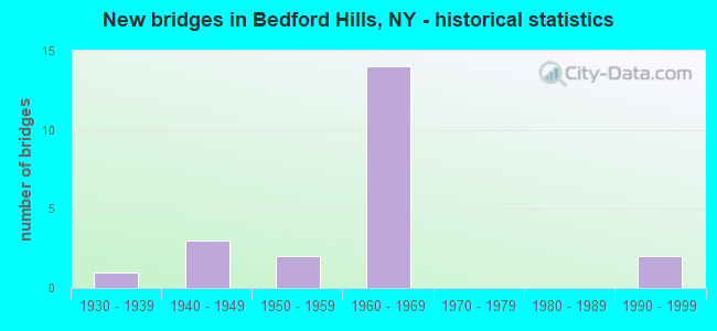
- New bridges - historical statistics
- 11930-1939
- 31940-1949
- 21950-1959
- 141960-1969
- 21990-1999

- Reconstructed bridges - Historical Statistics
- 21980-1989
- 01990-1999
- 02000-2009
- 02010-2019
- 12020-2022


- Bridge Condition - Deck
- 10.0%Excellent
- 10.0%Very good
- 50.0%Good
- 30.0%Fair

- Bridge Condition - Superstructure
- 60.0%Good
- 10.0%Satisfactory
- 30.0%Fair

- Bridge Condition - Substructure
- 30.0%Good
- 50.0%Satisfactory
- 10.0%Fair
- 10.0%Serious

- Bridge Condition - Channel
- 14.3%Very good
- 28.6%Satisfactory
- 42.9%Fair
- 14.3%Poor
Find on map >> Show street view
Structure Number: 10372, Location: 2.5 MI S JCT RTS 117+35 (Lat: 41.236222, Lng: -73.701653), Route carried "on" structure: State highway 117, Year Built: 1942, Status: Open, Structure Length: 4.33m (14.21ft), Average Daily Traffic: 13,871 (year 2015), Truck Traffic: 5%, Average Future Daily Traffic: 13,936 (year 2040), Features Intersected: PARKING ACCESS ROAD, MNR
Minimum Vertical Clearance: 30+ m (98+ ft), Kilometerpoint: 21.577, Lanes on structure: 4, Base Highway Network: Yes, Owner: State Highway Agency, Approaching Roadway Width: 13.4m (44.0ft), Skew: 5 degrees, Material/Design: Steel, Design/Construction: Stringer/Multi-beam, Number Of Spans In Main Unit: 2, Length of Maximum Span: 20.4m (66.9ft), Curb or Sidewalk Widths: Left: 1.5m (4.9ft), Right: 1.5m (4.9ft), Curb-To-Curb Width: 13.4m (44.0ft), Out-to-Out Width: 17.0m (55.8ft)
Condition: Deck: Fair, Superstructure: Fair, Substructure: Serious, Operating Rating: 46.3 metric tons, Method Used To Determine Operating Rating: Load Factor (LF), Inventory Rating: 27.2 metric tons, Method Used To Determine Inventory Rating: Load Factor (LF), Structural Evaluation: High priority of corrective action, Deck Geometry: High priority of replacement, Underclear: Meets minimum limits, Approach Roadway Alignment: Meets minimum limits, Length Of Structure Improvement: 4.32m (14.17ft), Designated Inspection Frequency: Every 24 months, Inspection Date: September 2021, Bridge Improvement Cost: $6,075,000, Roadway Improvement Cost: $3,557,000, Total Project Cost: $9,632,000 ( Estimate for 2021), Deck Structure Type: Concrete Cast-file-Place, Wearing Surface/Protective System: Wearing Surface: Bituminous
Find on map >> Show street view
Structure Number: 103721, Location: 2.4 MI S JCT RTS 117+35 (Lat: 41.237731, Lng: -73.701181), Route carried "on" structure: State highway 117, Year Built: 1942, Status: Open, Structure Length: 3.02m (9.91ft), Average Daily Traffic: 13,871 (year 2019), Truck Traffic: 8%, Average Future Daily Traffic: 13,936 (year 2040), Design Load: H 20, Features Intersected: 987D 987D87012305 SB, RT
Minimum Vertical Clearance: 30+ m (98+ ft), Kilometerpoint: 21.722, Lanes on structure: 4, Lanes under structure: 4, Base Highway Network: Yes, Owner: State Highway Agency, Approaching Roadway Width: 13.4m (44.0ft), Skew: 4 degrees, Material/Design: Steel, Design/Construction: Stringer/Multi-beam, Number Of Spans In Main Unit: 2, Length of Maximum Span: 14.9m (48.9ft), Curb or Sidewalk Widths: Left: 1.5m (4.9ft), Right: 1.5m (4.9ft), Curb-To-Curb Width: 13.4m (44.0ft), Out-to-Out Width: 17.0m (55.8ft)
Condition: Deck: Fair, Superstructure: Fair, Substructure: Satisfactory, Operating Rating: 37.9 metric tons, Method Used To Determine Operating Rating: Load and Resistance Factor Rating (LRFR) rating reported by rating factor(RF) method using HL-93 loadings, Inventory Rating: 29.2 metric tons, Method Used To Determine Inventory Rating: Load and Resistance Factor Rating (LRFR) rating reported by rating factor(RF) method using HL-93 loadings, Structural Evaluation: Somewhat better than minimum adequacy, Deck Geometry: High priority of replacement, Underclear: High priority of corrective action, Approach Roadway Alignment: Meets minimum limits, Length Of Structure Improvement: 3.01m (9.88ft), Designated Inspection Frequency: Every 24 months, Inspection Date: July 2020, Bridge Improvement Cost: $4,342,000, Roadway Improvement Cost: $2,543,000, Total Project Cost: $6,885,000 ( Estimate for 2021), Deck Structure Type: Concrete Cast-file-Place, Wearing Surface/Protective System: Wearing Surface: Bituminous
Find on map >> Show street view
Structure Number: 105309, Location: 1.8 MI N JCT RTS I684+172 (Lat: 41.220108, Lng: -73.685706), Route carried "on" structure: Other road , Year Built: 1968, Year Reconstructed: 2020, Status: Open, Structure Length: 10.21m (33.50ft), Average Daily Traffic: 361 (year 2017), Truck Traffic: 4%, Average Future Daily Traffic: 505 (year 2037), Design Load: HS 20, Features Intersected: 684I684I87011144, RTE I6, Facility Carried by Structure: BROAD BROOK RD
Minimum Vertical Clearance: 30+ m (98+ ft), Kilometerpoint: 1.207, Lanes on structure: 2, Lanes under structure: 6, Owner: State Highway Agency, Approaching Roadway Width: 9.8m (32.2ft), Material/Design: Steel, Design/Construction: Stringer/Multi-beam, Number Of Spans In Main Unit: 3, Length of Maximum Span: 34.1m (111.9ft), Curb-To-Curb Width: 9.8m (32.2ft), Out-to-Out Width: 11.0m (36.1ft)
Condition: Deck: Excellent, Superstructure: Good, Substructure: Good, Channel: Very good, Operating Rating: 34.3 metric tons, Method Used To Determine Operating Rating: Load and Resistance Factor Rating (LRFR) rating reported by rating factor(RF) method using HL-93 loadings, Inventory Rating: 26.6 metric tons, Method Used To Determine Inventory Rating: Load and Resistance Factor Rating (LRFR) rating reported by rating factor(RF) method using HL-93 loadings, Structural Evaluation: Equal to present minimum criteria, Deck Geometry: Better than present minimum criteria, Underclear: High priority of corrective action, Waterway Adequacy: Equal to present desirable criteria, Approach Roadway Alignment: Equal to present desirable criteria, Length Of Structure Improvement: 10.21m (33.50ft), Designated Inspection Frequency: Every 24 months, Inspection Date: November 2020, Bridge Improvement Cost: $4,566,000, Roadway Improvement Cost: $2,674,000, Total Project Cost: $7,240,000 ( Estimate for 2021), Deck Structure Type: Concrete Cast-file-Place, Wearing Surface/Protective System: Wearing Surface: Integral Concrete, Deck Protection: Epoxy Coated Reinforcing
Find on map >> Show street view
Structure Number: 1053101, Location: 2.2 MI N JCT I684 & SH172 (Lat: 41.225953, Lng: -73.683656), Route carried "on" structure: Interstate 684, Year Built: 1966, Status: Open, Structure Length: 2.96m (9.71ft), Average Daily Traffic: 28,096 (year 2000), Truck Traffic: 15%, Design Load: HS 20, Features Intersected: CR98-BEDFD CTR RD
Minimum Vertical Clearance: 30+ m (98+ ft), Kilometerpoint: 23.829, Lanes on structure: 3, Lanes under structure: 2, Base Highway Network: Yes, Owner: State Highway Agency, Approaching Roadway Width: 15.5m (50.9ft), Skew: 2 degrees, Material/Design: Steel, Design/Construction: Stringer/Multi-beam, Number Of Spans In Main Unit: 1, Length of Maximum Span: 28.0m (91.9ft), Curb-To-Curb Width: 15.9m (52.2ft), Out-to-Out Width: 16.7m (54.8ft)
Condition: Deck: Very good, Superstructure: Good, Substructure: Good, Operating Rating: 54.1 metric tons, Method Used To Determine Operating Rating: Load and Resistance Factor Rating (LRFR) rating reported by rating factor(RF) method using HL-93 loadings, Inventory Rating: 41.8 metric tons, Method Used To Determine Inventory Rating: Load and Resistance Factor Rating (LRFR) rating reported by rating factor(RF) method using HL-93 loadings, Structural Evaluation: Better than present minimum criteria, Deck Geometry: Somewhat better than minimum adequacy, Underclear: Somewhat better than minimum adequacy, Approach Roadway Alignment: Equal to present desirable criteria, Length Of Structure Improvement: 2.95m (9.68ft), Designated Inspection Frequency: Every 24 months, Inspection Date: June 2020, Bridge Improvement Cost: $2,449,000, Roadway Improvement Cost: $1,434,000, Total Project Cost: $3,883,000 ( Estimate for 2021), Deck Structure Type: Concrete Cast-file-Place, Wearing Surface/Protective System: Wearing Surface: Monolithic Concrete
Find on map >> Show street view
Structure Number: 1053102, Location: 2.2 MI N JCT I684 & SH172 (Lat: 41.225581, Lng: -73.683061), Route carried "on" structure: Interstate 684, Year Built: 1966, Status: Open, Structure Length: 2.96m (9.71ft), Average Daily Traffic: 26,716 (year 2020), Truck Traffic: 11%, Average Future Daily Traffic: 45,241 (year 2040), Design Load: HS 20, Features Intersected: CR98-BEDFD CTR RD
Minimum Vertical Clearance: 30+ m (98+ ft), Kilometerpoint: 23.878, Lanes on structure: 3, Lanes under structure: 2, Base Highway Network: Yes, Owner: State Highway Agency, Approaching Roadway Width: 16.2m (53.1ft), Skew: 2 degrees, Material/Design: Steel, Design/Construction: Stringer/Multi-beam, Number Of Spans In Main Unit: 1, Length of Maximum Span: 28.0m (91.9ft), Curb-To-Curb Width: 15.9m (52.2ft), Out-to-Out Width: 16.7m (54.8ft)
Condition: Deck: Good, Superstructure: Satisfactory, Substructure: Satisfactory, Operating Rating: 57.0 metric tons, Method Used To Determine Operating Rating: Load and Resistance Factor Rating (LRFR) rating reported by rating factor(RF) method using HL-93 loadings, Inventory Rating: 44.1 metric tons, Method Used To Determine Inventory Rating: Load and Resistance Factor Rating (LRFR) rating reported by rating factor(RF) method using HL-93 loadings, Structural Evaluation: Equal to present minimum criteria, Deck Geometry: Somewhat better than minimum adequacy, Underclear: Somewhat better than minimum adequacy, Approach Roadway Alignment: Equal to present desirable criteria, Length Of Structure Improvement: 2.95m (9.68ft), Designated Inspection Frequency: Every 24 months, Inspection Date: June 2020, Bridge Improvement Cost: $2,631,000, Roadway Improvement Cost: $1,541,000, Total Project Cost: $4,172,000 ( Estimate for 2021), Deck Structure Type: Concrete Cast-file-Place, Wearing Surface/Protective System: Wearing Surface: Monolithic Concrete
Find on map >> Show street view
Structure Number: 1053111, Location: 3.2 MI N JCT RTS I684+172 (Lat: 41.240164, Lng: -73.675900), Route carried "on" structure: Interstate 684, Year Built: 1966, Status: Open, Structure Length: 3.44m (11.29ft), Average Daily Traffic: 28,096 (year 2000), Truck Traffic: 15%, Design Load: HS 20, Features Intersected: HARRIS ROAD
Minimum Vertical Clearance: 30+ m (98+ ft), Kilometerpoint: 25.535, Lanes on structure: 3, Lanes under structure: 2, Base Highway Network: Yes, Owner: State Highway Agency, Approaching Roadway Width: 15.8m (51.8ft), Skew: 3 degrees, Material/Design: Steel, Design/Construction: Stringer/Multi-beam, Number Of Spans In Main Unit: 1, Length of Maximum Span: 32.9m (107.9ft), Curb-To-Curb Width: 15.5m (50.9ft), Out-to-Out Width: 16.7m (54.8ft)
Condition: Deck: Good, Superstructure: Good, Substructure: Satisfactory, Operating Rating: 48.3 metric tons, Method Used To Determine Operating Rating: Load and Resistance Factor Rating (LRFR) rating reported by rating factor(RF) method using HL-93 loadings, Inventory Rating: 37.3 metric tons, Method Used To Determine Inventory Rating: Load and Resistance Factor Rating (LRFR) rating reported by rating factor(RF) method using HL-93 loadings, Structural Evaluation: Equal to present minimum criteria, Deck Geometry: Somewhat better than minimum adequacy, Underclear: Meets minimum limits, Approach Roadway Alignment: Equal to present desirable criteria, Length Of Structure Improvement: 3.44m (11.29ft), Designated Inspection Frequency: Every 24 months, Inspection Date: June 2020, Bridge Improvement Cost: $3,369,000, Roadway Improvement Cost: $1,973,000, Total Project Cost: $5,342,000 ( Estimate for 2021), Deck Structure Type: Concrete Cast-file-Place, Wearing Surface/Protective System: Wearing Surface: Monolithic Concrete
Find on map >> Show street view
Structure Number: 1053112, Location: 3.2 MI N JCT I684 & SH172 (Lat: 41.239708, Lng: -73.675300), Route carried "on" structure: Interstate 684, Year Built: 1966, Status: Open, Structure Length: 3.44m (11.29ft), Average Daily Traffic: 26,716 (year 2020), Truck Traffic: 11%, Average Future Daily Traffic: 45,241 (year 2040), Design Load: HS 20, Features Intersected: HARRIS ROAD
Minimum Vertical Clearance: 30+ m (98+ ft), Kilometerpoint: 25.567, Lanes on structure: 3, Lanes under structure: 2, Base Highway Network: Yes, Owner: State Highway Agency, Approaching Roadway Width: 15.8m (51.8ft), Skew: 2 degrees, Material/Design: Steel, Design/Construction: Stringer/Multi-beam, Number Of Spans In Main Unit: 1, Length of Maximum Span: 32.9m (107.9ft), Curb-To-Curb Width: 15.5m (50.9ft), Out-to-Out Width: 16.7m (54.8ft)
Condition: Deck: Good, Superstructure: Good, Substructure: Satisfactory, Operating Rating: 46.3 metric tons, Method Used To Determine Operating Rating: Load and Resistance Factor Rating (LRFR) rating reported by rating factor(RF) method using HL-93 loadings, Inventory Rating: 35.6 metric tons, Method Used To Determine Inventory Rating: Load and Resistance Factor Rating (LRFR) rating reported by rating factor(RF) method using HL-93 loadings, Structural Evaluation: Equal to present minimum criteria, Deck Geometry: Somewhat better than minimum adequacy, Underclear: Equal to present minimum criteria, Approach Roadway Alignment: Equal to present desirable criteria, Length Of Structure Improvement: 3.44m (11.29ft), Designated Inspection Frequency: Every 24 months, Inspection Date: June 2020, Bridge Improvement Cost: $2,949,000, Roadway Improvement Cost: $1,727,000, Total Project Cost: $4,677,000 ( Estimate for 2021), Deck Structure Type: Concrete Cast-file-Place, Wearing Surface/Protective System: Wearing Surface: Monolithic Concrete
Find on map >> Show street view
Structure Number: 1091141, Location: 1.4 MI N I684 - EXIT 4 (Lat: 41.211347, Lng: -73.685978), Route carried "on" structure: Interstate 684, Year Built: 1968, Status: Open, Structure Length: 0.85m (2.79ft), Average Daily Traffic: 28,096 (year 2000), Truck Traffic: 15%, Design Load: HS 20, Features Intersected: BROAD BROOK
Minimum Vertical Clearance: 30+ m (98+ ft), Kilometerpoint: 22.848, Lanes on structure: 3, Base Highway Network: Yes, Owner: State Highway Agency, Approaching Roadway Width: 15.8m (51.8ft), Skew: 3 degrees, Material/Design: Concrete, Design/Construction: Culvert, Number Of Spans In Main Unit: 3, Length of Maximum Span: 2.4m (7.9ft)
Condition: Channel: Fair, Culverts: Good, Operating Rating: 97.2 metric tons, Method Used To Determine Operating Rating: Load and Resistance Factor Rating (LRFR) rating reported by rating factor(RF) method using HL-93 loadings, Inventory Rating: 96.6 metric tons, Method Used To Determine Inventory Rating: Load and Resistance Factor Rating (LRFR) rating reported by rating factor(RF) method using HL-93 loadings, Structural Evaluation: Better than present minimum criteria, Waterway Adequacy: Meets minimum limits, Approach Roadway Alignment: Equal to present desirable criteria, Length Of Structure Improvement: 0.85m (2.79ft), Designated Inspection Frequency: Every 24 months, Inspection Date: June 2020, Bridge Improvement Cost: $381,000, Roadway Improvement Cost: $223,000, Total Project Cost: $604,000 ( Estimate for 2021), Wearing Surface/Protective System: Wearing Surface: Bituminous
Find on map >> Show street view
Structure Number: 1091142, Location: 1.4 MI N EXIT 4 OF I684 (Lat: 41.210489, Lng: -73.685383), Route carried "on" structure: Interstate 684, Year Built: 1968, Status: Open, Structure Length: 0.85m (2.79ft), Average Daily Traffic: 26,716 (year 2020), Truck Traffic: 11%, Average Future Daily Traffic: 45,241 (year 2040), Design Load: HS 20, Features Intersected: BROAD BROOK
Minimum Vertical Clearance: 30+ m (98+ ft), Kilometerpoint: 22.188, Lanes on structure: 3, Base Highway Network: Yes, Owner: State Highway Agency, Approaching Roadway Width: 15.8m (51.8ft), Skew: 1 degrees, Material/Design: Concrete, Design/Construction: Culvert, Number Of Spans In Main Unit: 3, Length of Maximum Span: 2.4m (7.9ft)
Condition: Channel: Poor, Culverts: Good, Operating Rating: 97.2 metric tons, Method Used To Determine Operating Rating: Load and Resistance Factor Rating (LRFR) rating reported by rating factor(RF) method using HL-93 loadings, Inventory Rating: 96.6 metric tons, Method Used To Determine Inventory Rating: Load and Resistance Factor Rating (LRFR) rating reported by rating factor(RF) method using HL-93 loadings, Structural Evaluation: Better than present minimum criteria, Waterway Adequacy: Meets minimum limits, Approach Roadway Alignment: Equal to present desirable criteria, Length Of Structure Improvement: 0.85m (2.79ft), Designated Inspection Frequency: Every 24 months, Inspection Date: June 2020, Bridge Improvement Cost: $381,000, Roadway Improvement Cost: $223,000, Total Project Cost: $604,000 ( Estimate for 2021), Wearing Surface/Protective System: Wearing Surface: Bituminous
Find on map >> Show street view
Structure Number: 1091151, Location: 1.8 MI N RTE I684 INT 4 (Lat: 41.220483, Lng: -73.685622), Route carried "on" structure: Interstate 684, Year Built: 1968, Status: Open, Structure Length: 1.68m (5.51ft), Average Daily Traffic: 28,096 (year 2000), Truck Traffic: 15%, Design Load: HS 20, Features Intersected: BROAD BROOK
Minimum Vertical Clearance: 30+ m (98+ ft), Kilometerpoint: 23.250, Lanes on structure: 3, Base Highway Network: Yes, Owner: State Highway Agency, Approaching Roadway Width: 15.8m (51.8ft), Skew: 4 degrees, Material/Design: Concrete continuous, Design/Construction: Culvert, Number Of Spans In Main Unit: 5, Length of Maximum Span: 3.0m (9.8ft), Curb-To-Curb Width: 15.8m (51.8ft), Out-to-Out Width: 21.0m (68.9ft)
Condition: Channel: Fair, Culverts: Good, Structural Evaluation: Better than present minimum criteria, Deck Geometry: Somewhat better than minimum adequacy, Waterway Adequacy: Meets minimum limits, Approach Roadway Alignment: Equal to present desirable criteria, Length Of Structure Improvement: 1.67m (5.48ft), Designated Inspection Frequency: Every 24 months, Inspection Date: April 2020, Bridge Improvement Cost: $1,210,000, Roadway Improvement Cost: $709,000, Total Project Cost: $1,919,000 ( Estimate for 2021), Wearing Surface/Protective System: Wearing Surface: Bituminous
Find on map >> Show street view
Structure Number: 1091152, Location: 1.7 MI N RTE I684 INT 4 (Lat: 41.218731, Lng: -73.685131), Route carried "on" structure: Interstate 684, Year Built: 1968, Status: Open, Structure Length: 1.95m (6.40ft), Average Daily Traffic: 26,716 (year 2020), Truck Traffic: 11%, Average Future Daily Traffic: 45,241 (year 2040), Design Load: HS 20, Features Intersected: BROAD BROOK
Minimum Vertical Clearance: 30+ m (98+ ft), Kilometerpoint: 23.105, Lanes on structure: 3, Base Highway Network: Yes, Owner: State Highway Agency, Approaching Roadway Width: 15.8m (51.8ft), Skew: 5 degrees, Material/Design: Concrete, Design/Construction: Culvert, Number Of Spans In Main Unit: 5, Length of Maximum Span: 3.3m (10.8ft), Curb-To-Curb Width: 15.8m (51.8ft), Out-to-Out Width: 18.3m (60.0ft)
Condition: Channel: Satisfactory, Culverts: Good, Structural Evaluation: Better than present minimum criteria, Deck Geometry: Somewhat better than minimum adequacy, Waterway Adequacy: Meets minimum limits, Approach Roadway Alignment: Equal to present desirable criteria, Length Of Structure Improvement: 1.95m (6.40ft), Designated Inspection Frequency: Every 24 months, Inspection Date: April 2020, Bridge Improvement Cost: $1,224,000, Roadway Improvement Cost: $717,000, Total Project Cost: $1,942,000 ( Estimate for 2021), Wearing Surface/Protective System: Wearing Surface: Bituminous
Find on map >> Show street view
Structure Number: 334832, Location: 2.9 MI NE OF MT KISCO (Lat: 41.228383, Lng: -73.688578), Route carried "on" structure: Other road , Year Built: 1998, Status: Open, Structure Length: 1.13m (3.71ft), Average Daily Traffic: 4,034 (year 2015), Truck Traffic: 5%, Average Future Daily Traffic: 4,991 (year 2040), Design Load: HS 20, Features Intersected: BROAD BROOK, Facility Carried by Structure: BEDFORD CENTER RD
Minimum Vertical Clearance: 32.69m (107.25ft), Kilometerpoint: 1.191, Lanes on structure: 2, Owner: County Highway Agency, Approaching Roadway Width: 9.8m (32.2ft), Material/Design: Concrete, Design/Construction: Frame, Number Of Spans In Main Unit: 1, Length of Maximum Span: 10.6m (34.8ft), Curb-To-Curb Width: 9.8m (32.2ft), Out-to-Out Width: 14.6m (47.9ft)
Condition: Deck: Good, Superstructure: Good, Substructure: Good, Channel: Fair, Operating Rating: 70.6 metric tons, Method Used To Determine Operating Rating: Load and Resistance Factor Rating (LRFR) rating reported by rating factor(RF) method using HL-93 loadings, Inventory Rating: 54.4 metric tons, Method Used To Determine Inventory Rating: Load and Resistance Factor Rating (LRFR) rating reported by rating factor(RF) method using HL-93 loadings, Structural Evaluation: Better than present minimum criteria, Deck Geometry: Meets minimum limits, Waterway Adequacy: Meets minimum limits, Approach Roadway Alignment: Equal to present desirable criteria, Length Of Structure Improvement: 1.12m (3.67ft), Designated Inspection Frequency: Every 24 months, Inspection Date: June 2021, Bridge Improvement Cost: $817,000, Roadway Improvement Cost: $478,000, Total Project Cost: $1,295,000 ( Estimate for 2021)
Find on map >> Show street view
Structure Number: 334841, Location: 4.2 MI NE OF MOUNT KISCO (Lat: 41.231314, Lng: -73.657747), Route carried "on" structure: Other road , Year Built: 1930, Year Reconstructed: 1993, Status: Open, Structure Length: 1.19m (3.90ft), Average Daily Traffic: 104 (year 2017), Truck Traffic: 4%, Average Future Daily Traffic: 146 (year 2037), Features Intersected: BEAVER DAM CREEK, Facility Carried by Structure: MATTHEWS MILL ROAD
Minimum Vertical Clearance: 30+ m (98+ ft), Kilometerpoint: 0.483, Lanes on structure: 1, Owner: County Highway Agency, Approaching Roadway Width: 4.3m (14.1ft), Material/Design: Prestressed concrete, Design/Construction: Box Beam or Girders - Multiple, Number Of Spans In Main Unit: 1, Length of Maximum Span: 10.3m (33.8ft), Curb-To-Curb Width: 4.2m (13.8ft), Out-to-Out Width: 5.5m (18.0ft)
Condition: Deck: Good, Superstructure: Good, Substructure: Fair, Channel: Satisfactory, Operating Rating: 41.8 metric tons, Method Used To Determine Operating Rating: Load and Resistance Factor Rating (LRFR) rating reported by rating factor(RF) method using HL-93 loadings, Inventory Rating: 31.1 metric tons, Method Used To Determine Inventory Rating: Load and Resistance Factor Rating (LRFR) rating reported by rating factor(RF) method using HL-93 loadings, Structural Evaluation: Somewhat better than minimum adequacy, Deck Geometry: High priority of replacement, Waterway Adequacy: Somewhat better than minimum adequacy, Approach Roadway Alignment: Equal to present minimum criteria, Length Of Structure Improvement: 1.18m (3.87ft), Designated Inspection Frequency: Every 24 months, Underwater Inspection Frequency: Every 60 months, Inspection Date: March 2021, Underwater Inspection Date: July 2020, Bridge Improvement Cost: $301,000, Roadway Improvement Cost: $176,000, Total Project Cost: $477,000 ( Estimate for 2021), Wearing Surface/Protective System: Wearing Surface: Bituminous
Find on map >> Show street view
Structure Number: 550098, Location: 1.0 MI E JCT RTS SMRP<117 (Lat: 41.245731, Lng: -73.685283), Route carried "on" structure: Other road 117, Year Built: 1954, Year Reconstructed: 1992, Status: Open, Structure Length: 2.29m (7.51ft), Average Daily Traffic: 4,579 (year 2019), Truck Traffic: 4%, Average Future Daily Traffic: 4,600 (year 2040), Design Load: HS 20, Features Intersected: 987DX SB, RTE 987D
Minimum Vertical Clearance: 30+ m (98+ ft), Kilometerpoint: 23.379, Lanes on structure: 3, Lanes under structure: 4, Owner: State Highway Agency, Approaching Roadway Width: 11.6m (38.1ft), Material/Design: Prestressed concrete, Design/Construction: Box Beam or Girders - Multiple, Number Of Spans In Main Unit: 1, Length of Maximum Span: 21.9m (71.9ft), Curb or Sidewalk Widths: Left: 0.0m, Right: 1.6m (5.2ft), Curb-To-Curb Width: 11.1m (36.4ft), Out-to-Out Width: 13.4m (44.0ft)
Condition: Deck: Fair, Superstructure: Fair, Substructure: Satisfactory, Operating Rating: 36.3 metric tons, Method Used To Determine Operating Rating: Load and Resistance Factor Rating (LRFR) rating reported by rating factor(RF) method using HL-93 loadings, Inventory Rating: 25.3 metric tons, Method Used To Determine Inventory Rating: Load and Resistance Factor Rating (LRFR) rating reported by rating factor(RF) method using HL-93 loadings, Structural Evaluation: Somewhat better than minimum adequacy, Deck Geometry: High priority of replacement, Underclear: High priority of corrective action, Approach Roadway Alignment: Equal to present desirable criteria, Length Of Structure Improvement: 2.28m (7.48ft), Designated Inspection Frequency: Every 24 months, Inspection Date: May 2020, Bridge Improvement Cost: $1,341,000, Roadway Improvement Cost: $786,000, Total Project Cost: $2,127,000 ( Estimate for 2021), Deck Structure Type: Other, Wearing Surface/Protective System: Wearing Surface: Monolithic Concrete
Find on map >> Show street view
Structure Number: 103721, Location: 2.4 MI S JCT RTS 117+35 (Lat: 41.237731, Lng: -73.701181), Route carried "under" structure: Other road 987D, Year Built: 1942, Structure Length: 0. m, Average Daily Traffic: 31,791 (year 2002), Features Intersected: 987D 987D87012305 SB, RT, Facility Carried by Structure: RTE 117
Minimum Vertical Clearance: 6.86m (22.51ft), Kilometerpoint: 35.511, Lanes on structure: 4, Lanes under structure: 2, Material/Design: Steel, Design/Construction: Stringer/Multi-beam, Length of Maximum Span: 14.9m (48.9ft)
Find on map >> Show street view
Structure Number: 105309, Location: 1.8 MI N JCT RTS I684+172 (Lat: 41.220108, Lng: -73.685706), Route carried "under" structure: Interstate 684, Year Built: 1968, Structure Length: 0. m, Average Daily Traffic: 58,616 (year 2002), Features Intersected: 684I684I87011144, RTE I6, Facility Carried by Structure: BROAD BROOK RD
Minimum Vertical Clearance: 5.11m (16.77ft), Kilometerpoint: 23.170, Lanes on structure: 2, Lanes under structure: 3, Material/Design: Steel, Design/Construction: Stringer/Multi-beam, Length of Maximum Span: 34.1m (111.9ft)
Find on map >> Show street view
Structure Number: 1053101, Location: 2.2 MI N JCT I684 & SH172 (Lat: 41.225953, Lng: -73.683656), Route carried "under" structure: County highway , Year Built: 1966, Structure Length: 0. m, Average Daily Traffic: 2,017 (year 2015), Truck Traffic: 5%, Features Intersected: CR98-BEDFD CTR RD, Facility Carried by Structure: RTE I684
Minimum Vertical Clearance: 4.59m (15.06ft), Kilometerpoint: 1.673, Lanes on structure: 3, Lanes under structure: 2, Material/Design: Steel, Design/Construction: Stringer/Multi-beam, Length of Maximum Span: 28.0m (91.9ft)
Find on map >> Show street view
Structure Number: 1053102, Location: 2.2 MI N JCT I684 & SH172 (Lat: 41.225581, Lng: -73.683061), Route carried "under" structure: County highway , Year Built: 1966, Structure Length: 0. m, Average Daily Traffic: 2,017 (year 2015), Truck Traffic: 5%, Features Intersected: CR98-BEDFD CTR RD, Facility Carried by Structure: RTE I684
Minimum Vertical Clearance: 4.44m (14.57ft), Kilometerpoint: 1.689, Lanes on structure: 3, Lanes under structure: 2, Material/Design: Steel, Design/Construction: Stringer/Multi-beam, Length of Maximum Span: 28.0m (91.9ft)
Find on map >> Show street view
Structure Number: 1053111, Location: 3.2 MI N JCT RTS I684+172 (Lat: 41.240164, Lng: -73.675900), Route carried "under" structure: Other road , Year Built: 1966, Structure Length: 0. m, Average Daily Traffic: 1,021 (year 2016), Truck Traffic: 3%, Features Intersected: HARRIS ROAD, Facility Carried by Structure: RTE I684
Minimum Vertical Clearance: 4.52m (14.83ft), Kilometerpoint: 2.349, Lanes on structure: 3, Lanes under structure: 2, Material/Design: Steel, Design/Construction: Stringer/Multi-beam, Length of Maximum Span: 32.9m (107.9ft)
Find on map >> Show street view
Structure Number: 1053112, Location: 3.2 MI N JCT I684 & SH172 (Lat: 41.239708, Lng: -73.675300), Route carried "under" structure: Other road , Year Built: 1966, Structure Length: 0. m, Average Daily Traffic: 1,021 (year 2016), Truck Traffic: 3%, Features Intersected: HARRIS ROAD, Facility Carried by Structure: RTE I684
Minimum Vertical Clearance: 4.87m (15.98ft), Kilometerpoint: 2.912, Lanes on structure: 3, Lanes under structure: 2, Material/Design: Steel, Design/Construction: Stringer/Multi-beam, Length of Maximum Span: 32.9m (107.9ft)
Find on map >> Show street view
Structure Number: 550098, Location: 1.0 MI E JCT RTS SMRP<117 (Lat: 41.245731, Lng: -73.685283), Route carried "under" structure: Other road 987D, Year Built: 1954, Structure Length: 0. m, Average Daily Traffic: 1,550 (year 2021), Features Intersected: 987DX SB, RTE 987D, Facility Carried by Structure: RTE 117
Minimum Vertical Clearance: 4.41m (14.47ft), Kilometerpoint: 45.696, Lanes on structure: 3, Lanes under structure: 2, Material/Design: Prestressed concrete, Design/Construction: Box Beam or Girders - Multiple, Length of Maximum Span: 21.9m (71.9ft)
Find on map >> Show street view
Structure Number: 771275, Location: 3.5 MI NE OF MOUNT KISCO (Lat: 41.245136, Lng: -73.684717), Route carried "under" structure: Other road , Year Built: 1992, Structure Length: 0. m, Truck Traffic: 3%, Features Intersected: HARRIS ROAD, Facility Carried by Structure: MNRR HA LINE
Minimum Vertical Clearance: 4.41m (14.47ft), Kilometerpoint: 2.993, Lanes under structure: 2, Material/Design: Steel, Design/Construction: Girder and Floorbeam System, Length of Maximum Span: 22.8m (74.8ft)