Bridge Statistics for Belfield, North Dakota (ND)
Condition, Traffic, Stress, Structural Evaluation, Project Costs
- National Bridge Inventory (NBI) Statistics
- 18Number of bridges
- 105ft / 32.4mTotal length
- $814,000Total costs
- 24,510Total average daily traffic
- 4,338Total average daily truck traffic
- National Bridge Inventory (NBI) Registered Bridges for Belfield
- No street view available for this location
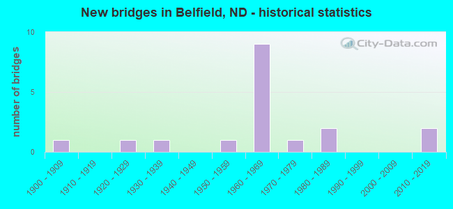
- New bridges - historical statistics
- 11900-1909
- 11920-1929
- 11930-1939
- 11950-1959
- 91960-1969
- 11970-1979
- 21980-1989
- 22010-2019

- Reconstructed bridges - Historical Statistics
- 11930-1939
- 01940-1949
- 01950-1959
- 11960-1969
- 01970-1979
- 31980-1989


- Bridge Condition - Deck
- 58.3%Good
- 41.7%Satisfactory

- Bridge Condition - Superstructure
- 8.3%Very good
- 41.7%Good
- 41.7%Satisfactory
- 8.3%Fair

- Bridge Condition - Substructure
- 16.7%Very good
- 25.0%Good
- 33.3%Satisfactory
- 25.0%Fair

- Bridge Condition - Channel
- 35.7%Very good
- 28.6%Good
- 35.7%Satisfactory

- Bridge Condition - Culverts
- 25.0%Very good
- 75.0%Good
Find on map >> Show street view
Structure Number: 411929, Location: 1 North 3 West Belfield (Lat: 46.911500, Lng: -103.252417), Route carried "on" structure: County highway , Year Built: 1901, Status: Posted for load, Structure Length: 0.62m (2.03ft), Average Daily Traffic: 10 (year 2019), Average Future Daily Traffic: 10 (year 2039), Design Load: HS 20, Features Intersected: Creek, Facility Carried by Structure: County Highway
Minimum Vertical Clearance: 30+ m (98+ ft), Kilometerpoint: 0.000, Lanes on structure: 2, Owner: County Highway Agency, Approaching Roadway Width: 4.9m (16.1ft), Material/Design: Wood or Timber, Design/Construction: Slab, Number Of Spans In Main Unit: 1, Length of Maximum Span: 6.2m (20.3ft), Curb or Sidewalk Widths: Left: 0.2m (0.7ft), Right: 0.2m (0.7ft), Curb-To-Curb Width: 5.2m (17.1ft), Out-to-Out Width: 5.7m (18.7ft)
Condition: Deck: Good, Superstructure: Good, Substructure: Satisfactory, Channel: Very good, Operating Rating: 18.2 metric tons, Method Used To Determine Operating Rating: Allowable Stress (AS), Inventory Rating: 13.3 metric tons, Method Used To Determine Inventory Rating: Allowable Stress (AS), Structural Evaluation: Meets minimum limits, Deck Geometry: High priority of corrective action, Waterway Adequacy: Superior to present desirable criteria, Approach Roadway Alignment: Better than present minimum criteria, Bridge Posting: Required (Relationship of Operating Rating to Maximum Legal Load: > 39.9% below), Designated Inspection Frequency: Every 24 months, Inspection Date: May 2021, Deck Structure Type: Wood or Timber, Wearing Surface/Protective System: Wearing Surface: Gravel
Find on map >> Show street view
Structure Number: 45101071, Location: 1 WEST 2 NORTH BELFIELD (Lat: 46.912567, Lng: -103.210842), Route carried "on" structure: County highway , Year Built: 1951, Status: Posted for load, Structure Length: 1.01m (3.31ft), Average Daily Traffic: 25 (year 2018), Average Future Daily Traffic: 25 (year 2038), Features Intersected: HEART RIVER, Facility Carried by Structure: 131ST AVE SW
Minimum Vertical Clearance: 30+ m (98+ ft), Kilometerpoint: 0.000, Lanes on structure: 2, Owner: County Highway Agency, Approaching Roadway Width: 5.5m (18.0ft), Material/Design: Steel, Design/Construction: Stringer/Multi-beam, Number Of Spans In Main Unit: 1, Length of Maximum Span: 9.4m (30.8ft), Curb or Sidewalk Widths: Left: 0.2m (0.7ft), Right: 0.2m (0.7ft), Curb-To-Curb Width: 5.2m (17.1ft), Out-to-Out Width: 5.6m (18.4ft)
Condition: Deck: Satisfactory, Superstructure: Fair, Substructure: Satisfactory, Channel: Satisfactory, Operating Rating: 14.7 metric tons, Method Used To Determine Operating Rating: Load Factor (LF), Inventory Rating: 8.8 metric tons, Method Used To Determine Inventory Rating: Load Factor (LF), Structural Evaluation: High priority of replacement, Deck Geometry: High priority of corrective action, Waterway Adequacy: Equal to present minimum criteria, Approach Roadway Alignment: Equal to present desirable criteria, Bridge Posting: Required (Relationship of Operating Rating to Maximum Legal Load: > 39.9% below), Length Of Structure Improvement: 3.02m (9.91ft), Designated Inspection Frequency: Every 24 months, Inspection Date: May 2021, Bridge Improvement Cost: $136,000, Roadway Improvement Cost: $14,000, Total Project Cost: $204,000, Deck Structure Type: Wood or Timber, Wearing Surface/Protective System: Wearing Surface: Wood or Timber
Find on map >> Show street view
Structure Number: 4510112, Location: 3 SOUTH 1 WEST BELFIELD (Lat: 46.839475, Lng: -103.210989), Route carried "on" structure: County highway , Year Built: 1971, Status: Posted for load, Structure Length: 1.07m (3.51ft), Average Daily Traffic: 24 (year 2018), Average Future Daily Traffic: 24 (year 2038), Features Intersected: NORWEGIAN CREEK, Facility Carried by Structure: 131st Ave SW
Minimum Vertical Clearance: 30+ m (98+ ft), Kilometerpoint: 0.000, Lanes on structure: 2, Owner: County Highway Agency, Approaching Roadway Width: 5.5m (18.0ft), Material/Design: Wood or Timber, Design/Construction: Stringer/Multi-beam, Number Of Spans In Main Unit: 1, Length of Maximum Span: 9.8m (32.2ft), Curb or Sidewalk Widths: Left: 0.2m (0.7ft), Right: 0.2m (0.7ft), Curb-To-Curb Width: 7.0m (23.0ft), Out-to-Out Width: 7.4m (24.3ft)
Condition: Deck: Satisfactory, Superstructure: Satisfactory, Substructure: Fair, Channel: Good, Operating Rating: 14.0 metric tons, Method Used To Determine Operating Rating: Load Factor (LF), Inventory Rating: 9.1 metric tons, Method Used To Determine Inventory Rating: Load Factor (LF), Structural Evaluation: High priority of replacement, Deck Geometry: Somewhat better than minimum adequacy, Waterway Adequacy: Equal to present minimum criteria, Approach Roadway Alignment: Equal to present minimum criteria, Bridge Posting: Required (Relationship of Operating Rating to Maximum Legal Load: > 39.9% below), Length Of Structure Improvement: 3.11m (10.20ft), Designated Inspection Frequency: Every 24 months, Inspection Date: May 2021, Bridge Improvement Cost: $140,000, Roadway Improvement Cost: $14,000, Total Project Cost: $210,000, Deck Structure Type: Wood or Timber, Wearing Surface/Protective System: Wearing Surface: Wood or Timber
Find on map >> Show street view
Structure Number: 4510207, Location: 1 NORTH OF BELFIELD (Lat: 46.904494, Lng: -103.200650), Route carried "on" structure: County highway , Year Built: 1964, Status: Open, Structure Length: 0.76m (2.49ft), Average Daily Traffic: 50 (year 2016), Average Future Daily Traffic: 50 (year 2036), Design Load: HS 20, Features Intersected: HEART RIVER, Facility Carried by Structure: COUNTY HIGHWAY
Minimum Vertical Clearance: 30+ m (98+ ft), Kilometerpoint: 0.000, Lanes on structure: 2, Owner: County Highway Agency, Approaching Roadway Width: 7.9m (25.9ft), Material/Design: Concrete, Design/Construction: Culvert, Number Of Spans In Main Unit: 3, Length of Maximum Span: 2.4m (7.9ft)
Condition: Channel: Very good, Culverts: Good, Operating Rating: 54.4 metric tons, Method Used To Determine Operating Rating: Field evaluation and documented engineering judgment, Inventory Rating: 32.7 metric tons, Method Used To Determine Inventory Rating: Field evaluation and documented engineering judgment, Structural Evaluation: Better than present minimum criteria, Waterway Adequacy: Equal to present minimum criteria, Approach Roadway Alignment: Equal to present desirable criteria, Designated Inspection Frequency: Every 48 months, Inspection Date: August 2020
Find on map >> Show street view
Structure Number: 4510208, Location: 6TH AVE WEST IN BELFIELD (Lat: 46.890731, Lng: -103.199572), Route carried "on" structure: City street 4510, Year Built: 1927, Year Reconstructed: 1937, Status: Open, Structure Length: 1.34m (4.40ft), Average Daily Traffic: 400 (year 2018), Truck Traffic: 10%, Average Future Daily Traffic: 450 (year 2038), Features Intersected: HEART RIVER, Facility Carried by Structure: 6TH AVENUE WEST
Minimum Vertical Clearance: 30+ m (98+ ft), Kilometerpoint: 2.414, Lanes on structure: 2, Owner: County Highway Agency, Approaching Roadway Width: 7.9m (25.9ft), Material/Design: Concrete, Design/Construction: Tee Beam, Number Of Spans In Main Unit: 1, Length of Maximum Span: 12.8m (42.0ft), Curb or Sidewalk Widths: Left: 0.2m (0.7ft), Right: 0.2m (0.7ft), Curb-To-Curb Width: 9.3m (30.5ft), Out-to-Out Width: 9.8m (32.2ft)
Condition: Deck: Satisfactory, Superstructure: Satisfactory, Substructure: Satisfactory, Channel: Satisfactory, Operating Rating: 32.7 metric tons, Method Used To Determine Operating Rating: Field evaluation and documented engineering judgment, Inventory Rating: 19.1 metric tons, Method Used To Determine Inventory Rating: Field evaluation and documented engineering judgment, Structural Evaluation: Somewhat better than minimum adequacy, Deck Geometry: Equal to present minimum criteria, Waterway Adequacy: Better than present minimum criteria, Approach Roadway Alignment: Equal to present desirable criteria, Designated Inspection Frequency: Every 24 months, Inspection Date: May 2021, Deck Structure Type: Concrete Cast-file-Place, Wearing Surface/Protective System: Wearing Surface: Bituminous
Find on map >> Show street view
Structure Number: 4510209, Location: 2ND AVE & 2ND ST NW-BELFI (Lat: 46.886703, Lng: -103.200822), Route carried "on" structure: City street , Year Built: 1930, Year Reconstructed: 1974, Status: Posted for load, Structure Length: 0.98m (3.22ft), Average Daily Traffic: 40 (year 2018), Average Future Daily Traffic: 40 (year 2038), Features Intersected: HEART RIVER, Facility Carried by Structure: 2nd AVENUE NW
Minimum Vertical Clearance: 30+ m (98+ ft), Kilometerpoint: 0.000, Lanes on structure: 2, Owner: County Highway Agency, Approaching Roadway Width: 15.2m (49.9ft), Material/Design: Steel, Design/Construction: Stringer/Multi-beam, Number Of Spans In Main Unit: 1, Length of Maximum Span: 9.1m (29.9ft), Curb or Sidewalk Widths: Left: 1.2m (3.9ft), Right: 0.0m, Curb-To-Curb Width: 7.3m (24.0ft), Out-to-Out Width: 7.3m (24.0ft)
Condition: Deck: Satisfactory, Superstructure: Satisfactory, Substructure: Fair, Channel: Good, Operating Rating: 19.9 metric tons, Method Used To Determine Operating Rating: Load Factor (LF), Inventory Rating: 11.7 metric tons, Method Used To Determine Inventory Rating: Load Factor (LF), Structural Evaluation: Meets minimum limits, Deck Geometry: Equal to present minimum criteria, Waterway Adequacy: Equal to present minimum criteria, Approach Roadway Alignment: Somewhat better than minimum adequacy, Bridge Posting: Required (Relationship of Operating Rating to Maximum Legal Load: 30.0 - 39.9% below), Length Of Structure Improvement: 0.98m (3.22ft), Designated Inspection Frequency: Every 24 months, Inspection Date: May 2021, Bridge Improvement Cost: $19,000, Roadway Improvement Cost: $2,000, Total Project Cost: $29,000, Deck Structure Type: Wood or Timber, Wearing Surface/Protective System: Wearing Surface: Wood or Timber
Find on map >> Show street view
Structure Number: 45102092, Location: 2ND AVE NE BELFIELD (Lat: 46.886325, Lng: -103.196647), Route carried "on" structure: City street , Year Built: 1988, Status: Open, Structure Length: 2.07m (6.79ft), Average Daily Traffic: 1,300 (year 2018), Truck Traffic: 5%, Average Future Daily Traffic: 1,300 (year 2038), Design Load: HS 20, Features Intersected: HEART RIVER, Facility Carried by Structure: 2ND AVE NE
Minimum Vertical Clearance: 30+ m (98+ ft), Kilometerpoint: 0.000, Lanes on structure: 2, Owner: County Highway Agency, Approaching Roadway Width: 9.1m (29.9ft), Skew: 2 degrees, Material/Design: Prestressed concrete, Design/Construction: Box Beam or Girders - Single/Spread, Number Of Spans In Main Unit: 1, Length of Maximum Span: 19.5m (64.0ft), Curb or Sidewalk Widths: Left: 0.0m, Right: 1.6m (5.2ft), Curb-To-Curb Width: 9.2m (30.2ft), Out-to-Out Width: 11.8m (38.7ft)
Condition: Deck: Good, Superstructure: Very good, Substructure: Very good, Channel: Very good, Operating Rating: 54.2 metric tons, Method Used To Determine Operating Rating: Load Factor (LF), Inventory Rating: 24.5 metric tons, Method Used To Determine Inventory Rating: Load Factor (LF), Structural Evaluation: Equal to present minimum criteria, Deck Geometry: Somewhat better than minimum adequacy, Waterway Adequacy: Equal to present desirable criteria, Approach Roadway Alignment: Equal to present desirable criteria, Designated Inspection Frequency: Every 24 months, Inspection Date: May 2021, Deck Structure Type: Concrete Cast-file-Place, Wearing Surface/Protective System: Wearing Surface: Monolithic Concrete
Find on map >> Show street view
Structure Number: 45102093, Location: MAIN STREET IN BELFIELD (Lat: 46.888561, Lng: -103.198828), Route carried "on" structure: City street , Year Built: 1967, Status: Open, Structure Length: 1.83m (6.00ft), Average Daily Traffic: 1,800 (year 2018), Truck Traffic: 3%, Average Future Daily Traffic: 1,800 (year 2038), Features Intersected: HEART RIVER, Facility Carried by Structure: MAIN STREET
Minimum Vertical Clearance: 30+ m (98+ ft), Kilometerpoint: 0.000, Lanes on structure: 2, Owner: County Highway Agency, Approaching Roadway Width: 15.2m (49.9ft), Material/Design: Prestressed concrete, Design/Construction: Box Beam or Girders - Multiple, Number Of Spans In Main Unit: 1, Length of Maximum Span: 18.0m (59.1ft), Curb or Sidewalk Widths: Left: 1.3m (4.3ft), Right: 0.0m, Curb-To-Curb Width: 8.6m (28.2ft), Out-to-Out Width: 10.1m (33.1ft)
Condition: Deck: Satisfactory, Superstructure: Satisfactory, Substructure: Satisfactory, Channel: Satisfactory, Operating Rating: 37.6 metric tons, Method Used To Determine Operating Rating: Load Factor (LF), Inventory Rating: 17.2 metric tons, Method Used To Determine Inventory Rating: Load Factor (LF), Structural Evaluation: Meets minimum limits, Deck Geometry: Somewhat better than minimum adequacy, Waterway Adequacy: Better than present minimum criteria, Approach Roadway Alignment: Equal to present desirable criteria, Length Of Structure Improvement: 1.83m (6.00ft), Designated Inspection Frequency: Every 24 months, Inspection Date: May 2021, Bridge Improvement Cost: $47,000, Roadway Improvement Cost: $5,000, Total Project Cost: $71,000, Deck Structure Type: Other
Find on map >> Show street view
Structure Number: 4510311, Location: 2 SOUTH 0.5 EAST BELFIELD (Lat: 46.839500, Lng: -103.211000), Route carried "on" structure: County highway , Year Built: 2016, Status: Open, Structure Length: 0.71m (2.33ft), Average Daily Traffic: 24 (year 2018), Average Future Daily Traffic: 24 (year 2038), Design Load: HS 25 or greater, Features Intersected: NORWEGIAN CREEK, Facility Carried by Structure: 39th ST SW
Minimum Vertical Clearance: 30+ m (98+ ft), Kilometerpoint: 0.000, Lanes on structure: 2, Owner: County Highway Agency, Approaching Roadway Width: 5.5m (18.0ft), Material/Design: Concrete, Design/Construction: Culvert, Number Of Spans In Main Unit: 2, Length of Maximum Span: 3.4m (11.2ft)
Condition: Channel: Very good, Culverts: Good, Operating Rating: 68.0 metric tons, Method Used To Determine Operating Rating: Load Factor (LF), Inventory Rating: 40.8 metric tons, Method Used To Determine Inventory Rating: Load Factor (LF), Structural Evaluation: Better than present minimum criteria, Waterway Adequacy: Superior to present desirable criteria, Approach Roadway Alignment: Equal to present desirable criteria, Length Of Structure Improvement: 3.11m (10.20ft), Designated Inspection Frequency: Every 48 months, Inspection Date: May 2021, Bridge Improvement Cost: $140,000, Roadway Improvement Cost: $14,000, Total Project Cost: $210,000
Find on map >> Show street view
Structure Number: 4510409, Location: 2 EAST BELFIELD (Lat: 46.876281, Lng: -103.152056), Route carried "on" structure: County highway , Year Built: 1981, Status: Open, Structure Length: 2.13m (6.99ft), Average Daily Traffic: 50 (year 2018), Average Future Daily Traffic: 50 (year 2038), Design Load: H 20, Features Intersected: HEART RIVER, Facility Carried by Structure: 37th St SW
Minimum Vertical Clearance: 30+ m (98+ ft), Kilometerpoint: 0.000, Lanes on structure: 2, Owner: County Highway Agency, Approaching Roadway Width: 7.3m (24.0ft), Material/Design: Prestressed concrete, Design/Construction: Box Beam or Girders - Single/Spread, Number Of Spans In Main Unit: 1, Length of Maximum Span: 20.1m (65.9ft), Curb-To-Curb Width: 8.5m (27.9ft), Out-to-Out Width: 10.1m (33.1ft)
Condition: Deck: Good, Superstructure: Good, Substructure: Very good, Channel: Satisfactory, Operating Rating: 38.5 metric tons, Method Used To Determine Operating Rating: Load Factor (LF), Inventory Rating: 18.2 metric tons, Method Used To Determine Inventory Rating: Load Factor (LF), Structural Evaluation: Somewhat better than minimum adequacy, Deck Geometry: Better than present minimum criteria, Waterway Adequacy: Equal to present desirable criteria, Approach Roadway Alignment: Equal to present desirable criteria, Designated Inspection Frequency: Every 24 months, Inspection Date: May 2021, Deck Structure Type: Concrete Cast-file-Place, Wearing Surface/Protective System: Wearing Surface: Gravel
Find on map >> Show street view
Structure Number: 451051, Location: 3 EAST BELFIELD (Lat: 46.875147, Lng: -103.126608), Route carried "on" structure: County highway , Year Built: 2019, Status: Open, Structure Length: 0.61m (2.00ft), Average Daily Traffic: 26 (year 2019), Average Future Daily Traffic: 26 (year 2039), Design Load: HL 93, Features Intersected: HEART RIVER, Facility Carried by Structure: 127th AVE SW
Minimum Vertical Clearance: 30+ m (98+ ft), Kilometerpoint: 0.000, Lanes on structure: 2, Owner: County Highway Agency, Approaching Roadway Width: 5.5m (18.0ft), Material/Design: Concrete, Design/Construction: Culvert, Number Of Spans In Main Unit: 1, Length of Maximum Span: 6.1m (20.0ft)
Condition: Channel: Very good, Culverts: Very good, Operating Rating: 68.0 metric tons, Method Used To Determine Operating Rating: Load Factor (LF), Inventory Rating: 40.8 metric tons, Method Used To Determine Inventory Rating: Load Factor (LF), Structural Evaluation: Equal to present desirable criteria, Waterway Adequacy: Superior to present desirable criteria, Approach Roadway Alignment: Equal to present desirable criteria, Length Of Structure Improvement: 0.98m (3.22ft), Designated Inspection Frequency: Every 24 months, Inspection Date: May 2021, Bridge Improvement Cost: $60,000, Roadway Improvement Cost: $6,000, Total Project Cost: $90,000
Find on map >> Show street view
Structure Number: 85072196, Location: 4 SOUTH OF JCT. I-94 (Lat: 46.845300, Lng: -103.189500), Route carried "on" structure: US 85, Year Built: 1968, Status: Open, Structure Length: 3.05m (10.01ft), Average Daily Traffic: 1,260 (year 2019), Truck Traffic: 21%, Average Future Daily Traffic: 1,260 (year 2039), Design Load: HS 20, Features Intersected: NORWEGIAN CREEK
Minimum Vertical Clearance: 30+ m (98+ ft), Kilometerpoint: 116.163, Lanes on structure: 2, Base Highway Network: Yes, Owner: State Highway Agency, Approaching Roadway Width: 12.2m (40.0ft), Material/Design: Concrete continuous, Design/Construction: Tee Beam, Number Of Spans In Main Unit: 3, Length of Maximum Span: 11.6m (38.1ft), Curb-To-Curb Width: 11.0m (36.1ft), Out-to-Out Width: 12.6m (41.3ft)
Condition: Deck: Good, Superstructure: Good, Substructure: Good, Channel: Good, Operating Rating: 65.2 metric tons, Method Used To Determine Operating Rating: Load Factor (LF), Inventory Rating: 39.0 metric tons, Method Used To Determine Inventory Rating: Load Factor (LF), Structural Evaluation: Better than present minimum criteria, Deck Geometry: Equal to present minimum criteria, Waterway Adequacy: Better than present minimum criteria, Approach Roadway Alignment: Better than present minimum criteria, Designated Inspection Frequency: Every 24 months, Inspection Date: May 2021, Deck Structure Type: Concrete Cast-file-Place, Wearing Surface/Protective System: Wearing Surface: Low Slump Concrete
Find on map >> Show street view
Structure Number: 85074754, Location: 1 SOUTH OF JCT. I-94 (Lat: 46.882300, Lng: -103.189700), Route carried "on" structure: US 85, Year Built: 1967, Year Reconstructed: 1987, Status: Open, Structure Length: 5.18m (16.99ft), Average Daily Traffic: 2,230 (year 2019), Truck Traffic: 17%, Average Future Daily Traffic: 2,230 (year 2039), Design Load: HS 20, Features Intersected: BNRR SEPARATION
Minimum Vertical Clearance: 30+ m (98+ ft), Kilometerpoint: 120.279, Lanes on structure: 2, Base Highway Network: Yes, Owner: State Highway Agency, Approaching Roadway Width: 11.6m (38.1ft), Material/Design: Steel, Design/Construction: Stringer/Multi-beam, Number Of Spans In Main Unit: 3, Length of Maximum Span: 19.2m (63.0ft), Curb-To-Curb Width: 11.0m (36.1ft), Out-to-Out Width: 11.7m (38.4ft)
Condition: Deck: Good, Superstructure: Good, Substructure: Good, Operating Rating: 65.9 metric tons, Method Used To Determine Operating Rating: Load Factor (LF), Inventory Rating: 39.5 metric tons, Method Used To Determine Inventory Rating: Load Factor (LF), Structural Evaluation: Better than present minimum criteria, Deck Geometry: Somewhat better than minimum adequacy, Underclear: Better than present minimum criteria, Approach Roadway Alignment: Better than present minimum criteria, Designated Inspection Frequency: Every 24 months, Inspection Date: May 2021, Deck Structure Type: Concrete Cast-file-Place, Wearing Surface/Protective System: Wearing Surface: Monolithic Concrete, Deck Protection: Epoxy Coated Reinforcing
Find on map >> Show street view
Structure Number: 85074918, Location: 1 SOUTH OF JCT. I-94 (Lat: 46.884600, Lng: -103.189700), Route carried "on" structure: US 85, Year Built: 1967, Year Reconstructed: 1987, Status: Open, Structure Length: 3.20m (10.50ft), Average Daily Traffic: 2,300 (year 2019), Truck Traffic: 17%, Average Future Daily Traffic: 2,300 (year 2039), Design Load: HS 20, Features Intersected: HEART RIVER
Minimum Vertical Clearance: 30+ m (98+ ft), Kilometerpoint: 120.543, Lanes on structure: 2, Base Highway Network: Yes, Owner: State Highway Agency, Approaching Roadway Width: 11.6m (38.1ft), Material/Design: Steel, Design/Construction: Stringer/Multi-beam, Number Of Spans In Main Unit: 3, Length of Maximum Span: 13.7m (44.9ft), Curb-To-Curb Width: 11.0m (36.1ft), Out-to-Out Width: 11.7m (38.4ft)
Condition: Deck: Good, Superstructure: Satisfactory, Substructure: Good, Channel: Good, Operating Rating: 89.8 metric tons, Method Used To Determine Operating Rating: Load Factor (LF), Inventory Rating: 88.6 metric tons, Method Used To Determine Inventory Rating: Load Factor (LF), Structural Evaluation: Equal to present minimum criteria, Deck Geometry: Somewhat better than minimum adequacy, Waterway Adequacy: Better than present minimum criteria, Approach Roadway Alignment: Better than present minimum criteria, Designated Inspection Frequency: Every 24 months, Inspection Date: May 2021, Deck Structure Type: Concrete Cast-file-Place, Wearing Surface/Protective System: Wearing Surface: Monolithic Concrete, Deck Protection: Epoxy Coated Reinforcing
Find on map >> Show street view
Structure Number: 94041917, Location: 1 WEST OF JCT. US 85 (Lat: 46.896875, Lng: -103.199175), Route carried "on" structure: Interstate 94, Year Built: 1964, Status: Open, Structure Length: 0.98m (3.22ft), Average Daily Traffic: 3,550 (year 2019), Truck Traffic: 22%, Average Future Daily Traffic: 3,550 (year 2039), Design Load: HS 20, Features Intersected: HEART RIVER
Minimum Vertical Clearance: 30+ m (98+ ft), Kilometerpoint: 67.444, Lanes on structure: 4, Base Highway Network: Yes, Owner: State Highway Agency, Approaching Roadway Width: 22.6m (74.1ft), Skew: 13 degrees, Material/Design: Concrete, Design/Construction: Culvert, Number Of Spans In Main Unit: 3, Length of Maximum Span: 3.0m (9.8ft)
Condition: Channel: Satisfactory, Culverts: Good, Operating Rating: 54.0 metric tons, Method Used To Determine Operating Rating: Load Factor (LF), Inventory Rating: 32.4 metric tons, Method Used To Determine Inventory Rating: Load Factor (LF), Structural Evaluation: Better than present minimum criteria, Waterway Adequacy: Equal to present minimum criteria, Approach Roadway Alignment: Better than present minimum criteria, Designated Inspection Frequency: Every 48 months, Inspection Date: November 2019
Find on map >> Show street view
Structure Number: 94042366, Location: JCT. OF I-94 & US 85 (Lat: 46.896667, Lng: -103.190000), Route carried "on" structure: US 85, Year Built: 1964, Year Reconstructed: 1987, Status: Open, Structure Length: 6.86m (22.51ft), Average Daily Traffic: 2,121 (year 2020), Truck Traffic: 15%, Average Future Daily Traffic: 3,151 (year 2040), Design Load: HS 20, Features Intersected: I-94/BELFIELD INT
Minimum Vertical Clearance: 30+ m (98+ ft), Kilometerpoint: 121.901, Lanes on structure: 2, Lanes under structure: 4, Base Highway Network: Yes, Owner: State Highway Agency, Approaching Roadway Width: 14.0m (45.9ft), Material/Design: Prestressed concrete continuous, Design/Construction: Stringer/Multi-beam, Number Of Spans In Main Unit: 4, Length of Maximum Span: 19.8m (65.0ft), Curb-To-Curb Width: 13.4m (44.0ft), Out-to-Out Width: 14.2m (46.6ft)
Condition: Deck: Good, Superstructure: Good, Substructure: Fair, Operating Rating: 89.8 metric tons, Method Used To Determine Operating Rating: Load Factor (LF), Inventory Rating: 65.2 metric tons, Method Used To Determine Inventory Rating: Load Factor (LF), Structural Evaluation: Somewhat better than minimum adequacy, Deck Geometry: Better than present minimum criteria, Underclear: Somewhat better than minimum adequacy, Approach Roadway Alignment: Somewhat better than minimum adequacy, Designated Inspection Frequency: Every 24 months, Inspection Date: May 2021, Deck Structure Type: Concrete Cast-file-Place, Wearing Surface/Protective System: Wearing Surface: Low Slump Concrete
Find on map >> Show street view
Structure Number: 94042366, Location: JCT. OF I-94 & US 85 (Lat: 46.896667, Lng: -103.190000), Route carried "under" structure: Interstate 94, Year Built: 1964, Structure Length: 0. m, Average Daily Traffic: 4,650 (year 2011), Truck Traffic: 22%, Features Intersected: I-94/BELFIELD INT, Facility Carried by Structure: US HIGHWAY 85
Minimum Vertical Clearance: 4.99m (16.37ft), Kilometerpoint: 68.181, Lanes on structure: 2, Lanes under structure: 2, Material/Design: Prestressed concrete continuous, Design/Construction: Stringer/Multi-beam, Length of Maximum Span: 19.8m (65.0ft)
Find on map >> Show street view
Structure Number: 94042366, Location: JCT. OF I-94 & US 85 (Lat: 46.896667, Lng: -103.190000), Route carried "under" structure: Interstate 94, Year Built: 1964, Structure Length: 0. m, Average Daily Traffic: 4,650 (year 2011), Truck Traffic: 22%, Features Intersected: I-94/BELFIELD INT, Facility Carried by Structure: US HIGHWAY 85
Minimum Vertical Clearance: 5.00m (16.40ft), Kilometerpoint: 68.181, Lanes on structure: 2, Lanes under structure: 2, Material/Design: Prestressed concrete continuous, Design/Construction: Stringer/Multi-beam, Length of Maximum Span: 19.8m (65.0ft)