Bridge Statistics for Belle Isle, Florida (FL)
Condition, Traffic, Stress, Structural Evaluation, Project Costs
- National Bridge Inventory (NBI) Statistics
- 14Number of bridges
- 115ft / 34.6mTotal length
- 448,950Total average daily traffic
- 26,494Total average daily truck traffic
- National Bridge Inventory (NBI) Registered Bridges for Belle Isle
- No street view available for this location
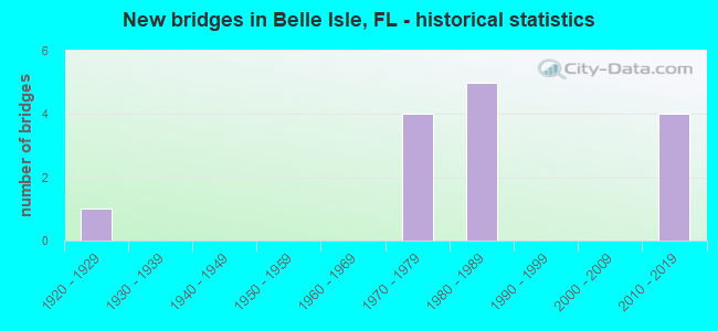
- New bridges - historical statistics
- 11920-1929
- 41970-1979
- 51980-1989
- 42010-2019
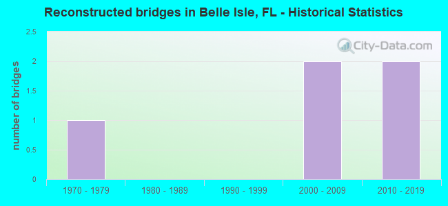
- Reconstructed bridges - Historical Statistics
- 11970-1979
- 01980-1989
- 01990-1999
- 22000-2009
- 22010-2019
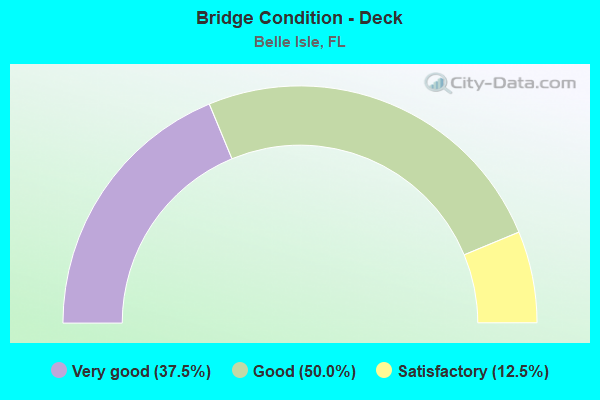
- Bridge Condition - Deck
- 37.5%Very good
- 50.0%Good
- 12.5%Satisfactory

- Bridge Condition - Superstructure
- 25.0%Very good
- 62.5%Good
- 12.5%Satisfactory
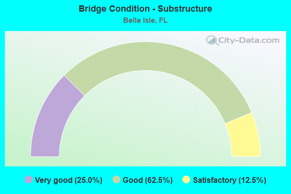
- Bridge Condition - Substructure
- 25.0%Very good
- 62.5%Good
- 12.5%Satisfactory
Find on map >> Show street view
Structure Number: 750099, Location: 8.1 MI E OF I-4 SR 400 (Lat: 28.450497, Lng: -81.351078), Route carried "on" structure: State highway 528, Year Built: 1973, Year Reconstructed: 2009, Status: Open, Structure Length: 6.32m (20.73ft), Average Daily Traffic: 42,350 (year 2020), Truck Traffic: 12%, Average Future Daily Traffic: 73,477 (year 2042), Design Load: HS 20, Features Intersected: SR 482 MCCOY RD
Minimum Vertical Clearance: 30+ m (98+ ft), Kilometerpoint: 13.060, Lanes on structure: 4, Lanes under structure: 5, Base Highway Network: Yes, Toll: On toll road, Owner: State Toll Authority, Approaching Roadway Width: 21.9m (71.9ft), Skew: 4 degrees, Material/Design: Prestressed concrete, Design/Construction: Stringer/Multi-beam, Number Of Spans In Main Unit: 3, Length of Maximum Span: 24.8m (81.4ft), Curb-To-Curb Width: 21.9m (71.9ft), Out-to-Out Width: 22.3m (73.2ft)
Condition: Deck: Good, Superstructure: Good, Substructure: Good, Operating Rating: 54.2 metric tons, Method Used To Determine Operating Rating: Load Factor (LF), Inventory Rating: 33.6 metric tons, Method Used To Determine Inventory Rating: Load Factor (LF), Structural Evaluation: Better than present minimum criteria, Deck Geometry: Better than present minimum criteria, Underclear: High priority of corrective action, Approach Roadway Alignment: Equal to present desirable criteria, Designated Inspection Frequency: Every 24 months, Inspection Date: November 2021, Deck Structure Type: Concrete Cast-file-Place
Find on map >> Show street view
Structure Number: 750225, Location: 8.1 MI EAST OF I-4 (Lat: 28.450383, Lng: -81.350761), Route carried "on" structure: State highway 528, Year Built: 1973, Year Reconstructed: 2009, Status: Open, Structure Length: 6.32m (20.73ft), Average Daily Traffic: 42,350 (year 2020), Truck Traffic: 12%, Average Future Daily Traffic: 73,477 (year 2042), Design Load: HS 20, Features Intersected: SR 482 MCCOY RD
Minimum Vertical Clearance: 30+ m (98+ ft), Kilometerpoint: 13.089, Lanes on structure: 3, Lanes under structure: 5, Base Highway Network: Yes, Toll: On toll road, Owner: State Toll Authority, Approaching Roadway Width: 21.9m (71.9ft), Skew: 4 degrees, Material/Design: Prestressed concrete, Design/Construction: Stringer/Multi-beam, Number Of Spans In Main Unit: 3, Length of Maximum Span: 24.7m (81.0ft), Curb-To-Curb Width: 21.9m (71.9ft), Out-to-Out Width: 22.9m (75.1ft)
Condition: Deck: Good, Superstructure: Good, Substructure: Good, Operating Rating: 54.0 metric tons, Method Used To Determine Operating Rating: Load Factor (LF), Inventory Rating: 33.4 metric tons, Method Used To Determine Inventory Rating: Load Factor (LF), Structural Evaluation: Better than present minimum criteria, Deck Geometry: Superior to present desirable criteria, Underclear: High priority of corrective action, Approach Roadway Alignment: Equal to present desirable criteria, Designated Inspection Frequency: Every 24 months, Inspection Date: November 2021, Deck Structure Type: Concrete Cast-file-Place
Find on map >> Show street view
Structure Number: 750318, Location: 4.6 Mi East of FL TPK (Lat: 28.450736, Lng: -81.345094), Route carried "on" structure: State highway 528, Year Built: 1982, Year Reconstructed: 2015, Status: Open, Structure Length: 4.82m (15.81ft), Average Daily Traffic: 103,500 (year 2020), Truck Traffic: 4%, Average Future Daily Traffic: 179,572 (year 2042), Design Load: HL 93, Features Intersected: Via Flora Drive
Minimum Vertical Clearance: 30+ m (98+ ft), Kilometerpoint: 12.902, Lanes on structure: 6, Lanes under structure: 3, Base Highway Network: Yes, Toll: On toll road, Owner: State Toll Authority, Approaching Roadway Width: 42.7m (140.1ft), Skew: 30 degrees, Material/Design: Prestressed concrete, Design/Construction: Stringer/Multi-beam, Number Of Spans In Main Unit: 3, Length of Maximum Span: 25.4m (83.3ft), Curb-To-Curb Width: 42.7m (140.1ft), Out-to-Out Width: 44.2m (145.0ft)
Condition: Deck: Good, Superstructure: Good, Substructure: Good, Operating Rating: 57.5 metric tons, Method Used To Determine Operating Rating: Load and Resistance Factor (LRFR), Inventory Rating: 44.5 metric tons, Method Used To Determine Inventory Rating: Load and Resistance Factor (LRFR), Structural Evaluation: Better than present minimum criteria, Deck Geometry: Superior to present desirable criteria, Underclear: Superior to present desirable criteria, Approach Roadway Alignment: Equal to present desirable criteria, Designated Inspection Frequency: Every 24 months, Inspection Date: August 2020, Deck Structure Type: Concrete Cast-file-Place
Find on map >> Show street view
Structure Number: 750319, Location: SR-528 over Daetwyler Dr (Lat: 28.450731, Lng: -81.338853), Route carried "on" structure: State highway 528, Year Built: 1982, Year Reconstructed: 2015, Status: Open, Structure Length: 4.71m (15.45ft), Average Daily Traffic: 103,500 (year 2020), Truck Traffic: 4%, Average Future Daily Traffic: 179,572 (year 2042), Design Load: HS 20, Features Intersected: Daetwyler Drive
Minimum Vertical Clearance: 30+ m (98+ ft), Kilometerpoint: 13.523, Lanes on structure: 9, Lanes under structure: 3, Base Highway Network: Yes, Toll: On toll road, Owner: State Toll Authority, Approaching Roadway Width: 50.3m (165.0ft), Skew: 30 degrees, Material/Design: Prestressed concrete, Design/Construction: Stringer/Multi-beam, Number Of Spans In Main Unit: 3, Length of Maximum Span: 25.3m (83.0ft), Curb-To-Curb Width: 50.3m (165.0ft), Out-to-Out Width: 55.3m (181.4ft)
Condition: Deck: Very good, Superstructure: Good, Substructure: Good, Operating Rating: 40.2 metric tons, Method Used To Determine Operating Rating: Load and Resistance Factor (LRFR), Inventory Rating: 35.6 metric tons, Method Used To Determine Inventory Rating: Load and Resistance Factor (LRFR), Structural Evaluation: Better than present minimum criteria, Deck Geometry: Superior to present desirable criteria, Underclear: Equal to present minimum criteria, Approach Roadway Alignment: Equal to present desirable criteria, Designated Inspection Frequency: Every 24 months, Inspection Date: July 2020, Deck Structure Type: Concrete Cast-file-Place
Find on map >> Show street view
Structure Number: 750829, Location: SR528 Ramp over Via Flora (Lat: 28.450528, Lng: -81.345167), Route carried "on" structure: Ramp State highway 528, Year Built: 2015, Status: Open, Structure Length: 2.79m (9.15ft), Average Daily Traffic: 11,000 (year 2020), Truck Traffic: 7%, Average Future Daily Traffic: 19,085 (year 2042), Design Load: HL 93, Features Intersected: Via Flora Drive
Minimum Vertical Clearance: 30+ m (98+ ft), Kilometerpoint: 0.315, Lanes on structure: 1, Lanes under structure: 2, Toll: On toll road, Owner: State Toll Authority, Approaching Roadway Width: 8.2m (26.9ft), Material/Design: Prestressed concrete, Design/Construction: Stringer/Multi-beam, Number Of Spans In Main Unit: 1, Length of Maximum Span: 27.3m (89.6ft), Curb-To-Curb Width: 8.2m (26.9ft), Out-to-Out Width: 9.2m (30.2ft)
Condition: Deck: Very good, Superstructure: Very good, Substructure: Very good, Operating Rating: 46.7 metric tons, Method Used To Determine Operating Rating: Load and Resistance Factor (LRFR), Inventory Rating: 43.1 metric tons, Method Used To Determine Inventory Rating: Load and Resistance Factor (LRFR), Structural Evaluation: Equal to present desirable criteria, Deck Geometry: Superior to present desirable criteria, Underclear: Superior to present desirable criteria, Approach Roadway Alignment: Equal to present desirable criteria, Designated Inspection Frequency: Every 24 months, Inspection Date: May 2020, Deck Structure Type: Concrete Cast-file-Place
Find on map >> Show street view
Structure Number: 75083, Location: SR528 Ramp over Via Flora (Lat: 28.451028, Lng: -81.345056), Route carried "on" structure: Ramp State highway 528, Year Built: 2015, Status: Open, Structure Length: 3.96m (12.99ft), Average Daily Traffic: 4,200 (year 2020), Truck Traffic: 6%, Average Future Daily Traffic: 7,287 (year 2042), Design Load: HL 93, Features Intersected: Via Flora Drive
Minimum Vertical Clearance: 30+ m (98+ ft), Kilometerpoint: 0.443, Lanes on structure: 1, Lanes under structure: 3, Toll: On toll road, Owner: State Toll Authority, Approaching Roadway Width: 8.8m (28.9ft), Material/Design: Prestressed concrete, Design/Construction: Stringer/Multi-beam, Number Of Spans In Main Unit: 1, Length of Maximum Span: 39.0m (128.0ft), Curb-To-Curb Width: 8.2m (26.9ft), Out-to-Out Width: 9.2m (30.2ft)
Condition: Deck: Very good, Superstructure: Very good, Substructure: Very good, Operating Rating: 37.9 metric tons, Method Used To Determine Operating Rating: Load and Resistance Factor (LRFR), Inventory Rating: 33.7 metric tons, Method Used To Determine Inventory Rating: Load and Resistance Factor (LRFR), Structural Evaluation: Equal to present desirable criteria, Deck Geometry: Superior to present desirable criteria, Underclear: Better than present minimum criteria, Approach Roadway Alignment: Equal to present desirable criteria, Designated Inspection Frequency: Every 24 months, Inspection Date: May 2020, Deck Structure Type: Concrete Cast-file-Place
Find on map >> Show street view
Structure Number: 754068, Location: 1.2 mi W of Conway Rd (Lat: 28.484442, Lng: -81.349603), Route carried "on" structure: County highway 506, Year Built: 1981, Status: Open, Structure Length: 1.10m (3.61ft), Average Daily Traffic: 17,700 (year 2021), Truck Traffic: 5%, Average Future Daily Traffic: 30,710 (year 2042), Design Load: HS 20, Features Intersected: Lake Conway Connector, Facility Carried by Structure: Hoffner Avenue
Minimum Vertical Clearance: 30+ m (98+ ft), Kilometerpoint: 5.406, Lanes on structure: 2, Owner: County Highway Agency, Approaching Roadway Width: 7.3m (24.0ft), Material/Design: Prestressed concrete, Design/Construction: Slab, Number Of Spans In Main Unit: 1, Length of Maximum Span: 11.0m (36.1ft), Curb or Sidewalk Widths: Left: 0.0m, Right: 1.8m (5.9ft), Curb-To-Curb Width: 9.5m (31.2ft), Out-to-Out Width: 12.3m (40.4ft)
Condition: Deck: Good, Superstructure: Good, Substructure: Good, Channel: Good, Operating Rating: 79.2 metric tons, Method Used To Determine Operating Rating: Allowable Stress (AS), Inventory Rating: 63.3 metric tons, Method Used To Determine Inventory Rating: Allowable Stress (AS), Structural Evaluation: Better than present minimum criteria, Deck Geometry: High priority of corrective action, Waterway Adequacy: Equal to present desirable criteria, Approach Roadway Alignment: Better than present minimum criteria, Designated Inspection Frequency: Every 24 months, Underwater Inspection Frequency: Every 24 months, Inspection Date: October 2021, Underwater Inspection Date: October 2021, Deck Structure Type: Concrete Precast Panels, Wearing Surface/Protective System: Wearing Surface: Bituminous
Find on map >> Show street view
Structure Number: 7551, Location: 0.6 Mi E of CR-527 (Lat: 28.464044, Lng: -81.357569), Route carried "on" structure: City street , Year Built: 1926, Year Reconstructed: 1982, Status: Posted for load, Structure Length: 4.54m (14.90ft), Average Daily Traffic: 1,950 (year 2021), Truck Traffic: 6%, Average Future Daily Traffic: 3,383 (year 2042), Design Load: H 15, Features Intersected: Lake Conway Connector, Facility Carried by Structure: Nela Avenue
Minimum Vertical Clearance: 30+ m (98+ ft), Kilometerpoint: 0.943, Lanes on structure: 2, Owner: City or Municipal Highway Agency, Approaching Roadway Width: 5.5m (18.0ft), Material/Design: Concrete continuous, Design/Construction: Tee Beam, Number Of Spans In Main Unit: 5, Length of Maximum Span: 11.4m (37.4ft), Curb or Sidewalk Widths: Left: 0.2m (0.7ft), Right: 1.2m (3.9ft), Curb-To-Curb Width: 5.5m (18.0ft), Out-to-Out Width: 7.5m (24.6ft)
Condition: Deck: Satisfactory, Superstructure: Satisfactory, Substructure: Satisfactory, Channel: Good, Operating Rating: 42.7 metric tons, Method Used To Determine Operating Rating: Load Factor (LF), Inventory Rating: 25.7 metric tons, Method Used To Determine Inventory Rating: Load Factor (LF), Structural Evaluation: Equal to present minimum criteria, Deck Geometry: High priority of replacement, Waterway Adequacy: Equal to present desirable criteria, Approach Roadway Alignment: Better than present minimum criteria, Designated Inspection Frequency: Every 24 months, Underwater Inspection Frequency: Every 24 months, Inspection Date: September 2021, Underwater Inspection Date: September 2021, Deck Structure Type: Concrete Cast-file-Place, Wearing Surface/Protective System: Wearing Surface: Bituminous
Find on map >> Show street view
Structure Number: 750099, Location: 8.1 MI E OF I-4 SR 400 (Lat: 28.450497, Lng: -81.351078), Route carried "under" structure: State highway 482, Year Built: 1973, Structure Length: 0. m, Average Daily Traffic: 39,500 (year 2020), Truck Traffic: 5%, Features Intersected: SR 482 MCCOY RD, Facility Carried by Structure: SR 528 WB 8.2
Minimum Vertical Clearance: 5.72m (18.77ft), Kilometerpoint: 12.316, Lanes on structure: 4, Lanes under structure: 5, Material/Design: Prestressed concrete, Design/Construction: Stringer/Multi-beam, Length of Maximum Span: 24.8m (81.4ft)
Find on map >> Show street view
Structure Number: 750225, Location: 8.1 MI EAST OF I-4 (Lat: 28.450383, Lng: -81.350761), Route carried "under" structure: State highway 482, Year Built: 1973, Structure Length: 0. m, Average Daily Traffic: 39,500 (year 2020), Truck Traffic: 5%, Features Intersected: SR 482 MCCOY RD, Facility Carried by Structure: SR 528 EB 8.2
Minimum Vertical Clearance: 5.08m (16.67ft), Kilometerpoint: 12.348, Lanes on structure: 3, Lanes under structure: 5, Material/Design: Prestressed concrete, Design/Construction: Stringer/Multi-beam, Length of Maximum Span: 24.7m (81.0ft)
Find on map >> Show street view
Structure Number: 750318, Location: 4.6 Mi East of FL TPK (Lat: 28.450736, Lng: -81.345094), Route carried "under" structure: City street , Year Built: 1982, Structure Length: 0. m, Average Daily Traffic: 9,400 (year 2019), Truck Traffic: 4%, Features Intersected: Via Flora Drive, Facility Carried by Structure: SR-528
Minimum Vertical Clearance: 5.39m (17.68ft), Kilometerpoint: 0.317, Lanes on structure: 6, Lanes under structure: 3, Material/Design: Prestressed concrete, Design/Construction: Stringer/Multi-beam, Length of Maximum Span: 25.4m (83.3ft)
Find on map >> Show street view
Structure Number: 750319, Location: SR-528 over Daetwyler Dr (Lat: 28.450731, Lng: -81.338853), Route carried "under" structure: County highway , Year Built: 1982, Structure Length: 0. m, Average Daily Traffic: 26,000 (year 2019), Truck Traffic: 5%, Features Intersected: Daetwyler Drive, Facility Carried by Structure: SR-528
Minimum Vertical Clearance: 5.15m (16.90ft), Kilometerpoint: 0.000, Lanes on structure: 9, Lanes under structure: 3, Material/Design: Prestressed concrete, Design/Construction: Stringer/Multi-beam, Length of Maximum Span: 25.3m (83.0ft)
Find on map >> Show street view
Structure Number: 750829, Location: SR528 Ramp over Via Flora (Lat: 28.450528, Lng: -81.345167), Route carried "under" structure: City street , Year Built: 2015, Structure Length: 0. m, Average Daily Traffic: 4,000 (year 2020), Truck Traffic: 5%, Features Intersected: Via Flora Drive, Facility Carried by Structure: SR-528 Ramp BC-1
Minimum Vertical Clearance: 5.64m (18.50ft), Kilometerpoint: 0.000, Lanes on structure: 1, Lanes under structure: 2, Material/Design: Prestressed concrete, Design/Construction: Stringer/Multi-beam, Length of Maximum Span: 27.3m (89.6ft)
Find on map >> Show street view
Structure Number: 75083, Location: SR528 Ramp over Via Flora (Lat: 28.451028, Lng: -81.345056), Route carried "under" structure: City street , Year Built: 2015, Structure Length: 0. m, Average Daily Traffic: 4,000 (year 2020), Truck Traffic: 5%, Features Intersected: Via Flora Drive, Facility Carried by Structure: SR-528 Ramp BC-2
Minimum Vertical Clearance: 5.03m (16.50ft), Kilometerpoint: 0.000, Lanes on structure: 1, Lanes under structure: 3, Material/Design: Prestressed concrete, Design/Construction: Stringer/Multi-beam, Length of Maximum Span: 39.0m (128.0ft)