Bridge Statistics for Benton Harbor, Michigan (MI)
Condition, Traffic, Stress, Structural Evaluation, Project Costs
- National Bridge Inventory (NBI) Statistics
- 12Number of bridges
- 115ft / 35.3mTotal length
- $177,000Total costs
- 55,032Total average daily traffic
- 2,664Total average daily truck traffic
- National Bridge Inventory (NBI) Registered Bridges for Benton Harbor
- No street view available for this location
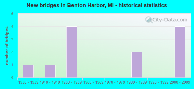
- New bridges - historical statistics
- 11930-1939
- 11940-1949
- 41950-1959
- 21980-1989
- 42000-2009
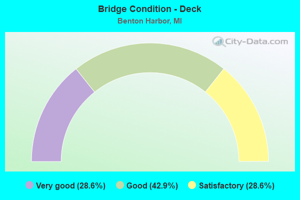
- Bridge Condition - Deck
- 28.6%Very good
- 42.9%Good
- 28.6%Satisfactory
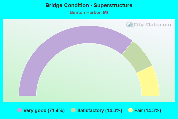
- Bridge Condition - Superstructure
- 71.4%Very good
- 14.3%Satisfactory
- 14.3%Fair
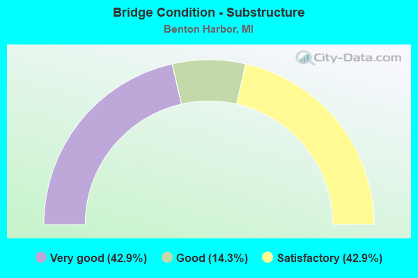
- Bridge Condition - Substructure
- 42.9%Very good
- 14.3%Good
- 42.9%Satisfactory
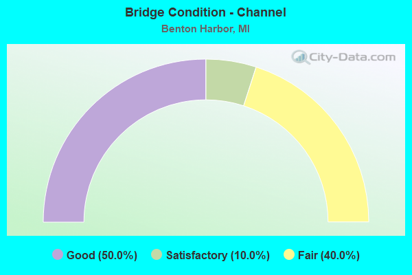
- Bridge Condition - Channel
- 50.0%Good
- 10.0%Satisfactory
- 40.0%Fair
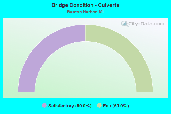
- Bridge Condition - Culverts
- 50.0%Satisfactory
- 50.0%Fair
Find on map >> Show street view
Structure Number: 776, Location: 0.1 MI W OF PAW PAW AVE (Lat: 42.117397, Lng: -86.449342), Route carried "on" structure: Business Interstate 94, Year Built: 1950, Status: Open, Structure Length: 0.88m (2.89ft), Average Daily Traffic: 8,317 (year 2007), Truck Traffic: 4%, Average Future Daily Traffic: 9,724 (year 2018), Design Load: HS 20, Features Intersected: OX CREEK
Minimum Vertical Clearance: 30.48m (100.00ft), Kilometerpoint: 3.055, Lanes on structure: 2, Base Highway Network: Yes (Inventory Route: 136, Subroute: 3), Owner: State Highway Agency, Approaching Roadway Width: 14.1m (46.3ft), Skew: 22 degrees, Material/Design: Concrete, Design/Construction: Culvert, Number Of Spans In Main Unit: 2, Length of Maximum Span: 4.2m (13.8ft), Curb or Sidewalk Widths: Left: 8.1m (26.6ft), Right: 7.7m (25.3ft), Curb-To-Curb Width: 11.6m (38.1ft), Out-to-Out Width: 29.0m (95.1ft)
Condition: Channel: Fair, Culverts: Satisfactory, Operating Rating: 54.1 metric tons, Method Used To Determine Operating Rating: Field evaluation and documented engineering judgment, Inventory Rating: 32.4 metric tons, Method Used To Determine Inventory Rating: Field evaluation and documented engineering judgment, Structural Evaluation: Equal to present minimum criteria, Deck Geometry: Somewhat better than minimum adequacy, Waterway Adequacy: Better than present minimum criteria, Approach Roadway Alignment: Equal to present desirable criteria, Designated Inspection Frequency: Every 24 months, Inspection Date: March 2022, Deck Structure Type: Concrete Cast-file-Place, Wearing Surface/Protective System: Wearing Surface: Low Slump Concrete
Find on map >> Show street view
Structure Number: 885, Location: 1.0 MI N OF BENTON HARBOR (Lat: 42.126514, Lng: -86.464761), Route carried "on" structure: State highway 63, Year Built: 1954, Year Reconstructed: 2008, Status: Open, Structure Length: 4.79m (15.72ft), Average Daily Traffic: 8,650 (year 2008), Truck Traffic: 8%, Average Future Daily Traffic: 10,600 (year 2028), Design Load: HL 93, Features Intersected: HIGMAN PARK ROAD
Minimum Vertical Clearance: 30.48m (100.00ft), Kilometerpoint: 12.091, Lanes on structure: 4, Lanes under structure: 2, Base Highway Network: Yes (Inventory Route: 136, Subroute: 5), Owner: State Highway Agency, Approaching Roadway Width: 20.8m (68.2ft), Skew: 4 degrees, Material/Design: Steel, Design/Construction: Stringer/Multi-beam, Number Of Spans In Main Unit: 3, Length of Maximum Span: 19.2m (63.0ft), Curb-To-Curb Width: 21.1m (69.2ft), Out-to-Out Width: 21.8m (71.5ft)
Condition: Deck: Good, Superstructure: Fair, Substructure: Satisfactory, Operating Rating: 80.4 metric tons, Method Used To Determine Operating Rating: Load Factor (LF) rating reported by rating factor (RF) method using MS18 loading, Inventory Rating: 48.0 metric tons, Method Used To Determine Inventory Rating: Load Factor (LF) rating reported by rating factor (RF) method using MS18 loading, Structural Evaluation: Somewhat better than minimum adequacy, Deck Geometry: Superior to present desirable criteria, Underclear: Somewhat better than minimum adequacy, Approach Roadway Alignment: Equal to present desirable criteria, Designated Inspection Frequency: Every 24 months, Inspection Date: June 2020, Deck Structure Type: Concrete Cast-file-Place, Wearing Surface/Protective System: Wearing Surface: Epoxy Overlay, Deck Protection: Epoxy Coated Reinforcing
Find on map >> Show street view
Structure Number: 1047, Location: 1 BLK E OF PIPESTONE RD (Lat: 42.101569, Lng: -86.438789), Route carried "on" structure: City street 2013, Year Built: 1984, Status: Open, Structure Length: 0.79m (2.59ft), Average Daily Traffic: 4,000 (year 1984), Truck Traffic: 1%, Average Future Daily Traffic: 4,500 (year 2011), Design Load: HS 20, Features Intersected: OX CREEK, Facility Carried by Structure: EMPIRE AVENUE
Minimum Vertical Clearance: 30.48m (100.00ft), Kilometerpoint: 2.210, Lanes on structure: 2, Owner: City or Municipal Highway Agency, Approaching Roadway Width: 12.5m (41.0ft), Skew: 3 degrees, Material/Design: Prestressed concrete, Design/Construction: Box Beam or Girders - Multiple, Number Of Spans In Main Unit: 1, Length of Maximum Span: 7.3m (24.0ft), Curb or Sidewalk Widths: Left: 0.0m, Right: 1.3m (4.3ft), Curb-To-Curb Width: 8.2m (26.9ft), Out-to-Out Width: 10.5m (34.4ft)
Condition: Deck: Satisfactory, Superstructure: Satisfactory, Substructure: Satisfactory, Channel: Fair, Operating Rating: 66.4 metric tons, Method Used To Determine Operating Rating: Load Factor (LF) rating reported by rating factor (RF) method using MS18 loading, Inventory Rating: 39.9 metric tons, Method Used To Determine Inventory Rating: Load Factor (LF) rating reported by rating factor (RF) method using MS18 loading, Structural Evaluation: Equal to present minimum criteria, Deck Geometry: High priority of corrective action, Waterway Adequacy: Better than present minimum criteria, Approach Roadway Alignment: Somewhat better than minimum adequacy, Designated Inspection Frequency: Every 24 months, Inspection Date: October 2021, Deck Structure Type: Other, Wearing Surface/Protective System: Wearing Surface: Bituminous, Membrane: Preformed Fabric
Find on map >> Show street view
Structure Number: 1048, Location: 3 BLKS E OF PIPESTONE RD (Lat: 42.108922, Lng: -86.443153), Route carried "on" structure: City street 2013, Year Built: 2004, Status: Open, Structure Length: 10.73m (35.20ft), Average Daily Traffic: 2,545 (year 2000), Truck Traffic: 2%, Average Future Daily Traffic: 4,600 (year 2020), Design Load: HS 20, Features Intersected: C&O RR (ABAN) & OX CREEK, Facility Carried by Structure: BRITAIN AVENUE
Minimum Vertical Clearance: 30.48m (100.00ft), Kilometerpoint: 1.764, Lanes on structure: 4, Owner: City or Municipal Highway Agency, Approaching Roadway Width: 15.9m (52.2ft), Skew: 2 degrees, Material/Design: Prestressed concrete, Design/Construction: Stringer/Multi-beam, Number Of Spans In Main Unit: 6, Length of Maximum Span: 21.6m (70.9ft), Curb or Sidewalk Widths: Left: 1.5m (4.9ft), Right: 1.5m (4.9ft), Curb-To-Curb Width: 12.8m (42.0ft), Out-to-Out Width: 16.7m (54.8ft)
Condition: Deck: Good, Superstructure: Very good, Substructure: Satisfactory, Channel: Good, Operating Rating: 57.0 metric tons, Method Used To Determine Operating Rating: Load Factor (LF) rating reported by rating factor (RF) method using MS18 loading, Inventory Rating: 44.1 metric tons, Method Used To Determine Inventory Rating: Load Factor (LF) rating reported by rating factor (RF) method using MS18 loading, Structural Evaluation: Equal to present minimum criteria, Deck Geometry: High priority of replacement, Waterway Adequacy: Superior to present desirable criteria, Approach Roadway Alignment: Equal to present desirable criteria, Designated Inspection Frequency: Every 24 months, Inspection Date: October 2021, Deck Structure Type: Concrete Cast-file-Place, Wearing Surface/Protective System: Wearing Surface: Monolithic Concrete, Deck Protection: Epoxy Coated Reinforcing
Find on map >> Show street view
Structure Number: 1049, Location: 1 BLK W OF PAW PAW AVE (Lat: 42.116125, Lng: -86.448161), Route carried "on" structure: City street 2013, Year Built: 1953, Status: Open, Structure Length: 0.85m (2.79ft), Average Daily Traffic: 3,000 (year 1989), Truck Traffic: 1%, Average Future Daily Traffic: 3,000 (year 2011), Design Load: H 20, Features Intersected: OX CREEK, Facility Carried by Structure: HIGHLAND AVENUE
Minimum Vertical Clearance: 30.48m (100.00ft), Kilometerpoint: 1.069, Lanes on structure: 4, Owner: City or Municipal Highway Agency, Approaching Roadway Width: 17.4m (57.1ft), Skew: 2 degrees, Material/Design: Concrete continuous, Design/Construction: Culvert, Number Of Spans In Main Unit: 2, Length of Maximum Span: 3.6m (11.8ft), Curb or Sidewalk Widths: Left: 1.8m (5.9ft), Right: 1.8m (5.9ft), Curb-To-Curb Width: 13.4m (44.0ft), Out-to-Out Width: 17.8m (58.4ft)
Condition: Channel: Fair, Culverts: Fair, Operating Rating: 53.5 metric tons, Method Used To Determine Operating Rating: Load Factor (LF) rating reported by rating factor (RF) method using MS18 loading, Inventory Rating: 32.1 metric tons, Method Used To Determine Inventory Rating: Load Factor (LF) rating reported by rating factor (RF) method using MS18 loading, Structural Evaluation: Somewhat better than minimum adequacy, Deck Geometry: High priority of replacement, Waterway Adequacy: Better than present minimum criteria, Approach Roadway Alignment: Equal to present desirable criteria, Length Of Structure Improvement: 0.85m (2.79ft), Designated Inspection Frequency: Every 24 months, Inspection Date: October 2021, Bridge Improvement Cost: $17,000, Total Project Cost: $17,000, Deck Structure Type: Concrete Cast-file-Place, Wearing Surface/Protective System: Wearing Surface: Monolithic Concrete
Find on map >> Show street view
Structure Number: 105, Location: 2 BLKS W OF PAW PAW AVE (Lat: 42.118158, Lng: -86.449919), Route carried "on" structure: City street 2013, Year Built: 1949, Status: Open, Structure Length: 0.70m (2.30ft), Average Daily Traffic: 6,000 (year 1991), Truck Traffic: 1%, Average Future Daily Traffic: 6,500 (year 2011), Design Load: H 20, Features Intersected: OX CREEK, Facility Carried by Structure: TERRITORIAL ROAD
Minimum Vertical Clearance: 30.48m (100.00ft), Kilometerpoint: 1.196, Lanes on structure: 4, Owner: City or Municipal Highway Agency, Approaching Roadway Width: 16.5m (54.1ft), Material/Design: Concrete, Design/Construction: Culvert, Number Of Spans In Main Unit: 2, Length of Maximum Span: 3.3m (10.8ft), Curb or Sidewalk Widths: Left: 3.6m (11.8ft), Right: 3.6m (11.8ft), Curb-To-Curb Width: 16.5m (54.1ft), Out-to-Out Width: 24.7m (81.0ft)
Condition: Channel: Satisfactory, Culverts: Fair, Operating Rating: 40.5 metric tons, Method Used To Determine Operating Rating: Load Factor (LF) rating reported by rating factor (RF) method using MS18 loading, Inventory Rating: 24.3 metric tons, Method Used To Determine Inventory Rating: Load Factor (LF) rating reported by rating factor (RF) method using MS18 loading, Structural Evaluation: Somewhat better than minimum adequacy, Deck Geometry: Meets minimum limits, Waterway Adequacy: Equal to present desirable criteria, Approach Roadway Alignment: Equal to present desirable criteria, Length Of Structure Improvement: 0.70m (2.30ft), Designated Inspection Frequency: Every 24 months, Inspection Date: October 2021, Bridge Improvement Cost: $10,000, Total Project Cost: $10,000, Deck Structure Type: Concrete Cast-file-Place, Wearing Surface/Protective System: Wearing Surface: Monolithic Concrete
Find on map >> Show street view
Structure Number: 1052, Location: 5 BLKS N OF MAIN ST (Lat: 42.121100, Lng: -86.454475), Route carried "on" structure: City street 2013, Year Built: 1939, Status: Open, Structure Length: 0.76m (2.49ft), Average Daily Traffic: 3,900 (year 1984), Truck Traffic: 4%, Average Future Daily Traffic: 5,000 (year 2011), Design Load: H 20, Features Intersected: OX CREEK, Facility Carried by Structure: NORTH SHORE DRIVE
Minimum Vertical Clearance: 30.48m (100.00ft), Kilometerpoint: 1.751, Lanes on structure: 2, Owner: City or Municipal Highway Agency, Approaching Roadway Width: 20.7m (67.9ft), Material/Design: Concrete continuous, Design/Construction: Culvert, Number Of Spans In Main Unit: 2, Number Of Approach Spans: 1, Length of Maximum Span: 2.7m (8.9ft), Curb or Sidewalk Widths: Left: 1.5m (4.9ft), Right: 1.5m (4.9ft), Curb-To-Curb Width: 11.0m (36.1ft), Out-to-Out Width: 20.8m (68.2ft)
Condition: Channel: Fair, Culverts: Satisfactory, Operating Rating: 42.7 metric tons, Method Used To Determine Operating Rating: Load Factor (LF), Inventory Rating: 26.4 metric tons, Method Used To Determine Inventory Rating: Load Factor (LF), Structural Evaluation: Equal to present minimum criteria, Deck Geometry: Somewhat better than minimum adequacy, Waterway Adequacy: Better than present minimum criteria, Approach Roadway Alignment: Equal to present desirable criteria, Length Of Structure Improvement: 0.91m (2.99ft), Designated Inspection Frequency: Every 24 months, Inspection Date: October 2021, Bridge Improvement Cost: $147,000, Total Project Cost: $150,000, Deck Structure Type: Concrete Cast-file-Place, Wearing Surface/Protective System: Wearing Surface: Bituminous
Find on map >> Show street view
Structure Number: 1053, Location: 7 BLKS N OF MAIN ST (Lat: 42.125131, Lng: -86.455011), Route carried "on" structure: County highway 2013, Year Built: 2006, Status: Open, Structure Length: 5.30m (17.39ft), Average Daily Traffic: 2,500 (year 2004), Truck Traffic: 6%, Average Future Daily Traffic: 3,500 (year 2024), Design Load: HS 20, Features Intersected: PAW PAW RIVER, Facility Carried by Structure: NORTH SHORE DRIVE
Minimum Vertical Clearance: 30.48m (100.00ft), Kilometerpoint: 2.253, Lanes on structure: 2, Owner: City or Municipal Highway Agency, Approaching Roadway Width: 14.6m (47.9ft), Skew: 3 degrees, Navigation Control: Yes ( Vertical Clearance: 0.3m (1.0ft), Horizontal Clearance: 17.1m (56.1ft)), Material/Design: Prestressed concrete, Design/Construction: Stringer/Multi-beam, Number Of Spans In Main Unit: 3, Length of Maximum Span: 17.7m (58.1ft), Curb-To-Curb Width: 12.2m (40.0ft), Out-to-Out Width: 16.0m (52.5ft)
Condition: Deck: Very good, Superstructure: Very good, Substructure: Very good, Channel: Good, Operating Rating: 55.4 metric tons, Method Used To Determine Operating Rating: Load Factor (LF) rating reported by rating factor (RF) method using MS18 loading, Inventory Rating: 31.4 metric tons, Method Used To Determine Inventory Rating: Load Factor (LF) rating reported by rating factor (RF) method using MS18 loading, Structural Evaluation: Better than present minimum criteria, Deck Geometry: Equal to present minimum criteria, Waterway Adequacy: Superior to present desirable criteria, Approach Roadway Alignment: Equal to present desirable criteria, Designated Inspection Frequency: Every 24 months, Underwater Inspection Frequency: Every 60 months, Inspection Date: October 2021, Underwater Inspection Date: November 2021, Deck Structure Type: Concrete Cast-file-Place, Wearing Surface/Protective System: Deck Protection: Epoxy Coated Reinforcing
Find on map >> Show street view
Structure Number: 1054, Location: 0.5 MI N TERRITORIAL RD (Lat: 42.125083, Lng: -86.448172), Route carried "on" structure: City street 2013, Year Built: 1989, Status: Open, Structure Length: 3.65m (11.98ft), Average Daily Traffic: 4,620 (year 1984), Truck Traffic: 4%, Average Future Daily Traffic: 6,000 (year 2011), Design Load: HS 20, Features Intersected: PAW PAW RIVER, Facility Carried by Structure: PAW PAW AVENUE
Minimum Vertical Clearance: 30.48m (100.00ft), Kilometerpoint: 1.030, Lanes on structure: 2, Owner: City or Municipal Highway Agency, Approaching Roadway Width: 12.2m (40.0ft), Navigation Control: Yes ( Vertical Clearance: 0.3m (1.0ft), Horizontal Clearance: 12.9m (42.3ft)), Material/Design: Prestressed concrete, Design/Construction: Stringer/Multi-beam, Number Of Spans In Main Unit: 3, Length of Maximum Span: 14.9m (48.9ft), Curb or Sidewalk Widths: Left: 1.5m (4.9ft), Right: 1.5m (4.9ft), Curb-To-Curb Width: 9.1m (29.9ft), Out-to-Out Width: 12.9m (42.3ft)
Condition: Deck: Satisfactory, Superstructure: Very good, Substructure: Good, Channel: Good, Operating Rating: 55.4 metric tons, Method Used To Determine Operating Rating: Load Factor (LF) rating reported by rating factor (RF) method using MS18 loading, Inventory Rating: 33.4 metric tons, Method Used To Determine Inventory Rating: Load Factor (LF) rating reported by rating factor (RF) method using MS18 loading, Structural Evaluation: Better than present minimum criteria, Deck Geometry: Meets minimum limits, Waterway Adequacy: Superior to present desirable criteria, Approach Roadway Alignment: Equal to present desirable criteria, Designated Inspection Frequency: Every 24 months, Underwater Inspection Frequency: Every 60 months, Inspection Date: October 2021, Underwater Inspection Date: November 2021, Deck Structure Type: Concrete Cast-file-Place, Wearing Surface/Protective System: Wearing Surface: Bituminous, Deck Protection: Epoxy Coated Reinforcing
Find on map >> Show street view
Structure Number: 13181, Location: 1 BLK S OF KLOCK RD (Lat: 42.120506, Lng: -86.460158), Route carried "on" structure: City street , Year Built: 2002, Status: Open, Structure Length: 2.13m (6.99ft), Average Daily Traffic: 6,500 (year 2000), Truck Traffic: 10%, Average Future Daily Traffic: 8,000 (year 2010), Design Load: HS 20, Features Intersected: OX CREEK, Facility Carried by Structure: EIGHTH STREET
Minimum Vertical Clearance: 30.48m (100.00ft), Kilometerpoint: 0.233, Lanes on structure: 2, Owner: City or Municipal Highway Agency, Approaching Roadway Width: 10.4m (34.1ft), Material/Design: Prestressed concrete, Design/Construction: Box Beam or Girders - Multiple, Number Of Spans In Main Unit: 1, Length of Maximum Span: 20.7m (67.9ft), Curb-To-Curb Width: 10.7m (35.1ft), Out-to-Out Width: 11.4m (37.4ft)
Condition: Deck: Good, Superstructure: Very good, Substructure: Very good, Channel: Good, Operating Rating: 65.8 metric tons, Method Used To Determine Operating Rating: Load Factor (LF) rating reported by rating factor (RF) method using MS18 loading, Inventory Rating: 16.2 metric tons, Method Used To Determine Inventory Rating: Load Factor (LF) rating reported by rating factor (RF) method using MS18 loading, Structural Evaluation: Meets minimum limits, Deck Geometry: Meets minimum limits, Waterway Adequacy: Superior to present desirable criteria, Approach Roadway Alignment: Equal to present desirable criteria, Designated Inspection Frequency: Every 24 months, Inspection Date: October 2021, Deck Structure Type: Concrete Cast-file-Place, Wearing Surface/Protective System: Deck Protection: Epoxy Coated Reinforcing
Find on map >> Show street view
Structure Number: 13206, Location: BENTON HARBOR/ST JOSEPH (Lat: 42.116194, Lng: -86.468778), Route carried "on" structure: City street , Year Built: 2004, Status: Open, Structure Length: 4.75m (15.58ft), Average Daily Traffic: 4,000 (year 2004), Truck Traffic: 8%, Average Future Daily Traffic: 7,225 (year 2024), Features Intersected: PAW PAW RIVER, Facility Carried by Structure: EDGEWATER DRIVE
Minimum Vertical Clearance: 30.48m (100.00ft), Kilometerpoint: 0.922, Lanes on structure: 3, Owner: City or Municipal Highway Agency, Approaching Roadway Width: 12.2m (40.0ft), Material/Design: Prestressed concrete, Design/Construction: Stringer/Multi-beam, Number Of Spans In Main Unit: 1, Length of Maximum Span: 45.7m (149.9ft), Curb-To-Curb Width: 12.2m (40.0ft), Out-to-Out Width: 14.8m (48.6ft)
Condition: Deck: Very good, Superstructure: Very good, Substructure: Very good, Channel: Good, Operating Rating: 66.1 metric tons, Method Used To Determine Operating Rating: Load Factor (LF) rating reported by rating factor (RF) method using MS18 loading, Inventory Rating: 50.9 metric tons, Method Used To Determine Inventory Rating: Load Factor (LF) rating reported by rating factor (RF) method using MS18 loading, Structural Evaluation: Equal to present desirable criteria, Deck Geometry: Meets minimum limits, Waterway Adequacy: Equal to present desirable criteria, Approach Roadway Alignment: Equal to present desirable criteria, Designated Inspection Frequency: Every 24 months, Inspection Date: October 2021, Deck Structure Type: Concrete Cast-file-Place, Wearing Surface/Protective System: Wearing Surface: Monolithic Concrete, Deck Protection: Epoxy Coated Reinforcing
Find on map >> Show street view
Structure Number: 885, Location: 1.0 MI N OF BENTON HARBOR (Lat: 42.126514, Lng: -86.464761), Route carried "under" structure: County highway , Year Built: 1954, Structure Length: 0. m, Average Daily Traffic: 1,000 (year 0000), Features Intersected: HIGMAN PARK ROAD, Facility Carried by Structure: M-63
Minimum Vertical Clearance: 4.50m (14.76ft), Kilometerpoint: 0.626, Lanes on structure: 4, Lanes under structure: 2, Material/Design: Steel, Design/Construction: Stringer/Multi-beam, Length of Maximum Span: 19.2m (63.0ft)