Bridge Statistics for Beulah, Alabama (AL)
Condition, Traffic, Stress, Structural Evaluation, Project Costs
- National Bridge Inventory (NBI) Statistics
- 16Number of bridges
- 240ft / 73.1mTotal length
- $19,490,000Total costs
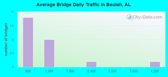
- 12,005Total average daily traffic
- 748Total average daily truck traffic
- 18,011Total future (year 2040) average daily traffic
- National Bridge Inventory (NBI) Registered Bridges for Beulah
- No street view available for this location
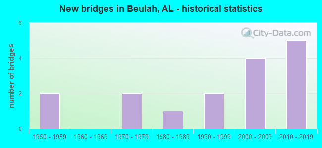
- New bridges - historical statistics
- 21950-1959
- 21970-1979
- 11980-1989
- 21990-1999
- 42000-2009
- 52010-2019
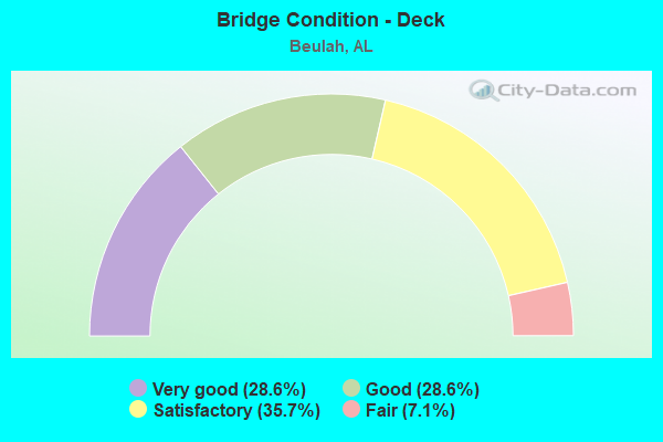
- Bridge Condition - Deck
- 28.6%Very good
- 28.6%Good
- 35.7%Satisfactory
- 7.1%Fair
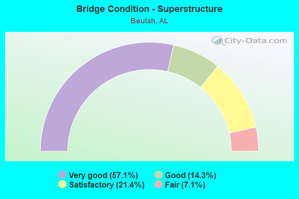
- Bridge Condition - Superstructure
- 57.1%Very good
- 14.3%Good
- 21.4%Satisfactory
- 7.1%Fair
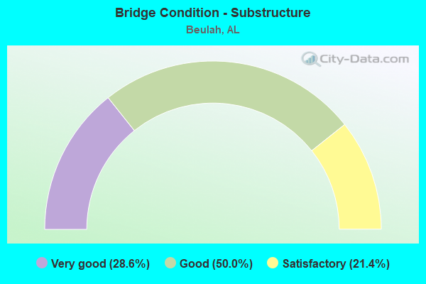
- Bridge Condition - Substructure
- 28.6%Very good
- 50.0%Good
- 21.4%Satisfactory
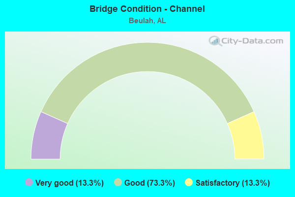
- Bridge Condition - Channel
- 13.3%Very good
- 73.3%Good
- 13.3%Satisfactory
Find on map >> Show street view
Structure Number: 475, Location: 1.6 MI W JCT LEE RD 145 (Lat: 32.589539, Lng: -85.286517), Route carried "on" structure: County highway 1148, Year Built: 1954, Status: Posted for load, Structure Length: 0.67m (2.20ft), Average Daily Traffic: 540 (year 2020), Truck Traffic: 1%, Average Future Daily Traffic: 810 (year 2040), Features Intersected: PHELPS CREEK, Facility Carried by Structure: Lee Road 148
Minimum Vertical Clearance: 30+ m (98+ ft), Kilometerpoint: 0.010, Lanes on structure: 2, Owner: County Highway Agency, Approaching Roadway Width: 8.5m (27.9ft), Skew: 1 degrees, Material/Design: Steel, Design/Construction: Stringer/Multi-beam, Number Of Spans In Main Unit: 1, Length of Maximum Span: 6.7m (22.0ft), Curb-To-Curb Width: 10.6m (34.8ft), Out-to-Out Width: 11.1m (36.4ft)
Condition: Deck: Satisfactory, Superstructure: Fair, Substructure: Good, Channel: Good, Operating Rating: 29.0 metric tons, Method Used To Determine Operating Rating: Allowable Stress (AS), Inventory Rating: 19.1 metric tons, Method Used To Determine Inventory Rating: Allowable Stress (AS), Structural Evaluation: Somewhat better than minimum adequacy, Deck Geometry: Equal to present minimum criteria, Waterway Adequacy: Better than present minimum criteria, Approach Roadway Alignment: Equal to present desirable criteria, Bridge Posting: Required (Relationship of Operating Rating to Maximum Legal Load: 30.0 - 39.9% below), Length Of Structure Improvement: 1.30m (4.27ft), Designated Inspection Frequency: Every 24 months, Other Special Inspection Frequency: Every 12 months, Inspection Date: October 2020, Other Special Inspection Date: October 2021, Bridge Improvement Cost: $321,000, Roadway Improvement Cost: $32,000, Total Project Cost: $353,000 ( Estimate for 2022), Deck Structure Type: Concrete Cast-file-Place
Find on map >> Show street view
Structure Number: 5262, Location: 0.5 MI S E JCT S 015 (Lat: 32.696331, Lng: -85.256019), Route carried "on" structure: County highway 1390, Year Built: 1955, Status: Posted for load, Structure Length: 4.33m (14.21ft), Average Daily Traffic: 833 (year 2020), Truck Traffic: 10%, Average Future Daily Traffic: 1,250 (year 2040), Features Intersected: HALAWAKEE CREEK, Facility Carried by Structure: Lee Road 390
Minimum Vertical Clearance: 30+ m (98+ ft), Kilometerpoint: 0.010, Lanes on structure: 2, Owner: County Highway Agency, Approaching Roadway Width: 7.3m (24.0ft), Skew: 3 degrees, Material/Design: Concrete, Design/Construction: Tee Beam, Number Of Spans In Main Unit: 4, Length of Maximum Span: 12.2m (40.0ft), Curb-To-Curb Width: 6.6m (21.7ft), Out-to-Out Width: 7.7m (25.3ft)
Condition: Deck: Satisfactory, Superstructure: Satisfactory, Substructure: Satisfactory, Channel: Satisfactory, Operating Rating: 30.2 metric tons, Method Used To Determine Operating Rating: Allowable Stress (AS), Inventory Rating: 16.3 metric tons, Method Used To Determine Inventory Rating: Allowable Stress (AS), Structural Evaluation: Meets minimum limits, Deck Geometry: High priority of corrective action, Waterway Adequacy: Better than present minimum criteria, Approach Roadway Alignment: Equal to present minimum criteria, Bridge Posting: Required (Relationship of Operating Rating to Maximum Legal Load: 20.0 - 29.9% below), Length Of Structure Improvement: 5.31m (17.42ft), Designated Inspection Frequency: Every 24 months, Other Special Inspection Frequency: Every 12 months, Inspection Date: December 2020, Other Special Inspection Date: December 2021, Bridge Improvement Cost: $910,000, Roadway Improvement Cost: $91,000, Total Project Cost: $1,001,000 ( Estimate for 2022), Deck Structure Type: Concrete Cast-file-Place
Find on map >> Show street view
Structure Number: 10582, Location: 0.5 MI S W JCT S 001 (Lat: 32.623189, Lng: -85.288675), Route carried "on" structure: County highway 1391, Year Built: 1971, Status: Open, Structure Length: 3.35m (10.99ft), Average Daily Traffic: 726 (year 2020), Truck Traffic: 11%, Average Future Daily Traffic: 1,089 (year 2040), Design Load: HS 20, Features Intersected: CENTRAL OF GA R R, Facility Carried by Structure: Lee Road 391
Minimum Vertical Clearance: 30+ m (98+ ft), Kilometerpoint: 0.010, Lanes on structure: 2, Owner: County Highway Agency, Approaching Roadway Width: 8.5m (27.9ft), Material/Design: Steel, Design/Construction: Stringer/Multi-beam, Number Of Spans In Main Unit: 1, Number Of Approach Spans: 2, Length of Maximum Span: 12.5m (41.0ft), Curb-To-Curb Width: 8.5m (27.9ft), Out-to-Out Width: 9.0m (29.5ft)
Condition: Deck: Fair, Superstructure: Satisfactory, Substructure: Satisfactory, Operating Rating: 50.0 metric tons, Method Used To Determine Operating Rating: Allowable Stress (AS), Inventory Rating: 29.3 metric tons, Method Used To Determine Inventory Rating: Allowable Stress (AS), Structural Evaluation: Equal to present minimum criteria, Deck Geometry: Somewhat better than minimum adequacy, Underclear: Somewhat better than minimum adequacy, Approach Roadway Alignment: Better than present minimum criteria, Length Of Structure Improvement: 4.24m (13.91ft), Designated Inspection Frequency: Every 24 months, Inspection Date: November 2020, Bridge Improvement Cost: $843,000, Roadway Improvement Cost: $84,000, Total Project Cost: $927,000 ( Estimate for 2022), Deck Structure Type: Concrete Cast-file-Place
Find on map >> Show street view
Structure Number: 12044, Location: 1.3 MI S E LEE RD 390 (Lat: 32.674419, Lng: -85.238947), Route carried "on" structure: County highway 1252, Year Built: 1978, Status: Posted for load, Structure Length: 0.91m (2.99ft), Average Daily Traffic: 191 (year 2020), Truck Traffic: 3%, Average Future Daily Traffic: 287 (year 2040), Features Intersected: HALAWAKEE BRANCH, Facility Carried by Structure: Lee Road 252
Minimum Vertical Clearance: 30+ m (98+ ft), Kilometerpoint: 0.010, Lanes on structure: 2, Owner: County Highway Agency, Approaching Roadway Width: 8.5m (27.9ft), Material/Design: Steel, Design/Construction: Stringer/Multi-beam, Number Of Spans In Main Unit: 1, Length of Maximum Span: 9.1m (29.9ft), Curb-To-Curb Width: 7.3m (24.0ft), Out-to-Out Width: 7.5m (24.6ft)
Condition: Deck: Satisfactory, Superstructure: Satisfactory, Substructure: Good, Channel: Good, Operating Rating: 43.8 metric tons, Method Used To Determine Operating Rating: Allowable Stress (AS), Inventory Rating: 29.0 metric tons, Method Used To Determine Inventory Rating: Allowable Stress (AS), Structural Evaluation: Equal to present minimum criteria, Deck Geometry: Somewhat better than minimum adequacy, Waterway Adequacy: Better than present minimum criteria, Approach Roadway Alignment: Equal to present minimum criteria, Bridge Posting: Required (Relationship of Operating Rating to Maximum Legal Load: 0.1 - 9.9% below), Length Of Structure Improvement: 1.58m (5.18ft), Designated Inspection Frequency: Every 24 months, Other Special Inspection Frequency: Every 12 months, Inspection Date: December 2020, Other Special Inspection Date: December 2021, Bridge Improvement Cost: $260,000, Roadway Improvement Cost: $26,000, Total Project Cost: $286,000 ( Estimate for 2022), Deck Structure Type: Concrete Cast-file-Place, Wearing Surface/Protective System: Wearing Surface: Bituminous
Find on map >> Show street view
Structure Number: 13111, Location: 1.5 MI. E. JCT. S 169 (Lat: 32.563333, Lng: -85.275000), Route carried "on" structure: County highway 1145, Year Built: 1984, Status: Open, Structure Length: 1.52m (4.99ft), Average Daily Traffic: 384 (year 2020), Truck Traffic: 1%, Average Future Daily Traffic: 576 (year 2040), Design Load: HS 20, Features Intersected: PHELPS CREEK, Facility Carried by Structure: Lee Road 145
Minimum Vertical Clearance: 30+ m (98+ ft), Kilometerpoint: 0.010, Lanes on structure: 2, Owner: County Highway Agency, Approaching Roadway Width: 9.8m (32.2ft), Material/Design: Concrete, Design/Construction: Culvert, Number Of Spans In Main Unit: 4, Length of Maximum Span: 3.7m (12.1ft)
Condition: Channel: Good, Culverts: Good, Operating Rating: 80.2 metric tons, Method Used To Determine Operating Rating: Load Factor (LF), Inventory Rating: 48.4 metric tons, Method Used To Determine Inventory Rating: Load Factor (LF), Structural Evaluation: Better than present minimum criteria, Waterway Adequacy: Better than present minimum criteria, Approach Roadway Alignment: Equal to present desirable criteria, Length Of Structure Improvement: 2.20m (7.22ft), Designated Inspection Frequency: Every 24 months, Inspection Date: October 2020, Bridge Improvement Cost: $559,000, Roadway Improvement Cost: $56,000, Total Project Cost: $615,000 ( Estimate for 2022)
Find on map >> Show street view
Structure Number: 16426, Location: 1 MI S JESTER (Lat: 32.690047, Lng: -85.147678), Route carried "on" structure: County highway 1379, Year Built: 1995, Status: Open, Structure Length: 20.27m (66.50ft), Average Daily Traffic: 3,809 (year 2020), Truck Traffic: 5%, Average Future Daily Traffic: 5,714 (year 2040), Design Load: HS 20, Features Intersected: HALAWALKEE CREEK, Facility Carried by Structure: Lee Road 379
Minimum Vertical Clearance: 30+ m (98+ ft), Kilometerpoint: 0.010, Lanes on structure: 2, Owner: County Highway Agency, Approaching Roadway Width: 10.4m (34.1ft), Material/Design: Steel continuous, Design/Construction: Stringer/Multi-beam, Number Of Spans In Main Unit: 4, Number Of Approach Spans: 2, Length of Maximum Span: 43.4m (142.4ft), Curb or Sidewalk Widths: Left: 0.4m (1.3ft), Right: 0.4m (1.3ft), Curb-To-Curb Width: 8.5m (27.9ft), Out-to-Out Width: 9.4m (30.8ft)
Condition: Deck: Satisfactory, Superstructure: Good, Substructure: Satisfactory, Channel: Very good, Operating Rating: 62.8 metric tons, Method Used To Determine Operating Rating: Allowable Stress (AS), Inventory Rating: 34.3 metric tons, Method Used To Determine Inventory Rating: Allowable Stress (AS), Structural Evaluation: Equal to present minimum criteria, Deck Geometry: Meets minimum limits, Waterway Adequacy: Superior to present desirable criteria, Approach Roadway Alignment: Equal to present minimum criteria, Length Of Structure Improvement: 20.27m (66.50ft), Designated Inspection Frequency: Every 24 months, Underwater Inspection Frequency: Every 48 months, Inspection Date: November 2020, Underwater Inspection Date: August 2018, Bridge Improvement Cost: $4,170,000, Roadway Improvement Cost: $417,000, Total Project Cost: $4,587,000 ( Estimate for 2022), Deck Structure Type: Concrete Cast-file-Place
Find on map >> Show street view
Structure Number: 17186, Location: 1.2 MI NE JCT LEE ROAD379 (Lat: 32.715631, Lng: -85.131392), Route carried "on" structure: County highway 1380, Year Built: 1998, Status: Open, Structure Length: 6.00m (19.69ft), Average Daily Traffic: 1,871 (year 2020), Truck Traffic: 5%, Average Future Daily Traffic: 2,807 (year 2040), Design Load: HS 20, Features Intersected: OSANIPPA CREEK, Facility Carried by Structure: Lee Road 380
Minimum Vertical Clearance: 30+ m (98+ ft), Kilometerpoint: 0.010, Lanes on structure: 2, Owner: County Highway Agency, Approaching Roadway Width: 6.0m (19.7ft), Material/Design: Prestressed concrete, Design/Construction: Box Beam or Girders - Multiple, Number Of Spans In Main Unit: 5, Length of Maximum Span: 15.0m (49.2ft), Curb-To-Curb Width: 8.9m (29.2ft), Out-to-Out Width: 9.8m (32.2ft)
Condition: Deck: Good, Superstructure: Very good, Substructure: Good, Channel: Very good, Operating Rating: 56.9 metric tons, Method Used To Determine Operating Rating: Load Factor (LF), Inventory Rating: 34.3 metric tons, Method Used To Determine Inventory Rating: Load Factor (LF), Structural Evaluation: Better than present minimum criteria, Deck Geometry: Somewhat better than minimum adequacy, Waterway Adequacy: Superior to present desirable criteria, Approach Roadway Alignment: Equal to present desirable criteria, Length Of Structure Improvement: 7.04m (23.10ft), Designated Inspection Frequency: Every 24 months, Underwater Inspection Frequency: Every 48 months, Inspection Date: November 2020, Underwater Inspection Date: August 2018, Bridge Improvement Cost: $1,545,000, Roadway Improvement Cost: $155,000, Total Project Cost: $1,700,000 ( Estimate for 2022), Deck Structure Type: Concrete Cast-file-Place
Find on map >> Show street view
Structure Number: 1822, Location: 1.6 MI N JCT S 015 (Lat: 32.715456, Lng: -85.294764), Route carried "on" structure: County highway 1177, Year Built: 2002, Status: Open, Structure Length: 4.15m (13.62ft), Average Daily Traffic: 141 (year 2020), Truck Traffic: 10%, Average Future Daily Traffic: 212 (year 2040), Design Load: HS 20, Features Intersected: HALAWAKEE CREEK, Facility Carried by Structure: Lee Road 177
Minimum Vertical Clearance: 30.18m (99.02ft), Kilometerpoint: 0.000, Lanes on structure: 2, Owner: County Highway Agency, Approaching Roadway Width: 7.9m (25.9ft), Material/Design: Concrete, Design/Construction: Channel Beam, Number Of Spans In Main Unit: 4, Length of Maximum Span: 10.4m (34.1ft), Curb-To-Curb Width: 7.3m (24.0ft), Out-to-Out Width: 8.1m (26.6ft)
Condition: Deck: Satisfactory, Superstructure: Good, Substructure: Good, Channel: Good, Operating Rating: 79.3 metric tons, Method Used To Determine Operating Rating: Load Factor (LF), Inventory Rating: 47.5 metric tons, Method Used To Determine Inventory Rating: Load Factor (LF), Structural Evaluation: Better than present minimum criteria, Waterway Adequacy: Equal to present desirable criteria, Approach Roadway Alignment: Equal to present desirable criteria, Length Of Structure Improvement: 5.11m (16.77ft), Designated Inspection Frequency: Every 24 months, Inspection Date: December 2020, Bridge Improvement Cost: $911,000, Roadway Improvement Cost: $91,000, Total Project Cost: $1,002,000 ( Estimate for 2022), Deck Structure Type: Concrete Precast Panels
Find on map >> Show street view
Structure Number: 18636, Location: 1.5 MILES N OF HALAWAKEE (Lat: 32.683861, Lng: -85.184228), Route carried "on" structure: County highway 279, Year Built: 2004, Status: Open, Structure Length: 7.77m (25.49ft), Average Daily Traffic: 914 (year 2022), Truck Traffic: 14%, Average Future Daily Traffic: 1,371 (year 2042), Design Load: HS 20, Features Intersected: HALAWAKEE CREEK
Minimum Vertical Clearance: 4.50m (14.76ft), Kilometerpoint: 0.000, Lanes on structure: 2, Owner: County Highway Agency, Approaching Roadway Width: 8.5m (27.9ft), Material/Design: Prestressed concrete, Design/Construction: Stringer/Multi-beam, Number Of Spans In Main Unit: 3, Length of Maximum Span: 25.9m (85.0ft), Curb-To-Curb Width: 8.5m (27.9ft), Out-to-Out Width: 9.4m (30.8ft)
Condition: Deck: Good, Superstructure: Very good, Substructure: Good, Channel: Good, Operating Rating: 88.9 metric tons, Method Used To Determine Operating Rating: Load Factor (LF), Inventory Rating: 41.3 metric tons, Method Used To Determine Inventory Rating: Load Factor (LF), Structural Evaluation: Better than present minimum criteria, Deck Geometry: Somewhat better than minimum adequacy, Waterway Adequacy: Superior to present desirable criteria, Approach Roadway Alignment: Equal to present minimum criteria, Length Of Structure Improvement: 8.79m (28.84ft), Designated Inspection Frequency: Every 24 months, Underwater Inspection Frequency: Every 48 months, Inspection Date: January 2022, Underwater Inspection Date: August 2018, Bridge Improvement Cost: $1,808,000, Roadway Improvement Cost: $181,000, Total Project Cost: $1,989,000 ( Estimate for 2022), Deck Structure Type: Concrete Cast-file-Place
Find on map >> Show street view
Structure Number: 18796, Location: 1 MI S JCT LEE ROAD 390 (Lat: 32.670481, Lng: -85.260353), Route carried "on" structure: County highway 1182, Year Built: 2003, Status: Open, Structure Length: 5.64m (18.50ft), Average Daily Traffic: 764 (year 2020), Truck Traffic: 13%, Average Future Daily Traffic: 1,146 (year 2040), Design Load: HS 20, Features Intersected: HALAWAKEE CREEK, Facility Carried by Structure: Lee Road 182
Minimum Vertical Clearance: 30+ m (98+ ft), Kilometerpoint: 0.000, Lanes on structure: 2, Owner: County Highway Agency, Approaching Roadway Width: 8.5m (27.9ft), Material/Design: Prestressed concrete, Design/Construction: Stringer/Multi-beam, Number Of Spans In Main Unit: 3, Length of Maximum Span: 25.9m (85.0ft), Curb-To-Curb Width: 8.5m (27.9ft), Out-to-Out Width: 9.4m (30.8ft)
Condition: Deck: Good, Superstructure: Very good, Substructure: Very good, Channel: Satisfactory, Operating Rating: 67.9 metric tons, Method Used To Determine Operating Rating: Load Factor (LF), Inventory Rating: 30.2 metric tons, Method Used To Determine Inventory Rating: Load Factor (LF), Structural Evaluation: Better than present minimum criteria, Deck Geometry: Somewhat better than minimum adequacy, Waterway Adequacy: Better than present minimum criteria, Approach Roadway Alignment: Better than present minimum criteria, Length Of Structure Improvement: 6.67m (21.88ft), Designated Inspection Frequency: Every 24 months, Inspection Date: December 2020, Bridge Improvement Cost: $1,373,000, Roadway Improvement Cost: $137,000, Total Project Cost: $1,510,000 ( Estimate for 2022), Deck Structure Type: Concrete Cast-file-Place
Find on map >> Show street view
Structure Number: 20112, Location: 1.0 MI SE JCT LEE RD 390 (Lat: 32.679042, Lng: -85.239958), Route carried "on" structure: County highway 1252, Year Built: 2009, Status: Open, Structure Length: 6.86m (22.51ft), Average Daily Traffic: 198 (year 2020), Truck Traffic: 3%, Average Future Daily Traffic: 297 (year 2040), Design Load: HS 20, Features Intersected: HALAWAKEE CREEK, Facility Carried by Structure: Lee Road 252
Minimum Vertical Clearance: 30.18m (99.02ft), Kilometerpoint: 0.010, Lanes on structure: 2, Owner: County Highway Agency, Approaching Roadway Width: 8.5m (27.9ft), Material/Design: Prestressed concrete, Design/Construction: Stringer/Multi-beam, Number Of Spans In Main Unit: 5, Length of Maximum Span: 13.7m (44.9ft), Curb-To-Curb Width: 8.5m (27.9ft), Out-to-Out Width: 9.4m (30.8ft)
Condition: Deck: Very good, Superstructure: Very good, Substructure: Very good, Channel: Good, Operating Rating: 60.4 metric tons, Method Used To Determine Operating Rating: Load Factor (LF), Inventory Rating: 36.2 metric tons, Method Used To Determine Inventory Rating: Load Factor (LF), Structural Evaluation: Equal to present desirable criteria, Waterway Adequacy: Superior to present desirable criteria, Approach Roadway Alignment: Better than present minimum criteria, Length Of Structure Improvement: 7.89m (25.89ft), Designated Inspection Frequency: Every 24 months, Inspection Date: December 2020, Bridge Improvement Cost: $1,624,000, Roadway Improvement Cost: $162,000, Total Project Cost: $1,786,000 ( Estimate for 2022), Deck Structure Type: Concrete Cast-file-Place
Find on map >> Show street view
Structure Number: 20388, Location: 0.8 MI SE JCT LEE RD 390 (Lat: 32.653089, Lng: -85.303069), Route carried "on" structure: County highway 1154, Year Built: 2011, Status: Open, Structure Length: 3.29m (10.79ft), Average Daily Traffic: 71 (year 2021), Average Future Daily Traffic: 107 (year 2041), Design Load: HS 20, Features Intersected: HALAWAKEE CREEK, Facility Carried by Structure: Lee Road 154
Minimum Vertical Clearance: 30.18m (99.02ft), Kilometerpoint: 0.000, Lanes on structure: 2, Owner: County Highway Agency, Approaching Roadway Width: 6.1m (20.0ft), Material/Design: Concrete, Design/Construction: Channel Beam, Number Of Spans In Main Unit: 3, Length of Maximum Span: 12.2m (40.0ft), Curb-To-Curb Width: 8.5m (27.9ft), Out-to-Out Width: 9.3m (30.5ft)
Condition: Deck: Good, Superstructure: Very good, Substructure: Very good, Channel: Good, Operating Rating: 77.0 metric tons, Method Used To Determine Operating Rating: Load Factor (LF), Inventory Rating: 46.2 metric tons, Method Used To Determine Inventory Rating: Load Factor (LF), Structural Evaluation: Equal to present desirable criteria, Deck Geometry: Better than present minimum criteria, Waterway Adequacy: Superior to present desirable criteria, Approach Roadway Alignment: Meets minimum limits, Length Of Structure Improvement: 4.17m (13.68ft), Designated Inspection Frequency: Every 24 months, Inspection Date: April 2021, Bridge Improvement Cost: $858,000, Roadway Improvement Cost: $86,000, Total Project Cost: $944,000 ( Estimate for 2022), Deck Structure Type: Concrete Precast Panels
Find on map >> Show street view
Structure Number: 20389, Location: 0.5 MI N JCT LEE ROAD 390 (Lat: 32.676375, Lng: -85.294222), Route carried "on" structure: County highway 1177, Year Built: 2011, Status: Open, Structure Length: 2.68m (8.79ft), Average Daily Traffic: 198 (year 2021), Truck Traffic: 1%, Average Future Daily Traffic: 297 (year 2041), Design Load: HS 20, Features Intersected: HALAWAKEE BRANCH, Facility Carried by Structure: Lee Road 177
Minimum Vertical Clearance: 30.18m (99.02ft), Kilometerpoint: 0.000, Lanes on structure: 2, Owner: County Highway Agency, Approaching Roadway Width: 8.5m (27.9ft), Material/Design: Concrete, Design/Construction: Channel Beam, Number Of Spans In Main Unit: 3, Length of Maximum Span: 12.2m (40.0ft), Curb-To-Curb Width: 8.5m (27.9ft), Out-to-Out Width: 9.3m (30.5ft)
Condition: Deck: Very good, Superstructure: Very good, Substructure: Good, Channel: Good, Operating Rating: 70.7 metric tons, Method Used To Determine Operating Rating: Load Factor (LF), Inventory Rating: 42.4 metric tons, Method Used To Determine Inventory Rating: Load Factor (LF), Structural Evaluation: Better than present minimum criteria, Deck Geometry: Equal to present minimum criteria, Waterway Adequacy: Better than present minimum criteria, Approach Roadway Alignment: Equal to present desirable criteria, Length Of Structure Improvement: 3.60m (11.81ft), Designated Inspection Frequency: Every 24 months, Inspection Date: July 2021, Bridge Improvement Cost: $740,000, Roadway Improvement Cost: $74,000, Total Project Cost: $814,000 ( Estimate for 2022), Deck Structure Type: Concrete Precast Panels
Find on map >> Show street view
Structure Number: 2048, Location: 0.2 MI S. CHAMBERS CO. (Lat: 32.726667, Lng: -85.376667), Route carried "on" structure: County highway 1174, Year Built: 2011, Status: Open, Structure Length: 1.17m (3.84ft), Average Daily Traffic: 770 (year 2022), Truck Traffic: 2%, Average Future Daily Traffic: 1,155 (year 2042), Design Load: HS 20, Features Intersected: HALAWAKEE CREEK, Facility Carried by Structure: Lee Road 174
Minimum Vertical Clearance: 30+ m (98+ ft), Kilometerpoint: 0.000, Lanes on structure: 2, Owner: County Highway Agency, Approaching Roadway Width: 8.5m (27.9ft), Material/Design: Concrete, Design/Construction: Culvert, Number Of Spans In Main Unit: 3, Length of Maximum Span: 3.7m (12.1ft)
Condition: Channel: Good, Culverts: Good, Operating Rating: 46.6 metric tons, Method Used To Determine Operating Rating: Load Factor (LF), Inventory Rating: 27.9 metric tons, Method Used To Determine Inventory Rating: Load Factor (LF), Structural Evaluation: Better than present minimum criteria, Waterway Adequacy: Superior to present desirable criteria, Approach Roadway Alignment: Somewhat better than minimum adequacy, Length Of Structure Improvement: 1.85m (6.07ft), Designated Inspection Frequency: Every 24 months, Inspection Date: Febuary 2022, Bridge Improvement Cost: $534,000, Roadway Improvement Cost: $53,000, Total Project Cost: $587,000 ( Estimate for 2022)
Find on map >> Show street view
Structure Number: 20996, Location: .4 mi w Jct Lee Road 379 (Lat: 32.735461, Lng: -85.158158), Route carried "on" structure: County highway 1375, Year Built: 2016, Status: Open, Structure Length: 1.83m (6.00ft), Average Daily Traffic: 581 (year 2020), Truck Traffic: 5%, Average Future Daily Traffic: 872 (year 2040), Design Load: HS 20, Features Intersected: Osanippa Creek, Facility Carried by Structure: Lee Road 375
Minimum Vertical Clearance: 30+ m (98+ ft), Kilometerpoint: 0.010, Lanes on structure: 2, Owner: County Highway Agency, Approaching Roadway Width: 8.5m (27.9ft), Material/Design: Prestressed concrete, Design/Construction: Stringer/Multi-beam, Number Of Spans In Main Unit: 1, Length of Maximum Span: 18.3m (60.0ft), Curb-To-Curb Width: 6.7m (22.0ft), Out-to-Out Width: 9.4m (30.8ft)
Condition: Deck: Very good, Superstructure: Very good, Substructure: Very good, Channel: Good, Operating Rating: 66.8 metric tons, Method Used To Determine Operating Rating: Load Factor (LF), Inventory Rating: 40.8 metric tons, Method Used To Determine Inventory Rating: Load Factor (LF), Structural Evaluation: Equal to present desirable criteria, Deck Geometry: High priority of replacement, Waterway Adequacy: Superior to present desirable criteria, Approach Roadway Alignment: Equal to present minimum criteria, Length Of Structure Improvement: 2.54m (8.33ft), Designated Inspection Frequency: Every 24 months, Inspection Date: August 2020, Bridge Improvement Cost: $523,000, Roadway Improvement Cost: $52,000, Total Project Cost: $575,000 ( Estimate for 2022), Deck Structure Type: Concrete Cast-file-Place
Find on map >> Show street view
Structure Number: 21, Location: 0.5 Mi E Jct Lee Road151 (Lat: 32.574731, Lng: -85.281358), Route carried "on" structure: County highway 1150, Year Built: 2016, Status: Open, Structure Length: 2.68m (8.79ft), Average Daily Traffic: 14 (year 2020), Truck Traffic: 2%, Average Future Daily Traffic: 21 (year 2040), Design Load: HS 20, Features Intersected: Phelps Creek, Facility Carried by Structure: Lee Road 150
Minimum Vertical Clearance: 30+ m (98+ ft), Kilometerpoint: 0.010, Lanes on structure: 2, Owner: County Highway Agency, Approaching Roadway Width: 4.9m (16.1ft), Material/Design: Concrete, Design/Construction: Channel Beam, Number Of Spans In Main Unit: 3, Length of Maximum Span: 12.2m (40.0ft), Curb-To-Curb Width: 6.1m (20.0ft), Out-to-Out Width: 9.3m (30.5ft)
Condition: Deck: Very good, Superstructure: Very good, Substructure: Good, Channel: Good, Operating Rating: 88.6 metric tons, Method Used To Determine Operating Rating: Load Factor (LF), Inventory Rating: 53.2 metric tons, Method Used To Determine Inventory Rating: Load Factor (LF), Structural Evaluation: Better than present minimum criteria, Deck Geometry: High priority of replacement, Waterway Adequacy: Equal to present minimum criteria, Approach Roadway Alignment: Equal to present desirable criteria, Length Of Structure Improvement: 3.60m (11.81ft), Designated Inspection Frequency: Every 24 months, Inspection Date: October 2020, Bridge Improvement Cost: $740,000, Roadway Improvement Cost: $74,000, Total Project Cost: $814,000 ( Estimate for 2022), Deck Structure Type: Concrete Precast Panels