Bridge Statistics for Beulah, Wyoming (WY)
Condition, Traffic, Stress, Structural Evaluation, Project Costs
- National Bridge Inventory (NBI) Statistics
- 20Number of bridges
- 174ft / 52.9mTotal length
- $1,604,000Total costs
- 32,062Total average daily traffic
- 5,249Total average daily truck traffic
- National Bridge Inventory (NBI) Registered Bridges for Beulah
- No street view available for this location
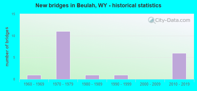
- New bridges - historical statistics
- 11960-1969
- 111970-1979
- 11980-1989
- 11990-1999
- 62010-2019

- Bridge Condition - Deck
- 33.3%Very good
- 11.1%Good
- 38.9%Satisfactory
- 11.1%Fair
- 5.6%Poor

- Bridge Condition - Superstructure
- 33.3%Very good
- 27.8%Good
- 33.3%Satisfactory
- 5.6%Fair

- Bridge Condition - Substructure
- 33.3%Very good
- 50.0%Good
- 16.7%Satisfactory

- Bridge Condition - Channel
- 27.3%Very good
- 36.4%Good
- 27.3%Satisfactory
- 9.1%Fair
Find on map >> Show street view
Structure Number: DHL, Location: Sundance - S Dakota Line (Lat: 44.537792, Lng: -104.144672), Route carried "on" structure: Interstate 90, Year Built: 1977, Status: Open, Structure Length: 2.29m (7.51ft), Average Daily Traffic: 2,978 (year 2021), Truck Traffic: 17%, Average Future Daily Traffic: 4,169 (year 2041), Design Load: HS 20+Mod, Features Intersected: Machinery Pass
Minimum Vertical Clearance: 30+ m (98+ ft), Kilometerpoint: 328.770, Lanes on structure: 2, Base Highway Network: Yes (Inventory Route: ML9, Subroute: 4), Owner: State Highway Agency, Approaching Roadway Width: 11.6m (38.1ft), Material/Design: Concrete continuous, Design/Construction: Tee Beam, Number Of Spans In Main Unit: 3, Length of Maximum Span: 9.4m (30.8ft), Curb-To-Curb Width: 12.8m (42.0ft), Out-to-Out Width: 13.6m (44.6ft)
Condition: Deck: Satisfactory, Superstructure: Satisfactory, Substructure: Good, Operating Rating: 66.2 metric tons, Method Used To Determine Operating Rating: Load Factor (LF), Inventory Rating: 39.9 metric tons, Method Used To Determine Inventory Rating: Load Factor (LF), Structural Evaluation: Equal to present minimum criteria, Deck Geometry: Equal to present desirable criteria, Approach Roadway Alignment: Equal to present desirable criteria, Designated Inspection Frequency: Every 24 months, Inspection Date: June 2021, Deck Structure Type: Concrete Cast-file-Place, Wearing Surface/Protective System: Wearing Surface: Epoxy Overlay
Find on map >> Show street view
Structure Number: DHM, Location: Sundance - S Dakota Line (Lat: 44.538050, Lng: -104.144811), Route carried "on" structure: Interstate 90, Year Built: 1977, Status: Open, Structure Length: 2.29m (7.51ft), Average Daily Traffic: 3,024 (year 2021), Truck Traffic: 17%, Average Future Daily Traffic: 4,234 (year 2041), Design Load: HS 20+Mod, Features Intersected: Machinery Pass
Minimum Vertical Clearance: 30+ m (98+ ft), Kilometerpoint: 328.567, Lanes on structure: 2, Base Highway Network: Yes (Inventory Route: ML9, Subroute: 4), Owner: State Highway Agency, Approaching Roadway Width: 11.6m (38.1ft), Material/Design: Concrete continuous, Design/Construction: Tee Beam, Number Of Spans In Main Unit: 3, Length of Maximum Span: 9.4m (30.8ft), Curb-To-Curb Width: 12.8m (42.0ft), Out-to-Out Width: 13.6m (44.6ft)
Condition: Deck: Satisfactory, Superstructure: Good, Substructure: Satisfactory, Operating Rating: 66.2 metric tons, Method Used To Determine Operating Rating: Load Factor (LF), Inventory Rating: 39.9 metric tons, Method Used To Determine Inventory Rating: Load Factor (LF), Structural Evaluation: Equal to present minimum criteria, Deck Geometry: Equal to present desirable criteria, Approach Roadway Alignment: Equal to present desirable criteria, Designated Inspection Frequency: Every 24 months, Inspection Date: June 2021, Deck Structure Type: Concrete Cast-file-Place, Wearing Surface/Protective System: Wearing Surface: Epoxy Overlay
Find on map >> Show street view
Structure Number: DHN, Location: Sundance - S Dakota Line (Lat: 44.543422, Lng: -104.093836), Route carried "on" structure: Interstate 90, Year Built: 1977, Status: Open, Structure Length: 4.45m (14.60ft), Average Daily Traffic: 2,978 (year 2021), Truck Traffic: 17%, Average Future Daily Traffic: 4,169 (year 2041), Design Load: HS 20+Mod, Features Intersected: Cr CR 108 / Rifle Pit Rd
Minimum Vertical Clearance: 30+ m (98+ ft), Kilometerpoint: 332.920, Lanes on structure: 2, Lanes under structure: 2, Base Highway Network: Yes (Inventory Route: ML9, Subroute: 4), Owner: State Highway Agency, Approaching Roadway Width: 11.6m (38.1ft), Skew: 2 degrees, Material/Design: Concrete continuous, Design/Construction: Tee Beam, Number Of Spans In Main Unit: 3, Length of Maximum Span: 19.2m (63.0ft), Curb-To-Curb Width: 12.8m (42.0ft), Out-to-Out Width: 13.6m (44.6ft)
Condition: Deck: Satisfactory, Superstructure: Satisfactory, Substructure: Good, Operating Rating: 59.9 metric tons, Method Used To Determine Operating Rating: Load Factor (LF), Inventory Rating: 35.4 metric tons, Method Used To Determine Inventory Rating: Load Factor (LF), Structural Evaluation: Equal to present minimum criteria, Deck Geometry: Equal to present desirable criteria, Underclear: Equal to present minimum criteria, Approach Roadway Alignment: Equal to present desirable criteria, Designated Inspection Frequency: Every 24 months, Inspection Date: June 2021, Deck Structure Type: Concrete Cast-file-Place, Wearing Surface/Protective System: Wearing Surface: Epoxy Overlay
Find on map >> Show street view
Structure Number: DHO, Location: Sundance - S Dakota Line (Lat: 44.543667, Lng: -104.093625), Route carried "on" structure: Interstate 90, Year Built: 1977, Status: Open, Structure Length: 4.45m (14.60ft), Average Daily Traffic: 3,024 (year 2021), Truck Traffic: 17%, Average Future Daily Traffic: 4,234 (year 2041), Design Load: HS 20+Mod, Features Intersected: Cr CR 108 / Rifle Pit Rd
Minimum Vertical Clearance: 30+ m (98+ ft), Kilometerpoint: 332.750, Lanes on structure: 2, Lanes under structure: 2, Base Highway Network: Yes (Inventory Route: ML9, Subroute: 4), Owner: State Highway Agency, Approaching Roadway Width: 12.8m (42.0ft), Skew: 2 degrees, Material/Design: Concrete continuous, Design/Construction: Tee Beam, Number Of Spans In Main Unit: 3, Length of Maximum Span: 19.2m (63.0ft), Curb-To-Curb Width: 12.8m (42.0ft), Out-to-Out Width: 13.6m (44.6ft)
Condition: Deck: Good, Superstructure: Satisfactory, Substructure: Good, Operating Rating: 59.9 metric tons, Method Used To Determine Operating Rating: Load Factor (LF), Inventory Rating: 35.4 metric tons, Method Used To Determine Inventory Rating: Load Factor (LF), Structural Evaluation: Equal to present minimum criteria, Deck Geometry: Equal to present desirable criteria, Underclear: Equal to present minimum criteria, Approach Roadway Alignment: Equal to present desirable criteria, Designated Inspection Frequency: Every 24 months, Inspection Date: June 2021, Deck Structure Type: Concrete Cast-file-Place, Wearing Surface/Protective System: Wearing Surface: Epoxy Overlay
Find on map >> Show street view
Structure Number: DHP, Location: Sundance - S Dakota Line (Lat: 44.543364, Lng: -104.092564), Route carried "on" structure: Interstate 90, Year Built: 1977, Status: Open, Structure Length: 5.00m (16.40ft), Average Daily Traffic: 2,978 (year 2021), Truck Traffic: 17%, Average Future Daily Traffic: 4,169 (year 2041), Design Load: HS 20+Mod, Features Intersected: Sand Creek
Minimum Vertical Clearance: 30+ m (98+ ft), Kilometerpoint: 333.022, Lanes on structure: 2, Base Highway Network: Yes (Inventory Route: ML9, Subroute: 4), Owner: State Highway Agency, Approaching Roadway Width: 12.8m (42.0ft), Material/Design: Steel continuous, Design/Construction: Stringer/Multi-beam, Number Of Spans In Main Unit: 3, Length of Maximum Span: 19.2m (63.0ft), Curb-To-Curb Width: 12.8m (42.0ft), Out-to-Out Width: 13.6m (44.6ft)
Condition: Deck: Poor, Superstructure: Good, Substructure: Good, Channel: Good, Operating Rating: 60.8 metric tons, Method Used To Determine Operating Rating: Load Factor (LF), Inventory Rating: 36.3 metric tons, Method Used To Determine Inventory Rating: Load Factor (LF), Structural Evaluation: Better than present minimum criteria, Deck Geometry: Equal to present desirable criteria, Waterway Adequacy: Equal to present desirable criteria, Approach Roadway Alignment: Equal to present desirable criteria, Designated Inspection Frequency: Every 24 months, Inspection Date: Febuary 2020, Deck Structure Type: Concrete Cast-file-Place
Find on map >> Show street view
Structure Number: DHQ, Location: Sundance - S Dakota Line (Lat: 44.543628, Lng: -104.092542), Route carried "on" structure: Interstate 90, Year Built: 1977, Status: Open, Structure Length: 5.00m (16.40ft), Average Daily Traffic: 3,024 (year 2021), Truck Traffic: 17%, Average Future Daily Traffic: 4,234 (year 2041), Design Load: HS 20+Mod, Features Intersected: Sand Creek
Minimum Vertical Clearance: 30+ m (98+ ft), Kilometerpoint: 332.836, Lanes on structure: 2, Base Highway Network: Yes (Inventory Route: ML9, Subroute: 4), Owner: State Highway Agency, Approaching Roadway Width: 12.8m (42.0ft), Material/Design: Steel continuous, Design/Construction: Stringer/Multi-beam, Number Of Spans In Main Unit: 3, Length of Maximum Span: 19.2m (63.0ft), Curb-To-Curb Width: 12.8m (42.0ft), Out-to-Out Width: 13.6m (44.6ft)
Condition: Deck: Fair, Superstructure: Good, Substructure: Good, Channel: Good, Operating Rating: 60.8 metric tons, Method Used To Determine Operating Rating: Load Factor (LF), Inventory Rating: 36.3 metric tons, Method Used To Determine Inventory Rating: Load Factor (LF), Structural Evaluation: Better than present minimum criteria, Deck Geometry: Equal to present desirable criteria, Waterway Adequacy: Equal to present desirable criteria, Approach Roadway Alignment: Equal to present desirable criteria, Designated Inspection Frequency: Every 24 months, Inspection Date: Febuary 2020, Deck Structure Type: Concrete Cast-file-Place
Find on map >> Show street view
Structure Number: DHR, Location: Sundance - S Dakota Line (Lat: 44.543289, Lng: -104.081061), Route carried "on" structure: County highway 129, Year Built: 1977, Status: Open, Structure Length: 7.96m (26.12ft), Average Daily Traffic: 551 (year 2021), Truck Traffic: 12%, Average Future Daily Traffic: 771 (year 2041), Design Load: HS 20+Mod, Features Intersected: I-90
Minimum Vertical Clearance: 30+ m (98+ ft), Kilometerpoint: 0.126, Lanes on structure: 2, Lanes under structure: 4, Owner: State Highway Agency, Approaching Roadway Width: 9.8m (32.2ft), Material/Design: Steel continuous, Design/Construction: Stringer/Multi-beam, Number Of Spans In Main Unit: 2, Length of Maximum Span: 39.0m (128.0ft), Curb-To-Curb Width: 9.8m (32.2ft), Out-to-Out Width: 10.6m (34.8ft)
Condition: Deck: Satisfactory, Superstructure: Good, Substructure: Good, Operating Rating: 73.5 metric tons, Method Used To Determine Operating Rating: Load Factor (LF), Inventory Rating: 43.5 metric tons, Method Used To Determine Inventory Rating: Load Factor (LF), Structural Evaluation: Better than present minimum criteria, Deck Geometry: Equal to present minimum criteria, Underclear: Somewhat better than minimum adequacy, Approach Roadway Alignment: Equal to present desirable criteria, Designated Inspection Frequency: Every 24 months, Inspection Date: Febuary 2020, Deck Structure Type: Concrete Cast-file-Place
Find on map >> Show street view
Structure Number: DHS, Location: Sundance - S Dakota Line (Lat: 44.542531, Lng: -104.069036), Route carried "on" structure: Interstate 90, Year Built: 1977, Status: Open, Structure Length: 2.29m (7.51ft), Average Daily Traffic: 2,978 (year 2021), Truck Traffic: 17%, Average Future Daily Traffic: 4,169 (year 2041), Design Load: HS 20+Mod, Features Intersected: Machinery Pass
Minimum Vertical Clearance: 30+ m (98+ ft), Kilometerpoint: 334.895, Lanes on structure: 2, Base Highway Network: Yes (Inventory Route: ML9, Subroute: 4), Owner: State Highway Agency, Approaching Roadway Width: 12.8m (42.0ft), Material/Design: Concrete continuous, Design/Construction: Tee Beam, Number Of Spans In Main Unit: 3, Length of Maximum Span: 9.4m (30.8ft), Curb-To-Curb Width: 12.8m (42.0ft), Out-to-Out Width: 13.6m (44.6ft)
Condition: Deck: Satisfactory, Superstructure: Satisfactory, Substructure: Satisfactory, Operating Rating: 66.2 metric tons, Method Used To Determine Operating Rating: Load Factor (LF), Inventory Rating: 39.9 metric tons, Method Used To Determine Inventory Rating: Load Factor (LF), Structural Evaluation: Equal to present minimum criteria, Deck Geometry: Equal to present desirable criteria, Approach Roadway Alignment: Equal to present desirable criteria, Designated Inspection Frequency: Every 24 months, Inspection Date: Febuary 2020, Deck Structure Type: Concrete Cast-file-Place
Find on map >> Show street view
Structure Number: DHT, Location: Sundance - S Dakota Line (Lat: 44.542794, Lng: -104.069031), Route carried "on" structure: Interstate 90, Year Built: 1977, Status: Open, Structure Length: 2.29m (7.51ft), Average Daily Traffic: 3,024 (year 2021), Truck Traffic: 17%, Average Future Daily Traffic: 4,234 (year 2041), Design Load: HS 20+Mod, Features Intersected: Machinery Pass
Minimum Vertical Clearance: 30+ m (98+ ft), Kilometerpoint: 334.708, Lanes on structure: 2, Base Highway Network: Yes (Inventory Route: ML9, Subroute: 4), Owner: State Highway Agency, Approaching Roadway Width: 12.8m (42.0ft), Material/Design: Concrete continuous, Design/Construction: Tee Beam, Number Of Spans In Main Unit: 3, Length of Maximum Span: 9.4m (30.8ft), Curb-To-Curb Width: 12.8m (42.0ft), Out-to-Out Width: 13.6m (44.6ft)
Condition: Deck: Satisfactory, Superstructure: Satisfactory, Substructure: Satisfactory, Operating Rating: 66.2 metric tons, Method Used To Determine Operating Rating: Load Factor (LF), Inventory Rating: 39.9 metric tons, Method Used To Determine Inventory Rating: Load Factor (LF), Structural Evaluation: Equal to present minimum criteria, Deck Geometry: Equal to present desirable criteria, Approach Roadway Alignment: Equal to present desirable criteria, Designated Inspection Frequency: Every 24 months, Inspection Date: Febuary 2020, Deck Structure Type: Concrete Cast-file-Place
Find on map >> Show street view
Structure Number: DWM, Location: 1 Mi. S.W. Of Beulah (Lat: 44.537661, Lng: -104.112417), Route carried "on" structure: County highway 108, Year Built: 1965, Status: Posted for load, Structure Length: 1.68m (5.51ft), Average Daily Traffic: 43 (year 2021), Truck Traffic: 8%, Average Future Daily Traffic: 60 (year 2041), Design Load: HS 20, Features Intersected: Sand Creek
Minimum Vertical Clearance: 30+ m (98+ ft), Kilometerpoint: 1.962, Lanes on structure: 2, Owner: County Highway Agency, Approaching Roadway Width: 5.5m (18.0ft), Material/Design: Wood or Timber, Number Of Spans In Main Unit: 3, Length of Maximum Span: 7.3m (24.0ft), Curb-To-Curb Width: 5.8m (19.0ft), Out-to-Out Width: 6.1m (20.0ft)
Condition: Deck: Satisfactory, Superstructure: Fair, Substructure: Good, Channel: Fair, Operating Rating: 12.1 metric tons, Method Used To Determine Operating Rating: Load Factor (LF), Inventory Rating: 7.8 metric tons, Method Used To Determine Inventory Rating: Load Factor (LF), Structural Evaluation: High priority of corrective action, Deck Geometry: Meets minimum limits, Waterway Adequacy: Somewhat better than minimum adequacy, Approach Roadway Alignment: Meets minimum limits, Bridge Posting: Required (Relationship of Operating Rating to Maximum Legal Load: > 39.9% below), Length Of Structure Improvement: 6.25m (20.51ft), Designated Inspection Frequency: Every 12 months, Inspection Date: March 2021, Bridge Improvement Cost: $11,000, Roadway Improvement Cost: $30,000, Total Project Cost: $42,000 ( Estimate for 2014), Deck Structure Type: Wood or Timber, Wearing Surface/Protective System: Wearing Surface: Wood or Timber
Find on map >> Show street view
Structure Number: FLC, Location: Sundance-S.D. State Line (Lat: 44.544542, Lng: -104.091425), Route carried "on" structure: ServiceOther road , Year Built: 1988, Status: Open, Structure Length: 4.30m (14.11ft), Average Daily Traffic: 712 (year 2021), Truck Traffic: 8%, Average Future Daily Traffic: 997 (year 2041), Design Load: HS 20, Features Intersected: Sand Creek, Facility Carried by Structure: I-90 Service Road
Minimum Vertical Clearance: 30+ m (98+ ft), Kilometerpoint: 2.840, Lanes on structure: 2, Owner: State Highway Agency, Approaching Roadway Width: 9.8m (32.2ft), Skew: 4 degrees, Material/Design: Steel continuous, Design/Construction: Stringer/Multi-beam, Number Of Spans In Main Unit: 4, Length of Maximum Span: 10.4m (34.1ft), Curb or Sidewalk Widths: Left: 0.0m, Right: 1.5m (4.9ft), Curb-To-Curb Width: 9.8m (32.2ft), Out-to-Out Width: 12.3m (40.4ft)
Condition: Deck: Fair, Superstructure: Good, Substructure: Good, Channel: Good, Operating Rating: 57.2 metric tons, Method Used To Determine Operating Rating: Load Factor (LF), Inventory Rating: 34.5 metric tons, Method Used To Determine Inventory Rating: Load Factor (LF), Structural Evaluation: Better than present minimum criteria, Deck Geometry: Equal to present minimum criteria, Waterway Adequacy: Equal to present desirable criteria, Approach Roadway Alignment: Equal to present desirable criteria, Designated Inspection Frequency: Every 24 months, Inspection Date: August 2020, Deck Structure Type: Concrete Cast-file-Place, Wearing Surface/Protective System: Deck Protection: Epoxy Coated Reinforcing
Find on map >> Show street view
Structure Number: KIB, Location: 1.5 Miles N. Of Beulah (Lat: 44.560444, Lng: -104.080028), Route carried "on" structure: County highway 142, Year Built: 1994, Status: Open, Structure Length: 1.52m (4.99ft), Average Daily Traffic: 74 (year 2021), Truck Traffic: 9%, Average Future Daily Traffic: 104 (year 2041), Design Load: HS 20, Features Intersected: Redwater Creek
Minimum Vertical Clearance: 30+ m (98+ ft), Kilometerpoint: 2.097, Lanes on structure: 2, Owner: County Highway Agency, Approaching Roadway Width: 6.1m (20.0ft), Material/Design: Wood or Timber, Design/Construction: Tee Beam, Number Of Spans In Main Unit: 1, Length of Maximum Span: 14.6m (47.9ft), Curb-To-Curb Width: 6.9m (22.6ft), Out-to-Out Width: 7.2m (23.6ft)
Condition: Deck: Good, Superstructure: Satisfactory, Substructure: Good, Channel: Good, Operating Rating: 42.6 metric tons, Method Used To Determine Operating Rating: Allowable Stress (AS), Inventory Rating: 32.7 metric tons, Method Used To Determine Inventory Rating: Allowable Stress (AS), Structural Evaluation: Equal to present minimum criteria, Deck Geometry: Somewhat better than minimum adequacy, Waterway Adequacy: Equal to present desirable criteria, Approach Roadway Alignment: Equal to present desirable criteria, Length Of Structure Improvement: 6.10m (20.01ft), Designated Inspection Frequency: Every 24 months, Inspection Date: April 2020, Bridge Improvement Cost: $13,000, Roadway Improvement Cost: $30,000, Total Project Cost: $44,000 ( Estimate for 2014), Deck Structure Type: Wood or Timber, Wearing Surface/Protective System: Wearing Surface: Gravel
Find on map >> Show street view
Structure Number: NAR, Location: 3.4 Mi. S.W Of Beulah (Lat: 44.504692, Lng: -104.098319), Route carried "on" structure: County highway 129, Year Built: 2017, Status: Open, Structure Length: 1.40m (4.59ft), Average Daily Traffic: 112 (year 2021), Truck Traffic: 3%, Average Future Daily Traffic: 157 (year 2041), Design Load: HL 93, Features Intersected: Sand Creek
Minimum Vertical Clearance: 30+ m (98+ ft), Kilometerpoint: 5.744, Lanes on structure: 2, Owner: County Highway Agency, Approaching Roadway Width: 8.5m (27.9ft), Material/Design: Prestressed concrete, Design/Construction: Box Beam or Girders - Multiple, Number Of Spans In Main Unit: 1, Length of Maximum Span: 0.0m, Curb-To-Curb Width: 8.5m (27.9ft), Out-to-Out Width: 8.5m (27.9ft)
Condition: Deck: Very good, Superstructure: Very good, Substructure: Very good, Channel: Satisfactory, Operating Rating: 42.1 metric tons, Method Used To Determine Operating Rating: Assigned ratings based on Load and Resistance Factor Design (LRFD) reported by rating factor (RF) using HL93 loadings, Inventory Rating: 32.4 metric tons, Method Used To Determine Inventory Rating: Assigned ratings based on Load and Resistance Factor Design (LRFD) reported by rating factor (RF) using HL93 loadings, Structural Evaluation: Equal to present desirable criteria, Deck Geometry: Equal to present minimum criteria, Waterway Adequacy: Equal to present desirable criteria, Approach Roadway Alignment: Equal to present minimum criteria, Length Of Structure Improvement: 1.80m (5.91ft), Designated Inspection Frequency: Every 24 months, Inspection Date: March 2021, Bridge Improvement Cost: $169,000, Roadway Improvement Cost: $17,000, Total Project Cost: $253,000, Deck Structure Type: Concrete Precast Panels, Wearing Surface/Protective System: Wearing Surface: Bituminous, Membrane: Preformed Fabric, Deck Protection: Epoxy Coated Reinforcing
Find on map >> Show street view
Structure Number: NAS, Location: 3.8 Mi. S.W Of Beulah (Lat: 44.502856, Lng: -104.098797), Route carried "on" structure: County highway 129, Year Built: 2017, Status: Open, Structure Length: 1.16m (3.81ft), Average Daily Traffic: 112 (year 2021), Truck Traffic: 3%, Average Future Daily Traffic: 157 (year 2041), Design Load: HL 93, Features Intersected: Sand Creek
Minimum Vertical Clearance: 30+ m (98+ ft), Kilometerpoint: 5.964, Lanes on structure: 2, Owner: County Highway Agency, Approaching Roadway Width: 9.1m (29.9ft), Material/Design: Prestressed concrete, Design/Construction: Box Beam or Girders - Multiple, Number Of Spans In Main Unit: 1, Length of Maximum Span: 0.0m, Curb-To-Curb Width: 8.5m (27.9ft), Out-to-Out Width: 8.5m (27.9ft)
Condition: Deck: Very good, Superstructure: Very good, Substructure: Very good, Channel: Satisfactory, Operating Rating: 42.1 metric tons, Method Used To Determine Operating Rating: Assigned ratings based on Load and Resistance Factor Design (LRFD) reported by rating factor (RF) using HL93 loadings, Inventory Rating: 32.4 metric tons, Method Used To Determine Inventory Rating: Assigned ratings based on Load and Resistance Factor Design (LRFD) reported by rating factor (RF) using HL93 loadings, Structural Evaluation: Equal to present desirable criteria, Deck Geometry: Equal to present minimum criteria, Waterway Adequacy: Better than present minimum criteria, Approach Roadway Alignment: Equal to present desirable criteria, Length Of Structure Improvement: 1.80m (5.91ft), Designated Inspection Frequency: Every 24 months, Inspection Date: March 2021, Bridge Improvement Cost: $169,000, Roadway Improvement Cost: $17,000, Total Project Cost: $253,000, Deck Structure Type: Concrete Precast Panels, Wearing Surface/Protective System: Wearing Surface: Bituminous, Membrane: Preformed Fabric, Deck Protection: Epoxy Coated Reinforcing
Find on map >> Show street view
Structure Number: NAT, Location: 4.0 Mi. S.W Of Beulah (Lat: 44.498422, Lng: -104.102481), Route carried "on" structure: County highway 129, Year Built: 2017, Status: Open, Structure Length: 1.40m (4.59ft), Average Daily Traffic: 112 (year 2021), Truck Traffic: 3%, Average Future Daily Traffic: 157 (year 2041), Design Load: HL 93, Features Intersected: Sand Creek
Minimum Vertical Clearance: 30+ m (98+ ft), Kilometerpoint: 6.605, Lanes on structure: 2, Owner: County Highway Agency, Approaching Roadway Width: 9.1m (29.9ft), Material/Design: Prestressed concrete, Design/Construction: Box Beam or Girders - Multiple, Number Of Spans In Main Unit: 1, Length of Maximum Span: 0.0m, Curb-To-Curb Width: 8.5m (27.9ft), Out-to-Out Width: 8.5m (27.9ft)
Condition: Deck: Very good, Superstructure: Very good, Substructure: Very good, Channel: Very good, Operating Rating: 42.1 metric tons, Method Used To Determine Operating Rating: Assigned ratings based on Load and Resistance Factor Design (LRFD) reported by rating factor (RF) using HL93 loadings, Inventory Rating: 32.4 metric tons, Method Used To Determine Inventory Rating: Assigned ratings based on Load and Resistance Factor Design (LRFD) reported by rating factor (RF) using HL93 loadings, Structural Evaluation: Equal to present desirable criteria, Deck Geometry: Equal to present minimum criteria, Waterway Adequacy: Equal to present desirable criteria, Approach Roadway Alignment: Equal to present desirable criteria, Length Of Structure Improvement: 1.80m (5.91ft), Designated Inspection Frequency: Every 24 months, Inspection Date: March 2021, Bridge Improvement Cost: $169,000, Roadway Improvement Cost: $17,000, Total Project Cost: $253,000, Deck Structure Type: Concrete Precast Panels, Wearing Surface/Protective System: Wearing Surface: Bituminous, Membrane: Preformed Fabric, Deck Protection: Epoxy Coated Reinforcing
Find on map >> Show street view
Structure Number: NAU, Location: 4.0 Mi. S.W Of Beulah (Lat: 44.496119, Lng: -104.107983), Route carried "on" structure: County highway 129, Year Built: 2017, Status: Open, Structure Length: 1.49m (4.89ft), Average Daily Traffic: 112 (year 2021), Truck Traffic: 3%, Average Future Daily Traffic: 157 (year 2041), Design Load: HL 93, Features Intersected: Sand Creek
Minimum Vertical Clearance: 30+ m (98+ ft), Kilometerpoint: 7.265, Lanes on structure: 2, Owner: County Highway Agency, Approaching Roadway Width: 9.1m (29.9ft), Material/Design: Prestressed concrete, Design/Construction: Box Beam or Girders - Multiple, Number Of Spans In Main Unit: 1, Length of Maximum Span: 0.0m, Curb-To-Curb Width: 8.5m (27.9ft), Out-to-Out Width: 8.5m (27.9ft)
Condition: Deck: Very good, Superstructure: Very good, Substructure: Very good, Channel: Satisfactory, Operating Rating: 42.1 metric tons, Method Used To Determine Operating Rating: Load and Resistance Factor Rating (LRFR) rating reported by rating factor(RF) method using HL-93 loadings, Inventory Rating: 32.4 metric tons, Method Used To Determine Inventory Rating: Load and Resistance Factor Rating (LRFR) rating reported by rating factor(RF) method using HL-93 loadings, Structural Evaluation: Equal to present desirable criteria, Deck Geometry: Equal to present minimum criteria, Waterway Adequacy: Equal to present desirable criteria, Approach Roadway Alignment: Meets minimum limits, Length Of Structure Improvement: 1.80m (5.91ft), Designated Inspection Frequency: Every 24 months, Inspection Date: March 2021, Bridge Improvement Cost: $169,000, Roadway Improvement Cost: $17,000, Total Project Cost: $253,000, Deck Structure Type: Concrete Precast Panels, Wearing Surface/Protective System: Wearing Surface: Bituminous, Membrane: Preformed Fabric, Deck Protection: Epoxy Coated Reinforcing
Find on map >> Show street view
Structure Number: NAV, Location: 4.0 Mi. S.W Of Beulah (Lat: 44.491769, Lng: -104.107631), Route carried "on" structure: County highway 129, Year Built: 2017, Status: Open, Structure Length: 1.98m (6.50ft), Average Daily Traffic: 112 (year 2021), Truck Traffic: 3%, Average Future Daily Traffic: 157 (year 2041), Design Load: HL 93, Features Intersected: Sand Creek
Minimum Vertical Clearance: 30+ m (98+ ft), Kilometerpoint: 7.828, Lanes on structure: 2, Owner: County Highway Agency, Approaching Roadway Width: 9.8m (32.2ft), Material/Design: Prestressed concrete, Design/Construction: Box Beam or Girders - Multiple, Number Of Spans In Main Unit: 1, Length of Maximum Span: 0.0m, Curb-To-Curb Width: 8.5m (27.9ft), Out-to-Out Width: 8.5m (27.9ft)
Condition: Deck: Very good, Superstructure: Very good, Substructure: Very good, Channel: Very good, Operating Rating: 42.1 metric tons, Method Used To Determine Operating Rating: Assigned ratings based on Load and Resistance Factor Design (LRFD) reported by rating factor (RF) using HL93 loadings, Inventory Rating: 32.4 metric tons, Method Used To Determine Inventory Rating: Assigned ratings based on Load and Resistance Factor Design (LRFD) reported by rating factor (RF) using HL93 loadings, Structural Evaluation: Equal to present desirable criteria, Deck Geometry: Equal to present minimum criteria, Waterway Adequacy: Equal to present desirable criteria, Approach Roadway Alignment: Equal to present minimum criteria, Length Of Structure Improvement: 1.80m (5.91ft), Designated Inspection Frequency: Every 24 months, Inspection Date: March 2021, Bridge Improvement Cost: $169,000, Roadway Improvement Cost: $17,000, Total Project Cost: $253,000, Deck Structure Type: Concrete Precast Panels, Wearing Surface/Protective System: Wearing Surface: Bituminous, Membrane: Preformed Fabric, Deck Protection: Epoxy Coated Reinforcing
Find on map >> Show street view
Structure Number: NAW, Location: 4.0 Mi. S.W Of Beulah (Lat: 44.487331, Lng: -104.117456), Route carried "on" structure: County highway 129, Year Built: 2017, Status: Open, Structure Length: 1.98m (6.50ft), Average Daily Traffic: 112 (year 2021), Truck Traffic: 3%, Average Future Daily Traffic: 157 (year 2041), Design Load: HL 93, Features Intersected: Sand Creek
Minimum Vertical Clearance: 30+ m (98+ ft), Kilometerpoint: 9.104, Lanes on structure: 2, Owner: County Highway Agency, Approaching Roadway Width: 10.1m (33.1ft), Material/Design: Prestressed concrete, Design/Construction: Box Beam or Girders - Multiple, Number Of Spans In Main Unit: 1, Length of Maximum Span: 0.0m, Curb-To-Curb Width: 8.5m (27.9ft), Out-to-Out Width: 8.5m (27.9ft)
Condition: Deck: Very good, Superstructure: Very good, Substructure: Very good, Channel: Very good, Operating Rating: 42.1 metric tons, Method Used To Determine Operating Rating: Assigned ratings based on Load and Resistance Factor Design (LRFD) reported by rating factor (RF) using HL93 loadings, Inventory Rating: 32.4 metric tons, Method Used To Determine Inventory Rating: Assigned ratings based on Load and Resistance Factor Design (LRFD) reported by rating factor (RF) using HL93 loadings, Structural Evaluation: Equal to present desirable criteria, Deck Geometry: Equal to present minimum criteria, Waterway Adequacy: Equal to present desirable criteria, Approach Roadway Alignment: Equal to present desirable criteria, Length Of Structure Improvement: 1.80m (5.91ft), Designated Inspection Frequency: Every 24 months, Inspection Date: March 2021, Bridge Improvement Cost: $169,000, Roadway Improvement Cost: $17,000, Total Project Cost: $253,000, Deck Structure Type: Concrete Precast Panels, Wearing Surface/Protective System: Wearing Surface: Bituminous, Membrane: Preformed Fabric, Deck Protection: Epoxy Coated Reinforcing
Find on map >> Show street view
Structure Number: DHR, Location: Sundance - S Dakota Line (Lat: 44.543289, Lng: -104.081061), Route carried "under" structure: Interstate 90, Year Built: 1977, Structure Length: 0. m, Average Daily Traffic: 3,024 (year 2021), Truck Traffic: 17%, Features Intersected: I-90, Facility Carried by Structure: Cr Cnty Rd 129
Minimum Vertical Clearance: 5.06m (16.60ft), Kilometerpoint: 333.749, Lanes on structure: 2, Lanes under structure: 2, Material/Design: Steel continuous, Design/Construction: Stringer/Multi-beam, Length of Maximum Span: 39.0m (128.0ft)
Find on map >> Show street view
Structure Number: DHR, Location: Sundance - S Dakota Line (Lat: 44.543289, Lng: -104.081061), Route carried "under" structure: Interstate 90, Year Built: 1977, Structure Length: 0. m, Average Daily Traffic: 2,978 (year 2021), Truck Traffic: 17%, Features Intersected: I-90, Facility Carried by Structure: Cr Cnty Rd 129
Minimum Vertical Clearance: 5.15m (16.90ft), Kilometerpoint: 333.934, Lanes on structure: 2, Lanes under structure: 2, Material/Design: Steel continuous, Design/Construction: Stringer/Multi-beam, Length of Maximum Span: 39.0m (128.0ft)