Bridge Statistics for Beverly, Massachusetts (MA)
Condition, Traffic, Stress, Structural Evaluation, Project Costs
- National Bridge Inventory (NBI) Statistics
- 13Number of bridges
- 423ft / 129mTotal length
- $91,945,000Total costs
- 279,410Total average daily traffic
- 15,365Total average daily truck traffic
- 419,151Total future (year 2031) average daily traffic
- National Bridge Inventory (NBI) Registered Bridges for Beverly
- No street view available for this location
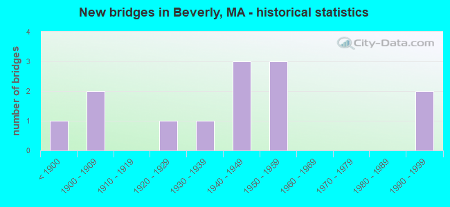
- New bridges - historical statistics
- 1Before 1900
- 21900-1909
- 11920-1929
- 11930-1939
- 31940-1949
- 31950-1959
- 21990-1999

- Reconstructed bridges - Historical Statistics
- 31970-1979
- 21980-1989
- 11990-1999


- Bridge Condition - Deck
- 22.2%Good
- 44.4%Satisfactory
- 22.2%Fair
- 11.1%Poor

- Bridge Condition - Superstructure
- 66.7%Satisfactory
- 8.3%Fair
- 25.0%Poor

- Bridge Condition - Substructure
- 8.3%Good
- 41.7%Satisfactory
- 25.0%Fair
- 25.0%Serious

- Bridge Condition - Channel
- 40.0%Good
- 20.0%Fair
- 40.0%Poor
Find on map >> Show street view
Structure Number: B11001306DOTNBI, Location: .1 MILE WEST OF RIVER ST (Lat: 42.549656, Lng: -70.887736), Route carried "on" structure: State highway , Year Built: 1929, Status: Posted for load, Structure Length: 8.20m (26.90ft), Average Daily Traffic: 21,300 (year 2018), Truck Traffic: 3%, Average Future Daily Traffic: 25,585 (year 2031), Features Intersected: WATER BASS RIVER, Facility Carried by Structure: HWY BRIDGE ST
Minimum Vertical Clearance: 30+ m (98+ ft), Kilometerpoint: 1.577, Lanes on structure: 2, Owner: State Highway Agency, Approaching Roadway Width: 9.4m (30.8ft), Material/Design: Steel, Design/Construction: Movable - Swing, Number Of Spans In Main Unit: 2, Number Of Approach Spans: 7, Length of Maximum Span: 46.6m (152.9ft), Curb or Sidewalk Widths: Left: 3.2m (10.5ft), Right: 3.2m (10.5ft), Curb-To-Curb Width: 9.8m (32.2ft), Out-to-Out Width: 16.5m (54.1ft)
Condition: Deck: Fair, Superstructure: Poor, Substructure: Serious, Channel: Fair, Operating Rating: 27.9 metric tons, Method Used To Determine Operating Rating: Load Factor (LF), Inventory Rating: 16.7 metric tons, Method Used To Determine Inventory Rating: Load Factor (LF), Structural Evaluation: High priority of corrective action, Deck Geometry: Meets minimum limits, Waterway Adequacy: Equal to present desirable criteria, Approach Roadway Alignment: Equal to present minimum criteria, Bridge Posting: Required (Relationship of Operating Rating to Maximum Legal Load: 10.0 - 19.9% below), Length Of Structure Improvement: 9.30m (30.51ft), Designated Inspection Frequency: Every 6 months, Critical Feature Inspection Frequency: Every 24 months, Underwater Inspection Frequency: Every 6 months, Other Special Inspection Frequency: Every 6 months, Inspection Date: November 2020, Critical Feature Inspection Date: November 2020, Underwater Inspection Date: December 2021, Other Special Inspection Date: November 2021, Bridge Improvement Cost: $9,792,000, Roadway Improvement Cost: $980,000, Total Project Cost: $14,689,000 ( Estimate for 2022), Deck Structure Type: Open Grating, Wearing Surface/Protective System: Wearing Surface: Other
Find on map >> Show street view
Structure Number: B11002324DOT634, Location: .1 MI WEST ST 1A (Lat: 42.543431, Lng: -70.886625), Route carried "on" structure: State highway , Year Built: 1871, Status: Open, Structure Length: 1.95m (6.40ft), Average Daily Traffic: 3,232 (year 2018), Truck Traffic: 4%, Average Future Daily Traffic: 4,330 (year 2031), Features Intersected: RR MBTA, Facility Carried by Structure: HWY SCHOOL ST
Minimum Vertical Clearance: 30+ m (98+ ft), Kilometerpoint: 0.257, Lanes on structure: 2, Owner: State Highway Agency, Approaching Roadway Width: 10.4m (34.1ft), Material/Design: Steel, Design/Construction: Girder and Floorbeam System, Number Of Spans In Main Unit: 1, Length of Maximum Span: 18.9m (62.0ft), Curb or Sidewalk Widths: Left: 1.8m (5.9ft), Right: 1.8m (5.9ft), Curb-To-Curb Width: 7.5m (24.6ft), Out-to-Out Width: 12.2m (40.0ft)
Condition: Deck: Satisfactory, Superstructure: Poor, Substructure: Fair, Operating Rating: 22.2 metric tons, Method Used To Determine Operating Rating: Load Factor (LF), Inventory Rating: 13.3 metric tons, Method Used To Determine Inventory Rating: Load Factor (LF), Structural Evaluation: Meets minimum limits, Deck Geometry: High priority of replacement, Underclear: High priority of replacement, Approach Roadway Alignment: Equal to present desirable criteria, Bridge Posting: Required (Relationship of Operating Rating to Maximum Legal Load: 30.0 - 39.9% below), Length Of Structure Improvement: 2.70m (8.86ft), Designated Inspection Frequency: Every 12 months, Critical Feature Inspection Frequency: Every 24 months, Other Special Inspection Frequency: Every 12 months, Inspection Date: November 2020, Critical Feature Inspection Date: November 2020, Other Special Inspection Date: November 2021, Bridge Improvement Cost: $2,560,000, Roadway Improvement Cost: $257,000, Total Project Cost: $3,841,000 ( Estimate for 2022), Deck Structure Type: Concrete Cast-file-Place, Wearing Surface/Protective System: Wearing Surface: Bituminous
Find on map >> Show street view
Structure Number: B110042TNDOTNBI, Location: AT DANVERS RIVER (Lat: 42.539119, Lng: -70.887608), Route carried "on" structure: Alternate State highway 1A, Year Built: 1996, Status: Open, Structure Length: 68.06m (223.29ft), Average Daily Traffic: 38,500 (year 2019), Truck Traffic: 2%, Average Future Daily Traffic: 50,538 (year 2032), Design Load: HS 20, Features Intersected: WATER DANVERS RIVER, Facility Carried by Structure: ST 1 A/CABOT ST
Minimum Vertical Clearance: 30+ m (98+ ft), Kilometerpoint: 82.036, Lanes on structure: 4, Base Highway Network: Yes, Owner: State Highway Agency, Approaching Roadway Width: 12.8m (42.0ft), Skew: 30 degrees, Navigation Control: Yes ( Vertical Clearance: 14.9m (48.9ft), Horizontal Clearance: 31.7m (104.0ft)), Material/Design: Steel continuous, Design/Construction: Stringer/Multi-beam, Number Of Spans In Main Unit: 14, Length of Maximum Span: 67.1m (220.1ft), Curb or Sidewalk Widths: Left: 0.0m, Right: 2.4m (7.9ft), Curb-To-Curb Width: 24.1m (79.1ft), Out-to-Out Width: 27.0m (88.6ft)
Condition: Deck: Good, Superstructure: Satisfactory, Substructure: Satisfactory, Channel: Good, Operating Rating: 61.8 metric tons, Method Used To Determine Operating Rating: Load Factor (LF), Inventory Rating: 37.0 metric tons, Method Used To Determine Inventory Rating: Load Factor (LF), Structural Evaluation: Equal to present minimum criteria, Deck Geometry: Superior to present desirable criteria, Waterway Adequacy: Superior to present desirable criteria, Approach Roadway Alignment: Equal to present minimum criteria, Length Of Structure Improvement: 68.10m (223.43ft), Designated Inspection Frequency: Every 24 months, Underwater Inspection Frequency: Every 36 months, Inspection Date: December 2021, Underwater Inspection Date: September 2019, Bridge Improvement Cost: $14,445,000, Roadway Improvement Cost: $1,445,000, Total Project Cost: $21,668,000 ( Estimate for 2022), Deck Structure Type: Concrete Cast-file-Place, Wearing Surface/Protective System: Wearing Surface: Monolithic Concrete, Deck Protection: Epoxy Coated Reinforcing
Find on map >> Show street view
Structure Number: B11005307DOTNBI, Location: AT DANVERS RIVER (Lat: 42.543058, Lng: -70.898333), Route carried "on" structure: State highway , Year Built: 1907, Year Reconstructed: 1982, Status: Posted for load, Structure Length: 5.70m (18.70ft), Average Daily Traffic: 3,456 (year 2021), Truck Traffic: 2%, Average Future Daily Traffic: 17,372 (year 2031), Features Intersected: WATER DANVERS RIVER, Facility Carried by Structure: HWY KERNWOOD AVE
Minimum Vertical Clearance: 4.27m (14.01ft), Kilometerpoint: 0.002, Lanes on structure: 2, Owner: State Highway Agency, Approaching Roadway Width: 9.1m (29.9ft), Navigation Control: Yes ( Vertical Clearance: 2.4m (7.9ft), Horizontal Clearance: 15.2m (49.9ft)), Material/Design: Steel, Design/Construction: Movable - Swing, Number Of Spans In Main Unit: 1, Length of Maximum Span: 55.5m (182.1ft), Curb or Sidewalk Widths: Left: 1.8m (5.9ft), Right: 0.0m, Curb-To-Curb Width: 9.1m (29.9ft), Out-to-Out Width: 10.1m (33.1ft)
Condition: Deck: Poor, Superstructure: Poor, Substructure: Serious, Channel: Poor, Operating Rating: 13.6 metric tons, Method Used To Determine Operating Rating: Load Factor (LF), Inventory Rating: 8.2 metric tons, Method Used To Determine Inventory Rating: Load Factor (LF), Structural Evaluation: High priority of replacement, Deck Geometry: High priority of replacement, Waterway Adequacy: Equal to present desirable criteria, Approach Roadway Alignment: Equal to present desirable criteria, Bridge Posting: Required (Relationship of Operating Rating to Maximum Legal Load: > 39.9% below), Length Of Structure Improvement: 6.80m (22.31ft), Designated Inspection Frequency: Every 6 months, Critical Feature Inspection Frequency: Every 24 months, Underwater Inspection Frequency: Every 12 months, Other Special Inspection Frequency: Every 6 months, Inspection Date: September 2020, Critical Feature Inspection Date: September 2020, Underwater Inspection Date: September 2021, Other Special Inspection Date: September 2021, Bridge Improvement Cost: $5,130,000, Roadway Improvement Cost: $514,000, Total Project Cost: $7,696,000 ( Estimate for 2022), Deck Structure Type: Open Grating
Find on map >> Show street view
Structure Number: B11005308DOTNBI, Location: AT DANVERS RIVER (Lat: 42.543036, Lng: -70.898347), Route carried "on" structure: State highway , Year Built: 1907, Year Reconstructed: 1992, Status: Posted for load, Structure Length: 23.01m (75.49ft), Average Daily Traffic: 6,862 (year 2018), Truck Traffic: 2%, Average Future Daily Traffic: 17,372 (year 2031), Features Intersected: WATER DANVERS RIVER, Facility Carried by Structure: HWY KERNWOOD AVE
Minimum Vertical Clearance: 30+ m (98+ ft), Kilometerpoint: 0.002, Lanes on structure: 2, Owner: State Highway Agency, Approaching Roadway Width: 9.1m (29.9ft), Navigation Control: Yes ( Vertical Clearance: 2.4m (7.9ft), Horizontal Clearance: 15.2m (49.9ft)), Material/Design: Wood or Timber, Design/Construction: Stringer/Multi-beam, Number Of Spans In Main Unit: 52, Length of Maximum Span: 4.6m (15.1ft), Curb or Sidewalk Widths: Left: 2.2m (7.2ft), Right: 0.0m, Curb-To-Curb Width: 9.1m (29.9ft), Out-to-Out Width: 12.0m (39.4ft)
Condition: Deck: Satisfactory, Superstructure: Satisfactory, Substructure: Serious, Channel: Poor, Operating Rating: 11.3 metric tons, Method Used To Determine Operating Rating: Load Factor (LF), Inventory Rating: 8.3 metric tons, Method Used To Determine Inventory Rating: Load Factor (LF), Structural Evaluation: High priority of replacement, Deck Geometry: Meets minimum limits, Waterway Adequacy: Equal to present desirable criteria, Approach Roadway Alignment: Equal to present desirable criteria, Bridge Posting: Required (Relationship of Operating Rating to Maximum Legal Load: > 39.9% below), Length Of Structure Improvement: 23.00m (75.46ft), Designated Inspection Frequency: Every 6 months, Underwater Inspection Frequency: Every 12 months, Other Special Inspection Frequency: Every 6 months, Inspection Date: September 2020, Underwater Inspection Date: September 2021, Other Special Inspection Date: September 2021, Bridge Improvement Cost: $19,638,000, Roadway Improvement Cost: $1,964,000, Total Project Cost: $29,458,000 ( Estimate for 2022), Deck Structure Type: Wood or Timber, Wearing Surface/Protective System: Wearing Surface: Bituminous
Find on map >> Show street view
Structure Number: B110092TWDOTNBI, Location: ST 97 & ST 128 (Lat: 42.574361, Lng: -70.895250), Route carried "on" structure: State highway 128, Year Built: 1947, Status: Open, Structure Length: 1.89m (6.20ft), Average Daily Traffic: 72,500 (year 2019), Truck Traffic: 6%, Average Future Daily Traffic: 72,427 (year 2032), Design Load: H 20, Features Intersected: ST 97 CABOT ST
Minimum Vertical Clearance: 30+ m (98+ ft), Kilometerpoint: 106.664, Lanes on structure: 5, Lanes under structure: 2, Base Highway Network: Yes, Owner: State Highway Agency, Approaching Roadway Width: 13.4m (44.0ft), Skew: 21 degrees, Material/Design: Concrete, Design/Construction: Frame, Number Of Spans In Main Unit: 1, Length of Maximum Span: 17.4m (57.1ft), Curb or Sidewalk Widths: Left: 1.5m (4.9ft), Right: 1.5m (4.9ft), Curb-To-Curb Width: 22.1m (72.5ft), Out-to-Out Width: 26.3m (86.3ft)
Condition: Superstructure: Satisfactory, Substructure: Satisfactory, Operating Rating: 81.0 metric tons, Method Used To Determine Operating Rating: Load Factor (LF), Inventory Rating: 47.7 metric tons, Method Used To Determine Inventory Rating: Load Factor (LF), Structural Evaluation: Equal to present minimum criteria, Deck Geometry: Meets minimum limits, Underclear: High priority of corrective action, Approach Roadway Alignment: Equal to present minimum criteria, Length Of Structure Improvement: 1.90m (6.23ft), Designated Inspection Frequency: Every 24 months, Inspection Date: December 2021, Bridge Improvement Cost: $663,000, Roadway Improvement Cost: $67,000, Total Project Cost: $995,000 ( Estimate for 2022)
Find on map >> Show street view
Structure Number: B110102TXDOTNBI, Location: JCT ST 1A & ST 128 (Lat: 42.574681, Lng: -70.892225), Route carried "on" structure: State highway 128, Year Built: 1946, Status: Open, Structure Length: 2.53m (8.30ft), Average Daily Traffic: 72,500 (year 2019), Truck Traffic: 6%, Average Future Daily Traffic: 72,427 (year 2032), Design Load: H 20, Features Intersected: ST 1 A/DODGE ST
Minimum Vertical Clearance: 30+ m (98+ ft), Kilometerpoint: 106.858, Lanes on structure: 5, Lanes under structure: 4, Base Highway Network: Yes, Owner: State Highway Agency, Approaching Roadway Width: 28.0m (91.9ft), Skew: 23 degrees, Material/Design: Concrete, Design/Construction: Frame, Number Of Spans In Main Unit: 1, Length of Maximum Span: 21.0m (68.9ft), Curb or Sidewalk Widths: Left: 1.5m (4.9ft), Right: 1.5m (4.9ft), Curb-To-Curb Width: 22.0m (72.2ft), Out-to-Out Width: 26.8m (87.9ft)
Condition: Superstructure: Satisfactory, Substructure: Satisfactory, Inventory Rating: 81.0 metric tons, Method Used To Determine Inventory Rating: Load Factor (LF), Structural Evaluation: Equal to present minimum criteria, Deck Geometry: Meets minimum limits, Underclear: High priority of corrective action, Approach Roadway Alignment: Equal to present minimum criteria, Length Of Structure Improvement: 2.60m (8.53ft), Designated Inspection Frequency: Every 24 months, Inspection Date: December 2021, Bridge Improvement Cost: $932,000, Roadway Improvement Cost: $94,000, Total Project Cost: $1,399,000 ( Estimate for 2022)
Find on map >> Show street view
Structure Number: B1101231XDOTNBI, Location: AT BRIMBALL AVE (Lat: 42.575183, Lng: -70.879125), Route carried "on" structure: State highway , Year Built: 1948, Year Reconstructed: 1990, Status: Open, Structure Length: 4.15m (13.62ft), Average Daily Traffic: 14,400 (year 2018), Truck Traffic: 11%, Average Future Daily Traffic: 22,742 (year 2031), Design Load: H 20, Features Intersected: ST128, Facility Carried by Structure: HWY BRIMBAL AVE
Minimum Vertical Clearance: 30+ m (98+ ft), Kilometerpoint: 1.371, Lanes on structure: 2, Lanes under structure: 6, Owner: State Highway Agency, Approaching Roadway Width: 9.1m (29.9ft), Skew: 4 degrees, Material/Design: Steel continuous, Design/Construction: Stringer/Multi-beam, Number Of Spans In Main Unit: 2, Length of Maximum Span: 20.1m (65.9ft), Curb or Sidewalk Widths: Left: 1.8m (5.9ft), Right: 1.8m (5.9ft), Curb-To-Curb Width: 9.2m (30.2ft), Out-to-Out Width: 14.4m (47.2ft)
Condition: Deck: Satisfactory, Superstructure: Satisfactory, Substructure: Good, Operating Rating: 69.5 metric tons, Method Used To Determine Operating Rating: Load Factor (LF), Inventory Rating: 41.6 metric tons, Method Used To Determine Inventory Rating: Load Factor (LF), Structural Evaluation: Equal to present minimum criteria, Deck Geometry: High priority of corrective action, Underclear: Somewhat better than minimum adequacy, Approach Roadway Alignment: Equal to present minimum criteria, Length Of Structure Improvement: 4.20m (13.78ft), Designated Inspection Frequency: Every 24 months, Inspection Date: September 2020, Bridge Improvement Cost: $1,664,000, Roadway Improvement Cost: $167,000, Total Project Cost: $2,497,000 ( Estimate for 2022), Deck Structure Type: Concrete Cast-file-Place, Wearing Surface/Protective System: Wearing Surface: Bituminous, Membrane: Built-up, Deck Protection: Epoxy Coated Reinforcing
Find on map >> Show street view
Structure Number: B1101430ADOTNBI, Location: 1.2 MILES S GRAPEVINE RD. (Lat: 42.572922, Lng: -70.846678), Route carried "on" structure: State highway , Year Built: 1952, Status: Open, Structure Length: 5.79m (19.00ft), Average Daily Traffic: 2,844 (year 2019), Truck Traffic: 9%, Average Future Daily Traffic: 3,159 (year 2032), Design Load: H 20, Features Intersected: ST128, Facility Carried by Structure: HWY STANDLEY ST
Minimum Vertical Clearance: 30+ m (98+ ft), Kilometerpoint: 0.563, Lanes on structure: 2, Lanes under structure: 6, Owner: State Highway Agency, Approaching Roadway Width: 9.1m (29.9ft), Material/Design: Concrete continuous, Design/Construction: Frame, Number Of Spans In Main Unit: 2, Length of Maximum Span: 15.2m (49.9ft), Curb or Sidewalk Widths: Left: 1.5m (4.9ft), Right: 0.0m, Curb-To-Curb Width: 9.1m (29.9ft), Out-to-Out Width: 12.3m (40.4ft)
Condition: Superstructure: Satisfactory, Substructure: Fair, Inventory Rating: 71.8 metric tons, Method Used To Determine Inventory Rating: Load Factor (LF), Structural Evaluation: Somewhat better than minimum adequacy, Deck Geometry: Meets minimum limits, Underclear: Meets minimum limits, Approach Roadway Alignment: Equal to present desirable criteria, Length Of Structure Improvement: 5.80m (19.03ft), Designated Inspection Frequency: Every 24 months, Inspection Date: November 2021, Bridge Improvement Cost: $2,803,000, Roadway Improvement Cost: $281,000, Total Project Cost: $4,205,000 ( Estimate for 2022), Wearing Surface/Protective System: Wearing Surface: Bituminous
Find on map >> Show street view
Structure Number: B11019BY4MUNNBI, Location: 0.2MI W OF ST97 (Lat: 42.581750, Lng: -70.905417), Route carried "on" structure: City street , Year Built: 1998, Status: Open, Structure Length: 0.73m (2.40ft), Average Daily Traffic: 2,198 (year 2019), Truck Traffic: 6%, Design Load: HS 20, Features Intersected: WATER BASS RIVER, Facility Carried by Structure: HWY SAM FONZO DR
Minimum Vertical Clearance: 30+ m (98+ ft), Kilometerpoint: 0.000, Lanes on structure: 2, Owner: Town or Township Highway Agency, Approaching Roadway Width: 10.1m (33.1ft), Material/Design: Concrete, Design/Construction: Culvert, Number Of Spans In Main Unit: 1, Length of Maximum Span: 7.3m (24.0ft), Curb or Sidewalk Widths: Left: 0.9m (3.0ft), Right: 1.5m (4.9ft), Curb-To-Curb Width: 10.1m (33.1ft), Out-to-Out Width: 10.1m (33.1ft)
Condition: Channel: Good, Culverts: Good, Structural Evaluation: Better than present minimum criteria, Deck Geometry: Meets minimum limits, Waterway Adequacy: Equal to present desirable criteria, Approach Roadway Alignment: Equal to present minimum criteria, Length Of Structure Improvement: 0.40m (1.31ft), Designated Inspection Frequency: Every 24 months, Inspection Date: July 2021, Bridge Improvement Cost: $276,000, Roadway Improvement Cost: $28,000, Total Project Cost: $415,000 ( Estimate for 2022), Wearing Surface/Protective System: Wearing Surface: Bituminous
Find on map >> Show street view
Structure Number: M0200632GDOT634, Location: .25 MILES E ST 127 (Lat: 42.566428, Lng: -70.783400), Route carried "on" structure: State highway , Year Built: 1936, Year Reconstructed: 1985, Status: Posted for load, Structure Length: 1.22m (4.00ft), Average Daily Traffic: 900 (year 2018), Truck Traffic: 17%, Average Future Daily Traffic: 537 (year 2033), Features Intersected: RR MBTA, Facility Carried by Structure: HWY HARBOR ST
Minimum Vertical Clearance: 30+ m (98+ ft), Kilometerpoint: 0.002, Lanes on structure: 2, Owner: State Highway Agency, Approaching Roadway Width: 11.3m (37.1ft), Skew: 1 degrees, Material/Design: Wood or Timber, Design/Construction: Stringer/Multi-beam, Number Of Spans In Main Unit: 1, Length of Maximum Span: 11.0m (36.1ft), Curb or Sidewalk Widths: Left: 0.0m, Right: 1.8m (5.9ft), Curb-To-Curb Width: 8.2m (26.9ft), Out-to-Out Width: 10.6m (34.8ft)
Condition: Deck: Good, Superstructure: Fair, Substructure: Satisfactory, Operating Rating: 26.6 metric tons, Method Used To Determine Operating Rating: Allowable Stress (AS), Inventory Rating: 18.4 metric tons, Method Used To Determine Inventory Rating: Allowable Stress (AS), Structural Evaluation: Somewhat better than minimum adequacy, Deck Geometry: Somewhat better than minimum adequacy, Underclear: High priority of corrective action, Approach Roadway Alignment: High priority of corrective action, Bridge Posting: Required (Relationship of Operating Rating to Maximum Legal Load: 10.0 - 19.9% below), Length Of Structure Improvement: 1.30m (4.27ft), Designated Inspection Frequency: Every 24 months, Inspection Date: January 2022, Bridge Improvement Cost: $542,000, Roadway Improvement Cost: $55,000, Total Project Cost: $814,000 ( Estimate for 2022), Deck Structure Type: Wood or Timber, Wearing Surface/Protective System: Wearing Surface: Wood or Timber
Find on map >> Show street view
Structure Number: M020142UCDOTNBI, Location: .8 MI N MANCHESTER TOWN H (Lat: 42.590392, Lng: -70.793311), Route carried "on" structure: US 128, Year Built: 1953, Year Reconstructed: 1982, Status: Open, Structure Length: 2.65m (8.69ft), Average Daily Traffic: 21,218 (year 2019), Truck Traffic: 4%, Average Future Daily Traffic: 66,331 (year 2031), Design Load: H 20, Features Intersected: HWY PINE ST
Minimum Vertical Clearance: 30+ m (98+ ft), Kilometerpoint: 20.969, Lanes on structure: 2, Lanes under structure: 2, Base Highway Network: Yes, Owner: State Highway Agency, Approaching Roadway Width: 13.4m (44.0ft), Skew: 6 degrees, Material/Design: Steel, Design/Construction: Stringer/Multi-beam, Number Of Spans In Main Unit: 1, Length of Maximum Span: 25.6m (84.0ft), Curb-To-Curb Width: 12.3m (40.4ft), Out-to-Out Width: 13.4m (44.0ft)
Condition: Deck: Fair, Superstructure: Satisfactory, Substructure: Fair, Operating Rating: 50.0 metric tons, Method Used To Determine Operating Rating: Load Factor (LF), Inventory Rating: 29.9 metric tons, Method Used To Determine Inventory Rating: Load Factor (LF), Structural Evaluation: Somewhat better than minimum adequacy, Deck Geometry: Better than present minimum criteria, Underclear: Meets minimum limits, Approach Roadway Alignment: Equal to present desirable criteria, Length Of Structure Improvement: 2.70m (8.86ft), Designated Inspection Frequency: Every 24 months, Inspection Date: October 2020, Bridge Improvement Cost: $1,422,000, Roadway Improvement Cost: $143,000, Total Project Cost: $2,134,000 ( Estimate for 2022), Deck Structure Type: Concrete Cast-file-Place, Wearing Surface/Protective System: Wearing Surface: Bituminous, Membrane: Built-up, Deck Protection: Epoxy Coated Reinforcing
Find on map >> Show street view
Structure Number: M020142UDDOTNBI, Location: .8 MI N MANCHESTER TOWN H (Lat: 42.590497, Lng: -70.793600), Route carried "on" structure: State highway 128, Year Built: 1953, Year Reconstructed: 1982, Status: Open, Structure Length: 2.65m (8.69ft), Average Daily Traffic: 19,500 (year 2016), Truck Traffic: 10%, Average Future Daily Traffic: 66,331 (year 2031), Design Load: H 20, Features Intersected: HWY PINE ST
Minimum Vertical Clearance: 30+ m (98+ ft), Kilometerpoint: 20.969, Lanes on structure: 2, Lanes under structure: 2, Base Highway Network: Yes, Owner: State Highway Agency, Approaching Roadway Width: 13.4m (44.0ft), Skew: 16 degrees, Material/Design: Steel, Design/Construction: Stringer/Multi-beam, Number Of Spans In Main Unit: 1, Length of Maximum Span: 25.6m (84.0ft), Curb-To-Curb Width: 12.3m (40.4ft), Out-to-Out Width: 13.4m (44.0ft)
Condition: Deck: Satisfactory, Superstructure: Satisfactory, Substructure: Satisfactory, Operating Rating: 50.0 metric tons, Method Used To Determine Operating Rating: Load Factor (LF), Inventory Rating: 29.9 metric tons, Method Used To Determine Inventory Rating: Load Factor (LF), Structural Evaluation: Equal to present minimum criteria, Deck Geometry: Better than present minimum criteria, Underclear: Meets minimum limits, Approach Roadway Alignment: Equal to present desirable criteria, Length Of Structure Improvement: 2.70m (8.86ft), Designated Inspection Frequency: Every 24 months, Inspection Date: October 2020, Bridge Improvement Cost: $1,422,000, Roadway Improvement Cost: $143,000, Total Project Cost: $2,134,000 ( Estimate for 2022), Deck Structure Type: Concrete Cast-file-Place, Wearing Surface/Protective System: Wearing Surface: Bituminous, Membrane: Built-up, Deck Protection: Epoxy Coated Reinforcing