Bridge Statistics for Blandford, Massachusetts (MA)
Condition, Traffic, Stress, Structural Evaluation, Project Costs
- National Bridge Inventory (NBI) Statistics
- 15Number of bridges
- 75ft / 22.8mTotal length
- $13,429,000Total costs
- 102,954Total average daily traffic
- 13,450Total average daily truck traffic
- National Bridge Inventory (NBI) Registered Bridges for Blandford
- No street view available for this location
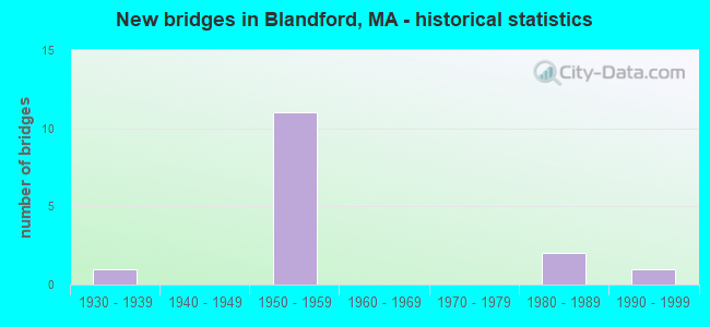
- New bridges - historical statistics
- 11930-1939
- 111950-1959
- 21980-1989
- 11990-1999

- Reconstructed bridges - Historical Statistics
- 11980-1989
- 31990-1999


- Bridge Condition - Superstructure
- 33.3%Good
- 66.7%Satisfactory

- Bridge Condition - Substructure
- 33.3%Good
- 50.0%Satisfactory
- 16.7%Fair

- Bridge Condition - Channel
- 40.0%Good
- 40.0%Satisfactory
- 20.0%Fair

- Bridge Condition - Culverts
- 33.3%Good
- 66.7%Satisfactory
Find on map >> Show street view
Structure Number: B1400400KMUNNBI, Location: .3 MI W OF BLANDFORD TL (Lat: 42.180239, Lng: -72.888528), Route carried "on" structure: City street , Year Built: 1956, Status: Open, Structure Length: 0.88m (2.89ft), Average Daily Traffic: 517 (year 2018), Truck Traffic: 6%, Average Future Daily Traffic: 948 (year 2033), Design Load: H 20, Features Intersected: WATER FREELAND BROOK, Facility Carried by Structure: HWY RUSSEL STAGE
Minimum Vertical Clearance: 30+ m (98+ ft), Kilometerpoint: 0.000, Lanes on structure: 2, Owner: Town or Township Highway Agency, Approaching Roadway Width: 8.5m (27.9ft), Skew: 2 degrees, Material/Design: Prestressed concrete, Design/Construction: Slab, Number Of Spans In Main Unit: 1, Length of Maximum Span: 7.7m (25.3ft), Curb or Sidewalk Widths: Left: 0.3m (1.0ft), Right: 0.3m (1.0ft), Curb-To-Curb Width: 9.1m (29.9ft), Out-to-Out Width: 9.8m (32.2ft)
Condition: Deck: Satisfactory, Superstructure: Satisfactory, Substructure: Good, Channel: Good, Inventory Rating: 70.2 metric tons, Method Used To Determine Inventory Rating: Load Factor (LF), Structural Evaluation: Equal to present minimum criteria, Deck Geometry: Equal to present minimum criteria, Waterway Adequacy: Equal to present desirable criteria, Approach Roadway Alignment: Equal to present desirable criteria, Length Of Structure Improvement: 0.90m (2.95ft), Designated Inspection Frequency: Every 24 months, Inspection Date: August 2021, Bridge Improvement Cost: $264,000, Roadway Improvement Cost: $27,000, Total Project Cost: $397,000 ( Estimate for 2022), Deck Structure Type: Concrete Precast Panels, Wearing Surface/Protective System: Wearing Surface: Bituminous
Find on map >> Show street view
Structure Number: B1400703EMUNNBI, Location: 0.2MI S OF N.BLAND. RD (Lat: 42.207014, Lng: -72.980542), Route carried "on" structure: City street , Year Built: 1984, Status: Posted for load, Structure Length: 1.17m (3.84ft), Average Daily Traffic: 259 (year 2018), Truck Traffic: 6%, Average Future Daily Traffic: 158 (year 2031), Design Load: H 20, Features Intersected: WATER WHEELER BROOK, Facility Carried by Structure: HWY BLAIR RD
Minimum Vertical Clearance: 30+ m (98+ ft), Kilometerpoint: 0.000, Lanes on structure: 2, Owner: Town or Township Highway Agency, Approaching Roadway Width: 6.7m (22.0ft), Material/Design: Concrete, Design/Construction: Culvert, Number Of Spans In Main Unit: 3, Length of Maximum Span: 3.0m (9.8ft)
Condition: Channel: Satisfactory, Culverts: Satisfactory, Operating Rating: 58.5 metric tons, Method Used To Determine Operating Rating: Allowable Stress (AS), Inventory Rating: 22.4 metric tons, Method Used To Determine Inventory Rating: Allowable Stress (AS), Structural Evaluation: Equal to present minimum criteria, Waterway Adequacy: Better than present minimum criteria, Approach Roadway Alignment: Equal to present desirable criteria, Length Of Structure Improvement: 0.70m (2.30ft), Designated Inspection Frequency: Every 24 months, Underwater Inspection Frequency: Every 24 months, Inspection Date: August 2020, Underwater Inspection Date: September 2020, Bridge Improvement Cost: $322,000, Roadway Improvement Cost: $33,000, Total Project Cost: $484,000 ( Estimate for 2022)
Find on map >> Show street view
Structure Number: B1401653UMUNNBI, Location: 200'W. OF INT.W/BLAIR RD. (Lat: 42.210278, Lng: -72.982222), Route carried "on" structure: City street , Year Built: 1994, Status: Open, Structure Length: 0.73m (2.40ft), Average Daily Traffic: 388 (year 2020), Truck Traffic: 12%, Average Future Daily Traffic: 221 (year 2031), Design Load: HS 20, Features Intersected: WATER PEEBLE BROOK, Facility Carried by Structure: HWY N BLNDFRD RD
Minimum Vertical Clearance: 30+ m (98+ ft), Kilometerpoint: 0.000, Lanes on structure: 2, Owner: Town or Township Highway Agency, Approaching Roadway Width: 6.1m (20.0ft), Skew: 2 degrees, Material/Design: Concrete, Design/Construction: Culvert, Number Of Spans In Main Unit: 2, Length of Maximum Span: 3.4m (11.2ft)
Condition: Channel: Fair, Culverts: Good, Inventory Rating: 61.3 metric tons, Method Used To Determine Inventory Rating: Load Factor (LF), Structural Evaluation: Better than present minimum criteria, Waterway Adequacy: Better than present minimum criteria, Approach Roadway Alignment: Equal to present desirable criteria, Length Of Structure Improvement: 0.60m (1.97ft), Designated Inspection Frequency: Every 24 months, Inspection Date: August 2020, Bridge Improvement Cost: $375,000, Roadway Improvement Cost: $38,000, Total Project Cost: $563,000 ( Estimate for 2022)
Find on map >> Show street view
Structure Number: B1401703FMUNNBI, Location: 0.6MI S OF RT23 NEAR RES (Lat: 42.167222, Lng: -72.948611), Route carried "on" structure: City street , Year Built: 1930, Status: Posted for load, Structure Length: 1.10m (3.61ft), Average Daily Traffic: 120 (year 2016), Truck Traffic: 6%, Average Future Daily Traffic: 268 (year 2033), Features Intersected: WATER POND BROOK, Facility Carried by Structure: HWY BEECH HLL RD
Minimum Vertical Clearance: 30+ m (98+ ft), Kilometerpoint: 0.000, Lanes on structure: 2, Owner: Town or Township Highway Agency, Approaching Roadway Width: 6.1m (20.0ft), Material/Design: Concrete, Design/Construction: Arch - Deck, Number Of Spans In Main Unit: 1, Length of Maximum Span: 11.0m (36.1ft), Curb-To-Curb Width: 5.2m (17.1ft), Out-to-Out Width: 6.1m (20.0ft)
Condition: Superstructure: Good, Substructure: Good, Channel: Good, Operating Rating: 37.2 metric tons, Method Used To Determine Operating Rating: Load Factor (LF), Inventory Rating: 22.3 metric tons, Method Used To Determine Inventory Rating: Load Factor (LF), Structural Evaluation: Equal to present minimum criteria, Deck Geometry: High priority of replacement, Waterway Adequacy: Better than present minimum criteria, Approach Roadway Alignment: Equal to present minimum criteria, Length Of Structure Improvement: 1.20m (3.94ft), Designated Inspection Frequency: Every 24 months, Inspection Date: August 2021, Bridge Improvement Cost: $288,000, Roadway Improvement Cost: $29,000, Total Project Cost: $433,000 ( Estimate for 2022)
Find on map >> Show street view
Structure Number: B140214G6DOTNBI, Location: 26.1 MILE MARKER (Lat: 42.226714, Lng: -72.972022), Route carried "on" structure: City street , Year Built: 1957, Year Reconstructed: 1996, Status: Open, Structure Length: 5.70m (18.70ft), Average Daily Traffic: 200 (year 2010), Truck Traffic: 5%, Average Future Daily Traffic: 316 (year 2033), Design Load: HS 20, Features Intersected: I 90, Facility Carried by Structure: HWY OLD CHSTR RD
Minimum Vertical Clearance: 30+ m (98+ ft), Kilometerpoint: 42.003, Lanes on structure: 2, Lanes under structure: 4, Owner: State Highway Agency, Approaching Roadway Width: 7.3m (24.0ft), Material/Design: Steel continuous, Design/Construction: Stringer/Multi-beam, Number Of Spans In Main Unit: 4, Length of Maximum Span: 18.9m (62.0ft), Curb or Sidewalk Widths: Left: 0.8m (2.6ft), Right: 1.8m (5.9ft), Curb-To-Curb Width: 7.3m (24.0ft), Out-to-Out Width: 10.8m (35.4ft)
Condition: Deck: Satisfactory, Superstructure: Good, Substructure: Satisfactory, Operating Rating: 75.2 metric tons, Method Used To Determine Operating Rating: Load Factor (LF), Inventory Rating: 45.0 metric tons, Method Used To Determine Inventory Rating: Load Factor (LF), Structural Evaluation: Equal to present minimum criteria, Deck Geometry: Somewhat better than minimum adequacy, Underclear: High priority of corrective action, Approach Roadway Alignment: Equal to present desirable criteria, Length Of Structure Improvement: 5.80m (19.03ft), Designated Inspection Frequency: Every 24 months, Inspection Date: April 2020, Bridge Improvement Cost: $2,024,000, Roadway Improvement Cost: $203,000, Total Project Cost: $3,037,000 ( Estimate for 2022), Deck Structure Type: Concrete Cast-file-Place, Wearing Surface/Protective System: Wearing Surface: Bituminous, Membrane: Built-up, Deck Protection: Epoxy Coated Reinforcing
Find on map >> Show street view
Structure Number: B140224G5DOTNBI, Location: 28.8 MILE MARKER (Lat: 42.198492, Lng: -72.937475), Route carried "on" structure: City street , Year Built: 1957, Year Reconstructed: 1994, Status: Open, Structure Length: 7.96m (26.12ft), Average Daily Traffic: 800 (year 2010), Truck Traffic: 7%, Average Future Daily Traffic: 1,263 (year 2033), Design Load: HS 20, Features Intersected: I 90, Facility Carried by Structure: HWY NORTH ST
Minimum Vertical Clearance: 30+ m (98+ ft), Kilometerpoint: 46.348, Lanes on structure: 2, Lanes under structure: 4, Base Highway Network: Yes, Owner: State Highway Agency, Approaching Roadway Width: 9.1m (29.9ft), Skew: 4 degrees, Material/Design: Steel continuous, Design/Construction: Stringer/Multi-beam, Number Of Spans In Main Unit: 2, Number Of Approach Spans: 2, Length of Maximum Span: 21.3m (69.9ft), Curb or Sidewalk Widths: Left: 0.8m (2.6ft), Right: 1.8m (5.9ft), Curb-To-Curb Width: 9.1m (29.9ft), Out-to-Out Width: 12.6m (41.3ft)
Condition: Deck: Satisfactory, Superstructure: Satisfactory, Substructure: Fair, Operating Rating: 42.1 metric tons, Method Used To Determine Operating Rating: Load Factor (LF), Inventory Rating: 25.2 metric tons, Method Used To Determine Inventory Rating: Load Factor (LF), Structural Evaluation: Somewhat better than minimum adequacy, Deck Geometry: Equal to present minimum criteria, Underclear: High priority of corrective action, Approach Roadway Alignment: Equal to present desirable criteria, Length Of Structure Improvement: 8.00m (26.25ft), Designated Inspection Frequency: Every 24 months, Inspection Date: April 2020, Bridge Improvement Cost: $3,960,000, Roadway Improvement Cost: $397,000, Total Project Cost: $5,941,000 ( Estimate for 2022), Deck Structure Type: Concrete Cast-file-Place, Wearing Surface/Protective System: Wearing Surface: Bituminous, Membrane: Built-up, Deck Protection: Epoxy Coated Reinforcing
Find on map >> Show street view
Structure Number: B140234G3DOTNBI, Location: 0.35 MI. N. OF RTE 23 C3 (Lat: 42.182911, Lng: -72.921417), Route carried "on" structure: Interstate 90, Year Built: 1957, Year Reconstructed: 1990, Status: Open, Structure Length: 2.15m (7.05ft), Average Daily Traffic: 30,141 (year 2016), Truck Traffic: 22%, Average Future Daily Traffic: 44,023 (year 2032), Design Load: HS 20, Features Intersected: HWY RUSSELL STAGE RD
Minimum Vertical Clearance: 30+ m (98+ ft), Kilometerpoint: 48.440, Lanes on structure: 2, Lanes under structure: 2, Base Highway Network: Yes, Toll: On toll road, Owner: State Highway Agency, Approaching Roadway Width: 12.9m (42.3ft), Skew: 4 degrees, Material/Design: Steel, Design/Construction: Stringer/Multi-beam, Number Of Spans In Main Unit: 1, Length of Maximum Span: 18.6m (61.0ft), Curb-To-Curb Width: 12.9m (42.3ft), Out-to-Out Width: 13.8m (45.3ft)
Condition: Deck: Satisfactory, Superstructure: Satisfactory, Substructure: Satisfactory, Operating Rating: 61.9 metric tons, Method Used To Determine Operating Rating: Load Factor (LF), Inventory Rating: 37.1 metric tons, Method Used To Determine Inventory Rating: Load Factor (LF), Structural Evaluation: Equal to present minimum criteria, Deck Geometry: Superior to present desirable criteria, Underclear: Meets minimum limits, Approach Roadway Alignment: Equal to present desirable criteria, Length Of Structure Improvement: 2.20m (7.22ft), Designated Inspection Frequency: Every 24 months, Inspection Date: April 2021, Bridge Improvement Cost: $239,000, Roadway Improvement Cost: $24,000, Total Project Cost: $359,000 ( Estimate for 2022), Deck Structure Type: Concrete Cast-file-Place, Wearing Surface/Protective System: Wearing Surface: Bituminous, Membrane: Built-up, Deck Protection: Epoxy Coated Reinforcing
Find on map >> Show street view
Structure Number: B140234G4DOTNBI, Location: 0.35 MI. N. OF RTE 23 C3 (Lat: 42.182956, Lng: -72.920919), Route carried "on" structure: Interstate 90, Year Built: 1957, Year Reconstructed: 1990, Status: Open, Structure Length: 2.15m (7.05ft), Average Daily Traffic: 30,141 (year 2016), Truck Traffic: 22%, Average Future Daily Traffic: 44,220 (year 2032), Design Load: HS 20, Features Intersected: HWY RUSSELL STAGE RD
Minimum Vertical Clearance: 30+ m (98+ ft), Kilometerpoint: 48.440, Lanes on structure: 3, Lanes under structure: 2, Base Highway Network: Yes, Toll: On toll road, Owner: State Highway Agency, Approaching Roadway Width: 12.9m (42.3ft), Skew: 4 degrees, Material/Design: Steel, Design/Construction: Stringer/Multi-beam, Number Of Spans In Main Unit: 1, Length of Maximum Span: 18.6m (61.0ft), Curb-To-Curb Width: 12.9m (42.3ft), Out-to-Out Width: 13.8m (45.3ft)
Condition: Deck: Satisfactory, Superstructure: Satisfactory, Substructure: Satisfactory, Operating Rating: 62.0 metric tons, Method Used To Determine Operating Rating: Load Factor (LF), Inventory Rating: 37.2 metric tons, Method Used To Determine Inventory Rating: Load Factor (LF), Structural Evaluation: Equal to present minimum criteria, Deck Geometry: High priority of replacement, Underclear: Meets minimum limits, Approach Roadway Alignment: Equal to present desirable criteria, Length Of Structure Improvement: 2.20m (7.22ft), Designated Inspection Frequency: Every 24 months, Inspection Date: April 2021, Bridge Improvement Cost: $1,141,000, Roadway Improvement Cost: $115,000, Total Project Cost: $1,712,000 ( Estimate for 2022), Deck Structure Type: Concrete Cast-file-Place, Wearing Surface/Protective System: Wearing Surface: Bituminous, Membrane: Built-up, Deck Protection: Epoxy Coated Reinforcing
Find on map >> Show street view
Structure Number: B14024AQYMUNNBI, Location: AT INT. W/ NYE BROOK ROAD (Lat: 42.181964, Lng: -72.892408), Route carried "on" structure: City street , Year Built: 1988, Status: Open, Structure Length: 0.97m (3.18ft), Average Daily Traffic: 388 (year 2018), Truck Traffic: 6%, Average Future Daily Traffic: 790 (year 2031), Design Load: HS 20, Features Intersected: WATER FREELAND BROOK, Facility Carried by Structure: HWY RUSSEL STAGE
Minimum Vertical Clearance: 30+ m (98+ ft), Kilometerpoint: 0.000, Lanes on structure: 2, Owner: Town or Township Highway Agency, Approaching Roadway Width: 7.8m (25.6ft), Skew: 4 degrees, Material/Design: Concrete, Design/Construction: Culvert, Number Of Spans In Main Unit: 2, Length of Maximum Span: 4.3m (14.1ft)
Condition: Channel: Satisfactory, Culverts: Satisfactory, Operating Rating: 90.7 metric tons, Method Used To Determine Operating Rating: Load Factor (LF), Inventory Rating: 55.1 metric tons, Method Used To Determine Inventory Rating: Load Factor (LF), Structural Evaluation: Equal to present minimum criteria, Waterway Adequacy: Better than present minimum criteria, Approach Roadway Alignment: Better than present minimum criteria, Length Of Structure Improvement: 0.50m (1.64ft), Designated Inspection Frequency: Every 24 months, Inspection Date: August 2021, Bridge Improvement Cost: $335,000, Roadway Improvement Cost: $34,000, Total Project Cost: $503,000 ( Estimate for 2022)
Find on map >> Show street view
Structure Number: B140214G6DOTNBI, Location: 0.1 M S CHESTER RD (Lat: 42.233333, Lng: -72.966667), Route carried "under" structure: Interstate 90, Year Built: 1957, Structure Length: 0. m, Average Daily Traffic: 10,000 (year 0000), Features Intersected: I 90 EB, Facility Carried by Structure: HWY OLD CHSTR RD
Minimum Vertical Clearance: 4.34m (14.24ft), Kilometerpoint: 42.003, Lanes on structure: 2, Lanes under structure: 2, Toll: On toll road, Material/Design: Steel, Design/Construction: Stringer/Multi-beam, Length of Maximum Span: 18.9m (62.0ft)
Find on map >> Show street view
Structure Number: B140214G6DOTNBI, Location: .1MI.S.CHESTER RD (Lat: 42.233333, Lng: -72.966667), Route carried "under" structure: Interstate 90, Year Built: 1957, Structure Length: 0. m, Average Daily Traffic: 10,000 (year 0000), Features Intersected: I 90 WB, Facility Carried by Structure: HWY OLD CHSTR RD
Minimum Vertical Clearance: 4.34m (14.24ft), Kilometerpoint: 42.003, Lanes on structure: 2, Lanes under structure: 2, Toll: On toll road, Material/Design: Steel, Design/Construction: Stringer/Multi-beam, Length of Maximum Span: 18.9m (62.0ft)
Find on map >> Show street view
Structure Number: B140224G5DOTNBI, Location: 0.1 MI N GORE RD (Lat: 42.200000, Lng: -72.933333), Route carried "under" structure: Interstate 90, Year Built: 1957, Structure Length: 0. m, Average Daily Traffic: 10,000 (year 0000), Features Intersected: I 90 EB, Facility Carried by Structure: HWY NORTH ST
Minimum Vertical Clearance: 4.36m (14.30ft), Kilometerpoint: 46.348, Lanes on structure: 2, Lanes under structure: 2, Toll: On toll road, Material/Design: Steel, Design/Construction: Stringer/Multi-beam, Length of Maximum Span: 21.3m (69.9ft)
Find on map >> Show street view
Structure Number: B140224G5DOTNBI, Location: .1MI.N.GORE RD (Lat: 42.200000, Lng: -72.933333), Route carried "under" structure: Interstate 90, Year Built: 1957, Structure Length: 0. m, Average Daily Traffic: 10,000 (year 0000), Features Intersected: I 90 WB, Facility Carried by Structure: HWY NORTH ST
Minimum Vertical Clearance: 4.36m (14.30ft), Kilometerpoint: 46.348, Lanes on structure: 2, Lanes under structure: 2, Toll: On toll road, Material/Design: Steel, Design/Construction: Stringer/Multi-beam, Length of Maximum Span: 18.9m (62.0ft)
Find on map >> Show street view
Structure Number: B140234G3DOTNBI, Location: .35 MI N OF RTE 23 (Lat: 42.182911, Lng: -72.921417), Route carried "under" structure: City street , Year Built: 1957, Structure Length: 0. m, Features Intersected: HWY RUSSELL STAGE RD, Facility Carried by Structure: I 90 EB
Minimum Vertical Clearance: 4.24m (13.91ft), Kilometerpoint: 0.000, Lanes on structure: 2, Lanes under structure: 2, Material/Design: Steel, Design/Construction: Stringer/Multi-beam, Length of Maximum Span: 18.6m (61.0ft)
Find on map >> Show street view
Structure Number: B140234G4DOTNBI, Location: .35 N OFBRTE 23 (Lat: 42.182956, Lng: -72.920919), Route carried "under" structure: City street , Year Built: 1957, Structure Length: 0. m, Features Intersected: HWY RUSSELL STAGE RD, Facility Carried by Structure: I 90 WB
Minimum Vertical Clearance: 4.72m (15.49ft), Kilometerpoint: 0.000, Lanes on structure: 2, Lanes under structure: 2, Material/Design: Steel, Design/Construction: Stringer/Multi-beam, Length of Maximum Span: 18.6m (61.0ft)