Bridge Statistics for Boardman, Oregon (OR)
Condition, Traffic, Stress, Structural Evaluation, Project Costs
- National Bridge Inventory (NBI) Statistics
- 18Number of bridges
- 203ft / 61.9mTotal length
- $2,224,000Total costs
- 186,948Total average daily traffic
- 21,993Total average daily truck traffic
- National Bridge Inventory (NBI) Registered Bridges for Boardman
- No street view available for this location
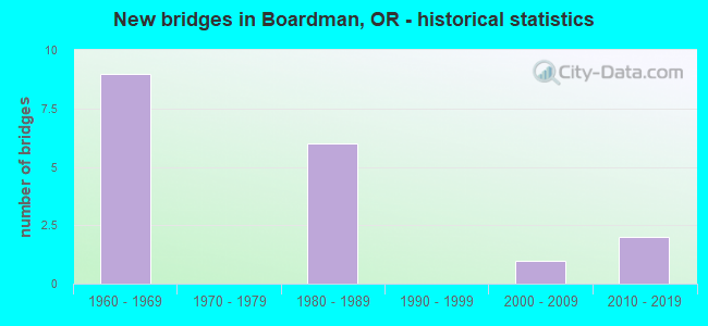
- New bridges - historical statistics
- 91960-1969
- 61980-1989
- 12000-2009
- 22010-2019


- Bridge Condition - Deck
- 7.7%Very good
- 46.2%Good
- 38.5%Satisfactory
- 7.7%Fair

- Bridge Condition - Superstructure
- 7.7%Very good
- 38.5%Good
- 53.8%Satisfactory

- Bridge Condition - Substructure
- 7.7%Very good
- 61.5%Good
- 15.4%Satisfactory
- 15.4%Fair
Find on map >> Show street view
Structure Number: 8884 002 16877, Location: 01.2 MI NE JCT FAI-84 (Lat: 45.840478, Lng: -119.610986), Route carried "on" structure: US 730, Year Built: 1962, Status: Open, Structure Length: 6.80m (22.31ft), Average Daily Traffic: 3,396 (year 2020), Truck Traffic: 13%, Average Future Daily Traffic: 3,500 (year 2040), Design Load: HS 20, Features Intersected: UPRR (CLARKE)
Minimum Vertical Clearance: 30+ m (98+ ft), Kilometerpoint: 271.609, Lanes on structure: 2, Base Highway Network: Yes, Owner: State Highway Agency, Approaching Roadway Width: 13.4m (44.0ft), Skew: 3 degrees, Material/Design: Steel, Design/Construction: Stringer/Multi-beam, Number Of Spans In Main Unit: 1, Number Of Approach Spans: 4, Length of Maximum Span: 25.0m (82.0ft), Curb-To-Curb Width: 9.1m (29.9ft), Out-to-Out Width: 10.5m (34.4ft)
Condition: Deck: Satisfactory, Superstructure: Satisfactory, Substructure: Fair, Operating Rating: 32.7 metric tons, Method Used To Determine Operating Rating: Load and Resistance Factor Rating (LRFR) rating reported by rating factor(RF) method using HL-93 loadings, Inventory Rating: 25.3 metric tons, Method Used To Determine Inventory Rating: Load and Resistance Factor Rating (LRFR) rating reported by rating factor(RF) method using HL-93 loadings, Structural Evaluation: Somewhat better than minimum adequacy, Deck Geometry: Meets minimum limits, Underclear: Somewhat better than minimum adequacy, Approach Roadway Alignment: Equal to present desirable criteria, Designated Inspection Frequency: Every 24 months, Inspection Date: Febuary 2021, Deck Structure Type: Concrete Cast-file-Place, Wearing Surface/Protective System: Wearing Surface: Latex Concrete
Find on map >> Show street view
Structure Number: 8885 002 16886, Location: 9.8 MI W UMATILLA CO LINE (Lat: 45.841247, Lng: -119.609481), Route carried "on" structure: US 730, Year Built: 1962, Status: Open, Structure Length: 3.81m (12.50ft), Average Daily Traffic: 3,396 (year 2020), Truck Traffic: 13%, Average Future Daily Traffic: 3,500 (year 2040), Design Load: HS 20, Features Intersected: USRS CANAL
Minimum Vertical Clearance: 30+ m (98+ ft), Kilometerpoint: 271.754, Lanes on structure: 2, Base Highway Network: Yes, Owner: State Highway Agency, Approaching Roadway Width: 13.4m (44.0ft), Skew: 1 degrees, Material/Design: Concrete continuous, Design/Construction: Stringer/Multi-beam, Number Of Spans In Main Unit: 3, Length of Maximum Span: 14.9m (48.9ft), Curb-To-Curb Width: 9.0m (29.5ft), Out-to-Out Width: 10.5m (34.4ft)
Condition: Deck: Fair, Superstructure: Satisfactory, Substructure: Satisfactory, Channel: Very good, Operating Rating: 38.6 metric tons, Method Used To Determine Operating Rating: Load and Resistance Factor Rating (LRFR) rating reported by rating factor(RF) method using HL-93 loadings, Inventory Rating: 29.8 metric tons, Method Used To Determine Inventory Rating: Load and Resistance Factor Rating (LRFR) rating reported by rating factor(RF) method using HL-93 loadings, Structural Evaluation: Equal to present minimum criteria, Deck Geometry: Meets minimum limits, Waterway Adequacy: Equal to present desirable criteria, Approach Roadway Alignment: Equal to present desirable criteria, Designated Inspection Frequency: Every 24 months, Inspection Date: Febuary 2021, Deck Structure Type: Concrete Cast-file-Place, Wearing Surface/Protective System: Wearing Surface: Latex Concrete
Find on map >> Show street view
Structure Number: 8931E006 16795, Location: 9.8M W UMATILLA CO LN (Lat: 45.833872, Lng: -119.623947), Route carried "on" structure: Interstate 84, Year Built: 1962, Status: Open, Structure Length: 6.61m (21.69ft), Average Daily Traffic: 8,390 (year 2020), Truck Traffic: 28%, Average Future Daily Traffic: 13,700 (year 2040), Design Load: HS 20, Features Intersected: IRRIGON JCT INTERCHANGE
Minimum Vertical Clearance: 30+ m (98+ ft), Kilometerpoint: 270.322, Lanes on structure: 3, Lanes under structure: 3, Base Highway Network: Yes, Owner: State Highway Agency, Approaching Roadway Width: 14.6m (47.9ft), Skew: 14 degrees, Material/Design: Concrete continuous, Design/Construction: Stringer/Multi-beam, Number Of Spans In Main Unit: 3, Number Of Approach Spans: 2, Length of Maximum Span: 22.6m (74.1ft), Curb-To-Curb Width: 14.6m (47.9ft), Out-to-Out Width: 15.6m (51.2ft)
Condition: Deck: Satisfactory, Superstructure: Satisfactory, Substructure: Good, Operating Rating: 33.7 metric tons, Method Used To Determine Operating Rating: Load and Resistance Factor Rating (LRFR) rating reported by rating factor(RF) method using HL-93 loadings, Inventory Rating: 25.9 metric tons, Method Used To Determine Inventory Rating: Load and Resistance Factor Rating (LRFR) rating reported by rating factor(RF) method using HL-93 loadings, Structural Evaluation: Equal to present minimum criteria, Deck Geometry: Meets minimum limits, Underclear: High priority of corrective action, Approach Roadway Alignment: Equal to present desirable criteria, Length Of Structure Improvement: 6.60m (21.65ft), Designated Inspection Frequency: Every 24 months, Inspection Date: March 2020, Bridge Improvement Cost: $695,000, Roadway Improvement Cost: $69,000, Total Project Cost: $1,112,000, Deck Structure Type: Concrete Cast-file-Place, Wearing Surface/Protective System: Wearing Surface: Bituminous, Membrane: Preformed Fabric
Find on map >> Show street view
Structure Number: 8931W006 16795, Location: 9.4 MI W UMATILLA CO LN (Lat: 45.834119, Lng: -119.623558), Route carried "on" structure: Interstate 84, Year Built: 1962, Year Reconstructed: 1985, Status: Open, Structure Length: 6.61m (21.69ft), Average Daily Traffic: 8,390 (year 2020), Truck Traffic: 28%, Average Future Daily Traffic: 13,700 (year 2040), Design Load: H 20, Features Intersected: IRRIGON JCT INTERCHANGE
Minimum Vertical Clearance: 30+ m (98+ ft), Kilometerpoint: 270.322, Lanes on structure: 3, Lanes under structure: 3, Base Highway Network: Yes, Owner: State Highway Agency, Approaching Roadway Width: 15.8m (51.8ft), Skew: 14 degrees, Material/Design: Concrete continuous, Design/Construction: Stringer/Multi-beam, Number Of Spans In Main Unit: 3, Number Of Approach Spans: 2, Length of Maximum Span: 22.6m (74.1ft), Curb-To-Curb Width: 14.5m (47.6ft), Out-to-Out Width: 15.3m (50.2ft)
Condition: Deck: Satisfactory, Superstructure: Satisfactory, Substructure: Good, Operating Rating: 32.7 metric tons, Method Used To Determine Operating Rating: Load and Resistance Factor Rating (LRFR) rating reported by rating factor(RF) method using HL-93 loadings, Inventory Rating: 25.3 metric tons, Method Used To Determine Inventory Rating: Load and Resistance Factor Rating (LRFR) rating reported by rating factor(RF) method using HL-93 loadings, Structural Evaluation: Equal to present minimum criteria, Deck Geometry: Meets minimum limits, Underclear: High priority of corrective action, Approach Roadway Alignment: Equal to present desirable criteria, Length Of Structure Improvement: 6.60m (21.65ft), Designated Inspection Frequency: Every 24 months, Inspection Date: March 2020, Bridge Improvement Cost: $695,000, Roadway Improvement Cost: $69,000, Total Project Cost: $1,112,000, Deck Structure Type: Concrete Cast-file-Place, Wearing Surface/Protective System: Wearing Surface: Bituminous, Membrane: Preformed Fabric
Find on map >> Show street view
Structure Number: 8946 002C16416, Location: 14.7 MI E GILLIAM CO LN (Lat: 45.837989, Lng: -119.701319), Route carried "on" structure: City street , Year Built: 1965, Status: Open, Structure Length: 8.60m (28.22ft), Average Daily Traffic: 558 (year 2010), Truck Traffic: 20%, Average Future Daily Traffic: 1,093 (year 2030), Design Load: HS 20, Features Intersected: HWY 2 164.16 BOARDMAN IC, Facility Carried by Structure: MAIN ST.
Minimum Vertical Clearance: 30+ m (98+ ft), Kilometerpoint: 264.190, Lanes on structure: 2, Lanes under structure: 4, Owner: State Highway Agency, Approaching Roadway Width: 12.2m (40.0ft), Material/Design: Concrete continuous, Design/Construction: Tee Beam, Number Of Spans In Main Unit: 4, Length of Maximum Span: 24.4m (80.1ft), Curb or Sidewalk Widths: Left: 1.5m (4.9ft), Right: 1.5m (4.9ft), Curb-To-Curb Width: 9.1m (29.9ft), Out-to-Out Width: 12.8m (42.0ft)
Condition: Deck: Good, Superstructure: Good, Substructure: Good, Operating Rating: 27.5 metric tons, Method Used To Determine Operating Rating: Load and Resistance Factor Rating (LRFR) rating reported by rating factor(RF) method using HL-93 loadings, Inventory Rating: 21.1 metric tons, Method Used To Determine Inventory Rating: Load and Resistance Factor Rating (LRFR) rating reported by rating factor(RF) method using HL-93 loadings, Structural Evaluation: Somewhat better than minimum adequacy, Deck Geometry: Equal to present minimum criteria, Underclear: Somewhat better than minimum adequacy, Approach Roadway Alignment: Equal to present desirable criteria, Designated Inspection Frequency: Every 24 months, Inspection Date: Febuary 2020, Deck Structure Type: Concrete Cast-file-Place, Wearing Surface/Protective System: Wearing Surface: Latex Concrete
Find on map >> Show street view
Structure Number: 9304 0662, Location: 0.5 W OF BOMBING RANGE RD (Lat: 45.828183, Lng: -119.635342), Route carried "on" structure: County highway , Year Built: 1963, Status: Open, Structure Length: 1.04m (3.41ft), Average Daily Traffic: 227 (year 2014), Truck Traffic: 10%, Average Future Daily Traffic: 373 (year 2030), Design Load: HS 20, Features Intersected: USRS WILSON ROAD CANAL, Facility Carried by Structure: WILSON RD
Minimum Vertical Clearance: 30+ m (98+ ft), Kilometerpoint: 0.000, Lanes on structure: 2, Owner: County Highway Agency, Approaching Roadway Width: 7.0m (23.0ft), Skew: 2 degrees, Material/Design: Prestressed concrete, Design/Construction: Slab, Number Of Spans In Main Unit: 1, Length of Maximum Span: 9.8m (32.2ft), Curb or Sidewalk Widths: Left: 0.5m (1.6ft), Right: 0.5m (1.6ft), Curb-To-Curb Width: 8.8m (28.9ft), Out-to-Out Width: 10.2m (33.5ft)
Condition: Deck: Good, Superstructure: Satisfactory, Substructure: Good, Channel: Very good, Operating Rating: 53.5 metric tons, Method Used To Determine Operating Rating: Allowable Stress (AS), Inventory Rating: 32.7 metric tons, Method Used To Determine Inventory Rating: Allowable Stress (AS), Structural Evaluation: Equal to present minimum criteria, Deck Geometry: Equal to present minimum criteria, Waterway Adequacy: Equal to present desirable criteria, Approach Roadway Alignment: Equal to present desirable criteria, Designated Inspection Frequency: Every 24 months, Inspection Date: November 2020, Deck Structure Type: Concrete Precast Panels, Wearing Surface/Protective System: Wearing Surface: Bituminous
Find on map >> Show street view
Structure Number: 16611 002 16576, Location: 1.2 MI EAST OF BOARDMAN (Lat: 45.840378, Lng: -119.668389), Route carried "on" structure: Interstate 84, Year Built: 1984, Status: Open, Structure Length: 3.32m (10.89ft), Average Daily Traffic: 10,350 (year 2020), Truck Traffic: 33%, Average Future Daily Traffic: 14,450 (year 2040), Design Load: HS 25 or greater, Features Intersected: PORT OF MORROW I/C (EB)
Minimum Vertical Clearance: 30+ m (98+ ft), Kilometerpoint: 266.765, Lanes on structure: 2, Lanes under structure: 2, Base Highway Network: Yes, Owner: State Highway Agency, Approaching Roadway Width: 12.2m (40.0ft), Material/Design: Prestressed concrete, Design/Construction: Stringer/Multi-beam, Number Of Spans In Main Unit: 1, Length of Maximum Span: 33.2m (108.9ft), Curb-To-Curb Width: 12.2m (40.0ft), Out-to-Out Width: 13.2m (43.3ft)
Condition: Deck: Good, Superstructure: Good, Substructure: Good, Operating Rating: 54.8 metric tons, Method Used To Determine Operating Rating: Load and Resistance Factor Rating (LRFR) rating reported by rating factor(RF) method using HL-93 loadings, Inventory Rating: 42.1 metric tons, Method Used To Determine Inventory Rating: Load and Resistance Factor Rating (LRFR) rating reported by rating factor(RF) method using HL-93 loadings, Structural Evaluation: Better than present minimum criteria, Deck Geometry: Better than present minimum criteria, Underclear: Superior to present desirable criteria, Approach Roadway Alignment: Equal to present desirable criteria, Designated Inspection Frequency: Every 24 months, Inspection Date: Febuary 2020, Deck Structure Type: Concrete Cast-file-Place, Wearing Surface/Protective System: Wearing Surface: Monolithic Concrete, Deck Protection: Epoxy Coated Reinforcing
Find on map >> Show street view
Structure Number: 16612 002 16576, Location: 012 MI EAST OF BOARDMAN (Lat: 45.840711, Lng: -119.668383), Route carried "on" structure: Interstate 84, Year Built: 1984, Status: Open, Structure Length: 3.81m (12.50ft), Average Daily Traffic: 10,350 (year 2020), Truck Traffic: 33%, Average Future Daily Traffic: 14,450 (year 2040), Design Load: HS 25 or greater, Features Intersected: PORT OF MORROW I/C (WB)
Minimum Vertical Clearance: 30+ m (98+ ft), Kilometerpoint: 266.765, Lanes on structure: 2, Lanes under structure: 2, Base Highway Network: Yes, Owner: State Highway Agency, Approaching Roadway Width: 12.2m (40.0ft), Material/Design: Prestressed concrete, Design/Construction: Stringer/Multi-beam, Number Of Spans In Main Unit: 1, Length of Maximum Span: 38.1m (125.0ft), Curb-To-Curb Width: 12.2m (40.0ft), Out-to-Out Width: 13.2m (43.3ft)
Condition: Deck: Satisfactory, Superstructure: Good, Substructure: Good, Operating Rating: 38.2 metric tons, Method Used To Determine Operating Rating: Load and Resistance Factor Rating (LRFR) rating reported by rating factor(RF) method using HL-93 loadings, Inventory Rating: 29.5 metric tons, Method Used To Determine Inventory Rating: Load and Resistance Factor Rating (LRFR) rating reported by rating factor(RF) method using HL-93 loadings, Structural Evaluation: Better than present minimum criteria, Deck Geometry: Better than present minimum criteria, Underclear: Superior to present desirable criteria, Approach Roadway Alignment: Equal to present desirable criteria, Designated Inspection Frequency: Every 24 months, Inspection Date: Febuary 2020, Deck Structure Type: Concrete Cast-file-Place, Wearing Surface/Protective System: Wearing Surface: Monolithic Concrete, Deck Protection: Epoxy Coated Reinforcing
Find on map >> Show street view
Structure Number: 20053 000 00033, Location: 0.3 MI NORTH OF I-84 (Lat: 45.844000, Lng: -119.702100), Route carried "on" structure: City street , Year Built: 2004, Status: Open, Structure Length: 2.26m (7.41ft), Average Daily Traffic: 371 (year 2020), Truck Traffic: 5%, Average Future Daily Traffic: 426 (year 2025), Design Load: HS 20, Features Intersected: UPRR, Facility Carried by Structure: MAIN ST
Minimum Vertical Clearance: 30+ m (98+ ft), Kilometerpoint: 0.531, Lanes on structure: 2, Owner: City or Municipal Highway Agency, Approaching Roadway Width: 9.8m (32.2ft), Material/Design: Prestressed concrete, Design/Construction: Slab, Number Of Spans In Main Unit: 1, Length of Maximum Span: 22.3m (73.2ft), Curb or Sidewalk Widths: Left: 1.5m (4.9ft), Right: 1.5m (4.9ft), Curb-To-Curb Width: 9.8m (32.2ft), Out-to-Out Width: 13.3m (43.6ft)
Condition: Deck: Good, Superstructure: Satisfactory, Substructure: Satisfactory, Operating Rating: 85.3 metric tons, Method Used To Determine Operating Rating: Load Factor (LF), Inventory Rating: 51.7 metric tons, Method Used To Determine Inventory Rating: Load Factor (LF), Structural Evaluation: Equal to present minimum criteria, Deck Geometry: Better than present minimum criteria, Underclear: Superior to present desirable criteria, Approach Roadway Alignment: Equal to present minimum criteria, Designated Inspection Frequency: Every 24 months, Inspection Date: August 2020, Deck Structure Type: Concrete Precast Panels, Wearing Surface/Protective System: Wearing Surface: Bituminous, Deck Protection: Epoxy Coated Reinforcing
Find on map >> Show street view
Structure Number: 22441, Location: Port of Morrow (Lat: 45.853611, Lng: -119.644167), Route carried "on" structure: City street , Year Built: 2014, Status: Open, Structure Length: 2.46m (8.07ft), Average Daily Traffic: 10 (year 2015), Truck Traffic: 20%, Average Future Daily Traffic: 15 (year 2030), Design Load: HS 20, Features Intersected: PORT OF MORROW RR SPUR, Facility Carried by Structure: LEWIS AND CLARK DR
Minimum Vertical Clearance: 30+ m (98+ ft), Kilometerpoint: 0.000, Lanes on structure: 2, Owner: State Agenciy, Approaching Roadway Width: 9.8m (32.2ft), Material/Design: Prestressed concrete, Design/Construction: Box Beam or Girders - Multiple, Number Of Spans In Main Unit: 1, Length of Maximum Span: 24.4m (80.1ft), Curb or Sidewalk Widths: Left: 0.0m, Right: 2.1m (6.9ft), Curb-To-Curb Width: 9.1m (29.9ft), Out-to-Out Width: 12.2m (40.0ft)
Condition: Deck: Good, Superstructure: Good, Substructure: Good, Operating Rating: 58.0 metric tons, Method Used To Determine Operating Rating: Load and Resistance Factor Rating (LRFR) rating reported by rating factor(RF) method using HL-93 loadings, Inventory Rating: 44.7 metric tons, Method Used To Determine Inventory Rating: Load and Resistance Factor Rating (LRFR) rating reported by rating factor(RF) method using HL-93 loadings, Structural Evaluation: Better than present minimum criteria, Deck Geometry: Better than present minimum criteria, Underclear: Superior to present desirable criteria, Approach Roadway Alignment: Equal to present desirable criteria, Designated Inspection Frequency: Every 24 months, Inspection Date: March 2021, Deck Structure Type: Concrete Precast Panels, Wearing Surface/Protective System: Wearing Surface: Bituminous
Find on map >> Show street view
Structure Number: 23963 000 00037, Location: Port of Morrow (Lat: 45.858556, Lng: -119.631778), Route carried "on" structure: City street , Year Built: 2019, Status: Open, Structure Length: 3.25m (10.66ft), Average Daily Traffic: 10 (year 2015), Truck Traffic: 20%, Average Future Daily Traffic: 15 (year 2030), Design Load: HL 93, Features Intersected: PORT OF MORROW RR SPUR, Facility Carried by Structure: Gar Swanson Drive
Minimum Vertical Clearance: 30+ m (98+ ft), Kilometerpoint: 0.595, Lanes on structure: 2, Owner: State Agenciy, Approaching Roadway Width: 9.3m (30.5ft), Material/Design: Prestressed concrete, Design/Construction: Box Beam or Girders - Multiple, Number Of Spans In Main Unit: 1, Length of Maximum Span: 32.5m (106.6ft), Curb-To-Curb Width: 9.3m (30.5ft), Out-to-Out Width: 12.2m (40.0ft)
Condition: Deck: Very good, Superstructure: Very good, Substructure: Very good, Channel: Very good, Operating Rating: 71.3 metric tons, Method Used To Determine Operating Rating: Load and Resistance Factor Rating (LRFR) rating reported by rating factor(RF) method using HL-93 loadings, Inventory Rating: 55.1 metric tons, Method Used To Determine Inventory Rating: Load and Resistance Factor Rating (LRFR) rating reported by rating factor(RF) method using HL-93 loadings, Structural Evaluation: Equal to present desirable criteria, Deck Geometry: Better than present minimum criteria, Underclear: High priority of corrective action, Approach Roadway Alignment: Equal to present desirable criteria, Designated Inspection Frequency: Every 24 months, Inspection Date: Febuary 2020, Deck Structure Type: Other, Wearing Surface/Protective System: Wearing Surface: Bituminous
Find on map >> Show street view
Structure Number: 49012, Location: PORT OF MORROW (Lat: 45.850286, Lng: -119.675706), Route carried "on" structure: County highway , Year Built: 1984, Status: Open, Structure Length: 6.60m (21.65ft), Average Daily Traffic: 670 (year 2020), Truck Traffic: 39%, Average Future Daily Traffic: 730 (year 2025), Design Load: HS 20, Features Intersected: UPRR (UHLMAN BLVD), Facility Carried by Structure: UHLMAN BLVD
Minimum Vertical Clearance: 30+ m (98+ ft), Kilometerpoint: 0.000, Lanes on structure: 2, Owner: State Agenciy, Approaching Roadway Width: 9.1m (29.9ft), Material/Design: Prestressed concrete, Design/Construction: Stringer/Multi-beam, Number Of Spans In Main Unit: 3, Length of Maximum Span: 36.3m (119.1ft), Curb-To-Curb Width: 9.5m (31.2ft), Out-to-Out Width: 11.1m (36.4ft)
Condition: Deck: Good, Superstructure: Good, Substructure: Good, Operating Rating: 24.0 metric tons, Method Used To Determine Operating Rating: Load and Resistance Factor Rating (LRFR) rating reported by rating factor(RF) method using HL-93 loadings, Inventory Rating: 18.5 metric tons, Method Used To Determine Inventory Rating: Load and Resistance Factor Rating (LRFR) rating reported by rating factor(RF) method using HL-93 loadings, Structural Evaluation: Somewhat better than minimum adequacy, Deck Geometry: Equal to present minimum criteria, Underclear: Superior to present desirable criteria, Approach Roadway Alignment: Equal to present desirable criteria, Designated Inspection Frequency: Every 24 months, Inspection Date: Febuary 2021, Deck Structure Type: Concrete Cast-file-Place, Wearing Surface/Protective System: Wearing Surface: Bituminous
Find on map >> Show street view
Structure Number: 49C18 073, Location: EAST OF BOARDMAN (Lat: 45.850828, Lng: -119.655581), Route carried "on" structure: County highway , Year Built: 1984, Status: Posted for load, Structure Length: 6.68m (21.92ft), Average Daily Traffic: 363 (year 2020), Truck Traffic: 10%, Average Future Daily Traffic: 433 (year 2025), Design Load: HS 20, Features Intersected: UNION PACIFIC RAILROAD, Facility Carried by Structure: E. COLUMBIA AVE.
Minimum Vertical Clearance: 30+ m (98+ ft), Kilometerpoint: 0.000, Lanes on structure: 2, Owner: State Agenciy, Approaching Roadway Width: 9.8m (32.2ft), Material/Design: Concrete continuous, Design/Construction: Tee Beam, Number Of Spans In Main Unit: 7, Length of Maximum Span: 11.6m (38.1ft), Curb or Sidewalk Widths: Left: 0.4m (1.3ft), Right: 0.4m (1.3ft), Curb-To-Curb Width: 9.4m (30.8ft), Out-to-Out Width: 10.5m (34.4ft)
Condition: Deck: Satisfactory, Superstructure: Satisfactory, Substructure: Fair, Operating Rating: 30.0 metric tons, Method Used To Determine Operating Rating: Field evaluation and documented engineering judgment, Inventory Rating: 23.2 metric tons, Method Used To Determine Inventory Rating: Field evaluation and documented engineering judgment, Structural Evaluation: Somewhat better than minimum adequacy, Deck Geometry: Equal to present minimum criteria, Underclear: Meets minimum limits, Approach Roadway Alignment: Equal to present minimum criteria, Bridge Posting: Required (Relationship of Operating Rating to Maximum Legal Load: 10.0 - 19.9% below), Designated Inspection Frequency: Every 24 months, Inspection Date: August 2020, Deck Structure Type: Concrete Cast-file-Place, Wearing Surface/Protective System: Wearing Surface: Bituminous
Find on map >> Show street view
Structure Number: 8931E006 16795, Location: 9.8M W UMATILLA CO LN (Lat: 45.833872, Lng: -119.623947), Route carried "under" structure: US 730, Year Built: 1962, Structure Length: 0. m, Average Daily Traffic: 3,396 (year 2020), Truck Traffic: 13%, Features Intersected: IRRIGON JCT INTERCHANGE, Facility Carried by Structure: I-84 (HWY 006) EB
Minimum Vertical Clearance: 5.26m (17.26ft), Kilometerpoint: 270.289, Lanes on structure: 3, Lanes under structure: 3, Material/Design: Concrete continuous, Design/Construction: Stringer/Multi-beam, Length of Maximum Span: 22.6m (74.1ft)
Find on map >> Show street view
Structure Number: 8931W006 16795, Location: 9.4 MI W UMATILLA CO LN (Lat: 45.834119, Lng: -119.623558), Route carried "under" structure: US 730, Year Built: 1962, Structure Length: 0. m, Average Daily Traffic: 3,396 (year 2020), Truck Traffic: 13%, Features Intersected: IRRIGON JCT INTERCHANGE, Facility Carried by Structure: I-84 (HWY 006)
Minimum Vertical Clearance: 5.26m (17.26ft), Kilometerpoint: 270.402, Lanes on structure: 3, Lanes under structure: 3, Material/Design: Concrete continuous, Design/Construction: Stringer/Multi-beam, Length of Maximum Span: 22.6m (74.1ft)
Find on map >> Show street view
Structure Number: 8946 002C16416, Location: 14.7 MI E GILLIAM CO LN (Lat: 45.837989, Lng: -119.701319), Route carried "under" structure: Interstate 84, Year Built: 1965, Structure Length: 0. m, Average Daily Traffic: 128,275 (year 2020), Truck Traffic: 5%, Features Intersected: HWY 2 164.16 BOARDMAN IC, Facility Carried by Structure: MAIN ST.
Minimum Vertical Clearance: 4.95m (16.24ft), Kilometerpoint: 0.000, Lanes on structure: 2, Lanes under structure: 4, Material/Design: Concrete continuous, Design/Construction: Tee Beam, Length of Maximum Span: 24.4m (80.1ft)
Find on map >> Show street view
Structure Number: 16611 002 16576, Location: 1.2 MI EAST OF BOARDMAN (Lat: 45.840378, Lng: -119.668389), Route carried "under" structure: County highway , Year Built: 1984, Structure Length: 0. m, Average Daily Traffic: 2,700 (year 2010), Truck Traffic: 34%, Features Intersected: PORT OF MORROW I/C (EB), Facility Carried by Structure: I-84 (HWY 2) EB
Minimum Vertical Clearance: 5.26m (17.26ft), Kilometerpoint: 0.000, Lanes on structure: 2, Lanes under structure: 2, Material/Design: Prestressed concrete, Design/Construction: Stringer/Multi-beam, Length of Maximum Span: 33.2m (108.9ft)
Find on map >> Show street view
Structure Number: 16612 002 16576, Location: 012 MI EAST OF BOARDMAN (Lat: 45.840711, Lng: -119.668383), Route carried "under" structure: County highway , Year Built: 1984, Structure Length: 0. m, Average Daily Traffic: 2,700 (year 2010), Truck Traffic: 34%, Features Intersected: PORT OF MORROW I/C (WB), Facility Carried by Structure: I-84 (HWY 2) WB
Minimum Vertical Clearance: 6.48m (21.26ft), Kilometerpoint: 0.000, Lanes on structure: 2, Lanes under structure: 2, Material/Design: Prestressed concrete, Design/Construction: Stringer/Multi-beam, Length of Maximum Span: 38.1m (125.0ft)