Bridge Statistics for Booneville, Arkansas (AR)
Condition, Traffic, Stress, Structural Evaluation, Project Costs
- National Bridge Inventory (NBI) Statistics
- 28Number of bridges
- 863ft / 263mTotal length
- $1,464,000Total costs
- 74,226Total average daily traffic
- 5,576Total average daily truck traffic
- 136,464Total future (year 2007) average daily traffic
- National Bridge Inventory (NBI) Registered Bridges for Booneville
- No street view available for this location
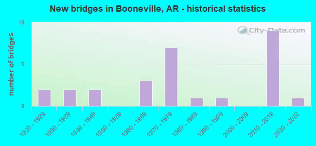
- New bridges - historical statistics
- 21920-1929
- 21930-1939
- 21940-1949
- 31960-1969
- 71970-1979
- 11980-1989
- 11990-1999
- 92010-2019
- 12020-2022

- Reconstructed bridges - Historical Statistics
- 11960-1969
- 01970-1979
- 31980-1989


- Bridge Condition - Deck
- 8.7%Excellent
- 13.0%Very good
- 21.7%Good
- 34.8%Satisfactory
- 17.4%Fair
- 4.3%Serious

- Bridge Condition - Superstructure
- 4.3%Excellent
- 34.8%Very good
- 8.7%Good
- 17.4%Satisfactory
- 17.4%Fair
- 13.0%Poor
- 4.3%Serious

- Bridge Condition - Substructure
- 4.3%Excellent
- 26.1%Very good
- 13.0%Good
- 30.4%Satisfactory
- 21.7%Fair
- 4.3%Poor

- Bridge Condition - Channel
- 13.0%Excellent
- 4.3%Very good
- 47.8%Good
- 26.1%Satisfactory
- 8.7%Fair

- Bridge Condition - Culverts
- 60.0%Good
- 40.0%Satisfactory
Find on map >> Show street view
Structure Number: 2514, Location: 0.35 N OF CAROLAN (Lat: 35.094228, Lng: -93.967378), Route carried "on" structure: State highway 23, Year Built: 1949, Status: Open, Structure Length: 3.75m (12.30ft), Average Daily Traffic: 1,700 (year 2018), Truck Traffic: 1%, Average Future Daily Traffic: 2,550 (year 2028), Design Load: H 15, Features Intersected: Fletcher Creek
Minimum Vertical Clearance: 30+ m (98+ ft), Kilometerpoint: 12.888, Lanes on structure: 2, Base Highway Network: Yes, Owner: State Highway Agency, Approaching Roadway Width: 8.5m (27.9ft), Material/Design: Steel, Design/Construction: Stringer/Multi-beam, Number Of Spans In Main Unit: 4, Length of Maximum Span: 9.1m (29.9ft), Curb or Sidewalk Widths: Left: 0.3m (1.0ft), Right: 0.3m (1.0ft), Curb-To-Curb Width: 7.3m (24.0ft), Out-to-Out Width: 8.1m (26.6ft)
Condition: Deck: Satisfactory, Superstructure: Fair, Substructure: Satisfactory, Channel: Satisfactory, Operating Rating: 51.7 metric tons, Method Used To Determine Operating Rating: Load Factor (LF), Inventory Rating: 30.8 metric tons, Method Used To Determine Inventory Rating: Load Factor (LF), Structural Evaluation: Somewhat better than minimum adequacy, Deck Geometry: Meets minimum limits, Waterway Adequacy: Better than present minimum criteria, Approach Roadway Alignment: Better than present minimum criteria, Length Of Structure Improvement: 4.60m (15.09ft), Designated Inspection Frequency: Every 24 months, Critical Feature Inspection Frequency: Every 24 months, Inspection Date: April 2020, Roadway Improvement Cost: $156,000, Total Project Cost: $502,000, Deck Structure Type: Concrete Cast-file-Place, Wearing Surface/Protective System: Wearing Surface: Bituminous
Find on map >> Show street view
Structure Number: 3368, Location: 0.61 MI N JCT SH 23 & 116 (Lat: 35.114489, Lng: -93.923711), Route carried "on" structure: State highway 23, Year Built: 1961, Status: Open, Structure Length: 16.46m (54.00ft), Average Daily Traffic: 2,900 (year 2018), Truck Traffic: 7%, Average Future Daily Traffic: 3,893 (year 2028), Design Load: H 20, Features Intersected: Petit Jean River Relief
Minimum Vertical Clearance: 30+ m (98+ ft), Kilometerpoint: 0.982, Lanes on structure: 2, Base Highway Network: Yes, Owner: State Highway Agency, Approaching Roadway Width: 9.8m (32.2ft), Material/Design: Concrete, Design/Construction: Slab, Number Of Spans In Main Unit: 18, Length of Maximum Span: 9.1m (29.9ft), Curb or Sidewalk Widths: Left: 0.5m (1.6ft), Right: 0.5m (1.6ft), Curb-To-Curb Width: 8.5m (27.9ft), Out-to-Out Width: 10.3m (33.8ft)
Condition: Deck: Serious, Superstructure: Serious, Substructure: Poor, Channel: Good, Operating Rating: 54.4 metric tons, Method Used To Determine Operating Rating: Load Factor (LF), Inventory Rating: 32.7 metric tons, Method Used To Determine Inventory Rating: Load Factor (LF), Structural Evaluation: High priority of corrective action, Deck Geometry: Meets minimum limits, Waterway Adequacy: Equal to present desirable criteria, Approach Roadway Alignment: Equal to present desirable criteria, Designated Inspection Frequency: Every 24 months, Critical Feature Inspection Frequency: Every 24 months, Other Special Inspection Frequency: Every 24 months, Inspection Date: June 2020, Other Special Inspection Date: May 2021, Deck Structure Type: Concrete Cast-file-Place, Wearing Surface/Protective System: Wearing Surface: Monolithic Concrete
Find on map >> Show street view
Structure Number: 4443, Location: 0.98 MI W SH 23 (Lat: 35.116608, Lng: -93.938500), Route carried "on" structure: County highway 11, Year Built: 1983, Status: Open, Structure Length: 5.91m (19.39ft), Average Daily Traffic: 70 (year 2018), Truck Traffic: 1%, Average Future Daily Traffic: 137 (year 2007), Design Load: H 15, Features Intersected: Petit Jean River, Facility Carried by Structure: Carolan Road
Minimum Vertical Clearance: 30+ m (98+ ft), Kilometerpoint: 4.376, Lanes on structure: 2, Owner: County Highway Agency, Approaching Roadway Width: 8.5m (27.9ft), Material/Design: Steel, Design/Construction: Stringer/Multi-beam, Number Of Spans In Main Unit: 3, Length of Maximum Span: 19.5m (64.0ft), Curb-To-Curb Width: 7.3m (24.0ft), Out-to-Out Width: 8.2m (26.9ft)
Condition: Deck: Good, Superstructure: Good, Substructure: Good, Channel: Good, Operating Rating: 43.5 metric tons, Method Used To Determine Operating Rating: Load Factor (LF), Inventory Rating: 26.3 metric tons, Method Used To Determine Inventory Rating: Load Factor (LF), Structural Evaluation: Equal to present minimum criteria, Deck Geometry: Equal to present minimum criteria, Waterway Adequacy: Equal to present desirable criteria, Approach Roadway Alignment: Equal to present minimum criteria, Designated Inspection Frequency: Every 24 months, Critical Feature Inspection Frequency: Every 24 months, Inspection Date: December 2020, Deck Structure Type: Concrete Cast-file-Place, Wearing Surface/Protective System: Wearing Surface: Monolithic Concrete
Find on map >> Show street view
Structure Number: 5565, Location: 1.2 MI SE JCT SH 23 & 217 (Lat: 35.123069, Lng: -93.899769), Route carried "on" structure: State highway 217, Year Built: 1977, Status: Open, Structure Length: 17.74m (58.20ft), Average Daily Traffic: 730 (year 2018), Truck Traffic: 1%, Average Future Daily Traffic: 1,289 (year 2028), Design Load: H 20, Features Intersected: Petit Jean River
Minimum Vertical Clearance: 30+ m (98+ ft), Kilometerpoint: 14.642, Lanes on structure: 2, Owner: State Highway Agency, Approaching Roadway Width: 8.5m (27.9ft), Skew: 2 degrees, Material/Design: Steel, Design/Construction: Stringer/Multi-beam, Number Of Spans In Main Unit: 11, Length of Maximum Span: 24.4m (80.1ft), Curb-To-Curb Width: 7.9m (25.9ft), Out-to-Out Width: 8.7m (28.5ft)
Condition: Deck: Satisfactory, Superstructure: Good, Substructure: Satisfactory, Channel: Good, Operating Rating: 43.5 metric tons, Method Used To Determine Operating Rating: Load Factor (LF), Inventory Rating: 26.3 metric tons, Method Used To Determine Inventory Rating: Load Factor (LF), Structural Evaluation: Equal to present minimum criteria, Deck Geometry: Somewhat better than minimum adequacy, Waterway Adequacy: Equal to present desirable criteria, Approach Roadway Alignment: Better than present minimum criteria, Designated Inspection Frequency: Every 24 months, Critical Feature Inspection Frequency: Every 24 months, Inspection Date: July 2020, Deck Structure Type: Concrete Cast-file-Place, Wearing Surface/Protective System: Wearing Surface: Monolithic Concrete
Find on map >> Show street view
Structure Number: 7133, Location: 0.43 M. WEST OF 67 & 371 (Lat: 33.797486, Lng: -93.387733), Route carried "on" structure: US 371, Year Built: 2010, Status: Open, Structure Length: 10.30m (33.79ft), Average Daily Traffic: 1,700 (year 2018), Truck Traffic: 18%, Average Future Daily Traffic: 1,900 (year 2038), Design Load: HL 93, Features Intersected: U.S. 67 & UNION P. R/R
Minimum Vertical Clearance: 30+ m (98+ ft), Kilometerpoint: 0.338, Lanes on structure: 2, Lanes under structure: 2, Owner: State Highway Agency, Approaching Roadway Width: 12.2m (40.0ft), Material/Design: Steel continuous, Design/Construction: Stringer/Multi-beam, Number Of Spans In Main Unit: 4, Length of Maximum Span: 30.5m (100.1ft), Curb-To-Curb Width: 12.2m (40.0ft), Out-to-Out Width: 13.2m (43.3ft)
Condition: Deck: Good, Superstructure: Very good, Substructure: Very good, Operating Rating: 54.4 metric tons, Method Used To Determine Operating Rating: Load Factor (LF), Inventory Rating: 32.7 metric tons, Method Used To Determine Inventory Rating: Load Factor (LF), Structural Evaluation: Equal to present desirable criteria, Deck Geometry: Better than present minimum criteria, Underclear: Superior to present desirable criteria, Approach Roadway Alignment: Better than present minimum criteria, Designated Inspection Frequency: Every 24 months, Critical Feature Inspection Frequency: Every 24 months, Inspection Date: October 2020, Deck Structure Type: Concrete Cast-file-Place, Wearing Surface/Protective System: Wearing Surface: Monolithic Concrete, Deck Protection: Epoxy Coated Reinforcing
Find on map >> Show street view
Structure Number: 7191, Location: Jct I-430/I-630 (Lat: 34.746600, Lng: -92.390611), Route carried "on" structure: Ramp Interstate 430, Year Built: 2015, Status: Open, Structure Length: 29.87m (98.00ft), Average Daily Traffic: 1,700 (year 2018), Truck Traffic: 15%, Average Future Daily Traffic: 33,000 (year 2028), Design Load: HL 93, Features Intersected: I-630 Log 7.30
Minimum Vertical Clearance: 30+ m (98+ ft), Kilometerpoint: 9.656, Lanes on structure: 2, Lanes under structure: 5, Base Highway Network: Yes (, Subroute: 10), Owner: State Highway Agency, Approaching Roadway Width: 7.3m (24.0ft), Skew: 2 degrees, Material/Design: Steel continuous, Design/Construction: Stringer/Multi-beam, Number Of Spans In Main Unit: 7, Length of Maximum Span: 70.7m (232.0ft), Curb-To-Curb Width: 7.3m (24.0ft), Out-to-Out Width: 13.2m (43.3ft)
Condition: Deck: Very good, Superstructure: Very good, Substructure: Very good, Operating Rating: 46.3 metric tons, Method Used To Determine Operating Rating: Load and Resistance Factor (LRFR), Inventory Rating: 32.7 metric tons, Method Used To Determine Inventory Rating: Load and Resistance Factor (LRFR), Structural Evaluation: Equal to present desirable criteria, Deck Geometry: High priority of replacement, Approach Roadway Alignment: Equal to present desirable criteria, Designated Inspection Frequency: Every 24 months, Critical Feature Inspection Frequency: Every 24 months, Inspection Date: Febuary 2021, Deck Structure Type: Concrete Cast-file-Place, Wearing Surface/Protective System: Wearing Surface: Monolithic Concrete, Deck Protection: Epoxy Coated Reinforcing
Find on map >> Show street view
Structure Number: 7192, Location: 7.10 mile west I-30 (Lat: 34.748389, Lng: -92.386561), Route carried "on" structure: Ramp Interstate 630, Year Built: 2014, Status: Open, Structure Length: 56.05m (183.89ft), Average Daily Traffic: 15,000 (year 2018), Truck Traffic: 15%, Average Future Daily Traffic: 10,000 (year 2018), Design Load: HL 93, Features Intersected: I-630 EB & I-430
Minimum Vertical Clearance: 30+ m (98+ ft), Kilometerpoint: 11.426, Lanes on structure: 2, Lanes under structure: 16, Base Highway Network: Yes (Inventory Route: 6, Subroute: 10), Owner: State Highway Agency, Approaching Roadway Width: 12.2m (40.0ft), Skew: 4 degrees, Material/Design: Steel continuous, Design/Construction: Stringer/Multi-beam, Number Of Spans In Main Unit: 11, Length of Maximum Span: 151.5m (497.0ft), Curb-To-Curb Width: 13.4m (44.0ft), Out-to-Out Width: 14.4m (47.2ft)
Condition: Deck: Very good, Superstructure: Very good, Substructure: Good, Operating Rating: 42.6 metric tons, Method Used To Determine Operating Rating: Load and Resistance Factor (LRFR), Inventory Rating: 32.7 metric tons, Method Used To Determine Inventory Rating: Load and Resistance Factor (LRFR), Structural Evaluation: Better than present minimum criteria, Deck Geometry: Superior to present desirable criteria, Underclear: High priority of corrective action, Approach Roadway Alignment: Equal to present minimum criteria, Designated Inspection Frequency: Every 24 months, Critical Feature Inspection Frequency: Every 24 months, Inspection Date: June 2021, Deck Structure Type: Concrete Cast-file-Place, Wearing Surface/Protective System: Wearing Surface: Monolithic Concrete, Deck Protection: Epoxy Coated Reinforcing
Find on map >> Show street view
Structure Number: 7202, Location: 6.18 Mi So. JCT Hwy 27 (Lat: 35.840619, Lng: -92.577039), Route carried "on" structure: US 65, Year Built: 2012, Status: Open, Structure Length: 5.52m (18.11ft), Average Daily Traffic: 5,900 (year 2018), Truck Traffic: 16%, Average Future Daily Traffic: 8,000 (year 2031), Design Load: HL 93, Features Intersected: Cove Creek
Minimum Vertical Clearance: 30+ m (98+ ft), Kilometerpoint: 9.946, Lanes on structure: 2, Owner: State Highway Agency, Approaching Roadway Width: 12.2m (40.0ft), Material/Design: Steel continuous, Design/Construction: Stringer/Multi-beam, Number Of Spans In Main Unit: 3, Length of Maximum Span: 21.3m (69.9ft), Curb-To-Curb Width: 12.2m (40.0ft), Out-to-Out Width: 13.0m (42.7ft)
Condition: Deck: Good, Superstructure: Very good, Substructure: Good, Channel: Excellent, Operating Rating: 36.3 metric tons, Method Used To Determine Operating Rating: Load and Resistance Factor (LRFR), Inventory Rating: 28.1 metric tons, Method Used To Determine Inventory Rating: Load and Resistance Factor (LRFR), Structural Evaluation: Better than present minimum criteria, Deck Geometry: Somewhat better than minimum adequacy, Waterway Adequacy: Equal to present desirable criteria, Approach Roadway Alignment: Equal to present desirable criteria, Designated Inspection Frequency: Every 24 months, Critical Feature Inspection Frequency: Every 24 months, Inspection Date: June 2020, Deck Structure Type: Concrete Cast-file-Place, Wearing Surface/Protective System: Wearing Surface: Monolithic Concrete, Deck Protection: Epoxy Coated Reinforcing
Find on map >> Show street view
Structure Number: 7278, Location: 0.21Mi W US 71B (Lat: 36.415000, Lng: -94.224306), Route carried "on" structure: State highway 49, Year Built: 2021, Status: Open, Structure Length: 15.09m (49.51ft), Average Daily Traffic: 6,100 (year 2020), Average Future Daily Traffic: 7,320 (year 2040), Design Load: HL 93, Features Intersected: McKisic Creek
Minimum Vertical Clearance: 30.17m (98.98ft), Kilometerpoint: 147.646, Lanes on structure: 4, Base Highway Network: Yes, Owner: State Highway Agency, Approaching Roadway Width: 13.4m (44.0ft), Skew: 30 degrees, Material/Design: Steel continuous, Design/Construction: Stringer/Multi-beam, Number Of Spans In Main Unit: 6, Length of Maximum Span: 30.5m (100.1ft), Curb-To-Curb Width: 13.4m (44.0ft), Out-to-Out Width: 28.7m (94.2ft)
Condition: Deck: Good, Superstructure: Very good, Substructure: Very good, Channel: Excellent, Operating Rating: 53.5 metric tons, Method Used To Determine Operating Rating: Load and Resistance Factor (LRFR), Inventory Rating: 32.7 metric tons, Method Used To Determine Inventory Rating: Load and Resistance Factor (LRFR), Structural Evaluation: Equal to present desirable criteria, Deck Geometry: High priority of replacement, Waterway Adequacy: Superior to present desirable criteria, Approach Roadway Alignment: Equal to present desirable criteria, Designated Inspection Frequency: Every 24 months, Critical Feature Inspection Frequency: Every 24 months, Inspection Date: August 2021, Deck Structure Type: Concrete Cast-file-Place, Wearing Surface/Protective System: Deck Protection: Epoxy Coated Reinforcing
Find on map >> Show street view
Structure Number: 7279, Location: 0.21 Mi US 71 B (Lat: 36.415100, Lng: -94.225997), Route carried "on" structure: Ramp State highway 49, Year Built: 2014, Status: Open, Structure Length: 13.87m (45.51ft), Average Daily Traffic: 5,700 (year 2018), Truck Traffic: 5%, Average Future Daily Traffic: 2,800 (year 2034), Design Load: HL 93, Features Intersected: McKisic Creek
Minimum Vertical Clearance: 30.17m (98.98ft), Kilometerpoint: 0.338, Lanes on structure: 2, Owner: State Highway Agency, Approaching Roadway Width: 12.2m (40.0ft), Material/Design: Steel continuous, Design/Construction: Stringer/Multi-beam, Number Of Spans In Main Unit: 6, Length of Maximum Span: 51.8m (169.9ft), Curb-To-Curb Width: 12.1m (39.7ft), Out-to-Out Width: 13.1m (43.0ft)
Condition: Deck: Excellent, Superstructure: Very good, Substructure: Excellent, Channel: Good, Operating Rating: 54.4 metric tons, Method Used To Determine Operating Rating: Load and Resistance Factor (LRFR), Inventory Rating: 32.7 metric tons, Method Used To Determine Inventory Rating: Load and Resistance Factor (LRFR), Structural Evaluation: Equal to present desirable criteria, Deck Geometry: Superior to present desirable criteria, Waterway Adequacy: Superior to present desirable criteria, Approach Roadway Alignment: Equal to present desirable criteria, Designated Inspection Frequency: Every 24 months, Critical Feature Inspection Frequency: Every 24 months, Inspection Date: June 2021, Deck Structure Type: Concrete Cast-file-Place, Wearing Surface/Protective System: Deck Protection: Epoxy Coated Reinforcing
Find on map >> Show street view
Structure Number: 7294, Location: S. of AR River (Lat: 34.750119, Lng: -92.275569), Route carried "on" structure: Ramp State highway 10, Year Built: 2017, Status: Open, Structure Length: 6.89m (22.60ft), Average Daily Traffic: 3,300 (year 2018), Truck Traffic: 1%, Average Future Daily Traffic: 30,126 (year 2033), Design Load: HL 93, Features Intersected: Arch Street-District 6
Minimum Vertical Clearance: 30+ m (98+ ft), Kilometerpoint: 0.080, Lanes on structure: 1, Owner: State Highway Agency, Approaching Roadway Width: 9.4m (30.8ft), Material/Design: Steel continuous, Design/Construction: Stringer/Multi-beam, Number Of Spans In Main Unit: 3, Length of Maximum Span: 22.9m (75.1ft), Curb or Sidewalk Widths: Left: 0.5m (1.6ft), Right: 0.5m (1.6ft), Curb-To-Curb Width: 9.4m (30.8ft), Out-to-Out Width: 10.4m (34.1ft)
Condition: Deck: Very good, Superstructure: Very good, Substructure: Very good, Operating Rating: 54.4 metric tons, Method Used To Determine Operating Rating: Load and Resistance Factor (LRFR), Inventory Rating: 32.7 metric tons, Method Used To Determine Inventory Rating: Load and Resistance Factor (LRFR), Structural Evaluation: Equal to present desirable criteria, Deck Geometry: Superior to present desirable criteria, Approach Roadway Alignment: Equal to present minimum criteria, Designated Inspection Frequency: Every 24 months, Critical Feature Inspection Frequency: Every 24 months, Inspection Date: March 2020, Deck Structure Type: Concrete Cast-file-Place, Wearing Surface/Protective System: Wearing Surface: Monolithic Concrete, Deck Protection: Epoxy Coated Reinforcing
Find on map >> Show street view
Structure Number: 7316, Location: 0.36 MI E JCT US 67 (Lat: 34.120781, Lng: -93.046969), Route carried "on" structure: State highway 51, Year Built: 2018, Status: Open, Structure Length: 49.66m (162.93ft), Average Daily Traffic: 3,719 (year 2018), Truck Traffic: 10%, Average Future Daily Traffic: 6,000 (year 2034), Design Load: HL 93, Features Intersected: OUACHITA RIVER
Minimum Vertical Clearance: 30+ m (98+ ft), Kilometerpoint: 0.579, Lanes on structure: 2, Base Highway Network: Yes, Owner: State Highway Agency, Approaching Roadway Width: 12.2m (40.0ft), Skew: 3 degrees, Material/Design: Steel continuous, Design/Construction: Stringer/Multi-beam, Number Of Spans In Main Unit: 4, Number Of Approach Spans: 6, Length of Maximum Span: 73.2m (240.2ft), Curb-To-Curb Width: 12.2m (40.0ft), Out-to-Out Width: 13.0m (42.7ft)
Condition: Deck: Good, Superstructure: Excellent, Substructure: Very good, Channel: Excellent, Operating Rating: 54.4 metric tons, Method Used To Determine Operating Rating: Load and Resistance Factor (LRFR), Inventory Rating: 32.7 metric tons, Method Used To Determine Inventory Rating: Load and Resistance Factor (LRFR), Structural Evaluation: Equal to present desirable criteria, Deck Geometry: Equal to present minimum criteria, Underclear: Superior to present desirable criteria, Waterway Adequacy: Superior to present desirable criteria, Approach Roadway Alignment: Equal to present desirable criteria, Designated Inspection Frequency: Every 24 months, Critical Feature Inspection Frequency: Every 24 months, Inspection Date: May 2020, Deck Structure Type: Concrete Cast-file-Place
Find on map >> Show street view
Structure Number: 7317, Location: 1.9 M NW SH 365 (Lat: 34.866858, Lng: -92.361314), Route carried "on" structure: County highway 54, Year Built: 2016, Status: Open, Structure Length: 11.89m (39.01ft), Average Daily Traffic: 850 (year 2018), Truck Traffic: 1%, Average Future Daily Traffic: 200 (year 2036), Design Load: HL 93, Features Intersected: I-40 Sec 33 Log 144.02
Minimum Vertical Clearance: 5.15m (16.90ft), Kilometerpoint: 3.058, Lanes on structure: 2, Lanes under structure: 6, Owner: State Highway Agency, Approaching Roadway Width: 9.1m (29.9ft), Skew: 3 degrees, Material/Design: Steel continuous, Design/Construction: Stringer/Multi-beam, Number Of Spans In Main Unit: 3, Length of Maximum Span: 41.1m (134.8ft), Curb-To-Curb Width: 10.4m (34.1ft), Out-to-Out Width: 11.3m (37.1ft)
Condition: Deck: Excellent, Superstructure: Very good, Substructure: Very good, Operating Rating: 54.4 metric tons, Method Used To Determine Operating Rating: Load and Resistance Factor (LRFR), Inventory Rating: 32.7 metric tons, Method Used To Determine Inventory Rating: Load and Resistance Factor (LRFR), Structural Evaluation: Equal to present desirable criteria, Deck Geometry: Equal to present minimum criteria, Underclear: Equal to present minimum criteria, Approach Roadway Alignment: Equal to present desirable criteria, Designated Inspection Frequency: Every 24 months, Critical Feature Inspection Frequency: Every 24 months, Inspection Date: March 2021, Deck Structure Type: Concrete Cast-file-Place, Wearing Surface/Protective System: Wearing Surface: Monolithic Concrete, Deck Protection: Epoxy Coated Reinforcing
Find on map >> Show street view
Structure Number: 1475, Location: 0.77 MI S SH 10 (Lat: 35.132219, Lng: -93.958050), Route carried "on" structure: County highway 17, Year Built: 1976, Status: Open, Structure Length: 1.49m (4.89ft), Average Daily Traffic: 106 (year 2018), Truck Traffic: 1%, Average Future Daily Traffic: 98 (year 2007), Features Intersected: Racoon Creek-Logan Co., Facility Carried by Structure: Roy Franks Ln.
Minimum Vertical Clearance: 30+ m (98+ ft), Kilometerpoint: 1.223, Lanes on structure: 1, Owner: County Highway Agency, Approaching Roadway Width: 4.9m (16.1ft), Material/Design: Concrete, Design/Construction: Channel Beam, Number Of Spans In Main Unit: 3, Length of Maximum Span: 4.9m (16.1ft), Curb-To-Curb Width: 4.6m (15.1ft), Out-to-Out Width: 4.6m (15.1ft)
Condition: Deck: Fair, Superstructure: Poor, Substructure: Fair, Channel: Satisfactory, Operating Rating: 35.4 metric tons, Method Used To Determine Operating Rating: Allowable Stress (AS), Inventory Rating: 21.8 metric tons, Method Used To Determine Inventory Rating: Allowable Stress (AS), Structural Evaluation: Meets minimum limits, Deck Geometry: High priority of replacement, Waterway Adequacy: Equal to present minimum criteria, Approach Roadway Alignment: Equal to present minimum criteria, Length Of Structure Improvement: 1.49m (4.89ft), Designated Inspection Frequency: Every 24 months, Critical Feature Inspection Frequency: Every 24 months, Other Special Inspection Frequency: Every 24 months, Inspection Date: November 2020, Other Special Inspection Date: November 2021, Total Project Cost: $33,000, Deck Structure Type: Concrete Precast Panels, Wearing Surface/Protective System: Wearing Surface: Monolithic Concrete
Find on map >> Show street view
Structure Number: 14752, Location: 0.02MI W OF CORD S15 I (Lat: 35.142869, Lng: -93.974339), Route carried "on" structure: County highway 24, Year Built: 1940, Year Reconstructed: 1992, Status: Posted for load, Structure Length: 1.13m (3.71ft), Average Daily Traffic: 55 (year 2018), Truck Traffic: 1%, Average Future Daily Traffic: 54 (year 2007), Features Intersected: Creek - Logan Co., Facility Carried by Structure: Mid Valley Rd
Minimum Vertical Clearance: 30+ m (98+ ft), Kilometerpoint: 0.531, Lanes on structure: 2, Owner: County Highway Agency, Approaching Roadway Width: 4.6m (15.1ft), Skew: 3 degrees, Material/Design: Steel continuous, Design/Construction: Stringer/Multi-beam, Number Of Spans In Main Unit: 2, Length of Maximum Span: 5.2m (17.1ft), Curb-To-Curb Width: 6.1m (20.0ft), Out-to-Out Width: 6.1m (20.0ft)
Condition: Deck: Satisfactory, Superstructure: Satisfactory, Substructure: Satisfactory, Channel: Good, Operating Rating: 24.5 metric tons, Method Used To Determine Operating Rating: Load Factor (LF), Inventory Rating: 14.5 metric tons, Method Used To Determine Inventory Rating: Load Factor (LF), Structural Evaluation: Meets minimum limits, Deck Geometry: Somewhat better than minimum adequacy, Waterway Adequacy: Equal to present minimum criteria, Approach Roadway Alignment: Somewhat better than minimum adequacy, Bridge Posting: Required (Relationship of Operating Rating to Maximum Legal Load: 20.0 - 29.9% below), Length Of Structure Improvement: 1.86m (6.10ft), Designated Inspection Frequency: Every 24 months, Critical Feature Inspection Frequency: Every 24 months, Inspection Date: August 2021, Roadway Improvement Cost: $109,000, Total Project Cost: $225,000, Deck Structure Type: Concrete Precast Panels, Wearing Surface/Protective System: Wearing Surface: Monolithic Concrete
Find on map >> Show street view
Structure Number: 14758, Location: 1.55 MI NE SH116 (Lat: 35.172019, Lng: -93.858581), Route carried "on" structure: County highway 28, Year Built: 1975, Status: Posted for load, Structure Length: 0.98m (3.22ft), Average Daily Traffic: 208 (year 2018), Truck Traffic: 1%, Average Future Daily Traffic: 40 (year 2007), Design Load: H 10, Features Intersected: Scotts Creek-Logan Co., Facility Carried by Structure: Cotton Rd - Logan
Minimum Vertical Clearance: 30+ m (98+ ft), Kilometerpoint: 2.478, Lanes on structure: 2, Owner: County Highway Agency, Approaching Roadway Width: 6.4m (21.0ft), Material/Design: Concrete, Design/Construction: Channel Beam, Number Of Spans In Main Unit: 2, Length of Maximum Span: 5.2m (17.1ft), Curb or Sidewalk Widths: Left: 0.2m (0.7ft), Right: 0.2m (0.7ft), Curb-To-Curb Width: 7.1m (23.3ft), Out-to-Out Width: 7.4m (24.3ft)
Condition: Deck: Satisfactory, Superstructure: Fair, Substructure: Fair, Channel: Satisfactory, Operating Rating: 11.8 metric tons, Method Used To Determine Operating Rating: Load Factor (LF), Inventory Rating: 7.3 metric tons, Method Used To Determine Inventory Rating: Load Factor (LF), Structural Evaluation: High priority of corrective action, Deck Geometry: Meets minimum limits, Waterway Adequacy: Equal to present minimum criteria, Approach Roadway Alignment: High priority of corrective action, Bridge Posting: Required (Relationship of Operating Rating to Maximum Legal Load: > 39.9% below), Length Of Structure Improvement: 0.98m (3.22ft), Designated Inspection Frequency: Every 24 months, Critical Feature Inspection Frequency: Every 24 months, Inspection Date: August 2021, Total Project Cost: $34,000, Deck Structure Type: Concrete Precast Panels, Wearing Surface/Protective System: Wearing Surface: Bituminous
Find on map >> Show street view
Structure Number: 18117, Location: 1.51 MI W SH 23 (Lat: 35.130169, Lng: -93.941869), Route carried "on" structure: County highway 16, Year Built: 1970, Status: Open, Structure Length: 1.83m (6.00ft), Average Daily Traffic: 998 (year 2018), Truck Traffic: 1%, Average Future Daily Traffic: 117 (year 2007), Design Load: H 10, Features Intersected: Greasy Creek-Logan Co., Facility Carried by Structure: Barber Road
Minimum Vertical Clearance: 30+ m (98+ ft), Kilometerpoint: 2.430, Lanes on structure: 2, Owner: County Highway Agency, Approaching Roadway Width: 6.1m (20.0ft), Material/Design: Concrete, Design/Construction: Channel Beam, Number Of Spans In Main Unit: 3, Length of Maximum Span: 6.1m (20.0ft), Curb-To-Curb Width: 8.3m (27.2ft), Out-to-Out Width: 8.3m (27.2ft)
Condition: Deck: Fair, Superstructure: Poor, Substructure: Fair, Channel: Satisfactory, Operating Rating: 15.4 metric tons, Method Used To Determine Operating Rating: Load Factor (LF), Inventory Rating: 10.0 metric tons, Method Used To Determine Inventory Rating: Load Factor (LF), Structural Evaluation: High priority of corrective action, Deck Geometry: Somewhat better than minimum adequacy, Waterway Adequacy: Equal to present minimum criteria, Approach Roadway Alignment: Equal to present desirable criteria, Bridge Posting: Required (Relationship of Operating Rating to Maximum Legal Load: > 39.9% below), Length Of Structure Improvement: 1.83m (6.00ft), Designated Inspection Frequency: Every 24 months, Critical Feature Inspection Frequency: Every 24 months, Inspection Date: August 2020, Total Project Cost: $73,000, Deck Structure Type: Concrete Precast Panels, Wearing Surface/Protective System: Wearing Surface: Monolithic Concrete
Find on map >> Show street view
Structure Number: 18118, Location: 2.32 W BOONEVILLE (Lat: 35.131169, Lng: -93.955550), Route carried "on" structure: County highway 16, Year Built: 1970, Status: Open, Structure Length: 1.22m (4.00ft), Average Daily Traffic: 998 (year 2018), Truck Traffic: 1%, Average Future Daily Traffic: 117 (year 2007), Design Load: H 15, Features Intersected: Racoon Creek-Logan Co., Facility Carried by Structure: Barber Road
Minimum Vertical Clearance: 30+ m (98+ ft), Kilometerpoint: 3.734, Lanes on structure: 2, Owner: County Highway Agency, Approaching Roadway Width: 5.5m (18.0ft), Material/Design: Concrete, Design/Construction: Channel Beam, Number Of Spans In Main Unit: 2, Length of Maximum Span: 6.1m (20.0ft), Curb or Sidewalk Widths: Left: 0.2m (0.7ft), Right: 0.2m (0.7ft), Curb-To-Curb Width: 5.3m (17.4ft), Out-to-Out Width: 5.6m (18.4ft)
Condition: Deck: Satisfactory, Superstructure: Fair, Substructure: Fair, Channel: Good, Operating Rating: 32.7 metric tons, Method Used To Determine Operating Rating: Load Factor (LF), Inventory Rating: 20.0 metric tons, Method Used To Determine Inventory Rating: Load Factor (LF), Structural Evaluation: Somewhat better than minimum adequacy, Deck Geometry: High priority of replacement, Waterway Adequacy: Equal to present minimum criteria, Approach Roadway Alignment: High priority of corrective action, Length Of Structure Improvement: 1.95m (6.40ft), Designated Inspection Frequency: Every 24 months, Critical Feature Inspection Frequency: Every 24 months, Inspection Date: August 2021, Roadway Improvement Cost: $109,000, Total Project Cost: $229,000, Deck Structure Type: Concrete Precast Panels, Wearing Surface/Protective System: Wearing Surface: Monolithic Concrete
Find on map >> Show street view
Structure Number: 19253, Location: 0.25 E SH 23 (Lat: 35.144969, Lng: -93.916897), Route carried "on" structure: City street 64574, Year Built: 1960, Status: Posted for load, Structure Length: 1.22m (4.00ft), Average Daily Traffic: 781 (year 2018), Truck Traffic: 1%, Average Future Daily Traffic: 752 (year 2007), Features Intersected: Booneville Creek-Logan, Facility Carried by Structure: E. 8th Street
Minimum Vertical Clearance: 30+ m (98+ ft), Kilometerpoint: 0.402, Lanes on structure: 2, Owner: City or Municipal Highway Agency, Approaching Roadway Width: 6.4m (21.0ft), Material/Design: Concrete, Design/Construction: Channel Beam, Number Of Spans In Main Unit: 2, Length of Maximum Span: 6.1m (20.0ft), Curb or Sidewalk Widths: Left: 0.0m, Right: 1.4m (4.6ft), Curb-To-Curb Width: 7.2m (23.6ft), Out-to-Out Width: 9.2m (30.2ft)
Condition: Deck: Fair, Superstructure: Poor, Substructure: Satisfactory, Channel: Good, Operating Rating: 29.9 metric tons, Method Used To Determine Operating Rating: Load Factor (LF), Inventory Rating: 18.1 metric tons, Method Used To Determine Inventory Rating: Load Factor (LF), Structural Evaluation: Meets minimum limits, Deck Geometry: Meets minimum limits, Waterway Adequacy: Better than present minimum criteria, Approach Roadway Alignment: Equal to present minimum criteria, Bridge Posting: Required (Relationship of Operating Rating to Maximum Legal Load: 10.0 - 19.9% below), Designated Inspection Frequency: Every 24 months, Critical Feature Inspection Frequency: Every 24 months, Inspection Date: April 2021, Deck Structure Type: Concrete Precast Panels, Wearing Surface/Protective System: Wearing Surface: Bituminous
Find on map >> Show street view
Structure Number: 19254, Location: 0.21 EAST SH 217 (Lat: 35.134278, Lng: -93.910889), Route carried "on" structure: City street 25656, Year Built: 1966, Status: Open, Structure Length: 1.22m (4.00ft), Average Daily Traffic: 146 (year 2018), Truck Traffic: 1%, Average Future Daily Traffic: 129 (year 2007), Design Load: H 15, Features Intersected: Booneville Creek, Facility Carried by Structure: Helton Rd-Logan Co
Minimum Vertical Clearance: 30+ m (98+ ft), Kilometerpoint: 0.338, Lanes on structure: 1, Owner: City or Municipal Highway Agency, Approaching Roadway Width: 5.5m (18.0ft), Material/Design: Concrete, Design/Construction: Channel Beam, Number Of Spans In Main Unit: 2, Length of Maximum Span: 6.1m (20.0ft), Curb-To-Curb Width: 4.6m (15.1ft), Out-to-Out Width: 4.6m (15.1ft)
Condition: Deck: Satisfactory, Superstructure: Satisfactory, Substructure: Satisfactory, Channel: Satisfactory, Operating Rating: 38.1 metric tons, Method Used To Determine Operating Rating: Load Factor (LF), Inventory Rating: 22.7 metric tons, Method Used To Determine Inventory Rating: Load Factor (LF), Structural Evaluation: Equal to present minimum criteria, Deck Geometry: High priority of replacement, Waterway Adequacy: High priority of corrective action, Approach Roadway Alignment: High priority of corrective action, Length Of Structure Improvement: 1.22m (4.00ft), Designated Inspection Frequency: Every 24 months, Critical Feature Inspection Frequency: Every 24 months, Inspection Date: December 2020, Total Project Cost: $26,000, Deck Structure Type: Concrete Precast Panels, Wearing Surface/Protective System: Wearing Surface: Monolithic Concrete
Find on map >> Show street view
Structure Number: 19255, Location: 0.14 N 8TH ST (Lat: 35.146997, Lng: -93.919306), Route carried "on" structure: City street 10965, Year Built: 1979, Status: Posted for load, Structure Length: 1.22m (4.00ft), Average Daily Traffic: 209 (year 2018), Truck Traffic: 1%, Average Future Daily Traffic: 54 (year 2007), Design Load: H 15, Features Intersected: Booneville Creek-Logan, Facility Carried by Structure: N. Chismville Road
Minimum Vertical Clearance: 30+ m (98+ ft), Kilometerpoint: 0.225, Lanes on structure: 2, Owner: City or Municipal Highway Agency, Approaching Roadway Width: 5.5m (18.0ft), Skew: 3 degrees, Material/Design: Concrete, Design/Construction: Slab, Number Of Spans In Main Unit: 2, Length of Maximum Span: 6.4m (21.0ft), Curb or Sidewalk Widths: Left: 0.3m (1.0ft), Right: 1.4m (4.6ft), Curb-To-Curb Width: 7.5m (24.6ft), Out-to-Out Width: 9.1m (29.9ft)
Condition: Deck: Fair, Superstructure: Fair, Substructure: Fair, Channel: Good, Operating Rating: 12.7 metric tons, Method Used To Determine Operating Rating: Load Factor (LF), Inventory Rating: 8.2 metric tons, Method Used To Determine Inventory Rating: Load Factor (LF), Structural Evaluation: High priority of corrective action, Deck Geometry: Somewhat better than minimum adequacy, Waterway Adequacy: Better than present minimum criteria, Approach Roadway Alignment: Equal to present minimum criteria, Bridge Posting: Required (Relationship of Operating Rating to Maximum Legal Load: > 39.9% below), Length Of Structure Improvement: 1.22m (4.00ft), Designated Inspection Frequency: Every 24 months, Critical Feature Inspection Frequency: Every 24 months, Inspection Date: April 2021, Total Project Cost: $53,000, Deck Structure Type: Concrete Cast-file-Place, Wearing Surface/Protective System: Wearing Surface: Monolithic Concrete
Find on map >> Show street view
Structure Number: 23707, Location: 0.78 Mi. N of Barber Road (Lat: 35.141536, Lng: -93.973739), Route carried "on" structure: County highway 515, Year Built: 2014, Status: Open, Structure Length: 0.99m (3.25ft), Average Daily Traffic: 80 (year 2013), Truck Traffic: 3%, Average Future Daily Traffic: 150 (year 2033), Design Load: HL 93, Features Intersected: Raccoon Creek-Logan Co., Facility Carried by Structure: Lyles Chapel Road
Minimum Vertical Clearance: 30+ m (98+ ft), Kilometerpoint: 1.255, Lanes on structure: 2, Owner: County Highway Agency, Approaching Roadway Width: 6.1m (20.0ft), Material/Design: Concrete, Design/Construction: Culvert, Number Of Spans In Main Unit: 5, Length of Maximum Span: 2.0m (6.6ft), Curb or Sidewalk Widths: Left: 0.3m (1.0ft), Right: 0.3m (1.0ft), Curb-To-Curb Width: 11.6m (38.1ft), Out-to-Out Width: 12.2m (40.0ft)
Condition: Channel: Very good, Culverts: Good, Operating Rating: 33.6 metric tons, Method Used To Determine Operating Rating: Load Factor (LF), Inventory Rating: 20.9 metric tons, Method Used To Determine Inventory Rating: Load Factor (LF), Structural Evaluation: Equal to present minimum criteria, Deck Geometry: Superior to present desirable criteria, Waterway Adequacy: Equal to present minimum criteria, Approach Roadway Alignment: Equal to present desirable criteria, Designated Inspection Frequency: Every 24 months, Critical Feature Inspection Frequency: Every 24 months, Inspection Date: March 2020
Find on map >> Show street view
Structure Number: A0704, Location: 5.50 MI E SEBASTIAN CO LI (Lat: 35.141950, Lng: -93.946308), Route carried "on" structure: State highway 10, Year Built: 1928, Year Reconstructed: 1967, Status: Open, Structure Length: 2.19m (7.19ft), Average Daily Traffic: 3,800 (year 2018), Truck Traffic: 5%, Average Future Daily Traffic: 4,200 (year 2038), Design Load: H 20, Features Intersected: Greasy Creek - Logan Co.
Minimum Vertical Clearance: 30+ m (98+ ft), Kilometerpoint: 8.850, Lanes on structure: 2, Base Highway Network: Yes, Owner: State Highway Agency, Approaching Roadway Width: 10.4m (34.1ft), Material/Design: Concrete, Design/Construction: Tee Beam, Number Of Spans In Main Unit: 2, Length of Maximum Span: 10.7m (35.1ft), Curb-To-Curb Width: 8.5m (27.9ft), Out-to-Out Width: 9.7m (31.8ft)
Condition: Deck: Satisfactory, Superstructure: Satisfactory, Substructure: Satisfactory, Channel: Good, Operating Rating: 41.7 metric tons, Method Used To Determine Operating Rating: Load Factor (LF), Inventory Rating: 24.5 metric tons, Method Used To Determine Inventory Rating: Load Factor (LF), Structural Evaluation: Equal to present minimum criteria, Deck Geometry: Meets minimum limits, Waterway Adequacy: Equal to present desirable criteria, Approach Roadway Alignment: Equal to present desirable criteria, Designated Inspection Frequency: Every 24 months, Critical Feature Inspection Frequency: Every 24 months, Inspection Date: June 2020, Deck Structure Type: Concrete Cast-file-Place, Wearing Surface/Protective System: Wearing Surface: Bituminous
Find on map >> Show street view
Structure Number: A1274, Location: 0.5 MI E JCT SH 23 (Lat: 35.139969, Lng: -93.915039), Route carried "on" structure: State highway 10, Year Built: 1930, Year Reconstructed: 1980, Status: Open, Structure Length: 3.29m (10.79ft), Average Daily Traffic: 10,000 (year 2018), Truck Traffic: 6%, Average Future Daily Traffic: 11,000 (year 2038), Design Load: H 20, Features Intersected: Booneville Creek
Minimum Vertical Clearance: 30+ m (98+ ft), Kilometerpoint: 11.779, Lanes on structure: 2, Base Highway Network: Yes, Owner: State Highway Agency, Approaching Roadway Width: 17.7m (58.1ft), Material/Design: Concrete, Design/Construction: Tee Beam, Number Of Spans In Main Unit: 3, Length of Maximum Span: 10.7m (35.1ft), Curb or Sidewalk Widths: Left: 1.2m (3.9ft), Right: 1.2m (3.9ft), Curb-To-Curb Width: 15.2m (49.9ft), Out-to-Out Width: 18.3m (60.0ft)
Condition: Deck: Satisfactory, Superstructure: Satisfactory, Substructure: Satisfactory, Channel: Good, Operating Rating: 49.0 metric tons, Method Used To Determine Operating Rating: Load Factor (LF), Inventory Rating: 29.0 metric tons, Method Used To Determine Inventory Rating: Load Factor (LF), Structural Evaluation: Equal to present minimum criteria, Deck Geometry: Superior to present desirable criteria, Waterway Adequacy: Equal to present desirable criteria, Approach Roadway Alignment: Equal to present desirable criteria, Length Of Structure Improvement: 3.29m (10.79ft), Designated Inspection Frequency: Every 24 months, Critical Feature Inspection Frequency: Every 24 months, Inspection Date: June 2020, Total Project Cost: $289,000, Deck Structure Type: Concrete Cast-file-Place, Wearing Surface/Protective System: Wearing Surface: Bituminous
Find on map >> Show street view
Structure Number: M0301, Location: 0.2 MI NW OF JCT SH 60 (Lat: 35.149889, Lng: -93.986750), Route carried "on" structure: State highway 10, Year Built: 1928, Year Reconstructed: 1985, Status: Open, Structure Length: 0.61m (2.00ft), Average Daily Traffic: 2,800 (year 2018), Truck Traffic: 1%, Average Future Daily Traffic: 4,698 (year 2028), Design Load: H 15, Features Intersected: Ditch-Logan Co.
Minimum Vertical Clearance: 30+ m (98+ ft), Kilometerpoint: 4.987, Lanes on structure: 2, Base Highway Network: Yes, Owner: State Highway Agency, Approaching Roadway Width: 10.4m (34.1ft), Material/Design: Concrete, Design/Construction: Culvert, Number Of Spans In Main Unit: 2, Length of Maximum Span: 3.0m (9.8ft)
Condition: Channel: Good, Culverts: Good, Operating Rating: 35.4 metric tons, Method Used To Determine Operating Rating: Load Factor (LF), Inventory Rating: 21.8 metric tons, Method Used To Determine Inventory Rating: Load Factor (LF), Structural Evaluation: Somewhat better than minimum adequacy, Waterway Adequacy: Equal to present desirable criteria, Approach Roadway Alignment: Equal to present desirable criteria, Designated Inspection Frequency: Every 24 months, Critical Feature Inspection Frequency: Every 24 months, Inspection Date: June 2020
Find on map >> Show street view
Structure Number: M0541, Location: 0.6 mi N Jct Hwy 10 (Lat: 35.148678, Lng: -93.921189), Route carried "on" structure: State highway 23, Year Built: 1930, Status: Open, Structure Length: 0.98m (3.22ft), Average Daily Traffic: 3,200 (year 2018), Truck Traffic: 1%, Average Future Daily Traffic: 5,638 (year 2028), Design Load: H 15, Features Intersected: Coal Creek-Logan Co.
Minimum Vertical Clearance: 30+ m (98+ ft), Kilometerpoint: 4.794, Lanes on structure: 2, Base Highway Network: Yes, Owner: State Highway Agency, Approaching Roadway Width: 6.7m (22.0ft), Material/Design: Concrete, Design/Construction: Culvert, Number Of Spans In Main Unit: 3, Length of Maximum Span: 3.4m (11.2ft)
Condition: Channel: Satisfactory, Culverts: Satisfactory, Operating Rating: 39.0 metric tons, Method Used To Determine Operating Rating: Load Factor (LF), Inventory Rating: 23.6 metric tons, Method Used To Determine Inventory Rating: Load Factor (LF), Structural Evaluation: Equal to present minimum criteria, Waterway Adequacy: Equal to present desirable criteria, Approach Roadway Alignment: Better than present minimum criteria, Designated Inspection Frequency: Every 24 months, Critical Feature Inspection Frequency: Every 24 months, Inspection Date: April 2020
Find on map >> Show street view
Structure Number: X0304, Location: 7.99 MI W OF HISE HILL (Lat: 35.118297, Lng: -93.886139), Route carried "on" structure: State highway 217, Year Built: 1976, Status: Open, Structure Length: 1.01m (3.31ft), Average Daily Traffic: 730 (year 2018), Truck Traffic: 1%, Average Future Daily Traffic: 1,289 (year 2028), Design Load: H 20, Features Intersected: Creek
Minimum Vertical Clearance: 30+ m (98+ ft), Kilometerpoint: 12.855, Lanes on structure: 2, Owner: State Highway Agency, Approaching Roadway Width: 8.5m (27.9ft), Skew: 4 degrees, Material/Design: Concrete, Design/Construction: Culvert, Number Of Spans In Main Unit: 3, Length of Maximum Span: 3.4m (11.2ft)
Condition: Channel: Fair, Culverts: Satisfactory, Operating Rating: 31.8 metric tons, Method Used To Determine Operating Rating: Load Factor (LF), Inventory Rating: 19.1 metric tons, Method Used To Determine Inventory Rating: Load Factor (LF), Structural Evaluation: Somewhat better than minimum adequacy, Waterway Adequacy: Better than present minimum criteria, Approach Roadway Alignment: Equal to present desirable criteria, Designated Inspection Frequency: Every 24 months, Critical Feature Inspection Frequency: Every 24 months, Inspection Date: July 2020
Find on map >> Show street view
Structure Number: X0817, Location: 0.2 MI E OF SH 23 JCT (Lat: 35.159439, Lng: -93.914878), Route carried "on" structure: State highway 116, Year Built: 1992, Status: Open, Structure Length: 0.82m (2.69ft), Average Daily Traffic: 746 (year 2018), Truck Traffic: 1%, Average Future Daily Traffic: 913 (year 2028), Design Load: H 20, Features Intersected: Booneville Creek-Logan
Minimum Vertical Clearance: 30+ m (98+ ft), Kilometerpoint: 0.338, Lanes on structure: 2, Owner: State Highway Agency, Approaching Roadway Width: 8.5m (27.9ft), Material/Design: Concrete, Design/Construction: Culvert, Number Of Spans In Main Unit: 4, Length of Maximum Span: 2.1m (6.9ft)
Condition: Channel: Fair, Culverts: Good, Operating Rating: 32.7 metric tons, Method Used To Determine Operating Rating: Load Factor (LF), Inventory Rating: 19.1 metric tons, Method Used To Determine Inventory Rating: Load Factor (LF), Structural Evaluation: Somewhat better than minimum adequacy, Waterway Adequacy: Equal to present desirable criteria, Approach Roadway Alignment: Equal to present desirable criteria, Designated Inspection Frequency: Every 24 months, Critical Feature Inspection Frequency: Every 24 months, Inspection Date: April 2020