Bridge Statistics for Boxford, Massachusetts (MA)
Condition, Traffic, Stress, Structural Evaluation, Project Costs
- National Bridge Inventory (NBI) Statistics
- 22Number of bridges
- 148ft / 44.5mTotal length
- $44,952,000Total costs
- 512,457Total average daily traffic
- 31,413Total average daily truck traffic
- National Bridge Inventory (NBI) Registered Bridges for Boxford
- No street view available for this location
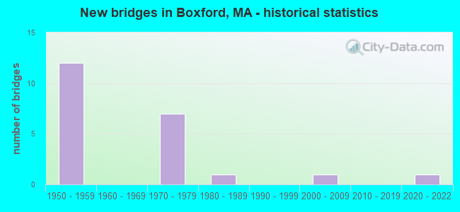
- New bridges - historical statistics
- 121950-1959
- 71970-1979
- 11980-1989
- 12000-2009
- 12020-2022


- Bridge Condition - Deck
- 10.0%Very good
- 30.0%Good
- 40.0%Satisfactory
- 20.0%Fair

- Bridge Condition - Superstructure
- 9.1%Very good
- 18.2%Good
- 36.4%Satisfactory
- 36.4%Fair

- Bridge Condition - Substructure
- 18.2%Very good
- 18.2%Good
- 36.4%Satisfactory
- 27.3%Fair

- Bridge Condition - Channel
- 83.3%Good
- 16.7%Satisfactory
Find on map >> Show street view
Structure Number: B190028REMUNNBI, Location: 1.1 MILE WEST OF I 95 (Lat: 42.655214, Lng: -70.999422), Route carried "on" structure: City street , Year Built: 2004, Status: Open, Structure Length: 1.52m (4.99ft), Average Daily Traffic: 1,200 (year 2017), Truck Traffic: 11%, Average Future Daily Traffic: 869 (year 2032), Design Load: HS 20, Features Intersected: WATER FISH BROOK, Facility Carried by Structure: HWY MILL ROAD
Minimum Vertical Clearance: 30+ m (98+ ft), Kilometerpoint: 0.660, Lanes on structure: 2, Owner: Town or Township Highway Agency, Approaching Roadway Width: 6.8m (22.3ft), Material/Design: Prestressed concrete, Design/Construction: Slab, Number Of Spans In Main Unit: 1, Length of Maximum Span: 14.3m (46.9ft), Curb-To-Curb Width: 6.4m (21.0ft), Out-to-Out Width: 7.6m (24.9ft)
Condition: Deck: Good, Superstructure: Good, Substructure: Very good, Channel: Good, Operating Rating: 81.7 metric tons, Method Used To Determine Operating Rating: Load Factor (LF), Inventory Rating: 48.9 metric tons, Method Used To Determine Inventory Rating: Load Factor (LF), Structural Evaluation: Better than present minimum criteria, Deck Geometry: High priority of replacement, Waterway Adequacy: Superior to present desirable criteria, Approach Roadway Alignment: Meets minimum limits, Length Of Structure Improvement: 1.60m (5.25ft), Designated Inspection Frequency: Every 24 months, Inspection Date: May 2021, Bridge Improvement Cost: $1,056,000, Roadway Improvement Cost: $106,000, Total Project Cost: $1,585,000 ( Estimate for 2022), Deck Structure Type: Concrete Precast Panels, Wearing Surface/Protective System: Wearing Surface: Bituminous, Membrane: Built-up, Deck Protection: Epoxy Coated Reinforcing
Find on map >> Show street view
Structure Number: B190032R3MUNNBI, Location: MILE WEST I 95 (Lat: 42.644667, Lng: -70.990056), Route carried "on" structure: City street , Year Built: 1988, Status: Open, Structure Length: 0.64m (2.10ft), Average Daily Traffic: 300 (year 2017), Truck Traffic: 5%, Average Future Daily Traffic: 7,900 (year 2032), Design Load: H 20, Features Intersected: WATER FISH BROOK, Facility Carried by Structure: HWY LOCKWOOD LN
Minimum Vertical Clearance: 30+ m (98+ ft), Kilometerpoint: 0.193, Lanes on structure: 2, Owner: Town or Township Highway Agency, Approaching Roadway Width: 6.1m (20.0ft), Material/Design: Aluminum, Iron, Design/Construction: Culvert, Number Of Spans In Main Unit: 2, Length of Maximum Span: 3.0m (9.8ft), Curb-To-Curb Width: 6.3m (20.7ft), Out-to-Out Width: 9.1m (29.9ft)
Condition: Channel: Satisfactory, Culverts: Satisfactory, Operating Rating: 56.5 metric tons, Method Used To Determine Operating Rating: Load Factor (LF), Inventory Rating: 33.8 metric tons, Method Used To Determine Inventory Rating: Load Factor (LF), Structural Evaluation: Equal to present minimum criteria, Deck Geometry: Meets minimum limits, Waterway Adequacy: Equal to present desirable criteria, Approach Roadway Alignment: Equal to present desirable criteria, Length Of Structure Improvement: 0.50m (1.64ft), Designated Inspection Frequency: Every 24 months, Underwater Inspection Frequency: Every 36 months, Inspection Date: January 2021, Underwater Inspection Date: March 2019, Bridge Improvement Cost: $299,000, Roadway Improvement Cost: $30,000, Total Project Cost: $449,000 ( Estimate for 2022)
Find on map >> Show street view
Structure Number: B190082VADOTNBI, Location: .9 MI N IPSWICH RIVER (Lat: 42.634569, Lng: -70.976997), Route carried "on" structure: Interstate 95, Year Built: 1976, Status: Open, Structure Length: 1.10m (3.61ft), Average Daily Traffic: 42,764 (year 2016), Truck Traffic: 12%, Average Future Daily Traffic: 89,704 (year 2032), Design Load: HS 20+Mod, Features Intersected: HWY FULLER LN
Minimum Vertical Clearance: 30+ m (98+ ft), Kilometerpoint: 115.644, Lanes on structure: 4, Lanes under structure: 2, Base Highway Network: Yes, Owner: State Highway Agency, Approaching Roadway Width: 20.1m (65.9ft), Skew: 11 degrees, Material/Design: Steel, Design/Construction: Stringer/Multi-beam, Number Of Spans In Main Unit: 1, Length of Maximum Span: 10.4m (34.1ft), Curb or Sidewalk Widths: Left: 0.6m (2.0ft), Right: 0.6m (2.0ft), Curb-To-Curb Width: 19.7m (64.6ft), Out-to-Out Width: 21.1m (69.2ft)
Condition: Deck: Satisfactory, Superstructure: Satisfactory, Substructure: Fair, Operating Rating: 55.4 metric tons, Method Used To Determine Operating Rating: Load Factor (LF), Inventory Rating: 33.2 metric tons, Method Used To Determine Inventory Rating: Load Factor (LF), Structural Evaluation: Somewhat better than minimum adequacy, Deck Geometry: Equal to present minimum criteria, Underclear: High priority of corrective action, Approach Roadway Alignment: Equal to present desirable criteria, Length Of Structure Improvement: 1.20m (3.94ft), Designated Inspection Frequency: Every 24 months, Inspection Date: January 2021, Bridge Improvement Cost: $995,000, Roadway Improvement Cost: $100,000, Total Project Cost: $1,493,000 ( Estimate for 2022), Deck Structure Type: Concrete Cast-file-Place, Wearing Surface/Protective System: Wearing Surface: Bituminous, Membrane: Built-up
Find on map >> Show street view
Structure Number: B190082VBDOTNBI, Location: .9 MI N IPSWICH RIVER (Lat: 42.634525, Lng: -70.977514), Route carried "on" structure: Interstate 95, Year Built: 1950, Year Reconstructed: 1976, Status: Open, Structure Length: 1.10m (3.61ft), Average Daily Traffic: 42,919 (year 2016), Truck Traffic: 12%, Average Future Daily Traffic: 89,704 (year 2032), Design Load: HS 20+Mod, Features Intersected: HWY FULLER LN
Minimum Vertical Clearance: 30+ m (98+ ft), Kilometerpoint: 115.644, Lanes on structure: 4, Lanes under structure: 2, Base Highway Network: Yes, Owner: State Highway Agency, Approaching Roadway Width: 20.1m (65.9ft), Skew: 1 degrees, Material/Design: Steel, Design/Construction: Stringer/Multi-beam, Number Of Spans In Main Unit: 1, Length of Maximum Span: 10.4m (34.1ft), Curb or Sidewalk Widths: Left: 0.6m (2.0ft), Right: 0.6m (2.0ft), Curb-To-Curb Width: 19.7m (64.6ft), Out-to-Out Width: 21.1m (69.2ft)
Condition: Deck: Good, Superstructure: Satisfactory, Substructure: Fair, Operating Rating: 58.5 metric tons, Method Used To Determine Operating Rating: Load Factor (LF), Inventory Rating: 35.1 metric tons, Method Used To Determine Inventory Rating: Load Factor (LF), Structural Evaluation: Somewhat better than minimum adequacy, Deck Geometry: Equal to present minimum criteria, Underclear: High priority of corrective action, Approach Roadway Alignment: Equal to present desirable criteria, Length Of Structure Improvement: 1.20m (3.94ft), Designated Inspection Frequency: Every 24 months, Inspection Date: January 2021, Bridge Improvement Cost: $995,000, Roadway Improvement Cost: $100,000, Total Project Cost: $1,493,000 ( Estimate for 2022), Deck Structure Type: Concrete Cast-file-Place, Wearing Surface/Protective System: Wearing Surface: Bituminous, Membrane: Built-up
Find on map >> Show street view
Structure Number: B190092VCDOTNBI, Location: 1.3 MI N IPSWICH RIVER (Lat: 42.640808, Lng: -70.976617), Route carried "on" structure: Interstate 95, Year Built: 1976, Status: Open, Structure Length: 1.37m (4.49ft), Average Daily Traffic: 43,300 (year 2019), Truck Traffic: 12%, Average Future Daily Traffic: 91,284 (year 2032), Design Load: HS 20, Features Intersected: WATER FISH BROOK
Minimum Vertical Clearance: 30+ m (98+ ft), Kilometerpoint: 116.335, Lanes on structure: 4, Base Highway Network: Yes, Owner: State Highway Agency, Approaching Roadway Width: 20.1m (65.9ft), Skew: 1 degrees, Material/Design: Steel, Design/Construction: Stringer/Multi-beam, Number Of Spans In Main Unit: 1, Length of Maximum Span: 11.9m (39.0ft), Curb-To-Curb Width: 19.7m (64.6ft), Out-to-Out Width: 21.1m (69.2ft)
Condition: Deck: Good, Superstructure: Fair, Substructure: Good, Channel: Good, Operating Rating: 55.6 metric tons, Method Used To Determine Operating Rating: Load Factor (LF), Inventory Rating: 33.3 metric tons, Method Used To Determine Inventory Rating: Load Factor (LF), Structural Evaluation: Somewhat better than minimum adequacy, Deck Geometry: Equal to present minimum criteria, Waterway Adequacy: Equal to present desirable criteria, Approach Roadway Alignment: Equal to present desirable criteria, Length Of Structure Improvement: 1.40m (4.59ft), Designated Inspection Frequency: Every 24 months, Underwater Inspection Frequency: Every 36 months, Inspection Date: July 2021, Underwater Inspection Date: April 2021, Bridge Improvement Cost: $1,161,000, Roadway Improvement Cost: $117,000, Total Project Cost: $1,742,000 ( Estimate for 2022), Deck Structure Type: Concrete Cast-file-Place, Wearing Surface/Protective System: Wearing Surface: Bituminous, Membrane: Built-up
Find on map >> Show street view
Structure Number: B190092VDDOTNBI, Location: 1.3 MI N IPSWICH RIVER (Lat: 42.640892, Lng: -70.977114), Route carried "on" structure: Interstate 95, Year Built: 1950, Year Reconstructed: 1976, Status: Open, Structure Length: 1.37m (4.49ft), Average Daily Traffic: 43,600 (year 2019), Truck Traffic: 12%, Average Future Daily Traffic: 91,284 (year 2032), Design Load: HS 20, Features Intersected: WATER FISH BROOK
Minimum Vertical Clearance: 30+ m (98+ ft), Kilometerpoint: 116.335, Lanes on structure: 4, Base Highway Network: Yes, Owner: State Highway Agency, Approaching Roadway Width: 20.1m (65.9ft), Skew: 1 degrees, Material/Design: Steel, Design/Construction: Stringer/Multi-beam, Number Of Spans In Main Unit: 1, Length of Maximum Span: 11.9m (39.0ft), Curb-To-Curb Width: 19.7m (64.6ft), Out-to-Out Width: 21.1m (69.2ft)
Condition: Deck: Satisfactory, Superstructure: Fair, Substructure: Satisfactory, Channel: Good, Operating Rating: 56.0 metric tons, Method Used To Determine Operating Rating: Load Factor (LF), Inventory Rating: 33.6 metric tons, Method Used To Determine Inventory Rating: Load Factor (LF), Structural Evaluation: Somewhat better than minimum adequacy, Deck Geometry: Equal to present minimum criteria, Waterway Adequacy: Equal to present desirable criteria, Approach Roadway Alignment: Equal to present desirable criteria, Length Of Structure Improvement: 1.40m (4.59ft), Designated Inspection Frequency: Every 24 months, Underwater Inspection Frequency: Every 36 months, Inspection Date: July 2021, Underwater Inspection Date: April 2021, Bridge Improvement Cost: $1,161,000, Roadway Improvement Cost: $117,000, Total Project Cost: $1,742,000 ( Estimate for 2022), Deck Structure Type: Concrete Cast-file-Place, Wearing Surface/Protective System: Wearing Surface: Bituminous, Membrane: Built-up
Find on map >> Show street view
Structure Number: B1901030BDOTNBI, Location: 1.4 MI N IPSWICH RIVER (Lat: 42.642231, Lng: -70.976914), Route carried "on" structure: State highway , Year Built: 1976, Status: Open, Structure Length: 7.89m (25.89ft), Average Daily Traffic: 79,154 (year 2015), Truck Traffic: 10%, Average Future Daily Traffic: 2,843 (year 2032), Design Load: H 20, Features Intersected: I 95, Facility Carried by Structure: HWY LOCKWOOD LN
Minimum Vertical Clearance: 30+ m (98+ ft), Kilometerpoint: 1.304, Lanes on structure: 2, Lanes under structure: 8, Owner: State Highway Agency, Approaching Roadway Width: 10.4m (34.1ft), Skew: 1 degrees, Material/Design: Steel continuous, Design/Construction: Stringer/Multi-beam, Number Of Spans In Main Unit: 2, Length of Maximum Span: 38.7m (127.0ft), Curb or Sidewalk Widths: Left: 1.5m (4.9ft), Right: 0.5m (1.6ft), Curb-To-Curb Width: 9.8m (32.2ft), Out-to-Out Width: 12.6m (41.3ft)
Condition: Deck: Satisfactory, Superstructure: Fair, Substructure: Satisfactory, Operating Rating: 54.2 metric tons, Method Used To Determine Operating Rating: Load Factor (LF), Inventory Rating: 32.5 metric tons, Method Used To Determine Inventory Rating: Load Factor (LF), Structural Evaluation: Somewhat better than minimum adequacy, Deck Geometry: Meets minimum limits, Underclear: High priority of corrective action, Approach Roadway Alignment: Equal to present desirable criteria, Length Of Structure Improvement: 7.90m (25.92ft), Designated Inspection Frequency: Every 24 months, Inspection Date: January 2021, Bridge Improvement Cost: $3,910,000, Roadway Improvement Cost: $392,000, Total Project Cost: $5,866,000 ( Estimate for 2022), Deck Structure Type: Concrete Cast-file-Place, Wearing Surface/Protective System: Wearing Surface: Bituminous, Membrane: Built-up
Find on map >> Show street view
Structure Number: B190112Y5DOTNBI, Location: 2.1 MI N IPSWICH RIVER (Lat: 42.651164, Lng: -70.977100), Route carried "on" structure: State highway , Year Built: 1974, Status: Open, Structure Length: 11.13m (36.52ft), Average Daily Traffic: 10,400 (year 2019), Truck Traffic: 8%, Average Future Daily Traffic: 5,685 (year 2032), Design Load: H 20, Features Intersected: I 95, Facility Carried by Structure: HWY TOPSFIELD RD
Minimum Vertical Clearance: 30+ m (98+ ft), Kilometerpoint: 2.012, Lanes on structure: 2, Lanes under structure: 8, Owner: State Highway Agency, Approaching Roadway Width: 13.4m (44.0ft), Skew: 4 degrees, Material/Design: Steel continuous, Design/Construction: Stringer/Multi-beam, Number Of Spans In Main Unit: 2, Length of Maximum Span: 55.0m (180.4ft), Curb or Sidewalk Widths: Left: 1.5m (4.9ft), Right: 0.5m (1.6ft), Curb-To-Curb Width: 13.4m (44.0ft), Out-to-Out Width: 16.2m (53.1ft)
Condition: Deck: Fair, Superstructure: Fair, Substructure: Fair, Operating Rating: 74.9 metric tons, Method Used To Determine Operating Rating: Load Factor (LF), Inventory Rating: 44.8 metric tons, Method Used To Determine Inventory Rating: Load Factor (LF), Structural Evaluation: Somewhat better than minimum adequacy, Deck Geometry: Equal to present minimum criteria, Underclear: High priority of corrective action, Approach Roadway Alignment: Equal to present desirable criteria, Length Of Structure Improvement: 11.20m (36.75ft), Designated Inspection Frequency: Every 24 months, Inspection Date: January 2021, Bridge Improvement Cost: $7,127,000, Roadway Improvement Cost: $713,000, Total Project Cost: $10,691,000 ( Estimate for 2022), Deck Structure Type: Concrete Cast-file-Place, Wearing Surface/Protective System: Wearing Surface: Bituminous, Membrane: Built-up
Find on map >> Show street view
Structure Number: B1901230CDOTNBI, Location: BEARHILL RD AT I-95 (Lat: 42.662264, Lng: -70.976767), Route carried "on" structure: State highway , Year Built: 1974, Status: Open, Structure Length: 9.05m (29.69ft), Average Daily Traffic: 1,600 (year 2017), Truck Traffic: 9%, Average Future Daily Traffic: 790 (year 2032), Design Load: H 20, Features Intersected: I 95, Facility Carried by Structure: HWY BARE HILL RD
Minimum Vertical Clearance: 30+ m (98+ ft), Kilometerpoint: 1.416, Lanes on structure: 2, Lanes under structure: 8, Owner: State Highway Agency, Approaching Roadway Width: 10.4m (34.1ft), Skew: 3 degrees, Material/Design: Steel continuous, Design/Construction: Stringer/Multi-beam, Number Of Spans In Main Unit: 2, Length of Maximum Span: 44.8m (147.0ft), Curb or Sidewalk Widths: Left: 0.5m (1.6ft), Right: 1.7m (5.6ft), Curb-To-Curb Width: 9.8m (32.2ft), Out-to-Out Width: 12.5m (41.0ft)
Condition: Deck: Satisfactory, Superstructure: Satisfactory, Substructure: Satisfactory, Operating Rating: 64.6 metric tons, Method Used To Determine Operating Rating: Load Factor (LF), Inventory Rating: 38.7 metric tons, Method Used To Determine Inventory Rating: Load Factor (LF), Structural Evaluation: Equal to present minimum criteria, Deck Geometry: Somewhat better than minimum adequacy, Underclear: High priority of corrective action, Approach Roadway Alignment: Equal to present desirable criteria, Length Of Structure Improvement: 9.10m (29.86ft), Designated Inspection Frequency: Every 24 months, Inspection Date: January 2021, Bridge Improvement Cost: $3,089,000, Roadway Improvement Cost: $309,000, Total Project Cost: $4,634,000 ( Estimate for 2022), Deck Structure Type: Concrete Cast-file-Place, Wearing Surface/Protective System: Wearing Surface: Bituminous, Membrane: Built-up
Find on map >> Show street view
Structure Number: B19013C60MUNNBI, Location: JUST WEST I 95 (Lat: 42.645169, Lng: -70.989056), Route carried "on" structure: City street , Year Built: 2020, Status: Open, Structure Length: 0.78m (2.56ft), Average Daily Traffic: 500 (year 2020), Truck Traffic: 5%, Design Load: HL 93, Features Intersected: WATER FISH BROOK, Facility Carried by Structure: HWY LOCKWOOD LN
Minimum Vertical Clearance: 0.00m, Kilometerpoint: 0.032, Lanes on structure: 2, Owner: Town or Township Highway Agency, Approaching Roadway Width: 6.6m (21.7ft), Skew: 4 degrees, Material/Design: Prestressed concrete, Design/Construction: Box Beam or Girders - Single/Spread, Number Of Spans In Main Unit: 1, Length of Maximum Span: 7.0m (23.0ft), Curb-To-Curb Width: 7.5m (24.6ft), Out-to-Out Width: 7.6m (24.9ft)
Condition: Deck: Very good, Superstructure: Very good, Substructure: Very good, Channel: Good, Operating Rating: 42.1 metric tons, Method Used To Determine Operating Rating: Assigned ratings based on Load and Resistance Factor Design (LRFD) reported by rating factor (RF) using HL93 loadings, Inventory Rating: 32.4 metric tons, Method Used To Determine Inventory Rating: Assigned ratings based on Load and Resistance Factor Design (LRFD) reported by rating factor (RF) using HL93 loadings, Structural Evaluation: Equal to present desirable criteria, Deck Geometry: Meets minimum limits, Waterway Adequacy: Superior to present desirable criteria, Approach Roadway Alignment: Equal to present desirable criteria, Designated Inspection Frequency: Every 24 months, Inspection Date: March 2021, Deck Structure Type: Concrete Cast-file-Place, Wearing Surface/Protective System: Wearing Surface: Monolithic Concrete
Find on map >> Show street view
Structure Number: B1901430DDOTNBI, Location: 4.2 MI N IPSWICH RIVER (Lat: 42.683125, Lng: -70.975083), Route carried "on" structure: State highway 97, Year Built: 1974, Status: Open, Structure Length: 7.83m (25.69ft), Average Daily Traffic: 16,100 (year 2017), Truck Traffic: 10%, Average Future Daily Traffic: 18,004 (year 2032), Design Load: H 20, Features Intersected: I 95
Minimum Vertical Clearance: 30+ m (98+ ft), Kilometerpoint: 15.219, Lanes on structure: 4, Lanes under structure: 8, Base Highway Network: Yes, Owner: State Highway Agency, Approaching Roadway Width: 14.0m (45.9ft), Skew: 1 degrees, Material/Design: Steel continuous, Design/Construction: Stringer/Multi-beam, Number Of Spans In Main Unit: 2, Length of Maximum Span: 38.7m (127.0ft), Curb or Sidewalk Widths: Left: 1.5m (4.9ft), Right: 0.5m (1.6ft), Curb-To-Curb Width: 14.6m (47.9ft), Out-to-Out Width: 17.4m (57.1ft)
Condition: Deck: Fair, Superstructure: Good, Substructure: Satisfactory, Operating Rating: 59.6 metric tons, Method Used To Determine Operating Rating: Load Factor (LF), Inventory Rating: 35.7 metric tons, Method Used To Determine Inventory Rating: Load Factor (LF), Structural Evaluation: Equal to present minimum criteria, Deck Geometry: High priority of replacement, Underclear: High priority of corrective action, Approach Roadway Alignment: Superior to present desirable criteria, Length Of Structure Improvement: 7.90m (25.92ft), Designated Inspection Frequency: Every 24 months, Inspection Date: January 2021, Bridge Improvement Cost: $9,906,000, Roadway Improvement Cost: $991,000, Total Project Cost: $14,860,000 ( Estimate for 2022), Deck Structure Type: Concrete Cast-file-Place, Wearing Surface/Protective System: Wearing Surface: Bituminous, Membrane: Built-up
Find on map >> Show street view
Structure Number: B190162R4MUNNBI, Location: .1 MILES WEST MAIN STREET (Lat: 42.662300, Lng: -71.018553), Route carried "on" structure: City street , Year Built: 1970, Status: Open, Structure Length: 0.76m (2.49ft), Average Daily Traffic: 620 (year 2019), Truck Traffic: 5%, Average Future Daily Traffic: 2,053 (year 2032), Design Load: H 20, Features Intersected: WATER FISH BROOK, Facility Carried by Structure: HWY TOWNE RD
Minimum Vertical Clearance: 30+ m (98+ ft), Kilometerpoint: 0.097, Lanes on structure: 2, Owner: Town or Township Highway Agency, Approaching Roadway Width: 6.4m (21.0ft), Material/Design: Aluminum, Iron, Design/Construction: Arch - Deck, Number Of Spans In Main Unit: 3, Length of Maximum Span: 2.1m (6.9ft), Curb-To-Curb Width: 8.7m (28.5ft), Out-to-Out Width: 10.1m (33.1ft)
Condition: Superstructure: Satisfactory, Substructure: Good, Channel: Good, Structural Evaluation: Equal to present minimum criteria, Deck Geometry: Somewhat better than minimum adequacy, Waterway Adequacy: Superior to present desirable criteria, Approach Roadway Alignment: Equal to present desirable criteria, Length Of Structure Improvement: 0.80m (2.62ft), Designated Inspection Frequency: Every 24 months, Inspection Date: March 2021, Bridge Improvement Cost: $264,000, Roadway Improvement Cost: $27,000, Total Project Cost: $397,000 ( Estimate for 2022)
Find on map >> Show street view
Structure Number: B190072Y4DOTNBI, Location: .3 MI N IPSWICH RIVER (Lat: 42.633333, Lng: -70.983333), Route carried "under" structure: Interstate 95, Year Built: 1950, Structure Length: 0. m, Average Daily Traffic: 23,000 (year 0000), Features Intersected: I 95 SB, Facility Carried by Structure: HWY ENDICOTT RD
Minimum Vertical Clearance: 4.75m (15.58ft), Kilometerpoint: 114.743, Lanes on structure: 4, Lanes under structure: 2, Material/Design: Steel continuous, Design/Construction: Stringer/Multi-beam, Length of Maximum Span: 51.8m (169.9ft)
Find on map >> Show street view
Structure Number: B190072Y4DOTNBI, Location: .3 MILES NO IPSWICH RIVER (Lat: 42.633333, Lng: -70.983333), Route carried "under" structure: Interstate 95, Year Built: 1950, Structure Length: 0. m, Average Daily Traffic: 23,000 (year 0000), Features Intersected: I 95 NB, Facility Carried by Structure: HWY ENDICOTT RD
Minimum Vertical Clearance: 4.75m (15.58ft), Kilometerpoint: 114.743, Lanes on structure: 4, Lanes under structure: 2, Material/Design: Steel continuous, Design/Construction: Stringer/Multi-beam, Length of Maximum Span: 51.8m (169.9ft)
Find on map >> Show street view
Structure Number: B1901030BDOTNBI, Location: 1.4 MI NO IPSWICH RIVER (Lat: 42.650000, Lng: -70.983333), Route carried "under" structure: Interstate 95, Year Built: 1950, Structure Length: 0. m, Average Daily Traffic: 23,000 (year 0000), Features Intersected: I 95 SB, Facility Carried by Structure: HWY LCKWOOD LN
Minimum Vertical Clearance: 4.52m (14.83ft), Kilometerpoint: 116.484, Lanes on structure: 4, Lanes under structure: 2, Material/Design: Steel continuous, Design/Construction: Stringer/Multi-beam, Length of Maximum Span: 38.7m (127.0ft)
Find on map >> Show street view
Structure Number: B1901030BDOTNBI, Location: 1.4 MI N IPSWICH RIVER (Lat: 42.650000, Lng: -70.983333), Route carried "under" structure: Interstate 95, Year Built: 1950, Structure Length: 0. m, Average Daily Traffic: 23,000 (year 0000), Features Intersected: I 95 NB, Facility Carried by Structure: HWY LCKWOOD LN
Minimum Vertical Clearance: 4.52m (14.83ft), Kilometerpoint: 116.484, Lanes on structure: 4, Lanes under structure: 2, Material/Design: Steel continuous, Design/Construction: Stringer/Multi-beam, Length of Maximum Span: 38.7m (127.0ft)
Find on map >> Show street view
Structure Number: B190112Y5DOTNBI, Location: 2.1 MI N IPSWICH RIVER (Lat: 42.650000, Lng: -70.983333), Route carried "under" structure: Interstate 95, Year Built: 1950, Structure Length: 0. m, Average Daily Traffic: 23,000 (year 0000), Features Intersected: I 95 NB, Facility Carried by Structure: HWY TOPFIELD RD
Minimum Vertical Clearance: 4.44m (14.57ft), Kilometerpoint: 117.448, Lanes on structure: 4, Lanes under structure: 2, Material/Design: Steel, Design/Construction: Stringer/Multi-beam, Length of Maximum Span: 55.2m (181.1ft)
Find on map >> Show street view
Structure Number: B190112Y5DOTNBI, Location: 2.1 MI NO IPSWICH RIVER (Lat: 42.650000, Lng: -70.983333), Route carried "under" structure: Interstate 95, Year Built: 1950, Structure Length: 0. m, Average Daily Traffic: 23,000 (year 0000), Features Intersected: I 95 SB, Facility Carried by Structure: HWY TOPFIELD RD
Minimum Vertical Clearance: 4.44m (14.57ft), Kilometerpoint: 117.448, Lanes on structure: 4, Lanes under structure: 2, Material/Design: Steel, Design/Construction: Stringer/Multi-beam, Length of Maximum Span: 55.2m (181.1ft)
Find on map >> Show street view
Structure Number: B1901230CDOTNBI, Location: BEARHILL RD AT I 95 (Lat: 42.666667, Lng: -70.983333), Route carried "under" structure: Interstate 95, Year Built: 1950, Structure Length: 0. m, Average Daily Traffic: 23,000 (year 0000), Features Intersected: I 95 SB, Facility Carried by Structure: HWY BARE HILL RD
Minimum Vertical Clearance: 4.44m (14.57ft), Kilometerpoint: 118.702, Lanes on structure: 4, Lanes under structure: 2, Material/Design: Steel continuous, Design/Construction: Stringer/Multi-beam, Length of Maximum Span: 44.8m (147.0ft)
Find on map >> Show street view
Structure Number: B1901230CDOTNBI, Location: BEARHILL RD AT I-95 (Lat: 42.666667, Lng: -70.983333), Route carried "under" structure: Interstate 95, Year Built: 1950, Structure Length: 0. m, Average Daily Traffic: 23,000 (year 0000), Features Intersected: I 95 NB, Facility Carried by Structure: HWY BARE HILL RD
Minimum Vertical Clearance: 4.44m (14.57ft), Kilometerpoint: 118.702, Lanes on structure: 4, Lanes under structure: 2, Material/Design: Steel continuous, Design/Construction: Stringer/Multi-beam, Length of Maximum Span: 44.8m (147.0ft)
Find on map >> Show street view
Structure Number: B1901430DDOTNBI, Location: 4.2 MI N IPSWICH RIVER (Lat: 42.683333, Lng: -70.983333), Route carried "under" structure: Interstate 95, Year Built: 1951, Structure Length: 0. m, Average Daily Traffic: 23,000 (year 0000), Features Intersected: I 95 SB, Facility Carried by Structure: ST 97 KILLAM HILL
Minimum Vertical Clearance: 4.57m (14.99ft), Kilometerpoint: 121.031, Lanes on structure: 4, Lanes under structure: 4, Material/Design: Steel continuous, Design/Construction: Stringer/Multi-beam, Length of Maximum Span: 38.7m (127.0ft)
Find on map >> Show street view
Structure Number: B1901430DDOTNBI, Location: 4.2 MI N IPSWICH RIVER (Lat: 42.683333, Lng: -70.983333), Route carried "under" structure: Interstate 95, Year Built: 1951, Structure Length: 0. m, Average Daily Traffic: 23,000 (year 0000), Features Intersected: I 95 NB, Facility Carried by Structure: ST 97 KILLAM HILL
Minimum Vertical Clearance: 4.57m (14.99ft), Kilometerpoint: 121.031, Lanes on structure: 4, Lanes under structure: 4, Material/Design: Steel continuous, Design/Construction: Stringer/Multi-beam, Length of Maximum Span: 38.7m (127.0ft)