Bridge Statistics for Bratenahl, Ohio (OH)
Condition, Traffic, Stress, Structural Evaluation, Project Costs
- National Bridge Inventory (NBI) Statistics
- 10Number of bridges
- 59ft / 17.9mTotal length
- 673,523Total average daily traffic
- 28,838Total average daily truck traffic
- National Bridge Inventory (NBI) Registered Bridges for Bratenahl
- No street view available for this location
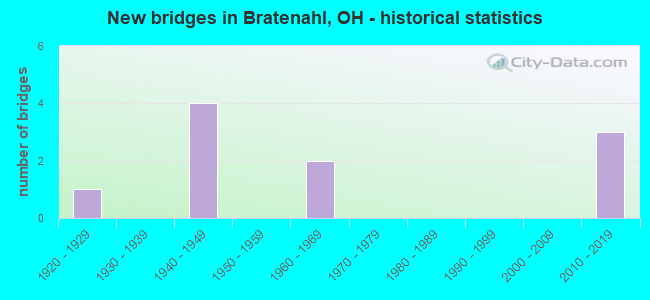
- New bridges - historical statistics
- 11920-1929
- 41940-1949
- 21960-1969
- 32010-2019


- Bridge Condition - Deck
- 25.0%Excellent
- 25.0%Very good
- 25.0%Satisfactory
- 25.0%Fair

- Bridge Condition - Superstructure
- 25.0%Excellent
- 25.0%Very good
- 25.0%Good
- 25.0%Satisfactory

- Bridge Condition - Substructure
- 25.0%Excellent
- 25.0%Very good
- 25.0%Good
- 25.0%Satisfactory

- Bridge Condition - Channel
- 25.0%Very good
- 50.0%Good
- 25.0%Satisfactory

- Bridge Condition - Culverts
- 66.7%Good
- 33.3%Satisfactory
Find on map >> Show street view
Structure Number: 1808494, Location: 1.31 MI E OF SR283DA (Lat: 41.545489, Lng: -81.615581), Route carried "on" structure: Interstate 90, Year Built: 1947, Year Reconstructed: 1961, Status: Open, Structure Length: 2.44m (8.01ft), Average Daily Traffic: 128,947 (year 2015), Truck Traffic: 4%, Average Future Daily Traffic: 178,978 (year 2035), Design Load: H 20, Features Intersected: CR 400 (EAST 105 ST)
Minimum Vertical Clearance: 30+ m (98+ ft), Kilometerpoint: 35.406, Lanes on structure: 8, Lanes under structure: 4, Base Highway Network: Yes, Owner: State Highway Agency, Approaching Roadway Width: 29.3m (96.1ft), Skew: 13 degrees, Material/Design: Steel, Design/Construction: Stringer/Multi-beam, Number Of Spans In Main Unit: 1, Length of Maximum Span: 22.3m (73.2ft), Curb-To-Curb Width: 35.1m (115.2ft), Out-to-Out Width: 35.7m (117.1ft)
Condition: Deck: Fair, Superstructure: Good, Substructure: Good, Operating Rating: 42.1 metric tons, Method Used To Determine Operating Rating: Allowable Stress (AS) rating reported by rating factor (RF) method using MS18 loading, Inventory Rating: 32.4 metric tons, Method Used To Determine Inventory Rating: Allowable Stress (AS) rating reported by rating factor (RF) method using MS18 loading, Structural Evaluation: Better than present minimum criteria, Deck Geometry: Equal to present minimum criteria, Underclear: High priority of corrective action, Approach Roadway Alignment: Equal to present desirable criteria, Designated Inspection Frequency: Every 12 months, Inspection Date: May 2021, Deck Structure Type: Concrete Cast-file-Place, Wearing Surface/Protective System: Wearing Surface: Integral Concrete, Membrane: Built-up
Find on map >> Show street view
Structure Number: 1808524, Location: 1.4, MI W SR 283 (Lat: 41.549039, Lng: -81.607669), Route carried "on" structure: Interstate 90, Year Built: 1925, Status: Open, Structure Length: 1.01m (3.31ft), Average Daily Traffic: 128,947 (year 2015), Truck Traffic: 4%, Average Future Daily Traffic: 178,978 (year 2035), Design Load: H 20, Features Intersected: DUGWAY BROOK
Minimum Vertical Clearance: 30+ m (98+ ft), Kilometerpoint: 36.130, Lanes on structure: 4, Base Highway Network: Yes, Owner: State Highway Agency, Approaching Roadway Width: 41.5m (136.2ft), Skew: 30 degrees, Material/Design: Concrete, Design/Construction: Culvert, Number Of Spans In Main Unit: 2, Length of Maximum Span: 4.6m (15.1ft)
Condition: Channel: Good, Culverts: Satisfactory, Operating Rating: 97.2 metric tons, Method Used To Determine Operating Rating: Load Factor (LF) rating reported by rating factor (RF) method using MS18 loading, Inventory Rating: 68.0 metric tons, Method Used To Determine Inventory Rating: Load Factor (LF) rating reported by rating factor (RF) method using MS18 loading, Structural Evaluation: Equal to present minimum criteria, Waterway Adequacy: Equal to present desirable criteria, Approach Roadway Alignment: Equal to present desirable criteria, Designated Inspection Frequency: Every 12 months, Inspection Date: September 2021
Find on map >> Show street view
Structure Number: 1808613, Location: 0.4O MI E EDDY ROAD (Lat: 41.556139, Lng: -81.595261), Route carried "on" structure: Interstate 90, Year Built: 1947, Status: Open, Structure Length: 1.28m (4.20ft), Average Daily Traffic: 127,369 (year 2015), Truck Traffic: 4%, Average Future Daily Traffic: 176,788 (year 2035), Design Load: H 20, Features Intersected: NINE MILE RUN @ MM 179.2
Minimum Vertical Clearance: 30+ m (98+ ft), Kilometerpoint: 37.643, Lanes on structure: 8, Base Highway Network: Yes, Owner: State Highway Agency, Approaching Roadway Width: 40.8m (133.9ft), Skew: 31 degrees, Material/Design: Concrete, Design/Construction: Culvert, Number Of Spans In Main Unit: 3, Length of Maximum Span: 4.3m (14.1ft)
Condition: Channel: Satisfactory, Culverts: Good, Operating Rating: 97.2 metric tons, Method Used To Determine Operating Rating: Load Factor (LF) rating reported by rating factor (RF) method using MS18 loading, Inventory Rating: 68.0 metric tons, Method Used To Determine Inventory Rating: Load Factor (LF) rating reported by rating factor (RF) method using MS18 loading, Structural Evaluation: Better than present minimum criteria, Waterway Adequacy: Equal to present desirable criteria, Approach Roadway Alignment: Equal to present desirable criteria, Designated Inspection Frequency: Every 24 months, Inspection Date: September 2021
Find on map >> Show street view
Structure Number: 1808648, Location: 0.18 MI E EDDY RD (Lat: 41.563800, Lng: -81.588839), Route carried "on" structure: State highway 283, Year Built: 1960, Status: Open, Structure Length: 6.13m (20.11ft), Average Daily Traffic: 2,425 (year 2015), Truck Traffic: 4%, Average Future Daily Traffic: 3,366 (year 2035), Design Load: HS 20+Mod, Features Intersected: IR-90 (SR-283 4870)
Minimum Vertical Clearance: 30+ m (98+ ft), Kilometerpoint: 7.838, Lanes on structure: 2, Lanes under structure: 8, Owner: State Highway Agency, Approaching Roadway Width: 10.4m (34.1ft), Skew: 4 degrees, Material/Design: Steel continuous, Design/Construction: Stringer/Multi-beam, Number Of Spans In Main Unit: 2, Length of Maximum Span: 29.6m (97.1ft), Curb-To-Curb Width: 10.4m (34.1ft), Out-to-Out Width: 11.1m (36.4ft)
Condition: Deck: Satisfactory, Superstructure: Satisfactory, Substructure: Satisfactory, Operating Rating: 42.1 metric tons, Method Used To Determine Operating Rating: Load Factor (LF) rating reported by rating factor (RF) method using MS18 loading, Inventory Rating: 32.4 metric tons, Method Used To Determine Inventory Rating: Load Factor (LF) rating reported by rating factor (RF) method using MS18 loading, Structural Evaluation: Equal to present minimum criteria, Deck Geometry: Somewhat better than minimum adequacy, Underclear: High priority of corrective action, Approach Roadway Alignment: Equal to present desirable criteria, Designated Inspection Frequency: Every 12 months, Inspection Date: July 2021, Deck Structure Type: Concrete Cast-file-Place, Wearing Surface/Protective System: Wearing Surface: Integral Concrete
Find on map >> Show street view
Structure Number: 1808907, Location: 1.18 MI W of SR 283 (Lat: 41.551000, Lng: -81.603081), Route carried "on" structure: County highway 318, Year Built: 2015, Status: Open, Structure Length: 4.37m (14.34ft), Average Daily Traffic: 9,170 (year 2015), Truck Traffic: 7%, Average Future Daily Traffic: 12,728 (year 2035), Design Load: HL 93, Features Intersected: IR-90 (EDDY)
Minimum Vertical Clearance: 30+ m (98+ ft), Kilometerpoint: 3.367, Lanes on structure: 4, Lanes under structure: 8, Owner: State Highway Agency, Approaching Roadway Width: 17.1m (56.1ft), Skew: 20 degrees, Material/Design: Prestressed concrete, Design/Construction: Stringer/Multi-beam, Number Of Spans In Main Unit: 1, Length of Maximum Span: 42.8m (140.4ft), Curb or Sidewalk Widths: Left: 1.9m (6.2ft), Right: 1.9m (6.2ft), Curb-To-Curb Width: 17.1m (56.1ft), Out-to-Out Width: 21.5m (70.5ft)
Condition: Deck: Very good, Superstructure: Very good, Substructure: Very good, Operating Rating: 42.1 metric tons, Method Used To Determine Operating Rating: Load and Resistance Factor Rating (LRFR) rating reported by rating factor(RF) method using HL-93 loadings, Inventory Rating: 32.4 metric tons, Method Used To Determine Inventory Rating: Load and Resistance Factor Rating (LRFR) rating reported by rating factor(RF) method using HL-93 loadings, Structural Evaluation: Equal to present desirable criteria, Deck Geometry: Somewhat better than minimum adequacy, Underclear: High priority of corrective action, Approach Roadway Alignment: Equal to present desirable criteria, Designated Inspection Frequency: Every 24 months, Inspection Date: July 2021, Deck Structure Type: Concrete Cast-file-Place, Wearing Surface/Protective System: Wearing Surface: Monolithic Concrete, Membrane: Epoxy, Deck Protection: Epoxy Coated Reinforcing
Find on map >> Show street view
Structure Number: 1832565, Location: 0.3 MI. W. OF BRATNAHL PL (Lat: 41.548950, Lng: -81.608761), Route carried "on" structure: County highway 282, Year Built: 1946, Status: Open, Structure Length: 1.10m (3.61ft), Average Daily Traffic: 6,702 (year 2015), Truck Traffic: 5%, Average Future Daily Traffic: 9,302 (year 2035), Design Load: HS 20, Features Intersected: DUGWAY BROOK
Minimum Vertical Clearance: 30+ m (98+ ft), Kilometerpoint: 0.579, Lanes on structure: 2, Owner: County Highway Agency, Approaching Roadway Width: 9.1m (29.9ft), Skew: 2 degrees, Material/Design: Concrete, Design/Construction: Culvert, Number Of Spans In Main Unit: 2, Length of Maximum Span: 4.6m (15.1ft)
Condition: Channel: Good, Culverts: Good, Operating Rating: 42.1 metric tons, Method Used To Determine Operating Rating: Load Factor (LF) rating reported by rating factor (RF) method using MS18 loading, Inventory Rating: 32.4 metric tons, Method Used To Determine Inventory Rating: Load Factor (LF) rating reported by rating factor (RF) method using MS18 loading, Structural Evaluation: Better than present minimum criteria, Waterway Adequacy: Superior to present desirable criteria, Approach Roadway Alignment: Equal to present desirable criteria, Designated Inspection Frequency: Every 24 months, Inspection Date: November 2021
Find on map >> Show street view
Structure Number: 1834274, Location: 500 FT EAST OF COIT RD (Lat: 41.557811, Lng: -81.600269), Route carried "on" structure: County highway C0282, Year Built: 2016, Status: Open, Structure Length: 1.55m (5.09ft), Average Daily Traffic: 3,600 (year 2016), Truck Traffic: 2%, Average Future Daily Traffic: 3,600 (year 2036), Design Load: HL 93, Features Intersected: NINE MILE CREEK, Facility Carried by Structure: LAKESHOR BLVD C282
Minimum Vertical Clearance: 30+ m (98+ ft), Kilometerpoint: 1.802, Lanes on structure: 2, Owner: County Highway Agency, Approaching Roadway Width: 8.8m (28.9ft), Material/Design: Concrete, Design/Construction: Arch - Deck, Number Of Spans In Main Unit: 1, Length of Maximum Span: 13.0m (42.7ft), Curb or Sidewalk Widths: Left: 1.5m (4.9ft), Right: 0.0m, Curb-To-Curb Width: 8.8m (28.9ft), Out-to-Out Width: 14.6m (47.9ft)
Condition: Deck: Excellent, Superstructure: Excellent, Substructure: Excellent, Channel: Very good, Operating Rating: 39.2 metric tons, Method Used To Determine Operating Rating: Load and Resistance Factor Rating (LRFR) rating reported by rating factor(RF) method using HL-93 loadings, Inventory Rating: 31.4 metric tons, Method Used To Determine Inventory Rating: Load and Resistance Factor Rating (LRFR) rating reported by rating factor(RF) method using HL-93 loadings, Structural Evaluation: Better than present minimum criteria, Deck Geometry: Meets minimum limits, Waterway Adequacy: Equal to present desirable criteria, Approach Roadway Alignment: Equal to present desirable criteria, Designated Inspection Frequency: Every 24 months, Inspection Date: April 2021, Deck Structure Type: Concrete Cast-file-Place, Wearing Surface/Protective System: Wearing Surface: Bituminous
Find on map >> Show street view
Structure Number: 1808494, Location: 1.31 MI E OF SR283DA (Lat: 41.545489, Lng: -81.615581), Route carried "under" structure: County highway 400, Year Built: 1947, Structure Length: 0. m, Average Daily Traffic: 10,957 (year 2015), Truck Traffic: 7%, Features Intersected: I-90, Facility Carried by Structure: IR90 OVER E.105TH
Minimum Vertical Clearance: 4.48m (14.70ft), Kilometerpoint: 5.778, Lanes on structure: 8, Lanes under structure: 4, Material/Design: Steel, Design/Construction: Stringer/Multi-beam, Length of Maximum Span: 22.3m (73.2ft)
Find on map >> Show street view
Structure Number: 1808648, Location: 0.18 MI E EDDY RD (Lat: 41.563800, Lng: -81.588839), Route carried "under" structure: Interstate 90, Year Built: 1960, Structure Length: 0. m, Average Daily Traffic: 124,947 (year 2015), Truck Traffic: 4%, Features Intersected: SR-283 EB (CUY-283-0487), Facility Carried by Structure: SR 283 EB
Minimum Vertical Clearance: 5.79m (19.00ft), Kilometerpoint: 38.512, Lanes on structure: 2, Lanes under structure: 8, Material/Design: Steel continuous, Design/Construction: Stringer/Multi-beam, Length of Maximum Span: 29.6m (97.1ft)
Find on map >> Show street view
Structure Number: 1808907, Location: 1.18 MI W of SR 283 (Lat: 41.551000, Lng: -81.603081), Route carried "under" structure: Interstate 90, Year Built: 2015, Structure Length: 0. m, Average Daily Traffic: 130,459 (year 2016), Truck Traffic: 5%, Features Intersected: CR-318 (EDDY RD), Facility Carried by Structure: EDDY RD. (CR-318)
Minimum Vertical Clearance: 5.56m (18.24ft), Kilometerpoint: 36.558, Lanes on structure: 4, Lanes under structure: 8, Material/Design: Prestressed concrete, Design/Construction: Stringer/Multi-beam, Length of Maximum Span: 42.8m (140.4ft)