Bridge Statistics for Brentwood, New York (NY)
Condition, Traffic, Stress, Structural Evaluation, Project Costs
- National Bridge Inventory (NBI) Statistics
- 24Number of bridges
- 194ft / 58.6mTotal length
- $87,081,000Total costs
- 1,368,293Total average daily traffic
- 25,032Total average daily truck traffic
- National Bridge Inventory (NBI) Registered Bridges for Brentwood
- No street view available for this location
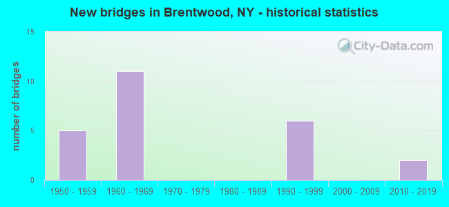
- New bridges - historical statistics
- 51950-1959
- 111960-1969
- 61990-1999
- 22010-2019
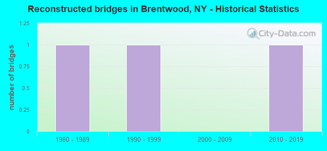
- Reconstructed bridges - Historical Statistics
- 11980-1989
- 11990-1999
- 02000-2009
- 12010-2019
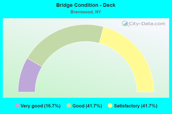
- Bridge Condition - Deck
- 16.7%Very good
- 41.7%Good
- 41.7%Satisfactory
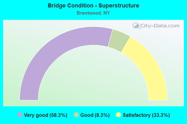
- Bridge Condition - Superstructure
- 58.3%Very good
- 8.3%Good
- 33.3%Satisfactory
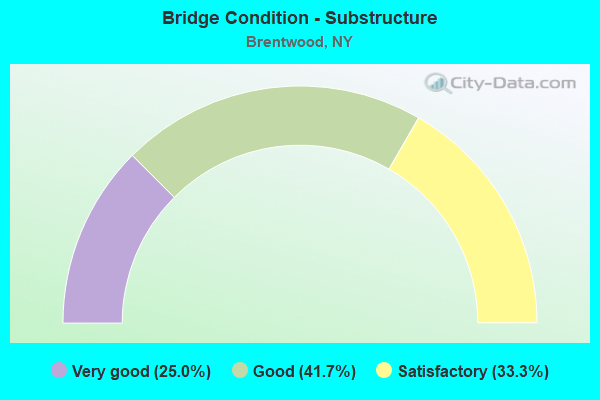
- Bridge Condition - Substructure
- 25.0%Very good
- 41.7%Good
- 33.3%Satisfactory
Find on map >> Show street view
Structure Number: 1049381, Location: 3.2 MI E JCT RTS 231+495 (Lat: 40.804722, Lng: -73.281053), Route carried "on" structure: State highway 908K, Year Built: 1964, Year Reconstructed: 1995, Status: Open, Structure Length: 12.01m (39.40ft), Average Daily Traffic: 41,779 (year 2019), Truck Traffic: 1%, Average Future Daily Traffic: 49,695 (year 2040), Design Load: H 20, Features Intersected: Long Island Expressway E
Minimum Vertical Clearance: 30+ m (98+ ft), Kilometerpoint: 6.854, Lanes on structure: 3, Lanes under structure: 20, Base Highway Network: Yes, Owner: State Highway Agency, Approaching Roadway Width: 12.5m (41.0ft), Skew: 2 degrees, Material/Design: Steel, Design/Construction: Stringer/Multi-beam, Number Of Spans In Main Unit: 4, Length of Maximum Span: 31.0m (101.7ft), Curb-To-Curb Width: 12.3m (40.4ft), Out-to-Out Width: 13.3m (43.6ft)
Condition: Deck: Satisfactory, Superstructure: Satisfactory, Substructure: Satisfactory, Operating Rating: 53.8 metric tons, Method Used To Determine Operating Rating: Load and Resistance Factor Rating (LRFR) rating reported by rating factor(RF) method using HL-93 loadings, Inventory Rating: 41.1 metric tons, Method Used To Determine Inventory Rating: Load and Resistance Factor Rating (LRFR) rating reported by rating factor(RF) method using HL-93 loadings, Structural Evaluation: Equal to present minimum criteria, Deck Geometry: Meets minimum limits, Underclear: Meets minimum limits, Approach Roadway Alignment: Equal to present desirable criteria, Length Of Structure Improvement: 12.00m (39.37ft), Designated Inspection Frequency: Every 24 months, Inspection Date: December 2021, Bridge Improvement Cost: $5,967,000, Roadway Improvement Cost: $3,494,000, Total Project Cost: $9,461,000 ( Estimate for 2021), Deck Structure Type: Concrete Cast-file-Place, Wearing Surface/Protective System: Wearing Surface: Integral Concrete, Deck Protection: Epoxy Coated Reinforcing
Find on map >> Show street view
Structure Number: 1049382, Location: 3.2 MI E JCT RTS 231+495 (Lat: 40.804717, Lng: -73.280731), Route carried "on" structure: State highway 908K, Year Built: 1964, Year Reconstructed: 1992, Status: Open, Structure Length: 11.89m (39.01ft), Average Daily Traffic: 41,779 (year 2019), Truck Traffic: 1%, Average Future Daily Traffic: 49,695 (year 2040), Design Load: H 20, Features Intersected: Long Island Expwy Servic
Minimum Vertical Clearance: 30+ m (98+ ft), Kilometerpoint: 6.854, Lanes on structure: 3, Lanes under structure: 19, Base Highway Network: Yes, Owner: State Highway Agency, Approaching Roadway Width: 12.5m (41.0ft), Skew: 2 degrees, Material/Design: Steel, Design/Construction: Stringer/Multi-beam, Number Of Spans In Main Unit: 4, Length of Maximum Span: 29.8m (97.8ft), Curb-To-Curb Width: 12.3m (40.4ft), Out-to-Out Width: 13.3m (43.6ft)
Condition: Deck: Satisfactory, Superstructure: Satisfactory, Substructure: Satisfactory, Operating Rating: 72.6 metric tons, Method Used To Determine Operating Rating: Load Factor (LF), Inventory Rating: 43.5 metric tons, Method Used To Determine Inventory Rating: Load Factor (LF), Structural Evaluation: Equal to present minimum criteria, Deck Geometry: Meets minimum limits, Underclear: High priority of corrective action, Approach Roadway Alignment: Equal to present desirable criteria, Length Of Structure Improvement: 11.88m (38.98ft), Designated Inspection Frequency: Every 24 months, Critical Feature Inspection Frequency: Every 24 months, Inspection Date: December 2021, Critical Feature Inspection Date: December 2021, Bridge Improvement Cost: $5,878,000, Roadway Improvement Cost: $3,442,000, Total Project Cost: $9,320,000 ( Estimate for 2021), Deck Structure Type: Concrete Cast-file-Place, Wearing Surface/Protective System: Wearing Surface: Integral Concrete, Deck Protection: Epoxy Coated Reinforcing
Find on map >> Show street view
Structure Number: 1049391, Location: 3.8 MI E JCT RTS 231&495 (Lat: 40.805003, Lng: -73.269208), Route carried "on" structure: ServiceState highway 906B, Year Built: 1993, Status: Open, Structure Length: 2.53m (8.30ft), Average Daily Traffic: 12,177 (year 2020), Truck Traffic: 7%, Average Future Daily Traffic: 14,050 (year 2040), Design Load: HS 20, Features Intersected: WICKS ROAD
Minimum Vertical Clearance: 30+ m (98+ ft), Kilometerpoint: 28.270, Lanes on structure: 3, Lanes under structure: 4, Base Highway Network: Yes, Owner: State Highway Agency, Approaching Roadway Width: 15.5m (50.9ft), Skew: 1 degrees, Material/Design: Steel, Design/Construction: Stringer/Multi-beam, Number Of Spans In Main Unit: 1, Length of Maximum Span: 23.7m (77.8ft), Curb-To-Curb Width: 15.7m (51.5ft), Out-to-Out Width: 16.6m (54.5ft)
Condition: Deck: Very good, Superstructure: Very good, Substructure: Very good, Operating Rating: 61.7 metric tons, Method Used To Determine Operating Rating: Load Factor (LF), Inventory Rating: 32.7 metric tons, Method Used To Determine Inventory Rating: Load Factor (LF), Structural Evaluation: Equal to present desirable criteria, Deck Geometry: Better than present minimum criteria, Underclear: Meets minimum limits, Approach Roadway Alignment: Equal to present desirable criteria, Length Of Structure Improvement: 2.52m (8.27ft), Designated Inspection Frequency: Every 24 months, Inspection Date: June 2020, Bridge Improvement Cost: $2,900,000, Roadway Improvement Cost: $1,698,000, Total Project Cost: $4,598,000 ( Estimate for 2021), Deck Structure Type: Concrete Cast-file-Place, Wearing Surface/Protective System: Wearing Surface: Integral Concrete, Deck Protection: Epoxy Coated Reinforcing
Find on map >> Show street view
Structure Number: 1049392, Location: 3.8 MI E JCT RTS 231+495 (Lat: 40.804844, Lng: -73.269175), Route carried "on" structure: Interstate 495, Year Built: 1964, Status: Open, Structure Length: 2.19m (7.19ft), Average Daily Traffic: 50,893 (year 2002), Truck Traffic: 13%, Design Load: HS 20+Mod, Features Intersected: WICKS ROAD
Minimum Vertical Clearance: 30+ m (98+ ft), Kilometerpoint: 15.334, Lanes on structure: 4, Lanes under structure: 4, Base Highway Network: Yes, Owner: State Highway Agency, Approaching Roadway Width: 21.0m (68.9ft), Skew: 1 degrees, Material/Design: Steel, Design/Construction: Stringer/Multi-beam, Number Of Spans In Main Unit: 1, Length of Maximum Span: 20.7m (67.9ft), Curb-To-Curb Width: 21.0m (68.9ft), Out-to-Out Width: 22.1m (72.5ft)
Condition: Deck: Good, Superstructure: Very good, Substructure: Good, Operating Rating: 62.6 metric tons, Method Used To Determine Operating Rating: Load Factor (LF), Inventory Rating: 37.2 metric tons, Method Used To Determine Inventory Rating: Load Factor (LF), Structural Evaluation: Better than present minimum criteria, Deck Geometry: Better than present minimum criteria, Underclear: Meets minimum limits, Approach Roadway Alignment: Equal to present desirable criteria, Length Of Structure Improvement: 2.19m (7.19ft), Designated Inspection Frequency: Every 24 months, Inspection Date: June 2020, Bridge Improvement Cost: $3,502,000, Roadway Improvement Cost: $2,051,000, Total Project Cost: $5,552,000 ( Estimate for 2021), Deck Structure Type: Concrete Cast-file-Place, Wearing Surface/Protective System: Wearing Surface: Integral Concrete
Find on map >> Show street view
Structure Number: 1049393, Location: 3.8 MI E JCT RTS 231+495 (Lat: 40.804581, Lng: -73.269117), Route carried "on" structure: Interstate 495, Year Built: 1964, Status: Open, Structure Length: 2.19m (7.19ft), Average Daily Traffic: 110,701 (year 2018), Truck Traffic: 9%, Average Future Daily Traffic: 116,236 (year 2040), Design Load: H 20, Features Intersected: WICKS ROAD
Minimum Vertical Clearance: 30+ m (98+ ft), Kilometerpoint: 15.334, Lanes on structure: 4, Lanes under structure: 4, Base Highway Network: Yes, Owner: State Highway Agency, Approaching Roadway Width: 21.0m (68.9ft), Skew: 1 degrees, Material/Design: Steel, Design/Construction: Stringer/Multi-beam, Number Of Spans In Main Unit: 1, Length of Maximum Span: 20.7m (67.9ft), Curb-To-Curb Width: 21.0m (68.9ft), Out-to-Out Width: 22.1m (72.5ft)
Condition: Deck: Good, Superstructure: Very good, Substructure: Good, Operating Rating: 62.6 metric tons, Method Used To Determine Operating Rating: Load Factor (LF), Inventory Rating: 37.2 metric tons, Method Used To Determine Inventory Rating: Load Factor (LF), Structural Evaluation: Better than present minimum criteria, Deck Geometry: Better than present minimum criteria, Underclear: Meets minimum limits, Approach Roadway Alignment: Equal to present desirable criteria, Length Of Structure Improvement: 2.19m (7.19ft), Designated Inspection Frequency: Every 24 months, Inspection Date: June 2020, Bridge Improvement Cost: $3,502,000, Roadway Improvement Cost: $2,051,000, Total Project Cost: $5,552,000 ( Estimate for 2021), Deck Structure Type: Concrete Cast-file-Place, Wearing Surface/Protective System: Wearing Surface: Integral Concrete
Find on map >> Show street view
Structure Number: 1049394, Location: 3.8 MI E JCT RTS 231&495I (Lat: 40.804433, Lng: -73.269086), Route carried "on" structure: ServiceState highway 906A, Year Built: 1991, Status: Open, Structure Length: 2.59m (8.50ft), Average Daily Traffic: 15,362 (year 2020), Truck Traffic: 9%, Average Future Daily Traffic: 17,724 (year 2040), Design Load: HS 20, Features Intersected: WICKS ROAD
Minimum Vertical Clearance: 30+ m (98+ ft), Kilometerpoint: 15.446, Lanes on structure: 2, Lanes under structure: 4, Base Highway Network: Yes, Owner: State Highway Agency, Approaching Roadway Width: 11.9m (39.0ft), Skew: 1 degrees, Material/Design: Steel, Design/Construction: Stringer/Multi-beam, Number Of Spans In Main Unit: 1, Length of Maximum Span: 24.3m (79.7ft), Curb-To-Curb Width: 12.0m (39.4ft), Out-to-Out Width: 13.0m (42.7ft)
Condition: Deck: Very good, Superstructure: Very good, Substructure: Good, Operating Rating: 60.6 metric tons, Method Used To Determine Operating Rating: Load and Resistance Factor Rating (LRFR) rating reported by rating factor(RF) method using HL-93 loadings, Inventory Rating: 46.7 metric tons, Method Used To Determine Inventory Rating: Load and Resistance Factor Rating (LRFR) rating reported by rating factor(RF) method using HL-93 loadings, Structural Evaluation: Better than present minimum criteria, Deck Geometry: Better than present minimum criteria, Underclear: Meets minimum limits, Approach Roadway Alignment: Equal to present desirable criteria, Length Of Structure Improvement: 2.59m (8.50ft), Designated Inspection Frequency: Every 24 months, Inspection Date: June 2020, Bridge Improvement Cost: $2,207,000, Roadway Improvement Cost: $1,292,000, Total Project Cost: $3,499,000 ( Estimate for 2021), Deck Structure Type: Concrete Cast-file-Place, Wearing Surface/Protective System: Wearing Surface: Integral Concrete, Deck Protection: Epoxy Coated Reinforcing
Find on map >> Show street view
Structure Number: 104941, Location: 2.5 MI W JCT SH454 & I495 (Lat: 40.806831, Lng: -73.234456), Route carried "on" structure: County highway , Year Built: 2011, Status: Open, Structure Length: 6.89m (22.60ft), Average Daily Traffic: 19,738 (year 2020), Truck Traffic: 7%, Average Future Daily Traffic: 23,977 (year 2040), Design Load: HS 25 or greater, Features Intersected: 495I 495I 0703 1114, W/B, Facility Carried by Structure: LNG IS MOTOR PKWY
Minimum Vertical Clearance: 30+ m (98+ ft), Kilometerpoint: 12.985, Lanes on structure: 8, Lanes under structure: 8, Owner: State Highway Agency, Approaching Roadway Width: 28.7m (94.2ft), Skew: 3 degrees, Material/Design: Steel continuous, Design/Construction: Stringer/Multi-beam, Number Of Spans In Main Unit: 2, Length of Maximum Span: 33.5m (109.9ft), Curb or Sidewalk Widths: Left: 1.7m (5.6ft), Right: 1.7m (5.6ft), Curb-To-Curb Width: 28.8m (94.5ft), Out-to-Out Width: 32.7m (107.3ft)
Condition: Deck: Good, Superstructure: Very good, Substructure: Very good, Operating Rating: 59.9 metric tons, Method Used To Determine Operating Rating: Load and Resistance Factor Rating (LRFR) rating reported by rating factor(RF) method using HL-93 loadings, Inventory Rating: 46.3 metric tons, Method Used To Determine Inventory Rating: Load and Resistance Factor Rating (LRFR) rating reported by rating factor(RF) method using HL-93 loadings, Structural Evaluation: Equal to present desirable criteria, Deck Geometry: High priority of corrective action, Underclear: Meets minimum limits, Approach Roadway Alignment: Equal to present desirable criteria, Length Of Structure Improvement: 6.88m (22.57ft), Designated Inspection Frequency: Every 24 months, Inspection Date: October 2021, Bridge Improvement Cost: $11,200,000, Roadway Improvement Cost: $6,559,000, Total Project Cost: $17,758,000 ( Estimate for 2021), Deck Structure Type: Concrete Cast-file-Place, Wearing Surface/Protective System: Wearing Surface: Integral Concrete, Deck Protection: Galvanized Reinforcing
Find on map >> Show street view
Structure Number: 1058949, Location: 4.9 MI S JCT SH454 & SH25 (Lat: 40.772592, Lng: -73.279944), Route carried "on" structure: City street 908K, Year Built: 1952, Year Reconstructed: 2010, Status: Open, Structure Length: 1.74m (5.71ft), Average Daily Traffic: 83,557 (year 2019), Truck Traffic: 1%, Average Future Daily Traffic: 99,391 (year 2040), Features Intersected: LONG ISLAND-MAIN
Minimum Vertical Clearance: 30+ m (98+ ft), Kilometerpoint: 3.298, Lanes on structure: 4, Base Highway Network: Yes, Owner: State Highway Agency, Maintenance Responsibility: Railroad, Approaching Roadway Width: 16.2m (53.1ft), Skew: 22 degrees, Material/Design: Steel, Design/Construction: Stringer/Multi-beam, Number Of Spans In Main Unit: 1, Length of Maximum Span: 16.1m (52.8ft), Curb or Sidewalk Widths: Left: 1.5m (4.9ft), Right: 1.5m (4.9ft), Curb-To-Curb Width: 16.0m (52.5ft), Out-to-Out Width: 20.8m (68.2ft)
Condition: Deck: Satisfactory, Superstructure: Good, Substructure: Good, Operating Rating: 80.7 metric tons, Method Used To Determine Operating Rating: Load Factor (LF), Inventory Rating: 48.1 metric tons, Method Used To Determine Inventory Rating: Load Factor (LF), Structural Evaluation: Better than present minimum criteria, Deck Geometry: High priority of replacement, Underclear: Meets minimum limits, Approach Roadway Alignment: Equal to present desirable criteria, Length Of Structure Improvement: 1.73m (5.68ft), Designated Inspection Frequency: Every 24 months, Inspection Date: August 2020, Bridge Improvement Cost: $3,841,000, Roadway Improvement Cost: $2,249,000, Total Project Cost: $6,090,000 ( Estimate for 2021), Deck Structure Type: Concrete Cast-file-Place, Wearing Surface/Protective System: Wearing Surface: Bituminous, Membrane: Preformed Fabric
Find on map >> Show street view
Structure Number: 105895, Location: 3.5 MI S JCT RTS 454+25 (Lat: 40.792433, Lng: -73.278531), Route carried "on" structure: Other road , Year Built: 1951, Status: Open, Structure Length: 2.47m (8.10ft), Truck Traffic: 6%, Features Intersected: 908K908K07011031, RTE 90, Facility Carried by Structure: HOSPITAL ROAD
Minimum Vertical Clearance: 30+ m (98+ ft), Kilometerpoint: 1.368, Lanes on structure: 2, Lanes under structure: 4, Owner: State Highway Agency, Approaching Roadway Width: 7.3m (24.0ft), Skew: 2 degrees, Material/Design: Concrete, Design/Construction: Frame, Number Of Spans In Main Unit: 1, Length of Maximum Span: 21.9m (71.9ft), Curb or Sidewalk Widths: Left: 1.5m (4.9ft), Right: 2.4m (7.9ft), Curb-To-Curb Width: 7.3m (24.0ft), Out-to-Out Width: 12.2m (40.0ft)
Condition: Deck: Satisfactory, Superstructure: Satisfactory, Substructure: Satisfactory, Operating Rating: 55.3 metric tons, Method Used To Determine Operating Rating: Load Factor (LF), Inventory Rating: 32.7 metric tons, Method Used To Determine Inventory Rating: Load Factor (LF), Structural Evaluation: Equal to present minimum criteria, Deck Geometry: Equal to present minimum criteria, Underclear: High priority of corrective action, Approach Roadway Alignment: Equal to present desirable criteria, Length Of Structure Improvement: 2.46m (8.07ft), Designated Inspection Frequency: Every 24 months, Inspection Date: April 2020, Bridge Improvement Cost: $1,709,000, Roadway Improvement Cost: $1,001,000, Total Project Cost: $2,710,000 ( Estimate for 2021), Wearing Surface/Protective System: Wearing Surface: Monolithic Concrete
Find on map >> Show street view
Structure Number: 105896, Location: 3.1 MI S JCT RTS 454+25 (Lat: 40.797611, Lng: -73.278742), Route carried "on" structure: County highway , Year Built: 1951, Status: Open, Structure Length: 5.55m (18.21ft), Average Daily Traffic: 16,637 (year 2019), Truck Traffic: 9%, Average Future Daily Traffic: 20,210 (year 2040), Features Intersected: 908k908k07011035, RTE 90, Facility Carried by Structure: CROOKED HILL ROAD
Minimum Vertical Clearance: 30+ m (98+ ft), Kilometerpoint: 9.557, Lanes on structure: 4, Lanes under structure: 5, Owner: State Highway Agency, Approaching Roadway Width: 14.0m (45.9ft), Skew: 5 degrees, Material/Design: Steel continuous, Design/Construction: Stringer/Multi-beam, Number Of Spans In Main Unit: 2, Length of Maximum Span: 32.0m (105.0ft), Curb or Sidewalk Widths: Left: 2.2m (7.2ft), Right: 2.2m (7.2ft), Curb-To-Curb Width: 14.0m (45.9ft), Out-to-Out Width: 19.3m (63.3ft)
Condition: Deck: Satisfactory, Superstructure: Satisfactory, Substructure: Satisfactory, Operating Rating: 58.1 metric tons, Method Used To Determine Operating Rating: Load Factor (LF), Inventory Rating: 35.4 metric tons, Method Used To Determine Inventory Rating: Load Factor (LF), Structural Evaluation: Equal to present minimum criteria, Deck Geometry: High priority of replacement, Underclear: High priority of corrective action, Approach Roadway Alignment: Equal to present desirable criteria, Length Of Structure Improvement: 5.54m (18.18ft), Designated Inspection Frequency: Every 24 months, Inspection Date: August 2020, Bridge Improvement Cost: $6,706,000, Roadway Improvement Cost: $3,927,000, Total Project Cost: $10,633,000 ( Estimate for 2021), Deck Structure Type: Concrete Cast-file-Place, Wearing Surface/Protective System: Wearing Surface: Monolithic Concrete
Find on map >> Show street view
Structure Number: 1059909, Location: 1 MI W JCT SH 111 & HSP (Lat: 40.754761, Lng: -73.228100), Route carried "on" structure: County highway , Year Built: 1961, Status: Open, Structure Length: 4.30m (14.11ft), Average Daily Traffic: 9,674 (year 2020), Truck Traffic: 3%, Average Future Daily Traffic: 11,751 (year 2040), Features Intersected: 908M908M07021118, W/B, R, Facility Carried by Structure: COMMACK ROAD
Minimum Vertical Clearance: 30+ m (98+ ft), Kilometerpoint: 2.623, Lanes on structure: 4, Lanes under structure: 6, Owner: State Highway Agency, Approaching Roadway Width: 14.6m (47.9ft), Skew: 23 degrees, Material/Design: Steel continuous, Design/Construction: Stringer/Multi-beam, Number Of Spans In Main Unit: 2, Length of Maximum Span: 20.7m (67.9ft), Curb or Sidewalk Widths: Left: 1.5m (4.9ft), Right: 1.5m (4.9ft), Curb-To-Curb Width: 14.6m (47.9ft), Out-to-Out Width: 19.6m (64.3ft)
Condition: Deck: Good, Superstructure: Very good, Substructure: Very good, Operating Rating: 69.9 metric tons, Method Used To Determine Operating Rating: Load Factor (LF), Inventory Rating: 41.7 metric tons, Method Used To Determine Inventory Rating: Load Factor (LF), Structural Evaluation: Equal to present desirable criteria, Deck Geometry: High priority of replacement, Underclear: High priority of corrective action, Approach Roadway Alignment: Equal to present desirable criteria, Length Of Structure Improvement: 4.29m (14.07ft), Designated Inspection Frequency: Every 24 months, Inspection Date: December 2020, Bridge Improvement Cost: $4,702,000, Roadway Improvement Cost: $2,753,000, Total Project Cost: $7,455,000 ( Estimate for 2021), Deck Structure Type: Concrete Cast-file-Place, Wearing Surface/Protective System: Wearing Surface: Bituminous
Find on map >> Show street view
Structure Number: 107433, Location: INT.I495 & SAGTIKOS PRKWY (Lat: 40.804214, Lng: -73.275903), Route carried "on" structure: ServiceState highway 906A, Year Built: 1991, Status: Open, Structure Length: 4.27m (14.01ft), Average Daily Traffic: 15,362 (year 2020), Truck Traffic: 9%, Average Future Daily Traffic: 17,724 (year 2040), Design Load: HS 20, Features Intersected: SGSP N/B TO I-495 E/B
Minimum Vertical Clearance: 30+ m (98+ ft), Kilometerpoint: 14.867, Lanes on structure: 2, Lanes under structure: 1, Base Highway Network: Yes, Owner: State Highway Agency, Approaching Roadway Width: 11.9m (39.0ft), Skew: 5 degrees, Material/Design: Steel, Design/Construction: Stringer/Multi-beam, Number Of Spans In Main Unit: 1, Length of Maximum Span: 40.2m (131.9ft), Curb-To-Curb Width: 12.0m (39.4ft), Out-to-Out Width: 13.0m (42.7ft)
Condition: Deck: Good, Superstructure: Very good, Substructure: Good, Operating Rating: 55.4 metric tons, Method Used To Determine Operating Rating: Load and Resistance Factor Rating (LRFR) rating reported by rating factor(RF) method using HL-93 loadings, Inventory Rating: 42.8 metric tons, Method Used To Determine Inventory Rating: Load and Resistance Factor Rating (LRFR) rating reported by rating factor(RF) method using HL-93 loadings, Structural Evaluation: Better than present minimum criteria, Deck Geometry: Better than present minimum criteria, Underclear: Equal to present minimum criteria, Approach Roadway Alignment: Equal to present desirable criteria, Length Of Structure Improvement: 4.26m (13.98ft), Designated Inspection Frequency: Every 24 months, Inspection Date: Febuary 2020, Bridge Improvement Cost: $2,809,000, Roadway Improvement Cost: $1,645,000, Total Project Cost: $4,453,000 ( Estimate for 2021), Deck Structure Type: Concrete Cast-file-Place, Wearing Surface/Protective System: Wearing Surface: Integral Concrete, Deck Protection: Epoxy Coated Reinforcing
Find on map >> Show street view
Structure Number: 1049381, Location: 3.2 MI E JCT RTS 231+495 (Lat: 40.804722, Lng: -73.281053), Route carried "under" structure: Interstate 495, Year Built: 1964, Structure Length: 0. m, Average Daily Traffic: 155,816 (year 2002), Features Intersected: Long Island Expressway E, Facility Carried by Structure: RTE 908K
Minimum Vertical Clearance: 5.21m (17.09ft), Kilometerpoint: 14.336, Lanes on structure: 3, Lanes under structure: 7, Material/Design: Steel, Design/Construction: Stringer/Multi-beam, Length of Maximum Span: 31.0m (101.7ft)
Find on map >> Show street view
Structure Number: 1049382, Location: 3.2 MI E JCT RTS 231+495 (Lat: 40.804717, Lng: -73.280731), Route carried "under" structure: Interstate 495, Year Built: 1964, Structure Length: 0. m, Average Daily Traffic: 155,816 (year 2002), Features Intersected: Long Island Expwy Servic, Facility Carried by Structure: RTE 908K
Minimum Vertical Clearance: 4.90m (16.08ft), Kilometerpoint: 14.336, Lanes on structure: 3, Lanes under structure: 7, Material/Design: Steel, Design/Construction: Stringer/Multi-beam, Length of Maximum Span: 29.8m (97.8ft)
Find on map >> Show street view
Structure Number: 1049391, Location: 3.8 MI E JCT RTS 231&495 (Lat: 40.805003, Lng: -73.269208), Route carried "under" structure: County highway , Year Built: 1993, Structure Length: 0. m, Average Daily Traffic: 23,455 (year 2004), Features Intersected: WICKS ROAD, Facility Carried by Structure: RTE 906B
Minimum Vertical Clearance: 4.47m (14.67ft), Kilometerpoint: 0.000, Lanes on structure: 3, Lanes under structure: 4, Material/Design: Steel, Design/Construction: Stringer/Multi-beam, Length of Maximum Span: 23.7m (77.8ft)
Find on map >> Show street view
Structure Number: 1049392, Location: 3.8 MI E JCT RTS 231+495 (Lat: 40.804844, Lng: -73.269175), Route carried "under" structure: County highway , Year Built: 1964, Structure Length: 0. m, Average Daily Traffic: 23,455 (year 2004), Features Intersected: WICKS ROAD, Facility Carried by Structure: RTE I495
Minimum Vertical Clearance: 4.41m (14.47ft), Kilometerpoint: 0.000, Lanes on structure: 4, Lanes under structure: 4, Material/Design: Steel, Design/Construction: Stringer/Multi-beam, Length of Maximum Span: 20.7m (67.9ft)
Find on map >> Show street view
Structure Number: 1049393, Location: 3.8 MI E JCT RTS 231+495 (Lat: 40.804581, Lng: -73.269117), Route carried "under" structure: County highway , Year Built: 1964, Structure Length: 0. m, Average Daily Traffic: 23,455 (year 2004), Features Intersected: WICKS ROAD, Facility Carried by Structure: RTE I495
Minimum Vertical Clearance: 4.41m (14.47ft), Kilometerpoint: 0.000, Lanes on structure: 4, Lanes under structure: 4, Material/Design: Steel, Design/Construction: Stringer/Multi-beam, Length of Maximum Span: 20.7m (67.9ft)
Find on map >> Show street view
Structure Number: 1049394, Location: 3.8 MI E JCT RTS 231&495I (Lat: 40.804433, Lng: -73.269086), Route carried "under" structure: County highway , Year Built: 1991, Structure Length: 0. m, Average Daily Traffic: 23,455 (year 2004), Features Intersected: WICKS ROAD, Facility Carried by Structure: RTE 906A
Minimum Vertical Clearance: 4.57m (14.99ft), Kilometerpoint: 0.000, Lanes on structure: 2, Lanes under structure: 4, Material/Design: Steel, Design/Construction: Stringer/Multi-beam, Length of Maximum Span: 24.3m (79.7ft)
Find on map >> Show street view
Structure Number: 10494, Location: 3.3 MI W JCT SH454 & I495 (Lat: 40.805406, Lng: -73.248639), Route carried "under" structure: Interstate 495, Year Built: 1964, Structure Length: 0. m, Average Daily Traffic: 163,421 (year 2002), Features Intersected: 495I 495I 0703 1106 WB,, Facility Carried by Structure: WASHINGTON AVENUE
Minimum Vertical Clearance: 4.44m (14.57ft), Kilometerpoint: 17.071, Lanes on structure: 4, Lanes under structure: 4, Material/Design: Steel, Design/Construction: Stringer/Multi-beam, Length of Maximum Span: 23.7m (77.8ft)
Find on map >> Show street view
Structure Number: 104941, Location: 2.5 MI W JCT SH454 & I495 (Lat: 40.806831, Lng: -73.234456), Route carried "under" structure: Interstate 495, Year Built: 2011, Structure Length: 0. m, Average Daily Traffic: 163,421 (year 2002), Features Intersected: 495I 495I 0703 1114, W/B, Facility Carried by Structure: LNG IS MOTOR PKWY
Minimum Vertical Clearance: 4.85m (15.91ft), Kilometerpoint: 18.294, Lanes on structure: 8, Lanes under structure: 4, Material/Design: Steel continuous, Design/Construction: Stringer/Multi-beam, Length of Maximum Span: 33.5m (109.9ft)
Find on map >> Show street view
Structure Number: 105895, Location: 3.5 MI S JCT RTS 454+25 (Lat: 40.792433, Lng: -73.278531), Route carried "under" structure: State highway 908K, Year Built: 1951, Structure Length: 0. m, Average Daily Traffic: 73,088 (year 2002), Features Intersected: 908K908K07011031, RTE 90, Facility Carried by Structure: HOSPITAL ROAD
Minimum Vertical Clearance: 4.62m (15.16ft), Kilometerpoint: 5.278, Lanes on structure: 2, Lanes under structure: 2, Material/Design: Concrete, Design/Construction: Frame, Length of Maximum Span: 21.9m (71.9ft)
Find on map >> Show street view
Structure Number: 105896, Location: 3.1 MI S JCT RTS 454+25 (Lat: 40.797611, Lng: -73.278742), Route carried "under" structure: State highway 908K, Year Built: 1951, Structure Length: 0. m, Average Daily Traffic: 73,088 (year 2002), Features Intersected: 908k908k07011035, RTE 90, Facility Carried by Structure: CROOKED HILL ROAD
Minimum Vertical Clearance: 4.52m (14.83ft), Kilometerpoint: 5.889, Lanes on structure: 4, Lanes under structure: 2, Material/Design: Steel continuous, Design/Construction: Stringer/Multi-beam, Length of Maximum Span: 32.0m (105.0ft)
Find on map >> Show street view
Structure Number: 1059909, Location: 1 MI W JCT SH 111 & HSP (Lat: 40.754761, Lng: -73.228100), Route carried "under" structure: State highway 908M, Year Built: 1961, Structure Length: 0. m, Average Daily Traffic: 52,164 (year 2002), Features Intersected: 908M908M07021118, W/B, R, Facility Carried by Structure: COMMACK ROAD
Minimum Vertical Clearance: 4.01m (13.16ft), Kilometerpoint: 18.616, Lanes on structure: 4, Lanes under structure: 3, Material/Design: Steel continuous, Design/Construction: Stringer/Multi-beam, Length of Maximum Span: 20.7m (67.9ft)
Find on map >> Show street view
Structure Number: 107433, Location: INT.I495 & SAGTIKOS PRKWY (Lat: 40.804214, Lng: -73.275903), Route carried "under" structure: Ramp Other road , Year Built: 1991, Structure Length: 0. m, Average Daily Traffic: 20,000 (year 2021), Features Intersected: SGSP N/B TO I-495 E/B, Facility Carried by Structure: RTE 906A
Minimum Vertical Clearance: 4.62m (15.16ft), Kilometerpoint: 0.000, Lanes on structure: 2, Lanes under structure: 1, Material/Design: Steel, Design/Construction: Stringer/Multi-beam, Length of Maximum Span: 40.2m (131.9ft)