Bridge Statistics for Brookfield Center, Ohio (OH)
Condition, Traffic, Stress, Structural Evaluation, Project Costs
- National Bridge Inventory (NBI) Statistics
- 13Number of bridges
- 118ft / 36.4mTotal length
- 43,608Total average daily traffic
- 5,211Total average daily truck traffic
- National Bridge Inventory (NBI) Registered Bridges for Brookfield Center
- No street view available for this location
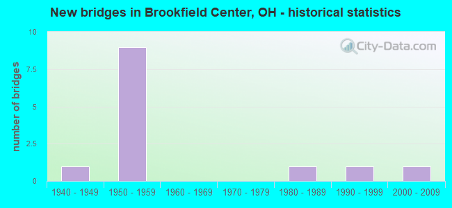
- New bridges - historical statistics
- 11940-1949
- 91950-1959
- 11980-1989
- 11990-1999
- 12000-2009


- Bridge Condition - Deck
- 18.2%Excellent
- 63.6%Good
- 9.1%Satisfactory
- 9.1%Fair

- Bridge Condition - Superstructure
- 18.2%Excellent
- 54.5%Good
- 9.1%Satisfactory
- 9.1%Fair
- 9.1%Poor

- Bridge Condition - Substructure
- 18.2%Excellent
- 18.2%Very good
- 27.3%Good
- 27.3%Satisfactory
- 9.1%Fair

- Bridge Condition - Channel
- 66.7%Very good
- 16.7%Good
- 16.7%Fair
Find on map >> Show street view
Structure Number: 7804806, Location: 1.91 MI W OF SR 7 (Lat: 41.230061, Lng: -80.604850), Route carried "on" structure: State highway 82, Year Built: 1957, Year Reconstructed: 2004, Status: Open, Structure Length: 5.21m (17.09ft), Average Daily Traffic: 6,164 (year 2015), Truck Traffic: 13%, Average Future Daily Traffic: 8,556 (year 2035), Design Load: HS 20+Mod, Features Intersected: OVER NORFOLK SOUTHERN RR
Minimum Vertical Clearance: 30+ m (98+ ft), Kilometerpoint: 40.620, Lanes on structure: 2, Base Highway Network: Yes, Owner: State Highway Agency, Approaching Roadway Width: 7.3m (24.0ft), Skew: 2 degrees, Material/Design: Steel continuous, Design/Construction: Stringer/Multi-beam, Number Of Spans In Main Unit: 3, Length of Maximum Span: 21.3m (69.9ft), Curb-To-Curb Width: 12.2m (40.0ft), Out-to-Out Width: 13.1m (43.0ft)
Condition: Deck: Good, Superstructure: Good, Substructure: Good, Operating Rating: 42.1 metric tons, Method Used To Determine Operating Rating: Load Factor (LF) rating reported by rating factor (RF) method using MS18 loading, Inventory Rating: 32.4 metric tons, Method Used To Determine Inventory Rating: Load Factor (LF) rating reported by rating factor (RF) method using MS18 loading, Structural Evaluation: Better than present minimum criteria, Deck Geometry: Better than present minimum criteria, Underclear: Equal to present minimum criteria, Approach Roadway Alignment: Equal to present desirable criteria, Designated Inspection Frequency: Every 24 months, Inspection Date: August 2021, Deck Structure Type: Concrete Cast-file-Place, Wearing Surface/Protective System: Wearing Surface: Monolithic Concrete, Membrane: Epoxy, Deck Protection: Epoxy Coated Reinforcing
Find on map >> Show street view
Structure Number: 780483, Location: 1.91 MI W OF SR 7 (Lat: 41.229750, Lng: -80.604739), Route carried "on" structure: State highway 82, Year Built: 1957, Year Reconstructed: 2004, Status: Open, Structure Length: 5.21m (17.09ft), Average Daily Traffic: 6,164 (year 2015), Truck Traffic: 13%, Average Future Daily Traffic: 8,556 (year 2035), Design Load: HS 20+Mod, Features Intersected: OVER NORFOLK SOUTHERN RR
Minimum Vertical Clearance: 30+ m (98+ ft), Kilometerpoint: 40.620, Lanes on structure: 2, Base Highway Network: Yes, Owner: State Highway Agency, Approaching Roadway Width: 7.3m (24.0ft), Skew: 2 degrees, Material/Design: Steel continuous, Design/Construction: Stringer/Multi-beam, Number Of Spans In Main Unit: 3, Length of Maximum Span: 21.3m (69.9ft), Curb-To-Curb Width: 12.2m (40.0ft), Out-to-Out Width: 13.1m (43.0ft)
Condition: Deck: Good, Superstructure: Good, Substructure: Good, Operating Rating: 42.1 metric tons, Method Used To Determine Operating Rating: Load Factor (LF) rating reported by rating factor (RF) method using MS18 loading, Inventory Rating: 32.4 metric tons, Method Used To Determine Inventory Rating: Load Factor (LF) rating reported by rating factor (RF) method using MS18 loading, Structural Evaluation: Better than present minimum criteria, Deck Geometry: Better than present minimum criteria, Underclear: High priority of corrective action, Approach Roadway Alignment: Equal to present desirable criteria, Designated Inspection Frequency: Every 24 months, Inspection Date: August 2021, Deck Structure Type: Concrete Cast-file-Place, Wearing Surface/Protective System: Wearing Surface: Monolithic Concrete, Membrane: Epoxy, Deck Protection: Epoxy Coated Reinforcing
Find on map >> Show street view
Structure Number: 7804865, Location: 1.74 MI W OF SR 7 (Lat: 41.229711, Lng: -80.601400), Route carried "on" structure: State highway 82, Year Built: 1957, Year Reconstructed: 2004, Status: Open, Structure Length: 4.03m (13.22ft), Average Daily Traffic: 6,164 (year 2015), Truck Traffic: 13%, Average Future Daily Traffic: 8,556 (year 2035), Design Load: HS 25 or greater, Features Intersected: OVER ALBRIGHT-MCKAY RD
Minimum Vertical Clearance: 30+ m (98+ ft), Kilometerpoint: 40.893, Lanes on structure: 2, Lanes under structure: 2, Base Highway Network: Yes, Owner: State Highway Agency, Approaching Roadway Width: 11.9m (39.0ft), Skew: 1 degrees, Material/Design: Steel continuous, Design/Construction: Stringer/Multi-beam, Number Of Spans In Main Unit: 3, Length of Maximum Span: 15.2m (49.9ft), Curb-To-Curb Width: 11.9m (39.0ft), Out-to-Out Width: 12.8m (42.0ft)
Condition: Deck: Good, Superstructure: Good, Substructure: Very good, Operating Rating: 42.1 metric tons, Method Used To Determine Operating Rating: Load Factor (LF) rating reported by rating factor (RF) method using MS18 loading, Inventory Rating: 32.4 metric tons, Method Used To Determine Inventory Rating: Load Factor (LF) rating reported by rating factor (RF) method using MS18 loading, Structural Evaluation: Better than present minimum criteria, Deck Geometry: Better than present minimum criteria, Underclear: Meets minimum limits, Approach Roadway Alignment: Equal to present desirable criteria, Designated Inspection Frequency: Every 24 months, Inspection Date: August 2021, Deck Structure Type: Concrete Cast-file-Place, Wearing Surface/Protective System: Wearing Surface: Monolithic Concrete, Membrane: Epoxy, Deck Protection: Epoxy Coated Reinforcing
Find on map >> Show street view
Structure Number: 7804954, Location: 1.74 MI W OF SR 7 (Lat: 41.229431, Lng: -80.601519), Route carried "on" structure: State highway 82, Year Built: 1957, Year Reconstructed: 2004, Status: Open, Structure Length: 4.03m (13.22ft), Average Daily Traffic: 6,164 (year 2015), Truck Traffic: 13%, Average Future Daily Traffic: 8,556 (year 2035), Design Load: HS 25 or greater, Features Intersected: OVER ALBRIGHT-MCKAY RD
Minimum Vertical Clearance: 30+ m (98+ ft), Kilometerpoint: 40.893, Lanes on structure: 2, Lanes under structure: 2, Base Highway Network: Yes, Owner: State Highway Agency, Approaching Roadway Width: 11.9m (39.0ft), Skew: 1 degrees, Material/Design: Steel continuous, Design/Construction: Stringer/Multi-beam, Number Of Spans In Main Unit: 3, Length of Maximum Span: 15.2m (49.9ft), Curb-To-Curb Width: 11.9m (39.0ft), Out-to-Out Width: 12.8m (42.0ft)
Condition: Deck: Good, Superstructure: Good, Substructure: Very good, Operating Rating: 42.1 metric tons, Method Used To Determine Operating Rating: Load Factor (LF) rating reported by rating factor (RF) method using MS18 loading, Inventory Rating: 32.4 metric tons, Method Used To Determine Inventory Rating: Load Factor (LF) rating reported by rating factor (RF) method using MS18 loading, Structural Evaluation: Better than present minimum criteria, Deck Geometry: Better than present minimum criteria, Underclear: Meets minimum limits, Approach Roadway Alignment: Equal to present desirable criteria, Designated Inspection Frequency: Every 24 months, Inspection Date: August 2021, Deck Structure Type: Concrete Cast-file-Place, Wearing Surface/Protective System: Wearing Surface: Monolithic Concrete, Membrane: Epoxy, Deck Protection: Epoxy Coated Reinforcing
Find on map >> Show street view
Structure Number: 7804989, Location: 1.69 MI W OF SR 7 (Lat: 41.229631, Lng: -80.600619), Route carried "on" structure: State highway 82, Year Built: 1957, Year Reconstructed: 2004, Status: Open, Structure Length: 3.01m (9.88ft), Average Daily Traffic: 6,164 (year 2015), Truck Traffic: 13%, Average Future Daily Traffic: 8,556 (year 2035), Design Load: HS 25 or greater, Features Intersected: LITTLE YANKEE RUN
Minimum Vertical Clearance: 30+ m (98+ ft), Kilometerpoint: 40.974, Lanes on structure: 2, Base Highway Network: Yes, Owner: State Highway Agency, Approaching Roadway Width: 11.9m (39.0ft), Skew: 2 degrees, Material/Design: Concrete continuous, Design/Construction: Slab, Number Of Spans In Main Unit: 3, Length of Maximum Span: 11.4m (37.4ft), Curb-To-Curb Width: 11.9m (39.0ft), Out-to-Out Width: 12.8m (42.0ft)
Condition: Deck: Good, Superstructure: Good, Substructure: Satisfactory, Channel: Very good, Operating Rating: 42.1 metric tons, Method Used To Determine Operating Rating: Load Factor (LF) rating reported by rating factor (RF) method using MS18 loading, Inventory Rating: 32.4 metric tons, Method Used To Determine Inventory Rating: Load Factor (LF) rating reported by rating factor (RF) method using MS18 loading, Structural Evaluation: Equal to present minimum criteria, Deck Geometry: Better than present minimum criteria, Waterway Adequacy: Equal to present desirable criteria, Approach Roadway Alignment: Equal to present desirable criteria, Designated Inspection Frequency: Every 12 months, Inspection Date: August 2021, Deck Structure Type: Concrete Cast-file-Place, Wearing Surface/Protective System: Wearing Surface: Monolithic Concrete, Membrane: Epoxy, Deck Protection: Epoxy Coated Reinforcing
Find on map >> Show street view
Structure Number: 7805012, Location: 1.69 MI W OF SR 7 (Lat: 41.229331, Lng: -80.600561), Route carried "on" structure: State highway 82, Year Built: 1957, Year Reconstructed: 2004, Status: Open, Structure Length: 3.01m (9.88ft), Average Daily Traffic: 6,164 (year 2015), Truck Traffic: 13%, Average Future Daily Traffic: 8,556 (year 2035), Design Load: HS 25 or greater, Features Intersected: LITTLE YANKEE RUN
Minimum Vertical Clearance: 30+ m (98+ ft), Kilometerpoint: 40.974, Lanes on structure: 2, Base Highway Network: Yes, Owner: State Highway Agency, Approaching Roadway Width: 11.9m (39.0ft), Skew: 2 degrees, Material/Design: Concrete continuous, Design/Construction: Slab, Number Of Spans In Main Unit: 3, Length of Maximum Span: 11.4m (37.4ft), Curb-To-Curb Width: 11.9m (39.0ft), Out-to-Out Width: 12.8m (42.0ft)
Condition: Deck: Good, Superstructure: Good, Substructure: Good, Channel: Very good, Operating Rating: 42.1 metric tons, Method Used To Determine Operating Rating: Load Factor (LF) rating reported by rating factor (RF) method using MS18 loading, Inventory Rating: 32.4 metric tons, Method Used To Determine Inventory Rating: Load Factor (LF) rating reported by rating factor (RF) method using MS18 loading, Structural Evaluation: Better than present minimum criteria, Deck Geometry: Better than present minimum criteria, Waterway Adequacy: Equal to present desirable criteria, Approach Roadway Alignment: Equal to present desirable criteria, Designated Inspection Frequency: Every 24 months, Inspection Date: August 2021, Deck Structure Type: Concrete Cast-file-Place, Wearing Surface/Protective System: Wearing Surface: Monolithic Concrete, Membrane: Epoxy, Deck Protection: Epoxy Coated Reinforcing
Find on map >> Show street view
Structure Number: 7836007, Location: 0.1 MI. W. OF C.H. 167-C (Lat: 41.235939, Lng: -80.602389), Route carried "on" structure: County highway C0329, Year Built: 1942, Status: Open, Structure Length: 1.62m (5.31ft), Average Daily Traffic: 3,287 (year 2015), Truck Traffic: 5%, Average Future Daily Traffic: 4,562 (year 2035), Design Load: H 20, Features Intersected: LITTLE YANKEE RUN, Facility Carried by Structure: WARREN SHARON ROAD
Minimum Vertical Clearance: 30+ m (98+ ft), Kilometerpoint: 0.129, Lanes on structure: 2, Owner: County Highway Agency, Approaching Roadway Width: 7.9m (25.9ft), Material/Design: Concrete continuous, Design/Construction: Slab, Number Of Spans In Main Unit: 2, Length of Maximum Span: 7.3m (24.0ft), Curb-To-Curb Width: 8.3m (27.2ft), Out-to-Out Width: 8.3m (27.2ft)
Condition: Deck: Satisfactory, Superstructure: Satisfactory, Substructure: Satisfactory, Channel: Very good, Operating Rating: 42.1 metric tons, Method Used To Determine Operating Rating: Load Factor (LF) rating reported by rating factor (RF) method using MS18 loading, Inventory Rating: 25.9 metric tons, Method Used To Determine Inventory Rating: Load Factor (LF) rating reported by rating factor (RF) method using MS18 loading, Structural Evaluation: Equal to present minimum criteria, Deck Geometry: High priority of corrective action, Waterway Adequacy: Better than present minimum criteria, Approach Roadway Alignment: Better than present minimum criteria, Designated Inspection Frequency: Every 12 months, Inspection Date: April 2021, Deck Structure Type: Concrete Cast-file-Place, Wearing Surface/Protective System: Wearing Surface: Bituminous
Find on map >> Show street view
Structure Number: 7840926, Location: 0.9 MI. E. OF S.R. 7 (Lat: 41.260639, Lng: -80.553469), Route carried "on" structure: County highway C169A, Year Built: 1982, Status: Open, Structure Length: 2.10m (6.89ft), Average Daily Traffic: 491 (year 2015), Truck Traffic: 8%, Average Future Daily Traffic: 682 (year 2035), Design Load: HS 20+Mod, Features Intersected: YANKEE RUN, Facility Carried by Structure: COUNTY ROAD 169-A
Minimum Vertical Clearance: 30+ m (98+ ft), Kilometerpoint: 0.225, Lanes on structure: 2, Owner: County Highway Agency, Approaching Roadway Width: 6.1m (20.0ft), Material/Design: Prestressed concrete, Design/Construction: Box Beam or Girders - Multiple, Number Of Spans In Main Unit: 1, Length of Maximum Span: 19.8m (65.0ft), Curb-To-Curb Width: 9.2m (30.2ft), Out-to-Out Width: 9.8m (32.2ft)
Condition: Deck: Fair, Superstructure: Fair, Substructure: Fair, Channel: Fair, Operating Rating: 51.8 metric tons, Method Used To Determine Operating Rating: Load Factor (LF) rating reported by rating factor (RF) method using MS18 loading, Inventory Rating: 32.4 metric tons, Method Used To Determine Inventory Rating: Load Factor (LF) rating reported by rating factor (RF) method using MS18 loading, Structural Evaluation: Somewhat better than minimum adequacy, Deck Geometry: Equal to present minimum criteria, Waterway Adequacy: Equal to present desirable criteria, Approach Roadway Alignment: Equal to present desirable criteria, Designated Inspection Frequency: Every 12 months, Inspection Date: April 2021, Deck Structure Type: Other, Wearing Surface/Protective System: Wearing Surface: Bituminous
Find on map >> Show street view
Structure Number: 7840969, Location: 0.5 MI.E.CR 43 (Lat: 41.250639, Lng: -80.605631), Route carried "on" structure: County highway C168A, Year Built: 1991, Status: Open, Structure Length: 4.91m (16.11ft), Average Daily Traffic: 613 (year 2015), Truck Traffic: 8%, Average Future Daily Traffic: 851 (year 2035), Design Load: HS 20+Mod, Features Intersected: NORFOLK SOUTHERN RR, Facility Carried by Structure: MERWIN CHASE ROAD
Minimum Vertical Clearance: 30+ m (98+ ft), Kilometerpoint: 0.193, Lanes on structure: 2, Owner: County Highway Agency, Approaching Roadway Width: 7.3m (24.0ft), Skew: 1 degrees, Material/Design: Prestressed concrete, Design/Construction: Box Beam or Girders - Multiple, Number Of Spans In Main Unit: 3, Length of Maximum Span: 19.8m (65.0ft), Curb-To-Curb Width: 9.1m (29.9ft), Out-to-Out Width: 9.4m (30.8ft)
Condition: Deck: Excellent, Superstructure: Excellent, Substructure: Excellent, Operating Rating: 55.1 metric tons, Method Used To Determine Operating Rating: Load Factor (LF) rating reported by rating factor (RF) method using MS18 loading, Inventory Rating: 38.9 metric tons, Method Used To Determine Inventory Rating: Load Factor (LF) rating reported by rating factor (RF) method using MS18 loading, Structural Evaluation: Superior to present desirable criteria, Deck Geometry: Equal to present minimum criteria, Underclear: Superior to present desirable criteria, Approach Roadway Alignment: Equal to present desirable criteria, Designated Inspection Frequency: Every 24 months, Inspection Date: April 2021, Deck Structure Type: Concrete Cast-file-Place, Wearing Surface/Protective System: Wearing Surface: Monolithic Concrete, Membrane: Epoxy, Deck Protection: Epoxy Coated Reinforcing
Find on map >> Show street view
Structure Number: 7841094, Location: 2700 FEET WEST OF TH321 (Lat: 41.213739, Lng: -80.592439), Route carried "on" structure: County highway C174B, Year Built: 2006, Status: Open, Structure Length: 1.98m (6.50ft), Average Daily Traffic: 778 (year 2015), Truck Traffic: 7%, Average Future Daily Traffic: 1,080 (year 2035), Design Load: HS 20+Mod, Features Intersected: LITTLE YANKEE RUN, Facility Carried by Structure: STEWART SHARON RD
Minimum Vertical Clearance: 30+ m (98+ ft), Kilometerpoint: 0.048, Lanes on structure: 2, Owner: County Highway Agency, Approaching Roadway Width: 7.9m (25.9ft), Skew: 1 degrees, Material/Design: Prestressed concrete, Design/Construction: Box Beam or Girders - Multiple, Number Of Spans In Main Unit: 1, Length of Maximum Span: 19.2m (63.0ft), Curb-To-Curb Width: 8.6m (28.2ft), Out-to-Out Width: 8.6m (28.2ft)
Condition: Deck: Excellent, Superstructure: Excellent, Substructure: Excellent, Channel: Very good, Operating Rating: 42.1 metric tons, Method Used To Determine Operating Rating: Load Factor (LF) rating reported by rating factor (RF) method using MS18 loading, Inventory Rating: 32.4 metric tons, Method Used To Determine Inventory Rating: Load Factor (LF) rating reported by rating factor (RF) method using MS18 loading, Structural Evaluation: Equal to present desirable criteria, Deck Geometry: Somewhat better than minimum adequacy, Waterway Adequacy: Better than present minimum criteria, Approach Roadway Alignment: Equal to present minimum criteria, Designated Inspection Frequency: Every 24 months, Inspection Date: April 2021, Deck Structure Type: Concrete Cast-file-Place, Wearing Surface/Protective System: Wearing Surface: Bituminous, Membrane: Preformed Fabric
Find on map >> Show street view
Structure Number: 7841132, Location: 2100 FT SOUTH OF CH329 (Lat: 41.230000, Lng: -80.600939), Route carried "on" structure: County highway C0167, Year Built: 1951, Year Reconstructed: 1999, Status: Open, Structure Length: 1.28m (4.20ft), Average Daily Traffic: 485 (year 2015), Truck Traffic: 7%, Average Future Daily Traffic: 673 (year 2035), Design Load: H 15, Features Intersected: LITTLE YANKEE RUN, Facility Carried by Structure: ALBRIGHT MCKAY RD.
Minimum Vertical Clearance: 30+ m (98+ ft), Kilometerpoint: 0.016, Lanes on structure: 1, Owner: County Highway Agency, Approaching Roadway Width: 5.8m (19.0ft), Material/Design: Steel, Design/Construction: Truss - Thru, Number Of Spans In Main Unit: 1, Length of Maximum Span: 12.5m (41.0ft), Curb-To-Curb Width: 5.3m (17.4ft), Out-to-Out Width: 5.4m (17.7ft)
Condition: Deck: Good, Superstructure: Poor, Substructure: Satisfactory, Channel: Good, Operating Rating: 71.3 metric tons, Method Used To Determine Operating Rating: Load Factor (LF) rating reported by rating factor (RF) method using MS18 loading, Inventory Rating: 51.8 metric tons, Method Used To Determine Inventory Rating: Load Factor (LF) rating reported by rating factor (RF) method using MS18 loading, Structural Evaluation: Meets minimum limits, Deck Geometry: High priority of replacement, Waterway Adequacy: Better than present minimum criteria, Approach Roadway Alignment: Meets minimum limits, Designated Inspection Frequency: Every 12 months, Critical Feature Inspection Frequency: Every 24 months, Inspection Date: April 2021, Critical Feature Inspection Date: April 2021, Deck Structure Type: Corrugated Steel, Wearing Surface/Protective System: Wearing Surface: Bituminous
Find on map >> Show street view
Structure Number: 7804865, Location: 1.74 MI W OF SR 7 (Lat: 41.229711, Lng: -80.601400), Route carried "under" structure: County highway 167, Year Built: 1957, Structure Length: 0. m, Average Daily Traffic: 485 (year 2015), Truck Traffic: 7%, Features Intersected: SR 82, Facility Carried by Structure: SR 82
Minimum Vertical Clearance: 4.80m (15.75ft), Kilometerpoint: 0.740, Lanes on structure: 2, Lanes under structure: 2, Material/Design: Steel continuous, Design/Construction: Stringer/Multi-beam, Length of Maximum Span: 15.2m (49.9ft)
Find on map >> Show street view
Structure Number: 7804954, Location: 1.74 MI W OF SR 7 (Lat: 41.229431, Lng: -80.601519), Route carried "under" structure: County highway 167, Year Built: 1957, Structure Length: 0. m, Average Daily Traffic: 485 (year 2015), Truck Traffic: 7%, Features Intersected: SR 82, Facility Carried by Structure: SR 82
Minimum Vertical Clearance: 4.42m (14.50ft), Kilometerpoint: 77.249, Lanes on structure: 2, Lanes under structure: 2, Material/Design: Steel continuous, Design/Construction: Stringer/Multi-beam, Length of Maximum Span: 15.2m (49.9ft)