Bridge Statistics for Brownlee Park, Michigan (MI)
Condition, Traffic, Stress, Structural Evaluation, Project Costs
- National Bridge Inventory (NBI) Statistics
- 12Number of bridges
- 125ft / 38.3mTotal length
- 247,918Total average daily traffic
- 52,752Total average daily truck traffic
- National Bridge Inventory (NBI) Registered Bridges for Brownlee Park
- No street view available for this location
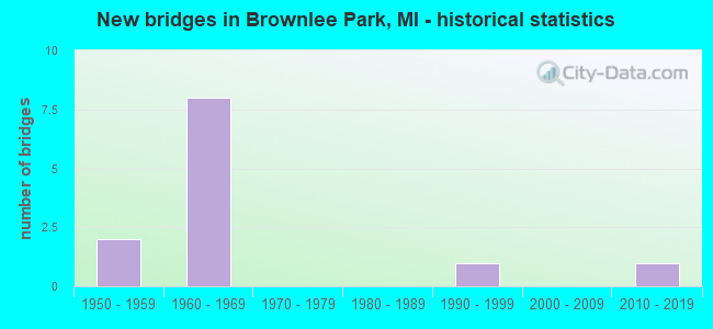
- New bridges - historical statistics
- 21950-1959
- 81960-1969
- 11990-1999
- 12010-2019


- Bridge Condition - Deck
- 20.0%Good
- 60.0%Satisfactory
- 20.0%Fair

- Bridge Condition - Superstructure
- 20.0%Very good
- 40.0%Satisfactory
- 40.0%Fair

- Bridge Condition - Substructure
- 20.0%Very good
- 60.0%Satisfactory
- 20.0%Poor

- Bridge Condition - Channel
- 33.3%Good
- 66.7%Fair
Find on map >> Show street view
Structure Number: 1256, Location: 3.7 MI E OF M-66 (Lat: 42.289483, Lng: -85.113633), Route carried "on" structure: Interstate 94, Year Built: 1960, Status: Open, Structure Length: 8.39m (27.53ft), Average Daily Traffic: 22,400 (year 2010), Truck Traffic: 22%, Average Future Daily Traffic: 24,300 (year 2030), Design Load: HS 20, Features Intersected: KALAMAZOO RIVER
Minimum Vertical Clearance: 30.48m (100.00ft), Kilometerpoint: 16.166, Lanes on structure: 2, Base Highway Network: Yes (Inventory Route: 129, Subroute: 6), Owner: State Highway Agency, Approaching Roadway Width: 11.6m (38.1ft), Skew: 3 degrees, Material/Design: Concrete continuous, Design/Construction: Tee Beam, Number Of Spans In Main Unit: 4, Length of Maximum Span: 23.8m (78.1ft), Curb-To-Curb Width: 10.4m (34.1ft), Out-to-Out Width: 11.4m (37.4ft)
Condition: Deck: Satisfactory, Superstructure: Satisfactory, Substructure: Satisfactory, Channel: Fair, Operating Rating: 53.5 metric tons, Method Used To Determine Operating Rating: Load Factor (LF) rating reported by rating factor (RF) method using MS18 loading, Inventory Rating: 32.1 metric tons, Method Used To Determine Inventory Rating: Load Factor (LF) rating reported by rating factor (RF) method using MS18 loading, Structural Evaluation: Equal to present minimum criteria, Deck Geometry: Meets minimum limits, Waterway Adequacy: Equal to present desirable criteria, Approach Roadway Alignment: Better than present minimum criteria, Designated Inspection Frequency: Every 24 months, Inspection Date: July 2021, Deck Structure Type: Concrete Cast-file-Place, Wearing Surface/Protective System: Wearing Surface: Latex Concrete
Find on map >> Show street view
Structure Number: 1257, Location: 3.7 MI E OF M-66 (Lat: 42.289617, Lng: -85.114033), Route carried "on" structure: Interstate 94, Year Built: 1960, Status: Open, Structure Length: 8.39m (27.53ft), Average Daily Traffic: 22,400 (year 2010), Truck Traffic: 22%, Average Future Daily Traffic: 24,300 (year 2030), Design Load: HS 20, Features Intersected: KALAMAZOO RIVER
Minimum Vertical Clearance: 30.48m (100.00ft), Kilometerpoint: 16.133, Lanes on structure: 2, Base Highway Network: Yes (Inventory Route: 129, Subroute: 9), Owner: State Highway Agency, Approaching Roadway Width: 11.8m (38.7ft), Skew: 3 degrees, Material/Design: Concrete continuous, Design/Construction: Tee Beam, Number Of Spans In Main Unit: 4, Length of Maximum Span: 23.8m (78.1ft), Curb-To-Curb Width: 10.4m (34.1ft), Out-to-Out Width: 11.4m (37.4ft)
Condition: Deck: Satisfactory, Superstructure: Satisfactory, Substructure: Satisfactory, Channel: Fair, Operating Rating: 53.5 metric tons, Method Used To Determine Operating Rating: Load Factor (LF) rating reported by rating factor (RF) method using MS18 loading, Inventory Rating: 31.8 metric tons, Method Used To Determine Inventory Rating: Load Factor (LF) rating reported by rating factor (RF) method using MS18 loading, Structural Evaluation: Equal to present minimum criteria, Deck Geometry: Meets minimum limits, Waterway Adequacy: Equal to present desirable criteria, Approach Roadway Alignment: Better than present minimum criteria, Designated Inspection Frequency: Every 24 months, Inspection Date: July 2021, Deck Structure Type: Concrete Cast-file-Place, Wearing Surface/Protective System: Wearing Surface: Latex Concrete
Find on map >> Show street view
Structure Number: 1267, Location: 1.0 MI W OF I-94 BL (Lat: 42.291656, Lng: -85.108328), Route carried "on" structure: County highway , Year Built: 1960, Status: Open, Structure Length: 5.32m (17.45ft), Average Daily Traffic: 777 (year 1997), Truck Traffic: 3%, Average Future Daily Traffic: 847 (year 2000), Design Load: H 15, Features Intersected: I-94, Facility Carried by Structure: F DRIVE NORTH
Minimum Vertical Clearance: 30.48m (100.00ft), Kilometerpoint: 0.238, Lanes on structure: 2, Lanes under structure: 4, Owner: State Highway Agency, Approaching Roadway Width: 6.4m (21.0ft), Skew: 3 degrees, Material/Design: Steel, Design/Construction: Stringer/Multi-beam, Number Of Spans In Main Unit: 2, Length of Maximum Span: 26.6m (87.3ft), Curb or Sidewalk Widths: Left: 0.2m (0.7ft), Right: 0.2m (0.7ft), Curb-To-Curb Width: 7.3m (24.0ft), Out-to-Out Width: 9.6m (31.5ft)
Condition: Deck: Satisfactory, Superstructure: Fair, Substructure: Poor, Operating Rating: 76.5 metric tons, Method Used To Determine Operating Rating: Load Factor (LF) rating reported by rating factor (RF) method using MS18 loading, Inventory Rating: 45.7 metric tons, Method Used To Determine Inventory Rating: Load Factor (LF) rating reported by rating factor (RF) method using MS18 loading, Structural Evaluation: Meets minimum limits, Deck Geometry: Meets minimum limits, Underclear: Meets minimum limits, Approach Roadway Alignment: Equal to present desirable criteria, Designated Inspection Frequency: Every 24 months, Other Special Inspection Frequency: Every 8 months, Inspection Date: August 2021, Other Special Inspection Date: December 2021, Bridge Improvement Cost: $125,000, Deck Structure Type: Concrete Cast-file-Place, Wearing Surface/Protective System: Wearing Surface: Monolithic Concrete
Find on map >> Show street view
Structure Number: 1268, Location: 4.6 MI W OF I-69 (Lat: 42.299283, Lng: -85.085369), Route carried "on" structure: Business Interstate 94, Year Built: 1960, Status: Open, Structure Length: 9.49m (31.14ft), Average Daily Traffic: 13,099 (year 2007), Truck Traffic: 2%, Average Future Daily Traffic: 18,677 (year 2018), Design Load: HS 20, Features Intersected: I-94
Minimum Vertical Clearance: 30.48m (100.00ft), Kilometerpoint: 8.287, Lanes on structure: 3, Lanes under structure: 5, Base Highway Network: Yes (Inventory Route: 313, Subroute: 75), Owner: State Highway Agency, Approaching Roadway Width: 11.1m (36.4ft), Skew: 3 degrees, Material/Design: Concrete continuous, Design/Construction: Tee Beam, Number Of Spans In Main Unit: 4, Length of Maximum Span: 31.7m (104.0ft), Curb-To-Curb Width: 13.1m (43.0ft), Out-to-Out Width: 14.0m (45.9ft)
Condition: Deck: Fair, Superstructure: Fair, Substructure: Satisfactory, Operating Rating: 66.1 metric tons, Method Used To Determine Operating Rating: Load Factor (LF) rating reported by rating factor (RF) method using MS18 loading, Inventory Rating: 39.5 metric tons, Method Used To Determine Inventory Rating: Load Factor (LF) rating reported by rating factor (RF) method using MS18 loading, Structural Evaluation: Somewhat better than minimum adequacy, Deck Geometry: Meets minimum limits, Underclear: High priority of corrective action, Approach Roadway Alignment: Equal to present desirable criteria, Designated Inspection Frequency: Every 24 months, Inspection Date: August 2021, Bridge Improvement Cost: $119,000, Deck Structure Type: Concrete Cast-file-Place, Wearing Surface/Protective System: Wearing Surface: Latex Concrete
Find on map >> Show street view
Structure Number: 1307, Location: EMMETT TWP SEC 8 (Lat: 42.307964, Lng: -85.145297), Route carried "on" structure: County highway 2011, Year Built: 2017, Status: Open, Structure Length: 6.71m (22.01ft), Average Daily Traffic: 1,086 (year 2015), Truck Traffic: 4%, Average Future Daily Traffic: 2,288 (year 2035), Design Load: Greater than HL93, Features Intersected: KALAMAZOO RIVER, Facility Carried by Structure: RAYMOND ROAD
Minimum Vertical Clearance: 30.48m (100.00ft), Kilometerpoint: 1.436, Lanes on structure: 2, Owner: County Highway Agency, Approaching Roadway Width: 9.1m (29.9ft), Skew: 4 degrees, Material/Design: Prestressed concrete, Design/Construction: Stringer/Multi-beam, Number Of Spans In Main Unit: 3, Length of Maximum Span: 34.6m (113.5ft), Curb-To-Curb Width: 9.9m (32.5ft), Out-to-Out Width: 10.7m (35.1ft)
Condition: Deck: Good, Superstructure: Very good, Substructure: Very good, Channel: Good, Operating Rating: 79.1 metric tons, Method Used To Determine Operating Rating: Load and Resistance Factor Rating (LRFR) rating reported by rating factor(RF) method using HL-93 loadings, Inventory Rating: 60.9 metric tons, Method Used To Determine Inventory Rating: Load and Resistance Factor Rating (LRFR) rating reported by rating factor(RF) method using HL-93 loadings, Structural Evaluation: Equal to present desirable criteria, Deck Geometry: Somewhat better than minimum adequacy, Waterway Adequacy: Equal to present desirable criteria, Approach Roadway Alignment: Equal to present desirable criteria, Designated Inspection Frequency: Every 24 months, Inspection Date: July 2021, Deck Structure Type: Concrete Cast-file-Place, Wearing Surface/Protective System: Wearing Surface: Bituminous, Deck Protection: Epoxy Coated Reinforcing
Find on map >> Show street view
Structure Number: 1265, Location: 3.2 MI E OF M-66 (Lat: 42.287058, Lng: -85.120475), Route carried "under" structure: County highway , Year Built: 1959, Structure Length: 0. m, Average Daily Traffic: 940 (year 1974), Truck Traffic: 3%, Features Intersected: 9 MILE ROAD, Facility Carried by Structure: I-94 EB
Minimum Vertical Clearance: 4.50m (14.76ft), Kilometerpoint: 2.862, Lanes on structure: 2, Lanes under structure: 2, Material/Design: Concrete, Design/Construction: Tee Beam, Length of Maximum Span: 13.5m (44.3ft)
Find on map >> Show street view
Structure Number: 1266, Location: 3.2 MI E OF M-66 (Lat: 42.287342, Lng: -85.120467), Route carried "under" structure: County highway , Year Built: 1959, Structure Length: 0. m, Average Daily Traffic: 2,130 (year 1995), Truck Traffic: 3%, Features Intersected: 9 MILE ROAD, Facility Carried by Structure: I-94 WB
Minimum Vertical Clearance: 4.44m (14.57ft), Kilometerpoint: 2.894, Lanes on structure: 2, Lanes under structure: 2, Material/Design: Concrete, Design/Construction: Tee Beam, Length of Maximum Span: 13.5m (44.3ft)
Find on map >> Show street view
Structure Number: 1267, Location: 1.0 MI W OF I-94 BL (Lat: 42.291656, Lng: -85.108328), Route carried "under" structure: Interstate 94, Year Built: 1960, Structure Length: 0. m, Average Daily Traffic: 44,060 (year 2007), Truck Traffic: 24%, Features Intersected: I-94, Facility Carried by Structure: F DRIVE NORTH
Minimum Vertical Clearance: 6.10m (20.01ft), Kilometerpoint: 16.667, Lanes on structure: 2, Lanes under structure: 4, Material/Design: Steel, Design/Construction: Stringer/Multi-beam, Length of Maximum Span: 26.6m (87.3ft)
Find on map >> Show street view
Structure Number: 1268, Location: 4.6 MI W OF I-69 (Lat: 42.299283, Lng: -85.085369), Route carried "under" structure: Interstate 94, Year Built: 1960, Structure Length: 0. m, Average Daily Traffic: 48,478 (year 2007), Truck Traffic: 22%, Features Intersected: I-94
Minimum Vertical Clearance: 5.77m (18.93ft), Kilometerpoint: 18.745, Lanes on structure: 3, Lanes under structure: 5, Material/Design: Concrete continuous, Design/Construction: Tee Beam, Length of Maximum Span: 31.7m (104.0ft)
Find on map >> Show street view
Structure Number: 1269, Location: 0.2 MI E OF I-94 BL (Lat: 42.299828, Lng: -85.081603), Route carried "under" structure: Interstate 94, Year Built: 1960, Structure Length: 0. m, Average Daily Traffic: 48,478 (year 2007), Truck Traffic: 22%, Features Intersected: I-94, Facility Carried by Structure: M-311(11 MILE RD)
Minimum Vertical Clearance: 6.10m (20.01ft), Kilometerpoint: 19.062, Lanes on structure: 2, Lanes under structure: 6, Material/Design: Concrete continuous, Design/Construction: Tee Beam, Length of Maximum Span: 24.7m (81.0ft)
Find on map >> Show street view
Structure Number: 1272, Location: 1.2 MI W OF I-94 BL (Lat: 42.291500, Lng: -85.108697), Route carried "under" structure: Interstate 94, Year Built: 1960, Structure Length: 0. m, Average Daily Traffic: 44,060 (year 2007), Truck Traffic: 24%, Features Intersected: I-94, Facility Carried by Structure: MDOT RR CORRIDOR
Minimum Vertical Clearance: 4.88m (16.01ft), Kilometerpoint: 16.632, Lanes under structure: 4, Material/Design: Steel, Design/Construction: Stringer/Multi-beam, Length of Maximum Span: 25.9m (85.0ft)
Find on map >> Show street view
Structure Number: 1318, Location: EMMETT TWP SEC 15 (Lat: 42.291128, Lng: -85.116647), Route carried "under" structure: County highway , Year Built: 1990, Structure Length: 0. m, Average Daily Traffic: 10 (year 1990), Features Intersected: KALAMAZOO RV&PARK ACCESS, Facility Carried by Structure: 9 MILE R0AD
Minimum Vertical Clearance: 4.11m (13.48ft), Kilometerpoint: 0.000, Lanes on structure: 2, Lanes under structure: 2, Material/Design: Prestressed concrete, Design/Construction: Stringer/Multi-beam, Length of Maximum Span: 30.1m (98.8ft)