Bridge Statistics for Burkeville, Virginia (VA)
Condition, Traffic, Stress, Structural Evaluation, Project Costs
- National Bridge Inventory (NBI) Statistics
- 28Number of bridges
- 299ft / 90.5mTotal length
- $12,168,000Total costs
- 85,022Total average daily traffic
- 9,859Total average daily truck traffic
- National Bridge Inventory (NBI) Registered Bridges for Burkeville
- No street view available for this location
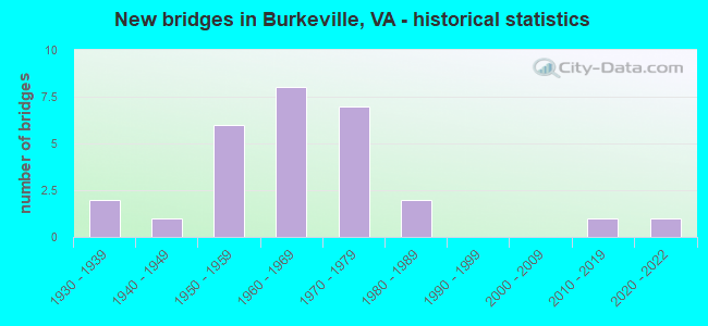
- New bridges - historical statistics
- 21930-1939
- 11940-1949
- 61950-1959
- 81960-1969
- 71970-1979
- 21980-1989
- 12010-2019
- 12020-2022

- Reconstructed bridges - Historical Statistics
- 21990-1999
- 02000-2009
- 22010-2019


- Bridge Condition - Deck
- 5.9%Very good
- 29.4%Good
- 35.3%Satisfactory
- 29.4%Fair

- Bridge Condition - Superstructure
- 11.8%Very good
- 11.8%Good
- 58.8%Satisfactory
- 11.8%Fair
- 5.9%Poor

- Bridge Condition - Substructure
- 29.4%Good
- 41.2%Satisfactory
- 29.4%Fair

- Bridge Condition - Channel
- 5.6%Very good
- 27.8%Good
- 22.2%Satisfactory
- 33.3%Fair
- 11.1%Poor

- Bridge Condition - Culverts
- 12.5%Very good
- 12.5%Good
- 37.5%Satisfactory
- 37.5%Fair
Find on map >> Show street view
Structure Number: 916, Location: 0.06 TO 613 & 0.03 TO 694 (Lat: 37.690050, Lng: -80.091772), Route carried "on" structure: State highway 18, Year Built: 1955, Status: Open, Structure Length: 7.39m (24.25ft), Average Daily Traffic: 929 (year 2020), Truck Traffic: 1%, Average Future Daily Traffic: 1,253 (year 2040), Design Load: HS 15, Features Intersected: POTTS CREEK, Facility Carried by Structure: POTTS CREEK ROAD
Minimum Vertical Clearance: 30+ m (98+ ft), Kilometerpoint: 21.955, Lanes on structure: 2, Owner: State Highway Agency, Approaching Roadway Width: 5.8m (19.0ft), Material/Design: Steel, Design/Construction: Stringer/Multi-beam, Number Of Spans In Main Unit: 4, Length of Maximum Span: 19.1m (62.7ft), Curb or Sidewalk Widths: Left: 0.5m (1.6ft), Right: 0.5m (1.6ft), Curb-To-Curb Width: 7.3m (24.0ft), Out-to-Out Width: 8.3m (27.2ft)
Condition: Deck: Fair, Superstructure: Satisfactory, Substructure: Satisfactory, Channel: Good, Operating Rating: 42.6 metric tons, Method Used To Determine Operating Rating: Load and Resistance Factor (LRFR), Inventory Rating: 32.7 metric tons, Method Used To Determine Inventory Rating: Load and Resistance Factor (LRFR), Structural Evaluation: Equal to present minimum criteria, Deck Geometry: Meets minimum limits, Waterway Adequacy: Better than present minimum criteria, Approach Roadway Alignment: Equal to present minimum criteria, Length Of Structure Improvement: 7.38m (24.21ft), Designated Inspection Frequency: Every 24 months, Inspection Date: September 2021, Bridge Improvement Cost: $235,000, Roadway Improvement Cost: $30,000, Total Project Cost: $285,000, Deck Structure Type: Concrete Cast-file-Place, Wearing Surface/Protective System: Wearing Surface: Latex Concrete
Find on map >> Show street view
Structure Number: 9124, Location: 2.40 from 632/.04 to 621 (Lat: 36.600394, Lng: -77.637933), Route carried "on" structure: County highway 633, Year Built: 1986, Status: Open, Structure Length: 0.82m (2.69ft), Average Daily Traffic: 710 (year 2020), Truck Traffic: 7%, Average Future Daily Traffic: 781 (year 2040), Design Load: HS 20, Features Intersected: Cattail Creek, Facility Carried by Structure: Pine Log Road
Minimum Vertical Clearance: 30+ m (98+ ft), Kilometerpoint: 7.273, Lanes on structure: 2, Owner: State Highway Agency, Approaching Roadway Width: 5.8m (19.0ft), Material/Design: Steel, Design/Construction: Culvert, Number Of Spans In Main Unit: 2, Length of Maximum Span: 3.5m (11.5ft)
Condition: Channel: Good, Culverts: Satisfactory, Operating Rating: 44.5 metric tons, Method Used To Determine Operating Rating: Load Factor (LF), Inventory Rating: 32.7 metric tons, Method Used To Determine Inventory Rating: Load Factor (LF), Structural Evaluation: Equal to present minimum criteria, Waterway Adequacy: Equal to present desirable criteria, Approach Roadway Alignment: Equal to present desirable criteria, Designated Inspection Frequency: Every 24 months, Inspection Date: April 2021
Find on map >> Show street view
Structure Number: 9125, Location: 1.25 MI TO INT. RTE. 627 (Lat: 36.633144, Lng: -77.644931), Route carried "on" structure: County highway 633, Year Built: 1977, Status: Open, Structure Length: 2.77m (9.09ft), Average Daily Traffic: 565 (year 2020), Truck Traffic: 12%, Average Future Daily Traffic: 622 (year 2040), Design Load: HS 20+Mod, Features Intersected: Fountains Creek, Facility Carried by Structure: Indep Church Rd
Minimum Vertical Clearance: 30+ m (98+ ft), Kilometerpoint: 11.070, Lanes on structure: 2, Owner: State Highway Agency, Approaching Roadway Width: 7.0m (23.0ft), Skew: 3 degrees, Material/Design: Concrete continuous, Design/Construction: Slab, Number Of Spans In Main Unit: 3, Length of Maximum Span: 10.7m (35.1ft), Curb-To-Curb Width: 7.7m (25.3ft), Out-to-Out Width: 8.5m (27.9ft)
Condition: Deck: Good, Superstructure: Good, Substructure: Good, Channel: Satisfactory, Operating Rating: 38.6 metric tons, Method Used To Determine Operating Rating: Load and Resistance Factor (LRFR), Inventory Rating: 29.8 metric tons, Method Used To Determine Inventory Rating: Load and Resistance Factor (LRFR), Structural Evaluation: Better than present minimum criteria, Deck Geometry: Meets minimum limits, Waterway Adequacy: Equal to present desirable criteria, Approach Roadway Alignment: Equal to present desirable criteria, Designated Inspection Frequency: Every 24 months, Inspection Date: August 2020, Deck Structure Type: Concrete Cast-file-Place, Wearing Surface/Protective System: Wearing Surface: Latex Concrete
Find on map >> Show street view
Structure Number: 9126, Location: 0.90 TO 611 / 0.20 TO 604 (Lat: 36.689217, Lng: -77.653664), Route carried "on" structure: County highway 633, Year Built: 1973, Status: Open, Structure Length: 0.64m (2.10ft), Average Daily Traffic: 144 (year 2017), Average Future Daily Traffic: 161 (year 2040), Design Load: HS 20, Features Intersected: Douglas Run, Facility Carried by Structure: Jones Mill Road
Minimum Vertical Clearance: 30+ m (98+ ft), Kilometerpoint: 17.989, Lanes on structure: 2, Owner: State Highway Agency, Approaching Roadway Width: 4.6m (15.1ft), Material/Design: Steel, Design/Construction: Culvert, Number Of Spans In Main Unit: 3, Length of Maximum Span: 1.8m (5.9ft)
Condition: Channel: Fair, Culverts: Fair, Operating Rating: 44.5 metric tons, Method Used To Determine Operating Rating: Load Factor (LF), Inventory Rating: 32.7 metric tons, Method Used To Determine Inventory Rating: Load Factor (LF), Structural Evaluation: Somewhat better than minimum adequacy, Waterway Adequacy: Better than present minimum criteria, Approach Roadway Alignment: Better than present minimum criteria, Designated Inspection Frequency: Every 24 months, Inspection Date: Febuary 2022
Find on map >> Show street view
Structure Number: 9151, Location: 0.70-Rt 779/0.48-Rt 696 (Lat: 36.585194, Lng: -79.105875), Route carried "on" structure: US 58, Year Built: 1933, Status: Open, Structure Length: 1.46m (4.79ft), Average Daily Traffic: 3,204 (year 2020), Truck Traffic: 16%, Average Future Daily Traffic: 4,486 (year 2040), Design Load: HS 20, Features Intersected: Winn's creek, Facility Carried by Structure: Philpott Road EBL
Minimum Vertical Clearance: 30+ m (98+ ft), Kilometerpoint: 502.653, Lanes on structure: 2, Base Highway Network: Yes, Owner: State Highway Agency, Approaching Roadway Width: 6.7m (22.0ft), Material/Design: Concrete, Design/Construction: Tee Beam, Number Of Spans In Main Unit: 1, Length of Maximum Span: 13.4m (44.0ft), Curb or Sidewalk Widths: Left: 0.2m (0.7ft), Right: 0.2m (0.7ft), Curb-To-Curb Width: 7.1m (23.3ft), Out-to-Out Width: 8.0m (26.2ft)
Condition: Deck: Satisfactory, Superstructure: Fair, Substructure: Good, Channel: Satisfactory, Operating Rating: 44.5 metric tons, Method Used To Determine Operating Rating: Load Factor (LF), Inventory Rating: 26.3 metric tons, Method Used To Determine Inventory Rating: Load Factor (LF), Structural Evaluation: Somewhat better than minimum adequacy, Deck Geometry: High priority of replacement, Waterway Adequacy: Equal to present desirable criteria, Approach Roadway Alignment: Equal to present desirable criteria, Length Of Structure Improvement: 2.19m (7.19ft), Designated Inspection Frequency: Every 24 months, Inspection Date: March 2021, Bridge Improvement Cost: $629,000, Roadway Improvement Cost: $63,000, Total Project Cost: $944,000 ( Estimate for 2015), Deck Structure Type: Concrete Cast-file-Place, Wearing Surface/Protective System: Wearing Surface: Bituminous
Find on map >> Show street view
Structure Number: 9157, Location: 0.10 TO 730 - 0.20 TO 853 (Lat: 36.667931, Lng: -78.755194), Route carried "on" structure: US 58, Year Built: 1975, Status: Open, Structure Length: 8.89m (29.17ft), Average Daily Traffic: 2,252 (year 2020), Truck Traffic: 14%, Average Future Daily Traffic: 3,154 (year 2040), Design Load: HS 20+Mod, Features Intersected: Hyco River, Facility Carried by Structure: Bill Tuck Hwy.
Minimum Vertical Clearance: 30+ m (98+ ft), Kilometerpoint: 538.235, Lanes on structure: 2, Base Highway Network: Yes, Owner: State Highway Agency, Approaching Roadway Width: 9.8m (32.2ft), Skew: 3 degrees, Material/Design: Steel continuous, Design/Construction: Stringer/Multi-beam, Number Of Spans In Main Unit: 3, Length of Maximum Span: 32.4m (106.3ft), Curb-To-Curb Width: 11.6m (38.1ft), Out-to-Out Width: 12.8m (42.0ft)
Condition: Deck: Good, Superstructure: Satisfactory, Substructure: Good, Channel: Good, Operating Rating: 63.5 metric tons, Method Used To Determine Operating Rating: Load and Resistance Factor (LRFR), Inventory Rating: 49.0 metric tons, Method Used To Determine Inventory Rating: Load and Resistance Factor (LRFR), Structural Evaluation: Equal to present minimum criteria, Deck Geometry: Better than present minimum criteria, Waterway Adequacy: Superior to present desirable criteria, Approach Roadway Alignment: Equal to present desirable criteria, Designated Inspection Frequency: Every 24 months, Underwater Inspection Frequency: Every 60 months, Inspection Date: April 2021, Underwater Inspection Date: March 2017, Deck Structure Type: Concrete Cast-file-Place, Wearing Surface/Protective System: Wearing Surface: Latex Concrete
Find on map >> Show street view
Structure Number: 9161, Location: 0.70-Rt.779/0.48-Rt.696 (Lat: 36.585372, Lng: -79.105869), Route carried "on" structure: US 58, Year Built: 1957, Status: Open, Structure Length: 1.52m (4.99ft), Average Daily Traffic: 3,204 (year 2020), Truck Traffic: 16%, Average Future Daily Traffic: 4,486 (year 2040), Features Intersected: Winns Creek, Facility Carried by Structure: Philpott Road
Minimum Vertical Clearance: 30+ m (98+ ft), Kilometerpoint: 502.653, Lanes on structure: 2, Base Highway Network: Yes, Owner: State Highway Agency, Approaching Roadway Width: 7.9m (25.9ft), Material/Design: Concrete, Design/Construction: Tee Beam, Number Of Spans In Main Unit: 1, Length of Maximum Span: 13.6m (44.6ft), Curb-To-Curb Width: 12.2m (40.0ft), Out-to-Out Width: 12.8m (42.0ft)
Condition: Deck: Good, Superstructure: Satisfactory, Substructure: Satisfactory, Channel: Very good, Operating Rating: 42.6 metric tons, Method Used To Determine Operating Rating: Load and Resistance Factor (LRFR), Inventory Rating: 32.7 metric tons, Method Used To Determine Inventory Rating: Load and Resistance Factor (LRFR), Structural Evaluation: Equal to present minimum criteria, Deck Geometry: Better than present minimum criteria, Waterway Adequacy: Equal to present desirable criteria, Approach Roadway Alignment: Equal to present desirable criteria, Designated Inspection Frequency: Every 24 months, Inspection Date: August 2021, Deck Structure Type: Concrete Cast-file-Place, Wearing Surface/Protective System: Wearing Surface: Latex Concrete
Find on map >> Show street view
Structure Number: 9162, Location: 0.50-Rt. 704/0.90-Rt. 931 (Lat: 36.680261, Lng: -78.914611), Route carried "on" structure: US 58, Year Built: 1958, Status: Open, Structure Length: 3.96m (12.99ft), Average Daily Traffic: 3,883 (year 2020), Truck Traffic: 15%, Average Future Daily Traffic: 5,438 (year 2040), Design Load: HS 15, Features Intersected: Lawson Creek, Facility Carried by Structure: Philpott Road
Minimum Vertical Clearance: 30+ m (98+ ft), Kilometerpoint: 523.401, Lanes on structure: 2, Base Highway Network: Yes, Owner: State Highway Agency, Approaching Roadway Width: 12.2m (40.0ft), Skew: 3 degrees, Material/Design: Concrete, Design/Construction: Tee Beam, Number Of Spans In Main Unit: 3, Length of Maximum Span: 12.1m (39.7ft), Curb or Sidewalk Widths: Left: 0.5m (1.6ft), Right: 0.5m (1.6ft), Curb-To-Curb Width: 8.5m (27.9ft), Out-to-Out Width: 9.5m (31.2ft)
Condition: Deck: Fair, Superstructure: Satisfactory, Substructure: Satisfactory, Channel: Satisfactory, Operating Rating: 49.9 metric tons, Method Used To Determine Operating Rating: Load and Resistance Factor (LRFR), Inventory Rating: 39.0 metric tons, Method Used To Determine Inventory Rating: Load and Resistance Factor (LRFR), Structural Evaluation: Equal to present minimum criteria, Deck Geometry: High priority of corrective action, Waterway Adequacy: Superior to present desirable criteria, Approach Roadway Alignment: Equal to present desirable criteria, Length Of Structure Improvement: 4.97m (16.31ft), Designated Inspection Frequency: Every 24 months, Inspection Date: April 2021, Bridge Improvement Cost: $1,425,000, Roadway Improvement Cost: $143,000, Total Project Cost: $2,137,000, Deck Structure Type: Concrete Cast-file-Place, Wearing Surface/Protective System: Wearing Surface: Latex Concrete
Find on map >> Show street view
Structure Number: 9271, Location: 1.50-Rt 683 / 2.40-Rt 691 (Lat: 36.672083, Lng: -79.061231), Route carried "on" structure: County highway 659, Year Built: 1950, Status: Open, Structure Length: 5.21m (17.09ft), Average Daily Traffic: 376 (year 2020), Truck Traffic: 2%, Average Future Daily Traffic: 414 (year 2040), Features Intersected: Birch Creek, Facility Carried by Structure: River Road
Minimum Vertical Clearance: 30+ m (98+ ft), Kilometerpoint: 12.322, Lanes on structure: 2, Owner: State Highway Agency, Approaching Roadway Width: 6.7m (22.0ft), Material/Design: Concrete, Design/Construction: Tee Beam, Number Of Spans In Main Unit: 4, Length of Maximum Span: 12.2m (40.0ft), Curb or Sidewalk Widths: Left: 0.3m (1.0ft), Right: 0.3m (1.0ft), Curb-To-Curb Width: 6.7m (22.0ft), Out-to-Out Width: 7.2m (23.6ft)
Condition: Deck: Good, Superstructure: Satisfactory, Substructure: Satisfactory, Channel: Fair, Operating Rating: 35.4 metric tons, Method Used To Determine Operating Rating: Field evaluation and documented engineering judgment, Inventory Rating: 20.9 metric tons, Method Used To Determine Inventory Rating: Field evaluation and documented engineering judgment, Structural Evaluation: Equal to present minimum criteria, Deck Geometry: Meets minimum limits, Waterway Adequacy: Somewhat better than minimum adequacy, Approach Roadway Alignment: Equal to present desirable criteria, Designated Inspection Frequency: Every 24 months, Inspection Date: January 2022, Deck Structure Type: Concrete Cast-file-Place, Wearing Surface/Protective System: Wearing Surface: Latex Concrete
Find on map >> Show street view
Structure Number: 9327, Location: 1.43 TO 734 - 0.67 TO 602 (Lat: 36.616800, Lng: -78.735000), Route carried "on" structure: County highway 733, Year Built: 1964, Status: Posted for load, Structure Length: 1.23m (4.04ft), Average Daily Traffic: 134 (year 2020), Average Future Daily Traffic: 188 (year 2040), Features Intersected: North Fork Creek, Facility Carried by Structure: East Hitesburg Rd.
Minimum Vertical Clearance: 30+ m (98+ ft), Kilometerpoint: 4.023, Lanes on structure: 2, Owner: State Highway Agency, Approaching Roadway Width: 5.5m (18.0ft), Skew: 1 degrees, Material/Design: Steel, Design/Construction: Stringer/Multi-beam, Number Of Spans In Main Unit: 1, Length of Maximum Span: 11.6m (38.1ft), Curb or Sidewalk Widths: Left: 0.2m (0.7ft), Right: 0.2m (0.7ft), Curb-To-Curb Width: 6.9m (22.6ft), Out-to-Out Width: 7.6m (24.9ft)
Condition: Deck: Fair, Superstructure: Poor, Substructure: Fair, Channel: Good, Operating Rating: 20.0 metric tons, Method Used To Determine Operating Rating: Load Factor (LF), Inventory Rating: 11.8 metric tons, Method Used To Determine Inventory Rating: Load Factor (LF), Structural Evaluation: Meets minimum limits, Deck Geometry: Meets minimum limits, Waterway Adequacy: Better than present minimum criteria, Approach Roadway Alignment: Equal to present desirable criteria, Bridge Posting: Required (Relationship of Operating Rating to Maximum Legal Load: 30.0 - 39.9% below), Length Of Structure Improvement: 2.01m (6.59ft), Designated Inspection Frequency: Every 12 months, Inspection Date: October 2021, Bridge Improvement Cost: $351,000, Roadway Improvement Cost: $35,000, Total Project Cost: $527,000 ( Estimate for 2015), Deck Structure Type: Wood or Timber, Wearing Surface/Protective System: Wearing Surface: Bituminous
Find on map >> Show street view
Structure Number: 12809, Location: .07FRBS360460/.36TO460SPL (Lat: 37.189694, Lng: -78.192453), Route carried "on" structure: US 360, Year Built: 1936, Year Reconstructed: 2004, Status: Open, Structure Length: 4.75m (15.58ft), Average Daily Traffic: 5,989 (year 2020), Truck Traffic: 13%, Average Future Daily Traffic: 8,386 (year 2040), Design Load: HS 20+Mod, Features Intersected: NS RAILWAY
Minimum Vertical Clearance: 30+ m (98+ ft), Kilometerpoint: 141.367, Lanes on structure: 2, Base Highway Network: Yes, Owner: State Highway Agency, Approaching Roadway Width: 11.0m (36.1ft), Skew: 4 degrees, Material/Design: Steel, Design/Construction: Stringer/Multi-beam, Number Of Spans In Main Unit: 3, Length of Maximum Span: 27.4m (89.9ft), Curb-To-Curb Width: 9.8m (32.2ft), Out-to-Out Width: 10.8m (35.4ft)
Condition: Deck: Satisfactory, Superstructure: Good, Substructure: Good, Operating Rating: 93.9 metric tons, Method Used To Determine Operating Rating: Load and Resistance Factor (LRFR), Inventory Rating: 72.5 metric tons, Method Used To Determine Inventory Rating: Load and Resistance Factor (LRFR), Structural Evaluation: Better than present minimum criteria, Deck Geometry: Meets minimum limits, Underclear: Equal to present minimum criteria, Approach Roadway Alignment: Equal to present desirable criteria, Length Of Structure Improvement: 4.75m (15.58ft), Designated Inspection Frequency: Every 24 months, Inspection Date: January 2022, Bridge Improvement Cost: $530,000, Roadway Improvement Cost: $25,000, Total Project Cost: $560,000, Deck Structure Type: Concrete Cast-file-Place, Wearing Surface/Protective System: Deck Protection: Epoxy Coated Reinforcing
Find on map >> Show street view
Structure Number: 1281, Location: .12 FR 621 & .4 WCL BURKV (Lat: 37.189961, Lng: -78.216961), Route carried "on" structure: US 360, Year Built: 1951, Year Reconstructed: 2010, Status: Open, Structure Length: 8.93m (29.30ft), Average Daily Traffic: 4,000 (year 2020), Truck Traffic: 16%, Average Future Daily Traffic: 2,817 (year 2040), Design Load: HS 20+Mod, Features Intersected: U.S. 460 & N&S RAILWAY, Facility Carried by Structure: E.PATRICK HENRY HY
Minimum Vertical Clearance: 30+ m (98+ ft), Kilometerpoint: 138.800, Lanes on structure: 2, Lanes under structure: 2, Base Highway Network: Yes, Owner: State Highway Agency, Approaching Roadway Width: 9.6m (31.5ft), Skew: 4 degrees, Material/Design: Steel continuous, Design/Construction: Stringer/Multi-beam, Number Of Spans In Main Unit: 4, Length of Maximum Span: 22.9m (75.1ft), Curb-To-Curb Width: 9.6m (31.5ft), Out-to-Out Width: 10.1m (33.1ft)
Condition: Deck: Good, Superstructure: Very good, Substructure: Satisfactory, Operating Rating: 50.5 metric tons, Method Used To Determine Operating Rating: Load and Resistance Factor (LRFR), Inventory Rating: 39.0 metric tons, Method Used To Determine Inventory Rating: Load and Resistance Factor (LRFR), Structural Evaluation: Equal to present minimum criteria, Deck Geometry: Meets minimum limits, Underclear: Meets minimum limits, Approach Roadway Alignment: Equal to present minimum criteria, Designated Inspection Frequency: Every 24 months, Inspection Date: January 2022, Deck Structure Type: Concrete Cast-file-Place, Wearing Surface/Protective System: Deck Protection: Other Coated Reinforcing
Find on map >> Show street view
Structure Number: 12812, Location: .11 FR 621 & .41 WCL BRKV (Lat: 37.190081, Lng: -78.217219), Route carried "on" structure: US 360, Year Built: 1969, Year Reconstructed: 2010, Status: Open, Structure Length: 8.31m (27.26ft), Average Daily Traffic: 4,200 (year 2020), Truck Traffic: 10%, Average Future Daily Traffic: 2,817 (year 2040), Design Load: HS 20+Mod, Features Intersected: U.S. 460 & N&W RAILWAY, Facility Carried by Structure: W.PATRICK HENRY HY
Minimum Vertical Clearance: 30+ m (98+ ft), Kilometerpoint: 138.791, Lanes on structure: 2, Lanes under structure: 2, Base Highway Network: Yes, Owner: State Highway Agency, Approaching Roadway Width: 10.4m (34.1ft), Skew: 4 degrees, Material/Design: Steel, Design/Construction: Stringer/Multi-beam, Number Of Spans In Main Unit: 4, Length of Maximum Span: 23.6m (77.4ft), Curb-To-Curb Width: 10.4m (34.1ft), Out-to-Out Width: 10.9m (35.8ft)
Condition: Deck: Satisfactory, Superstructure: Satisfactory, Substructure: Satisfactory, Operating Rating: 52.6 metric tons, Method Used To Determine Operating Rating: Load and Resistance Factor (LRFR), Inventory Rating: 40.8 metric tons, Method Used To Determine Inventory Rating: Load and Resistance Factor (LRFR), Structural Evaluation: Equal to present minimum criteria, Deck Geometry: Somewhat better than minimum adequacy, Underclear: Somewhat better than minimum adequacy, Approach Roadway Alignment: Equal to present minimum criteria, Designated Inspection Frequency: Every 24 months, Inspection Date: January 2022, Deck Structure Type: Concrete Cast-file-Place, Wearing Surface/Protective System: Wearing Surface: Latex Concrete
Find on map >> Show street view
Structure Number: 12815, Location: .07 FR 460EBL;.1TO WCLBUK (Lat: 37.192611, Lng: -78.211739), Route carried "on" structure: US 360, Year Built: 1969, Status: Open, Structure Length: 0.70m (2.30ft), Average Daily Traffic: 10,069 (year 2020), Truck Traffic: 18%, Average Future Daily Traffic: 14,097 (year 2040), Design Load: H 20, Features Intersected: STREAM, Facility Carried by Structure: WESTCOLONIAL TRAIL
Minimum Vertical Clearance: 30+ m (98+ ft), Kilometerpoint: 139.399, Lanes on structure: 4, Base Highway Network: Yes, Owner: State Highway Agency, Approaching Roadway Width: 26.8m (87.9ft), Skew: 22 degrees, Material/Design: Steel, Design/Construction: Culvert, Number Of Spans In Main Unit: 3, Length of Maximum Span: 1.7m (5.6ft)
Condition: Channel: Good, Culverts: Fair, Operating Rating: 89.8 metric tons, Method Used To Determine Operating Rating: Field evaluation and documented engineering judgment, Inventory Rating: 89.8 metric tons, Method Used To Determine Inventory Rating: Field evaluation and documented engineering judgment, Structural Evaluation: Somewhat better than minimum adequacy, Waterway Adequacy: Equal to present desirable criteria, Approach Roadway Alignment: Equal to present desirable criteria, Length Of Structure Improvement: 2.13m (6.99ft), Designated Inspection Frequency: Every 24 months, Inspection Date: November 2021, Bridge Improvement Cost: $840,000, Roadway Improvement Cost: $420,000, Total Project Cost: $1,370,000
Find on map >> Show street view
Structure Number: 12816, Location: .07 FR 360 & .31 TO 460 (Lat: 37.189747, Lng: -78.192203), Route carried "on" structure: US 360, Year Built: 1968, Status: Open, Structure Length: 5.95m (19.52ft), Average Daily Traffic: 5,989 (year 2020), Truck Traffic: 13%, Average Future Daily Traffic: 8,386 (year 2040), Design Load: HS 20+Mod, Features Intersected: NS RAILWAY, Facility Carried by Structure: W COLONIAL TRAIL H
Minimum Vertical Clearance: 30+ m (98+ ft), Kilometerpoint: 141.367, Lanes on structure: 2, Base Highway Network: Yes, Owner: State Highway Agency, Approaching Roadway Width: 11.0m (36.1ft), Skew: 4 degrees, Material/Design: Steel, Design/Construction: Stringer/Multi-beam, Number Of Spans In Main Unit: 4, Length of Maximum Span: 18.9m (62.0ft), Curb or Sidewalk Widths: Left: 0.2m (0.7ft), Right: 0.2m (0.7ft), Curb-To-Curb Width: 12.0m (39.4ft), Out-to-Out Width: 13.0m (42.7ft)
Condition: Deck: Satisfactory, Superstructure: Satisfactory, Substructure: Fair, Operating Rating: 68.0 metric tons, Method Used To Determine Operating Rating: Load and Resistance Factor (LRFR), Inventory Rating: 51.7 metric tons, Method Used To Determine Inventory Rating: Load and Resistance Factor (LRFR), Structural Evaluation: Somewhat better than minimum adequacy, Deck Geometry: Better than present minimum criteria, Underclear: Meets minimum limits, Approach Roadway Alignment: Equal to present desirable criteria, Designated Inspection Frequency: Every 24 months, Inspection Date: January 2022, Deck Structure Type: Concrete Cast-file-Place, Wearing Surface/Protective System: Wearing Surface: Latex Concrete
Find on map >> Show street view
Structure Number: 12822, Location: .05 TO ECL BURK & .09 723 (Lat: 37.189753, Lng: -78.186014), Route carried "on" structure: US 460, Year Built: 1969, Year Reconstructed: 2004, Status: Open, Structure Length: 7.56m (24.80ft), Average Daily Traffic: 4,264 (year 2020), Truck Traffic: 12%, Average Future Daily Traffic: 4,766 (year 2040), Design Load: HS 20+Mod, Features Intersected: U.S. 360 (EBL)
Minimum Vertical Clearance: 30+ m (98+ ft), Kilometerpoint: 433.568, Lanes on structure: 2, Lanes under structure: 2, Base Highway Network: Yes, Owner: State Highway Agency, Approaching Roadway Width: 11.0m (36.1ft), Skew: 4 degrees, Material/Design: Steel, Design/Construction: Stringer/Multi-beam, Number Of Spans In Main Unit: 3, Length of Maximum Span: 35.7m (117.1ft), Curb or Sidewalk Widths: Left: 0.5m (1.6ft), Right: 0.5m (1.6ft), Curb-To-Curb Width: 12.0m (39.4ft), Out-to-Out Width: 13.2m (43.3ft)
Condition: Deck: Satisfactory, Superstructure: Satisfactory, Substructure: Fair, Operating Rating: 65.8 metric tons, Method Used To Determine Operating Rating: Load and Resistance Factor (LRFR), Inventory Rating: 50.7 metric tons, Method Used To Determine Inventory Rating: Load and Resistance Factor (LRFR), Structural Evaluation: Somewhat better than minimum adequacy, Deck Geometry: Better than present minimum criteria, Underclear: Equal to present minimum criteria, Approach Roadway Alignment: Equal to present minimum criteria, Length Of Structure Improvement: 8.08m (26.51ft), Designated Inspection Frequency: Every 24 months, Inspection Date: April 2020, Bridge Improvement Cost: $3,084,000, Roadway Improvement Cost: $1,542,000, Total Project Cost: $4,656,000 ( Estimate for 2014), Deck Structure Type: Concrete Cast-file-Place, Wearing Surface/Protective System: Wearing Surface: Latex Concrete
Find on map >> Show street view
Structure Number: 1288, Location: 1.22 FR 360 & 3.5 TO 629 (Lat: 37.212692, Lng: -78.201772), Route carried "on" structure: County highway 628, Year Built: 1978, Status: Open, Structure Length: 1.17m (3.84ft), Average Daily Traffic: 443 (year 2020), Truck Traffic: 24%, Average Future Daily Traffic: 620 (year 2040), Design Load: H 20, Features Intersected: FLAT CREEK, Facility Carried by Structure: DUTCHTOWN ROAD
Minimum Vertical Clearance: 30+ m (98+ ft), Kilometerpoint: 2.703, Lanes on structure: 2, Owner: State Highway Agency, Approaching Roadway Width: 8.5m (27.9ft), Material/Design: Steel, Design/Construction: Culvert, Number Of Spans In Main Unit: 3, Length of Maximum Span: 3.0m (9.8ft)
Condition: Channel: Satisfactory, Culverts: Very good, Operating Rating: 54.4 metric tons, Method Used To Determine Operating Rating: Field evaluation and documented engineering judgment, Inventory Rating: 32.7 metric tons, Method Used To Determine Inventory Rating: Field evaluation and documented engineering judgment, Structural Evaluation: Equal to present desirable criteria, Waterway Adequacy: Equal to present minimum criteria, Approach Roadway Alignment: Equal to present minimum criteria, Length Of Structure Improvement: 1.25m (4.10ft), Designated Inspection Frequency: Every 24 months, Inspection Date: July 2020, Bridge Improvement Cost: $57,000, Roadway Improvement Cost: $25,000, Total Project Cost: $125,000 ( Estimate for 2016)
Find on map >> Show street view
Structure Number: 12883, Location: .6 FR 628 & 1.3 TO 647 (Lat: 37.251253, Lng: -78.186181), Route carried "on" structure: County highway 629, Year Built: 1986, Status: Open, Structure Length: 1.35m (4.43ft), Average Daily Traffic: 77 (year 2014), Average Future Daily Traffic: 87 (year 2040), Design Load: HS 20+Mod, Features Intersected: FLAT CREEK, Facility Carried by Structure: BOB WHITE ROAD
Minimum Vertical Clearance: 30+ m (98+ ft), Kilometerpoint: 2.092, Lanes on structure: 2, Owner: State Highway Agency, Approaching Roadway Width: 7.0m (23.0ft), Material/Design: Steel, Design/Construction: Stringer/Multi-beam, Number Of Spans In Main Unit: 1, Length of Maximum Span: 12.8m (42.0ft), Curb or Sidewalk Widths: Left: 0.2m (0.7ft), Right: 0.2m (0.7ft), Curb-To-Curb Width: 7.1m (23.3ft), Out-to-Out Width: 7.3m (24.0ft)
Condition: Deck: Fair, Superstructure: Fair, Substructure: Fair, Channel: Poor, Operating Rating: 48.1 metric tons, Method Used To Determine Operating Rating: Load and Resistance Factor (LRFR), Inventory Rating: 37.1 metric tons, Method Used To Determine Inventory Rating: Load and Resistance Factor (LRFR), Structural Evaluation: Somewhat better than minimum adequacy, Deck Geometry: Somewhat better than minimum adequacy, Waterway Adequacy: Meets minimum limits, Approach Roadway Alignment: Equal to present minimum criteria, Length Of Structure Improvement: 1.68m (5.51ft), Designated Inspection Frequency: Every 24 months, Inspection Date: March 2020, Bridge Improvement Cost: $660,000, Roadway Improvement Cost: $200,000, Total Project Cost: $861,000, Deck Structure Type: Wood or Timber, Wearing Surface/Protective System: Wearing Surface: Bituminous
Find on map >> Show street view
Structure Number: 12902, Location: .4 FR.724 & 1.2 TO 650 (Lat: 37.173656, Lng: -78.186653), Route carried "on" structure: County highway 723, Year Built: 1974, Status: Open, Structure Length: 0.85m (2.79ft), Average Daily Traffic: 1,538 (year 2020), Truck Traffic: 8%, Average Future Daily Traffic: 1,981 (year 2040), Design Load: H 20, Features Intersected: MALLORY'S CREEK, Facility Carried by Structure: LEWISTON PLANK RD.
Minimum Vertical Clearance: 30+ m (98+ ft), Kilometerpoint: 11.788, Lanes on structure: 2, Owner: State Highway Agency, Approaching Roadway Width: 10.7m (35.1ft), Skew: 2 degrees, Material/Design: Steel, Design/Construction: Culvert, Number Of Spans In Main Unit: 2, Length of Maximum Span: 3.8m (12.5ft)
Condition: Channel: Poor, Culverts: Fair, Operating Rating: 89.8 metric tons, Method Used To Determine Operating Rating: Field evaluation and documented engineering judgment, Inventory Rating: 89.8 metric tons, Method Used To Determine Inventory Rating: Field evaluation and documented engineering judgment, Structural Evaluation: Somewhat better than minimum adequacy, Waterway Adequacy: Meets minimum limits, Approach Roadway Alignment: Equal to present minimum criteria, Length Of Structure Improvement: 0.91m (2.99ft), Designated Inspection Frequency: Every 24 months, Inspection Date: July 2020, Bridge Improvement Cost: $167,000, Roadway Improvement Cost: $34,000, Total Project Cost: $221,000 ( Estimate for 2016)
Find on map >> Show street view
Structure Number: 12903, Location: .1 FR 624 & .07 TO 460 (Lat: 37.187897, Lng: -78.182892), Route carried "on" structure: County highway 723, Year Built: 1974, Status: Open, Structure Length: 4.02m (13.19ft), Average Daily Traffic: 1,538 (year 2020), Truck Traffic: 8%, Average Future Daily Traffic: 1,981 (year 2040), Design Load: HS 20+Mod, Features Intersected: NORFOLK SOUTHERN RR, Facility Carried by Structure: LEWISTON PLANK RD.
Minimum Vertical Clearance: 30+ m (98+ ft), Kilometerpoint: 13.427, Lanes on structure: 2, Owner: State Highway Agency, Approaching Roadway Width: 9.1m (29.9ft), Material/Design: Steel, Design/Construction: Stringer/Multi-beam, Number Of Spans In Main Unit: 3, Length of Maximum Span: 17.9m (58.7ft), Curb-To-Curb Width: 8.5m (27.9ft), Out-to-Out Width: 9.8m (32.2ft)
Condition: Deck: Fair, Superstructure: Satisfactory, Substructure: Satisfactory, Operating Rating: 56.2 metric tons, Method Used To Determine Operating Rating: Load and Resistance Factor (LRFR), Inventory Rating: 43.5 metric tons, Method Used To Determine Inventory Rating: Load and Resistance Factor (LRFR), Structural Evaluation: Equal to present minimum criteria, Deck Geometry: Somewhat better than minimum adequacy, Underclear: Equal to present minimum criteria, Approach Roadway Alignment: Equal to present minimum criteria, Length Of Structure Improvement: 4.02m (13.19ft), Designated Inspection Frequency: Every 24 months, Inspection Date: August 2020, Bridge Improvement Cost: $95,000, Roadway Improvement Cost: $1,000, Total Project Cost: $128,000, Deck Structure Type: Concrete Cast-file-Place
Find on map >> Show street view
Structure Number: 12904, Location: 1.9 FR 625 & .7 TO 633 (Lat: 37.142775, Lng: -78.177742), Route carried "on" structure: County highway 723, Year Built: 1946, Status: Open, Structure Length: 5.73m (18.80ft), Average Daily Traffic: 1,572 (year 2020), Truck Traffic: 9%, Average Future Daily Traffic: 1,729 (year 2040), Design Load: HS 20+Mod, Features Intersected: LITTLE NOTTOWAY RIVER, Facility Carried by Structure: LEWISTON PLANK RD.
Minimum Vertical Clearance: 30+ m (98+ ft), Kilometerpoint: 7.876, Lanes on structure: 2, Owner: State Highway Agency, Approaching Roadway Width: 7.3m (24.0ft), Material/Design: Concrete, Design/Construction: Tee Beam, Number Of Spans In Main Unit: 5, Length of Maximum Span: 11.0m (36.1ft), Curb or Sidewalk Widths: Left: 0.5m (1.6ft), Right: 0.5m (1.6ft), Curb-To-Curb Width: 7.9m (25.9ft), Out-to-Out Width: 8.4m (27.6ft)
Condition: Deck: Satisfactory, Superstructure: Satisfactory, Substructure: Fair, Channel: Fair, Operating Rating: 36.8 metric tons, Method Used To Determine Operating Rating: Load and Resistance Factor (LRFR), Inventory Rating: 28.4 metric tons, Method Used To Determine Inventory Rating: Load and Resistance Factor (LRFR), Structural Evaluation: Somewhat better than minimum adequacy, Deck Geometry: Meets minimum limits, Waterway Adequacy: Equal to present minimum criteria, Approach Roadway Alignment: Equal to present desirable criteria, Length Of Structure Improvement: 5.73m (18.80ft), Designated Inspection Frequency: Every 24 months, Inspection Date: August 2020, Bridge Improvement Cost: $100,000, Roadway Improvement Cost: $40,000, Total Project Cost: $145,000, Deck Structure Type: Concrete Cast-file-Place, Wearing Surface/Protective System: Wearing Surface: Bituminous
Find on map >> Show street view
Structure Number: 12905, Location: 1.2 FR 723 & .2 SCL BURKE (Lat: 37.177161, Lng: -78.201581), Route carried "on" structure: County highway 724, Year Built: 1962, Status: Open, Structure Length: 0.72m (2.36ft), Average Daily Traffic: 331 (year 2017), Average Future Daily Traffic: 340 (year 2040), Design Load: HS 20, Features Intersected: MALLORYS CREEK, Facility Carried by Structure: OLD PLANK ROAD
Minimum Vertical Clearance: 30+ m (98+ ft), Kilometerpoint: 1.940, Lanes on structure: 2, Owner: State Highway Agency, Approaching Roadway Width: 5.5m (18.0ft), Skew: 4 degrees, Material/Design: Concrete, Design/Construction: Culvert, Number Of Spans In Main Unit: 2, Length of Maximum Span: 3.4m (11.2ft)
Condition: Channel: Fair, Culverts: Satisfactory, Operating Rating: 54.4 metric tons, Method Used To Determine Operating Rating: Field evaluation and documented engineering judgment, Inventory Rating: 32.7 metric tons, Method Used To Determine Inventory Rating: Field evaluation and documented engineering judgment, Structural Evaluation: Equal to present minimum criteria, Waterway Adequacy: Somewhat better than minimum adequacy, Approach Roadway Alignment: Equal to present minimum criteria, Length Of Structure Improvement: 0.79m (2.59ft), Designated Inspection Frequency: Every 24 months, Inspection Date: January 2021, Bridge Improvement Cost: $42,000, Roadway Improvement Cost: $21,000, Total Project Cost: $74,000 ( Estimate for 2017)
Find on map >> Show street view
Structure Number: 14326, Location: 00.17FR740/00.03TO1297 (Lat: 38.659200, Lng: -77.260481), Route carried "on" structure: County highway 639, Year Built: 1973, Status: Open, Structure Length: 1.01m (3.31ft), Average Daily Traffic: 10,544 (year 2020), Truck Traffic: 3%, Average Future Daily Traffic: 14,702 (year 2040), Design Load: HS 20, Features Intersected: MARUMSCO CREEK, Facility Carried by Structure: HORNER ROAD
Minimum Vertical Clearance: 30+ m (98+ ft), Kilometerpoint: 1.551, Lanes on structure: 4, Owner: State Highway Agency, Approaching Roadway Width: 18.3m (60.0ft), Material/Design: Concrete, Design/Construction: Culvert, Number Of Spans In Main Unit: 3, Length of Maximum Span: 3.4m (11.2ft)
Condition: Channel: Fair, Culverts: Satisfactory, Operating Rating: 64.4 metric tons, Method Used To Determine Operating Rating: Load Factor (LF), Inventory Rating: 38.1 metric tons, Method Used To Determine Inventory Rating: Load Factor (LF), Structural Evaluation: Equal to present minimum criteria, Waterway Adequacy: Equal to present minimum criteria, Approach Roadway Alignment: Better than present minimum criteria, Length Of Structure Improvement: 6.71m (22.01ft), Designated Inspection Frequency: Every 24 months, Inspection Date: August 2021, Bridge Improvement Cost: $5,000, Roadway Improvement Cost: $5,000, Total Project Cost: $15,000 ( Estimate for 2015)
Find on map >> Show street view
Structure Number: 29567, Location: 1.10 FR 360 & 4.15 TO 629 (Lat: 37.210083, Lng: -78.202667), Route carried "on" structure: County highway 628, Year Built: 2011, Status: Open, Structure Length: 1.06m (3.48ft), Average Daily Traffic: 443 (year 2020), Truck Traffic: 24%, Average Future Daily Traffic: 620 (year 2040), Design Load: H 20, Features Intersected: UNNAMED TRIB (FLAT CK), Facility Carried by Structure: DUTCHTOWN ROAD
Minimum Vertical Clearance: 30+ m (98+ ft), Kilometerpoint: 1.738, Lanes on structure: 2, Owner: State Highway Agency, Approaching Roadway Width: 8.5m (27.9ft), Skew: 2 degrees, Material/Design: Steel, Design/Construction: Culvert, Number Of Spans In Main Unit: 2, Length of Maximum Span: 4.8m (15.7ft)
Condition: Channel: Fair, Culverts: Good, Operating Rating: 54.4 metric tons, Method Used To Determine Operating Rating: Field evaluation and documented engineering judgment, Inventory Rating: 32.7 metric tons, Method Used To Determine Inventory Rating: Field evaluation and documented engineering judgment, Structural Evaluation: Better than present minimum criteria, Waterway Adequacy: Somewhat better than minimum adequacy, Approach Roadway Alignment: Equal to present desirable criteria, Length Of Structure Improvement: 1.10m (3.61ft), Designated Inspection Frequency: Every 24 months, Inspection Date: July 2020, Bridge Improvement Cost: $59,000, Roadway Improvement Cost: $59,000, Total Project Cost: $120,000 ( Estimate for 2016)
Find on map >> Show street view
Structure Number: 29901, Location: 0.77-Nott Co./0.03-Rt 360 (Lat: 37.172481, Lng: -78.245831), Route carried "on" structure: County highway 622, Year Built: 2020, Status: Open, Structure Length: 4.50m (14.76ft), Average Daily Traffic: 154 (year 2017), Average Future Daily Traffic: 172 (year 2040), Design Load: HL 93, Features Intersected: NS Railway, Facility Carried by Structure: Racoon Crossing Rd
Minimum Vertical Clearance: 30+ m (98+ ft), Kilometerpoint: 1.239, Lanes on structure: 2, Owner: State Highway Agency, Approaching Roadway Width: 6.4m (21.0ft), Material/Design: Steel, Design/Construction: Truss - Thru, Number Of Spans In Main Unit: 1, Length of Maximum Span: 43.0m (141.1ft), Curb-To-Curb Width: 6.7m (22.0ft), Out-to-Out Width: 7.2m (23.6ft)
Condition: Deck: Very good, Superstructure: Very good, Substructure: Good, Operating Rating: 67.1 metric tons, Method Used To Determine Operating Rating: Load and Resistance Factor (LRFR), Inventory Rating: 51.7 metric tons, Method Used To Determine Inventory Rating: Load and Resistance Factor (LRFR), Structural Evaluation: Better than present minimum criteria, Deck Geometry: Meets minimum limits, Underclear: Superior to present desirable criteria, Approach Roadway Alignment: Meets minimum limits, Designated Inspection Frequency: Every 12 months, Critical Feature Inspection Frequency: Every 12 months, Inspection Date: July 2021, Critical Feature Inspection Date: July 2021, Deck Structure Type: Concrete Cast-file-Place, Wearing Surface/Protective System: Deck Protection: Other Coated Reinforcing
Find on map >> Show street view
Structure Number: 1281, Location: .12 FR 621 & .4 WCL BURKV (Lat: 37.189961, Lng: -78.216961), Route carried "under" structure: US 460, Year Built: 1951, Structure Length: 0. m, Average Daily Traffic: 6,600 (year 2020), Truck Traffic: 12%, Features Intersected: U.S. 460 & N&S RAILWAY, Facility Carried by Structure: E.PATRICK HENRY HY
Minimum Vertical Clearance: 7.80m (25.59ft), Kilometerpoint: 430.343, Lanes on structure: 2, Lanes under structure: 2, Material/Design: Steel continuous, Design/Construction: Stringer/Multi-beam, Length of Maximum Span: 22.9m (75.1ft)
Find on map >> Show street view
Structure Number: 12812, Location: .11 FR 621 & .41 WCL BRKV (Lat: 37.190081, Lng: -78.217219), Route carried "under" structure: US 460, Year Built: 1969, Structure Length: 0. m, Average Daily Traffic: 6,600 (year 2020), Truck Traffic: 12%, Features Intersected: U.S. 460 & N&W RAILWAY, Facility Carried by Structure: W.PATRICK HENRY HY
Minimum Vertical Clearance: 7.60m (24.93ft), Kilometerpoint: 430.327, Lanes on structure: 2, Lanes under structure: 2, Material/Design: Steel, Design/Construction: Stringer/Multi-beam, Length of Maximum Span: 23.6m (77.4ft)
Find on map >> Show street view
Structure Number: 12822, Location: .05 TO ECL BURK & .09 723 (Lat: 37.189753, Lng: -78.186014), Route carried "under" structure: US 360, Year Built: 1969, Structure Length: 0. m, Average Daily Traffic: 5,270 (year 2008), Truck Traffic: 7%, Features Intersected: U.S. 360 (EBL), Facility Carried by Structure: U.S. 460 (WBL)
Minimum Vertical Clearance: 5.54m (18.18ft), Kilometerpoint: 142.043, Lanes on structure: 2, Lanes under structure: 2, Material/Design: Steel, Design/Construction: Stringer/Multi-beam, Length of Maximum Span: 35.7m (117.1ft)