Bridge Statistics for Burns Harbor, Indiana (IN)
Condition, Traffic, Stress, Structural Evaluation, Project Costs
- National Bridge Inventory (NBI) Statistics
- 25Number of bridges
- 397ft / 121mTotal length
- $16,150,000Total costs
- 247,505Total average daily traffic
- 36,114Total average daily truck traffic
- National Bridge Inventory (NBI) Registered Bridges for Burns Harbor
- No street view available for this location
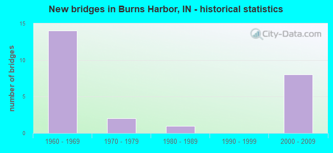
- New bridges - historical statistics
- 141960-1969
- 21970-1979
- 11980-1989
- 82000-2009

- Reconstructed bridges - Historical Statistics
- 31980-1989
- 31990-1999
- 02000-2009
- 12010-2019


- Bridge Condition - Deck
- 18.2%Very good
- 27.3%Good
- 36.4%Satisfactory
- 9.1%Fair
- 9.1%Poor

- Bridge Condition - Superstructure
- 36.4%Very good
- 36.4%Good
- 9.1%Fair
- 18.2%Poor

- Bridge Condition - Substructure
- 18.2%Very good
- 45.5%Good
- 27.3%Satisfactory
- 9.1%Poor

- Bridge Condition - Channel
- 25.0%Good
- 50.0%Satisfactory
- 25.0%Fair
Find on map >> Show street view
Structure Number: 3245, Location: 02.00 N I-94 (Lat: 41.620181, Lng: -87.155269), Route carried "on" structure: State highway 249, Year Built: 2000, Year Reconstructed: 2015, Status: Open, Structure Length: 30.24m (99.21ft), Average Daily Traffic: 4,584 (year 2021), Truck Traffic: 40%, Average Future Daily Traffic: 7,940 (year 2029), Design Load: Greater than HL93, Features Intersected: US 12, 2 RR, 2 ROADS
Minimum Vertical Clearance: 30+ m (98+ ft), Kilometerpoint: 3.605, Lanes on structure: 2, Lanes under structure: 7, Base Highway Network: Yes (, Subroute: 1), Owner: State Highway Agency, Approaching Roadway Width: 10.7m (35.1ft), Skew: 1 degrees, Material/Design: Prestressed concrete continuous, Design/Construction: Tee Beam, Number Of Spans In Main Unit: 10, Length of Maximum Span: 35.0m (114.8ft), Curb-To-Curb Width: 10.8m (35.4ft), Out-to-Out Width: 11.7m (38.4ft)
Condition: Deck: Poor, Superstructure: Poor, Substructure: Good, Operating Rating: 46.8 metric tons, Method Used To Determine Operating Rating: Load and Resistance Factor (LRFR), Inventory Rating: 36.0 metric tons, Method Used To Determine Inventory Rating: Load and Resistance Factor (LRFR), Structural Evaluation: Meets minimum limits, Deck Geometry: Somewhat better than minimum adequacy, Underclear: High priority of corrective action, Approach Roadway Alignment: Equal to present desirable criteria, Designated Inspection Frequency: Every 12 months, Inspection Date: October 2021, Deck Structure Type: Concrete Cast-file-Place, Wearing Surface/Protective System: Wearing Surface: Epoxy Overlay, Deck Protection: Epoxy Coated Reinforcing
Find on map >> Show street view
Structure Number: 325, Location: 00.24 E SR 149 (Lat: 41.620450, Lng: -87.121481), Route carried "on" structure: US 12, Year Built: 1968, Year Reconstructed: 2001, Status: Open, Structure Length: 8.60m (28.22ft), Average Daily Traffic: 8,385 (year 2004), Truck Traffic: 5%, Average Future Daily Traffic: 11,816 (year 2029), Design Load: HS 20, Features Intersected: N&S RR, BETH STEEL RAMP
Minimum Vertical Clearance: 30+ m (98+ ft), Kilometerpoint: 8.530, Lanes on structure: 3, Lanes under structure: 2, Owner: State Highway Agency, Approaching Roadway Width: 15.2m (49.9ft), Skew: 3 degrees, Material/Design: Steel continuous, Design/Construction: Stringer/Multi-beam, Number Of Spans In Main Unit: 4, Length of Maximum Span: 29.1m (95.5ft), Curb-To-Curb Width: 14.0m (45.9ft), Out-to-Out Width: 14.9m (48.9ft)
Condition: Deck: Fair, Superstructure: Good, Substructure: Satisfactory, Operating Rating: 46.0 metric tons, Method Used To Determine Operating Rating: Load and Resistance Factor Rating (LRFR) rating reported by rating factor(RF) method using HL-93 loadings, Inventory Rating: 35.6 metric tons, Method Used To Determine Inventory Rating: Load and Resistance Factor Rating (LRFR) rating reported by rating factor(RF) method using HL-93 loadings, Structural Evaluation: Equal to present minimum criteria, Deck Geometry: Somewhat better than minimum adequacy, Underclear: Meets minimum limits, Approach Roadway Alignment: Equal to present desirable criteria, Designated Inspection Frequency: Every 24 months, Inspection Date: September 2020, Deck Structure Type: Concrete Cast-file-Place, Wearing Surface/Protective System: Wearing Surface: Monolithic Concrete, Deck Protection: Epoxy Coated Reinforcing
Find on map >> Show street view
Structure Number: 326, Location: 00.24 E SR 149 (Lat: 41.620539, Lng: -87.121864), Route carried "on" structure: US 12, Year Built: 1968, Year Reconstructed: 2001, Status: Open, Structure Length: 8.60m (28.22ft), Average Daily Traffic: 8,385 (year 2004), Truck Traffic: 5%, Average Future Daily Traffic: 11,816 (year 2029), Design Load: HS 20, Features Intersected: N&S RR, BETH STEEL RAMP
Minimum Vertical Clearance: 30+ m (98+ ft), Kilometerpoint: 8.530, Lanes on structure: 3, Lanes under structure: 2, Owner: State Highway Agency, Approaching Roadway Width: 15.2m (49.9ft), Skew: 3 degrees, Material/Design: Steel continuous, Design/Construction: Stringer/Multi-beam, Number Of Spans In Main Unit: 4, Length of Maximum Span: 29.1m (95.5ft), Curb-To-Curb Width: 14.0m (45.9ft), Out-to-Out Width: 14.9m (48.9ft)
Condition: Deck: Satisfactory, Superstructure: Good, Substructure: Satisfactory, Operating Rating: 88.0 metric tons, Method Used To Determine Operating Rating: Load Factor (LF), Inventory Rating: 52.6 metric tons, Method Used To Determine Inventory Rating: Load Factor (LF), Structural Evaluation: Equal to present minimum criteria, Deck Geometry: Somewhat better than minimum adequacy, Underclear: Meets minimum limits, Approach Roadway Alignment: Equal to present desirable criteria, Designated Inspection Frequency: Every 24 months, Inspection Date: September 2020, Deck Structure Type: Concrete Cast-file-Place, Wearing Surface/Protective System: Wearing Surface: Monolithic Concrete, Deck Protection: Epoxy Coated Reinforcing
Find on map >> Show street view
Structure Number: 2736, Location: 00.39 N US 20 (Lat: 41.607231, Lng: -87.125450), Route carried "on" structure: State highway 149, Year Built: 1969, Year Reconstructed: 2002, Status: Open, Structure Length: 6.52m (21.39ft), Average Daily Traffic: 10,300 (year 2004), Truck Traffic: 5%, Average Future Daily Traffic: 14,513 (year 2030), Design Load: HS 20, Features Intersected: I-94 EB/WB
Minimum Vertical Clearance: 30+ m (98+ ft), Kilometerpoint: 12.730, Lanes on structure: 4, Lanes under structure: 6, Owner: State Highway Agency, Approaching Roadway Width: 29.3m (96.1ft), Skew: 30 degrees, Material/Design: Steel continuous, Design/Construction: Stringer/Multi-beam, Number Of Spans In Main Unit: 2, Length of Maximum Span: 32.0m (105.0ft), Curb-To-Curb Width: 29.0m (95.1ft), Out-to-Out Width: 30.8m (101.0ft)
Condition: Deck: Very good, Superstructure: Very good, Substructure: Very good, Operating Rating: 46.7 metric tons, Method Used To Determine Operating Rating: Load and Resistance Factor Rating (LRFR) rating reported by rating factor(RF) method using HL-93 loadings, Inventory Rating: 36.0 metric tons, Method Used To Determine Inventory Rating: Load and Resistance Factor Rating (LRFR) rating reported by rating factor(RF) method using HL-93 loadings, Structural Evaluation: Equal to present desirable criteria, Deck Geometry: Superior to present desirable criteria, Underclear: High priority of corrective action, Approach Roadway Alignment: Equal to present desirable criteria, Designated Inspection Frequency: Every 24 months, Inspection Date: November 2021, Deck Structure Type: Concrete Cast-file-Place, Wearing Surface/Protective System: Wearing Surface: Latex Concrete, Deck Protection: Epoxy Coated Reinforcing
Find on map >> Show street view
Structure Number: 2737, Location: 00.14 S US 12 (Lat: 41.616919, Lng: -87.125961), Route carried "on" structure: State highway 149, Year Built: 1970, Year Reconstructed: 2021, Status: Open, Structure Length: 27.49m (90.19ft), Average Daily Traffic: 5,485 (year 2020), Truck Traffic: 9%, Average Future Daily Traffic: 14,513 (year 2030), Design Load: HS 20, Features Intersected: LITTLE CALUMET RIVER
Minimum Vertical Clearance: 30+ m (98+ ft), Kilometerpoint: 13.824, Lanes on structure: 4, Owner: State Highway Agency, Approaching Roadway Width: 23.2m (76.1ft), Skew: 30 degrees, Material/Design: Prestressed concrete continuous, Design/Construction: Stringer/Multi-beam, Number Of Spans In Main Unit: 18, Length of Maximum Span: 15.2m (49.9ft), Curb-To-Curb Width: 25.6m (84.0ft), Out-to-Out Width: 26.5m (86.9ft)
Condition: Deck: Very good, Superstructure: Good, Substructure: Very good, Channel: Good, Operating Rating: 48.6 metric tons, Method Used To Determine Operating Rating: Load and Resistance Factor Rating (LRFR) rating reported by rating factor(RF) method using HL-93 loadings, Inventory Rating: 36.0 metric tons, Method Used To Determine Inventory Rating: Load and Resistance Factor Rating (LRFR) rating reported by rating factor(RF) method using HL-93 loadings, Structural Evaluation: Better than present minimum criteria, Deck Geometry: Superior to present desirable criteria, Waterway Adequacy: Equal to present desirable criteria, Approach Roadway Alignment: Equal to present minimum criteria, Length Of Structure Improvement: 30.48m (100.00ft), Designated Inspection Frequency: Every 24 months, Inspection Date: November 2021, Bridge Improvement Cost: $5,500,000, Total Project Cost: $5,500,000, Deck Structure Type: Concrete Cast-file-Place, Wearing Surface/Protective System: Wearing Surface: Latex Concrete
Find on map >> Show street view
Structure Number: 30466, Location: 00.27 N SR 249 (Lat: 41.619239, Lng: -87.173469), Route carried "on" structure: Ramp State highway 249, Year Built: 2004, Status: Open, Structure Length: 11.31m (37.11ft), Average Daily Traffic: 5,000 (year 2005), Truck Traffic: 20%, Average Future Daily Traffic: 7,800 (year 2030), Design Load: HS 20+Mod, Features Intersected: US 12 EB/WB, 2 RR
Minimum Vertical Clearance: 30+ m (98+ ft), Kilometerpoint: 0.435, Lanes on structure: 2, Lanes under structure: 4, Owner: County Highway Agency, Approaching Roadway Width: 14.6m (47.9ft), Skew: 1 degrees, Material/Design: Steel continuous, Design/Construction: Stringer/Multi-beam, Number Of Spans In Main Unit: 3, Length of Maximum Span: 47.2m (154.9ft), Curb-To-Curb Width: 14.6m (47.9ft), Out-to-Out Width: 15.5m (50.9ft)
Condition: Deck: Satisfactory, Superstructure: Very good, Substructure: Good, Operating Rating: 88.0 metric tons, Method Used To Determine Operating Rating: Load Factor (LF), Inventory Rating: 52.6 metric tons, Method Used To Determine Inventory Rating: Load Factor (LF), Structural Evaluation: Better than present minimum criteria, Deck Geometry: Superior to present desirable criteria, Underclear: Meets minimum limits, Approach Roadway Alignment: Equal to present desirable criteria, Designated Inspection Frequency: Every 24 months, Inspection Date: September 2021, Deck Structure Type: Concrete Cast-file-Place, Wearing Surface/Protective System: Wearing Surface: Monolithic Concrete, Deck Protection: Epoxy Coated Reinforcing
Find on map >> Show street view
Structure Number: 4908, Location: 00.88 E SR 149 (Lat: 41.607081, Lng: -87.107911), Route carried "on" structure: Interstate 94, Year Built: 1969, Year Reconstructed: 1993, Status: Open, Structure Length: 10.94m (35.89ft), Average Daily Traffic: 35,345 (year 2020), Truck Traffic: 20%, Average Future Daily Traffic: 71,320 (year 2030), Design Load: HS 20+Mod, Features Intersected: US 20 EB/WB
Minimum Vertical Clearance: 30+ m (98+ ft), Kilometerpoint: 35.824, Lanes on structure: 4, Lanes under structure: 6, Base Highway Network: Yes (, Subroute: 1), Owner: State Highway Agency, Approaching Roadway Width: 22.9m (75.1ft), Skew: 5 degrees, Material/Design: Steel continuous, Design/Construction: Stringer/Multi-beam, Number Of Spans In Main Unit: 4, Length of Maximum Span: 35.1m (115.2ft), Curb-To-Curb Width: 22.0m (72.2ft), Out-to-Out Width: 22.9m (75.1ft)
Condition: Deck: Good, Superstructure: Very good, Substructure: Good, Operating Rating: 48.6 metric tons, Method Used To Determine Operating Rating: Load and Resistance Factor Rating (LRFR) rating reported by rating factor(RF) method using HL-93 loadings, Inventory Rating: 37.6 metric tons, Method Used To Determine Inventory Rating: Load and Resistance Factor Rating (LRFR) rating reported by rating factor(RF) method using HL-93 loadings, Structural Evaluation: Better than present minimum criteria, Deck Geometry: Better than present minimum criteria, Underclear: Equal to present minimum criteria, Approach Roadway Alignment: Equal to present desirable criteria, Length Of Structure Improvement: 10.94m (35.89ft), Designated Inspection Frequency: Every 24 months, Inspection Date: Febuary 2022, Bridge Improvement Cost: $2,666,000, Roadway Improvement Cost: $200,000, Total Project Cost: $2,866,000 ( Estimate for 2014), Deck Structure Type: Concrete Cast-file-Place, Wearing Surface/Protective System: Wearing Surface: Latex Concrete
Find on map >> Show street view
Structure Number: 4909, Location: 00.88 E SR 149 (Lat: 41.607219, Lng: -87.107939), Route carried "on" structure: Interstate 94, Year Built: 1969, Year Reconstructed: 1993, Status: Open, Structure Length: 10.94m (35.89ft), Average Daily Traffic: 35,803 (year 2004), Truck Traffic: 5%, Average Future Daily Traffic: 71,320 (year 2030), Design Load: HS 20+Mod, Features Intersected: US 20 EB/WB
Minimum Vertical Clearance: 30+ m (98+ ft), Kilometerpoint: 35.824, Lanes on structure: 4, Lanes under structure: 6, Base Highway Network: Yes (, Subroute: 1), Owner: State Highway Agency, Approaching Roadway Width: 22.9m (75.1ft), Skew: 5 degrees, Material/Design: Steel continuous, Design/Construction: Stringer/Multi-beam, Number Of Spans In Main Unit: 4, Length of Maximum Span: 35.1m (115.2ft), Curb-To-Curb Width: 22.0m (72.2ft), Out-to-Out Width: 22.9m (75.1ft)
Condition: Deck: Good, Superstructure: Very good, Substructure: Good, Operating Rating: 48.6 metric tons, Method Used To Determine Operating Rating: Load and Resistance Factor Rating (LRFR) rating reported by rating factor(RF) method using HL-93 loadings, Inventory Rating: 37.6 metric tons, Method Used To Determine Inventory Rating: Load and Resistance Factor Rating (LRFR) rating reported by rating factor(RF) method using HL-93 loadings, Structural Evaluation: Better than present minimum criteria, Deck Geometry: Better than present minimum criteria, Underclear: Equal to present minimum criteria, Approach Roadway Alignment: Equal to present desirable criteria, Length Of Structure Improvement: 10.94m (35.89ft), Designated Inspection Frequency: Every 24 months, Inspection Date: May 2020, Bridge Improvement Cost: $6,554,000, Roadway Improvement Cost: $200,000, Total Project Cost: $6,754,000 ( Estimate for 2014), Deck Structure Type: Concrete Cast-file-Place, Wearing Surface/Protective System: Wearing Surface: Latex Concrete
Find on map >> Show street view
Structure Number: 30001, Location: 00.42 W OF CR 1200 E (Lat: 39.174469, Lng: -85.695008), Route carried "on" structure: County highway 26, Year Built: 1987, Status: Open, Structure Length: 2.04m (6.69ft), Average Daily Traffic: 1,570 (year 2018), Truck Traffic: 3%, Average Future Daily Traffic: 2,730 (year 2038), Design Load: HS 20, Features Intersected: BEAR CREEK, Facility Carried by Structure: CR 200S
Minimum Vertical Clearance: 30+ m (98+ ft), Kilometerpoint: 0.000, Lanes on structure: 2, Owner: County Highway Agency, Approaching Roadway Width: 6.7m (22.0ft), Skew: 2 degrees, Material/Design: Concrete continuous, Design/Construction: Slab, Number Of Spans In Main Unit: 2, Length of Maximum Span: 9.5m (31.2ft), Curb-To-Curb Width: 8.5m (27.9ft), Out-to-Out Width: 9.4m (30.8ft)
Condition: Deck: Good, Superstructure: Good, Substructure: Good, Channel: Satisfactory, Operating Rating: 32.7 metric tons, Method Used To Determine Operating Rating: Field evaluation and documented engineering judgment, Inventory Rating: 32.7 metric tons, Method Used To Determine Inventory Rating: Field evaluation and documented engineering judgment, Structural Evaluation: Better than present minimum criteria, Deck Geometry: Somewhat better than minimum adequacy, Waterway Adequacy: Equal to present desirable criteria, Approach Roadway Alignment: Equal to present minimum criteria, Designated Inspection Frequency: Every 24 months, Inspection Date: May 2020, Deck Structure Type: Concrete Cast-file-Place, Wearing Surface/Protective System: Wearing Surface: Monolithic Concrete
Find on map >> Show street view
Structure Number: 30004, Location: 00.14 E OF CR 800 E (Lat: 39.265300, Lng: -85.759561), Route carried "on" structure: Alternate County highway 50, Year Built: 1965, Year Reconstructed: 1992, Status: Posted for load, Structure Length: 1.25m (4.10ft), Average Daily Traffic: 290 (year 2018), Truck Traffic: 3%, Average Future Daily Traffic: 500 (year 2038), Features Intersected: DUCK CREEK, Facility Carried by Structure: CR 425N
Minimum Vertical Clearance: 30+ m (98+ ft), Kilometerpoint: 0.000, Lanes on structure: 2, Owner: County Highway Agency, Approaching Roadway Width: 5.2m (17.1ft), Material/Design: Steel, Design/Construction: Stringer/Multi-beam, Number Of Spans In Main Unit: 1, Length of Maximum Span: 11.7m (38.4ft), Curb-To-Curb Width: 6.6m (21.7ft), Out-to-Out Width: 6.7m (22.0ft)
Condition: Deck: Satisfactory, Superstructure: Fair, Substructure: Poor, Channel: Satisfactory, Operating Rating: 48.0 metric tons, Method Used To Determine Operating Rating: Load Factor (LF), Inventory Rating: 28.8 metric tons, Method Used To Determine Inventory Rating: Load Factor (LF), Structural Evaluation: Meets minimum limits, Deck Geometry: Meets minimum limits, Waterway Adequacy: Somewhat better than minimum adequacy, Approach Roadway Alignment: Equal to present desirable criteria, Length Of Structure Improvement: 1.25m (4.10ft), Designated Inspection Frequency: Every 12 months, Inspection Date: May 2021, Bridge Improvement Cost: $260,000, Roadway Improvement Cost: $184,000, Total Project Cost: $561,000 ( Estimate for 2020), Deck Structure Type: Concrete Cast-file-Place, Wearing Surface/Protective System: Wearing Surface: Monolithic Concrete
Find on map >> Show street view
Structure Number: 30011, Location: 01.06 W OF US 31 (Lat: 39.129069, Lng: -85.856069), Route carried "on" structure: Alternate County highway 21, Year Built: 1973, Status: Open, Structure Length: 2.71m (8.89ft), Average Daily Traffic: 870 (year 2018), Truck Traffic: 5%, Average Future Daily Traffic: 1,510 (year 2038), Design Load: HS 20, Features Intersected: LITTLE SAND CREEK, Facility Carried by Structure: CR 500S
Minimum Vertical Clearance: 30+ m (98+ ft), Kilometerpoint: 0.000, Lanes on structure: 2, Owner: County Highway Agency, Approaching Roadway Width: 6.1m (20.0ft), Material/Design: Concrete, Design/Construction: Channel Beam, Number Of Spans In Main Unit: 3, Length of Maximum Span: 9.1m (29.9ft), Curb-To-Curb Width: 7.3m (24.0ft), Out-to-Out Width: 7.4m (24.3ft)
Condition: Deck: Satisfactory, Superstructure: Poor, Substructure: Satisfactory, Channel: Fair, Operating Rating: 32.7 metric tons, Method Used To Determine Operating Rating: Field evaluation and documented engineering judgment, Inventory Rating: 32.7 metric tons, Method Used To Determine Inventory Rating: Field evaluation and documented engineering judgment, Structural Evaluation: Meets minimum limits, Deck Geometry: Meets minimum limits, Waterway Adequacy: Equal to present minimum criteria, Approach Roadway Alignment: Equal to present minimum criteria, Length Of Structure Improvement: 2.71m (8.89ft), Designated Inspection Frequency: Every 12 months, Inspection Date: May 2021, Bridge Improvement Cost: $203,000, Roadway Improvement Cost: $184,000, Total Project Cost: $469,000 ( Estimate for 2020), Deck Structure Type: Concrete Precast Panels, Wearing Surface/Protective System: Wearing Surface: Bituminous
Find on map >> Show street view
Structure Number: 3245, Location: 02.00 N I-94 (Lat: 41.620181, Lng: -87.155272), Route carried "under" structure: US 12, Year Built: 2000, Structure Length: 0. m, Average Daily Traffic: 3,610 (year 2004), Truck Traffic: 40%, Features Intersected: US-12 EBL
Minimum Vertical Clearance: 8.82m (28.94ft), Kilometerpoint: 5.729, Lanes on structure: 2, Lanes under structure: 3, Material/Design: Prestressed concrete continuous, Design/Construction: Tee Beam, Length of Maximum Span: 35.0m (114.8ft)
Find on map >> Show street view
Structure Number: 3245, Location: 02.00 N I-94 (Lat: 41.620181, Lng: -87.155272), Route carried "under" structure: US 12, Year Built: 2000, Structure Length: 0. m, Average Daily Traffic: 3,610 (year 2004), Truck Traffic: 40%, Features Intersected: SR 249
Minimum Vertical Clearance: 8.82m (28.94ft), Kilometerpoint: 5.729, Lanes on structure: 2, Lanes under structure: 2, Material/Design: Prestressed concrete continuous, Design/Construction: Tee Beam, Length of Maximum Span: 35.0m (114.8ft)
Find on map >> Show street view
Structure Number: 3245, Location: 02.00 N I-94 (Lat: 41.620181, Lng: -87.155272), Route carried "under" structure: ServiceOther road , Year Built: 2000, Structure Length: 0. m, Average Daily Traffic: 100 (year 2004), Truck Traffic: 20%, Features Intersected: SR 249, Facility Carried by Structure: S BOUNDARY RD
Minimum Vertical Clearance: 8.82m (28.94ft), Kilometerpoint: 5.729, Lanes on structure: 2, Lanes under structure: 2, Material/Design: Prestressed concrete continuous, Design/Construction: Tee Beam, Length of Maximum Span: 35.0m (114.8ft)
Find on map >> Show street view
Structure Number: 3245, Location: 02.00 N I-94 (Lat: 41.620181, Lng: -87.155272), Route carried "under" structure: ServiceOther road , Year Built: 2000, Structure Length: 0. m, Average Daily Traffic: 20 (year 2004), Truck Traffic: 50%, Features Intersected: SR 249, Facility Carried by Structure: RR SERVICE RD
Minimum Vertical Clearance: 8.82m (28.94ft), Kilometerpoint: 5.729, Lanes on structure: 2, Lanes under structure: 2, Material/Design: Prestressed concrete continuous, Design/Construction: Tee Beam, Length of Maximum Span: 35.0m (114.8ft)
Find on map >> Show street view
Structure Number: 325, Location: 00.24 E SR 149 (Lat: 41.620450, Lng: -87.121483), Route carried "under" structure: Ramp Other road , Year Built: 1968, Structure Length: 0. m, Average Daily Traffic: 118 (year 2004), Truck Traffic: 5%, Features Intersected: US 12 EB, Facility Carried by Structure: STEEL MILL RAMP
Minimum Vertical Clearance: 7.26m (23.82ft), Kilometerpoint: 0.000, Lanes on structure: 3, Lanes under structure: 2, Material/Design: Steel continuous, Design/Construction: Stringer/Multi-beam, Length of Maximum Span: 29.1m (95.5ft)
Find on map >> Show street view
Structure Number: 326, Location: 00.24 E SR 149 (Lat: 41.620539, Lng: -87.121864), Route carried "under" structure: Ramp Other road , Year Built: 1968, Structure Length: 0. m, Average Daily Traffic: 118 (year 2004), Truck Traffic: 5%, Features Intersected: US 12 WB, Facility Carried by Structure: STEEL MILL RAMP
Minimum Vertical Clearance: 6.07m (19.91ft), Kilometerpoint: 0.000, Lanes on structure: 3, Lanes under structure: 2, Material/Design: Steel continuous, Design/Construction: Stringer/Multi-beam, Length of Maximum Span: 29.1m (95.5ft)
Find on map >> Show street view
Structure Number: 2736, Location: 00.39 N US-20 (Lat: 41.607231, Lng: -87.125450), Route carried "under" structure: Interstate 94, Year Built: 1969, Structure Length: 0. m, Average Daily Traffic: 35,810 (year 2004), Truck Traffic: 20%, Features Intersected: I-94 EBL, Facility Carried by Structure: SR 149
Minimum Vertical Clearance: 4.93m (16.17ft), Kilometerpoint: 34.408, Lanes on structure: 4, Lanes under structure: 6, Material/Design: Steel continuous, Design/Construction: Stringer/Multi-beam, Length of Maximum Span: 32.0m (105.0ft)
Find on map >> Show street view
Structure Number: 2736, Location: 00.39 N US-20 (Lat: 41.607231, Lng: -87.125450), Route carried "under" structure: Interstate 94, Year Built: 1969, Structure Length: 0. m, Average Daily Traffic: 35,810 (year 2004), Truck Traffic: 20%, Features Intersected: I-94 WBL, Facility Carried by Structure: SR 149
Minimum Vertical Clearance: 4.93m (16.17ft), Kilometerpoint: 34.408, Lanes on structure: 4, Lanes under structure: 6, Material/Design: Steel continuous, Design/Construction: Stringer/Multi-beam, Length of Maximum Span: 32.0m (105.0ft)
Find on map >> Show street view
Structure Number: 30466, Location: 00.27 N SR 249 (Lat: 41.619239, Lng: -87.173478), Route carried "under" structure: US 12, Year Built: 2004, Structure Length: 0. m, Average Daily Traffic: 3,650 (year 2004), Truck Traffic: 10%, Features Intersected: US-12 WBL, Facility Carried by Structure: SR 249C
Minimum Vertical Clearance: 6.45m (21.16ft), Kilometerpoint: 4.329, Lanes on structure: 2, Lanes under structure: 4, Material/Design: Steel continuous, Design/Construction: Stringer/Multi-beam, Length of Maximum Span: 47.2m (154.9ft)
Find on map >> Show street view
Structure Number: 30466, Location: 00.27 N SR 249 (Lat: 41.619239, Lng: -87.173478), Route carried "under" structure: US 12, Year Built: 2004, Structure Length: 0. m, Average Daily Traffic: 3,650 (year 2005), Truck Traffic: 10%, Features Intersected: US-12 EBL, Facility Carried by Structure: SR 249C
Minimum Vertical Clearance: 6.45m (21.16ft), Kilometerpoint: 4.329, Lanes on structure: 2, Lanes under structure: 4, Material/Design: Steel continuous, Design/Construction: Stringer/Multi-beam, Length of Maximum Span: 47.2m (154.9ft)
Find on map >> Show street view
Structure Number: 4908, Location: 00.88 E SR 149 (Lat: 41.607081, Lng: -87.107911), Route carried "under" structure: US 20, Year Built: 1969, Structure Length: 0. m, Average Daily Traffic: 11,248 (year 2006), Truck Traffic: 10%, Features Intersected: US 20 EBL, Facility Carried by Structure: I-94 EB
Minimum Vertical Clearance: 4.50m (14.76ft), Kilometerpoint: 10.042, Lanes on structure: 4, Lanes under structure: 6, Material/Design: Steel continuous, Design/Construction: Stringer/Multi-beam, Length of Maximum Span: 35.1m (115.2ft)
Find on map >> Show street view
Structure Number: 4908, Location: 00.88 E SR 149 (Lat: 41.607081, Lng: -87.107911), Route carried "under" structure: US 20, Year Built: 1969, Structure Length: 0. m, Average Daily Traffic: 11,248 (year 2006), Truck Traffic: 10%, Features Intersected: US 20 WBL, Facility Carried by Structure: I-94 EB
Minimum Vertical Clearance: 4.50m (14.76ft), Kilometerpoint: 10.042, Lanes on structure: 4, Lanes under structure: 6, Material/Design: Steel continuous, Design/Construction: Stringer/Multi-beam, Length of Maximum Span: 35.1m (115.2ft)
Find on map >> Show street view
Structure Number: 4909, Location: 00.88 E SR 149 (Lat: 41.607269, Lng: -87.107583), Route carried "under" structure: US 20, Year Built: 1969, Structure Length: 0. m, Average Daily Traffic: 11,248 (year 2006), Truck Traffic: 10%, Features Intersected: US 20 EBL, Facility Carried by Structure: I-94 WB
Minimum Vertical Clearance: 4.50m (14.76ft), Kilometerpoint: 10.058, Lanes on structure: 4, Lanes under structure: 6, Material/Design: Steel continuous, Design/Construction: Stringer/Multi-beam, Length of Maximum Span: 35.1m (115.2ft)
Find on map >> Show street view
Structure Number: 4909, Location: 00.88 E SR 149 (Lat: 41.607269, Lng: -87.107583), Route carried "under" structure: US 20, Year Built: 1969, Structure Length: 0. m, Average Daily Traffic: 11,248 (year 2006), Truck Traffic: 10%, Features Intersected: US 20 WBL, Facility Carried by Structure: I-94 WB
Minimum Vertical Clearance: 4.50m (14.76ft), Kilometerpoint: 10.058, Lanes on structure: 4, Lanes under structure: 6, Material/Design: Steel continuous, Design/Construction: Stringer/Multi-beam, Length of Maximum Span: 35.1m (115.2ft)