Bridge Statistics for Cambridge, Massachusetts (MA)
Condition, Traffic, Stress, Structural Evaluation, Project Costs
- National Bridge Inventory (NBI) Statistics
- 18Number of bridges
- 407ft / 124mTotal length
- $128,892,000Total costs
- 490,797Total average daily traffic
- 15,792Total average daily truck traffic
- 914,888Total future (year 2031) average daily traffic
- National Bridge Inventory (NBI) Registered Bridges for Cambridge
- No street view available for this location
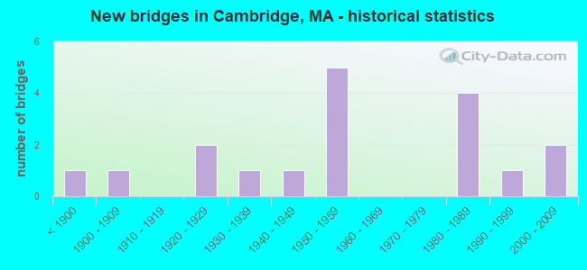
- New bridges - historical statistics
- 1Before 1900
- 11900-1909
- 21920-1929
- 11930-1939
- 11940-1949
- 51950-1959
- 41980-1989
- 11990-1999
- 22000-2009

- Reconstructed bridges - Historical Statistics
- 21970-1979
- 11980-1989
- 21990-1999
- 12000-2009


- Bridge Condition - Deck
- 29.4%Good
- 23.5%Satisfactory
- 29.4%Fair
- 11.8%Poor
- 5.9%Serious

- Bridge Condition - Superstructure
- 44.4%Good
- 11.1%Satisfactory
- 27.8%Fair
- 11.1%Poor
- 5.6%Serious

- Bridge Condition - Substructure
- 27.8%Good
- 33.3%Satisfactory
- 33.3%Fair
- 5.6%Poor

- Bridge Condition - Channel
- 40.0%Good
- 40.0%Satisfactory
- 20.0%Fair
Find on map >> Show street view
Structure Number: C010013F1DOTNBI, Location: 500 FT W OF JCT SR 28 (Lat: 42.368453, Lng: -71.074042), Route carried "on" structure: State highway 3, Year Built: 1986, Status: Open, Structure Length: 3.99m (13.09ft), Average Daily Traffic: 53,793 (year 2018), Truck Traffic: 4%, Average Future Daily Traffic: 63,646 (year 2031), Design Load: HS 20, Features Intersected: WATER LECHMERE CANAL, Facility Carried by Structure: HWY LAND BLVD
Minimum Vertical Clearance: 30+ m (98+ ft), Kilometerpoint: 0.000, Lanes on structure: 6, Base Highway Network: Yes, Owner: State Highway Agency, Approaching Roadway Width: 13.7m (44.9ft), Skew: 10 degrees, Navigation Control: Yes ( Vertical Clearance: 2.1m (6.9ft), Horizontal Clearance: 12.2m (40.0ft)), Material/Design: Steel continuous, Design/Construction: Stringer/Multi-beam, Number Of Spans In Main Unit: 3, Length of Maximum Span: 13.4m (44.0ft), Curb or Sidewalk Widths: Left: 3.7m (12.1ft), Right: 3.7m (12.1ft), Curb-To-Curb Width: 13.7m (44.9ft), Out-to-Out Width: 18.5m (60.7ft)
Condition: Deck: Fair, Superstructure: Good, Substructure: Good, Channel: Satisfactory, Operating Rating: 60.3 metric tons, Method Used To Determine Operating Rating: Allowable Stress (AS), Inventory Rating: 38.4 metric tons, Method Used To Determine Inventory Rating: Allowable Stress (AS), Structural Evaluation: Better than present minimum criteria, Deck Geometry: High priority of replacement, Waterway Adequacy: Superior to present desirable criteria, Approach Roadway Alignment: Better than present minimum criteria, Length Of Structure Improvement: 4.00m (13.12ft), Designated Inspection Frequency: Every 24 months, Underwater Inspection Frequency: Every 36 months, Inspection Date: March 2020, Underwater Inspection Date: June 2020, Bridge Improvement Cost: $8,284,000, Roadway Improvement Cost: $829,000, Total Project Cost: $12,427,000 ( Estimate for 2022), Deck Structure Type: Concrete Cast-file-Place, Wearing Surface/Protective System: Wearing Surface: Bituminous, Membrane: Preformed Fabric, Deck Protection: Epoxy Coated Reinforcing
Find on map >> Show street view
Structure Number: C010084DMDOTNBI, Location: .16 KM N OF LONGFELLOW BR (Lat: 42.362503, Lng: -71.078850), Route carried "on" structure: State highway 3, Year Built: 1924, Year Reconstructed: 2000, Status: Posted for load, Structure Length: 3.66m (12.01ft), Average Daily Traffic: 17,600 (year 2018), Truck Traffic: 4%, Average Future Daily Traffic: 30,007 (year 2031), Design Load: H 20, Features Intersected: WATER BROAD CANAL, Facility Carried by Structure: HWY FIRST ST
Minimum Vertical Clearance: 4.88m (16.01ft), Kilometerpoint: 1.062, Lanes on structure: 2, Base Highway Network: Yes, Owner: State Highway Agency, Approaching Roadway Width: 10.1m (33.1ft), Navigation Control: Yes ( Vertical Clearance: 1.2m (3.9ft), Horizontal Clearance: 12.2m (40.0ft)), Material/Design: Steel, Design/Construction: Girder and Floorbeam System, Number Of Spans In Main Unit: 1, Number Of Approach Spans: 2, Length of Maximum Span: 12.2m (40.0ft), Curb or Sidewalk Widths: Left: 2.1m (6.9ft), Right: 2.1m (6.9ft), Curb-To-Curb Width: 10.1m (33.1ft), Out-to-Out Width: 16.9m (55.4ft)
Condition: Deck: Fair, Superstructure: Fair, Substructure: Poor, Channel: Satisfactory, Operating Rating: 14.6 metric tons, Method Used To Determine Operating Rating: Load Factor (LF), Inventory Rating: 12.9 metric tons, Method Used To Determine Inventory Rating: Load Factor (LF), Structural Evaluation: High priority of replacement, Deck Geometry: Somewhat better than minimum adequacy, Waterway Adequacy: Somewhat better than minimum adequacy, Approach Roadway Alignment: Somewhat better than minimum adequacy, Bridge Posting: Required (Relationship of Operating Rating to Maximum Legal Load: > 39.9% below), Length Of Structure Improvement: 4.60m (15.09ft), Designated Inspection Frequency: Every 12 months, Critical Feature Inspection Frequency: Every 24 months, Underwater Inspection Frequency: Every 12 months, Other Special Inspection Frequency: Every 12 months, Inspection Date: June 2020, Critical Feature Inspection Date: June 2020, Underwater Inspection Date: October 2021, Other Special Inspection Date: June 2021, Bridge Improvement Cost: $4,723,000, Roadway Improvement Cost: $473,000, Total Project Cost: $7,085,000 ( Estimate for 2022), Deck Structure Type: Open Grating, Wearing Surface/Protective System: Wearing Surface: Other
Find on map >> Show street view
Structure Number: C010114DJDOTNBI, Location: .32 KM E OF MAGAZINE ST (Lat: 42.353556, Lng: -71.109000), Route carried "on" structure: State highway 3, Year Built: 1906, Year Reconstructed: 1982, Status: Temporarily open, Structure Length: 1.40m (4.59ft), Average Daily Traffic: 47,200 (year 2019), Truck Traffic: 1%, Average Future Daily Traffic: 78,175 (year 2032), Features Intersected: RR CSX
Minimum Vertical Clearance: 30+ m (98+ ft), Kilometerpoint: 0.016, Lanes on structure: 6, Base Highway Network: Yes, Owner: State Highway Agency, Approaching Roadway Width: 27.7m (90.9ft), Material/Design: Steel, Design/Construction: Stringer/Multi-beam, Number Of Spans In Main Unit: 1, Length of Maximum Span: 13.4m (44.0ft), Curb or Sidewalk Widths: Left: 1.7m (5.6ft), Right: 1.7m (5.6ft), Curb-To-Curb Width: 27.7m (90.9ft), Out-to-Out Width: 31.4m (103.0ft)
Condition: Deck: Satisfactory, Superstructure: Fair, Substructure: Satisfactory, Operating Rating: 50.8 metric tons, Method Used To Determine Operating Rating: Load Factor (LF), Inventory Rating: 13.3 metric tons, Method Used To Determine Inventory Rating: Load Factor (LF), Structural Evaluation: High priority of corrective action, Deck Geometry: Equal to present desirable criteria, Underclear: High priority of corrective action, Approach Roadway Alignment: Equal to present minimum criteria, Length Of Structure Improvement: 1.50m (4.92ft), Designated Inspection Frequency: Every 24 months, Inspection Date: August 2021, Bridge Improvement Cost: $1,851,000, Roadway Improvement Cost: $186,000, Total Project Cost: $2,777,000 ( Estimate for 2022), Deck Structure Type: Concrete Cast-file-Place, Wearing Surface/Protective System: Wearing Surface: Bituminous
Find on map >> Show street view
Structure Number: C010123FUDOT634, Location: .8 KM SE OF JCT SR2A&16 (Lat: 42.388381, Lng: -71.119492), Route carried "on" structure: Alternate State highway 2A, Year Built: 1899, Year Reconstructed: 1986, Status: Open, Structure Length: 1.14m (3.74ft), Average Daily Traffic: 13,500 (year 2018), Truck Traffic: 7%, Average Future Daily Traffic: 47,853 (year 2031), Design Load: HS 20, Features Intersected: RR MBTA/BMRR, Facility Carried by Structure: ST 2 A/MASS AVE
Minimum Vertical Clearance: 30+ m (98+ ft), Kilometerpoint: 0.000, Lanes on structure: 4, Base Highway Network: Yes, Owner: State Highway Agency, Approaching Roadway Width: 19.5m (64.0ft), Skew: 23 degrees, Material/Design: Steel, Design/Construction: Stringer/Multi-beam, Number Of Spans In Main Unit: 2, Length of Maximum Span: 9.9m (32.5ft), Curb or Sidewalk Widths: Left: 3.3m (10.8ft), Right: 3.7m (12.1ft), Curb-To-Curb Width: 19.5m (64.0ft), Out-to-Out Width: 28.7m (94.2ft)
Condition: Deck: Satisfactory, Superstructure: Good, Substructure: Satisfactory, Operating Rating: 47.6 metric tons, Method Used To Determine Operating Rating: Allowable Stress (AS), Inventory Rating: 32.0 metric tons, Method Used To Determine Inventory Rating: Allowable Stress (AS), Structural Evaluation: Equal to present minimum criteria, Deck Geometry: Better than present minimum criteria, Underclear: High priority of corrective action, Approach Roadway Alignment: Equal to present desirable criteria, Length Of Structure Improvement: 1.20m (3.94ft), Designated Inspection Frequency: Every 24 months, Inspection Date: March 2020, Bridge Improvement Cost: $1,353,000, Roadway Improvement Cost: $136,000, Total Project Cost: $2,030,000 ( Estimate for 2022), Deck Structure Type: Concrete Cast-file-Place, Wearing Surface/Protective System: Wearing Surface: Bituminous, Membrane: Built-up
Find on map >> Show street view
Structure Number: C01013ATEDOT634, Location: 2.1 KM S OF JCT SR2A&16 (Lat: 42.389331, Lng: -71.124758), Route carried "on" structure: City street , Year Built: 2009, Status: Open, Structure Length: 2.86m (9.38ft), Average Daily Traffic: 9,500 (year 2019), Truck Traffic: 1%, Average Future Daily Traffic: 11,371 (year 2032), Design Load: HS 20, Features Intersected: RR MBTA/BMRR, Facility Carried by Structure: HWY WALDEN ST
Minimum Vertical Clearance: 30+ m (98+ ft), Kilometerpoint: 0.241, Lanes on structure: 2, Owner: State Highway Agency, Approaching Roadway Width: 8.5m (27.9ft), Skew: 1 degrees, Material/Design: Prestressed concrete, Design/Construction: Slab, Number Of Spans In Main Unit: 2, Length of Maximum Span: 14.1m (46.3ft), Curb or Sidewalk Widths: Left: 1.9m (6.2ft), Right: 1.9m (6.2ft), Curb-To-Curb Width: 8.5m (27.9ft), Out-to-Out Width: 13.1m (43.0ft)
Condition: Deck: Good, Superstructure: Good, Substructure: Good, Operating Rating: 68.7 metric tons, Method Used To Determine Operating Rating: Load Factor (LF), Inventory Rating: 41.1 metric tons, Method Used To Determine Inventory Rating: Load Factor (LF), Structural Evaluation: Better than present minimum criteria, Deck Geometry: High priority of replacement, Underclear: High priority of corrective action, Approach Roadway Alignment: Equal to present minimum criteria, Length Of Structure Improvement: 2.90m (9.51ft), Designated Inspection Frequency: Every 24 months, Inspection Date: March 2021, Bridge Improvement Cost: $1,340,000, Roadway Improvement Cost: $135,000, Total Project Cost: $2,011,000 ( Estimate for 2022), Deck Structure Type: Concrete Cast-file-Place, Wearing Surface/Protective System: Wearing Surface: Integral Concrete, Deck Protection: Epoxy Coated Reinforcing
Find on map >> Show street view
Structure Number: C010143FVDOT634, Location: 2 MI S OF JCT SR2 (Lat: 42.374597, Lng: -71.150067), Route carried "on" structure: State highway , Year Built: 1955, Status: Open, Structure Length: 1.31m (4.30ft), Average Daily Traffic: 19,000 (year 2018), Truck Traffic: 8%, Average Future Daily Traffic: 60,803 (year 2031), Design Load: H 20, Features Intersected: OTHER GREENWAY M/U PATH, Facility Carried by Structure: HWY MT AUBURN ST
Minimum Vertical Clearance: 30+ m (98+ ft), Kilometerpoint: 0.000, Lanes on structure: 5, Base Highway Network: Yes, Owner: State Highway Agency, Approaching Roadway Width: 16.8m (55.1ft), Skew: 24 degrees, Material/Design: Steel, Design/Construction: Stringer/Multi-beam, Number Of Spans In Main Unit: 1, Length of Maximum Span: 10.4m (34.1ft), Curb or Sidewalk Widths: Left: 3.1m (10.2ft), Right: 3.3m (10.8ft), Curb-To-Curb Width: 40.8m (133.9ft), Out-to-Out Width: 48.5m (159.1ft)
Condition: Deck: Fair, Superstructure: Fair, Substructure: Fair, Operating Rating: 31.0 metric tons, Method Used To Determine Operating Rating: Load Factor (LF), Inventory Rating: 28.5 metric tons, Method Used To Determine Inventory Rating: Load Factor (LF), Structural Evaluation: Somewhat better than minimum adequacy, Deck Geometry: Superior to present desirable criteria, Underclear: High priority of corrective action, Approach Roadway Alignment: Better than present minimum criteria, Bridge Posting: Required (Relationship of Operating Rating to Maximum Legal Load: 0.1 - 9.9% below), Length Of Structure Improvement: 1.40m (4.59ft), Designated Inspection Frequency: Every 24 months, Inspection Date: September 2020, Bridge Improvement Cost: $2,668,000, Roadway Improvement Cost: $267,000, Total Project Cost: $4,003,000 ( Estimate for 2022), Deck Structure Type: Concrete Cast-file-Place, Wearing Surface/Protective System: Wearing Surface: Bituminous, Membrane: Preformed Fabric, Deck Protection: Epoxy Coated Reinforcing
Find on map >> Show street view
Structure Number: C010153FRDOT634, Location: 2.4 KM S OF JCT SR2 (Lat: 42.378903, Lng: -71.147764), Route carried "on" structure: City street , Year Built: 1985, Status: Open, Structure Length: 1.62m (5.31ft), Average Daily Traffic: 10,300 (year 2018), Truck Traffic: 1%, Average Future Daily Traffic: 18,636 (year 2031), Design Load: H 20, Features Intersected: OTHER GREENWAY M/U PATH, Facility Carried by Structure: HWY HURON AVE
Minimum Vertical Clearance: 30+ m (98+ ft), Kilometerpoint: 0.000, Lanes on structure: 3, Owner: State Highway Agency, Approaching Roadway Width: 15.8m (51.8ft), Skew: 21 degrees, Material/Design: Steel, Design/Construction: Stringer/Multi-beam, Number Of Spans In Main Unit: 1, Length of Maximum Span: 13.4m (44.0ft), Curb or Sidewalk Widths: Left: 1.5m (4.9ft), Right: 1.5m (4.9ft), Curb-To-Curb Width: 15.8m (51.8ft), Out-to-Out Width: 19.8m (65.0ft)
Condition: Deck: Satisfactory, Superstructure: Satisfactory, Substructure: Good, Operating Rating: 75.6 metric tons, Method Used To Determine Operating Rating: Load Factor (LF), Inventory Rating: 45.3 metric tons, Method Used To Determine Inventory Rating: Load Factor (LF), Structural Evaluation: Equal to present minimum criteria, Deck Geometry: Better than present minimum criteria, Underclear: Meets minimum limits, Approach Roadway Alignment: Better than present minimum criteria, Length Of Structure Improvement: 1.70m (5.58ft), Designated Inspection Frequency: Every 24 months, Inspection Date: September 2020, Bridge Improvement Cost: $417,000, Roadway Improvement Cost: $42,000, Total Project Cost: $626,000 ( Estimate for 2022), Deck Structure Type: Concrete Cast-file-Place, Wearing Surface/Protective System: Wearing Surface: Bituminous, Membrane: Built-up, Deck Protection: Epoxy Coated Reinforcing
Find on map >> Show street view
Structure Number: C010163FTDOT634, Location: 150 M JCT SR 16&2 (Lat: 42.380833, Lng: -71.144639), Route carried "on" structure: City street , Year Built: 1927, Year Reconstructed: 1997, Status: Open, Structure Length: 1.24m (4.07ft), Average Daily Traffic: 775 (year 2019), Truck Traffic: 1%, Average Future Daily Traffic: 2,527 (year 2032), Design Load: HS 20, Features Intersected: OTHER GREENWAY M/U PATH, Facility Carried by Structure: HWY FRESH PND LN
Minimum Vertical Clearance: 30+ m (98+ ft), Kilometerpoint: 0.016, Lanes on structure: 2, Owner: State Highway Agency, Approaching Roadway Width: 6.7m (22.0ft), Skew: 2 degrees, Material/Design: Prestressed concrete, Design/Construction: Slab, Number Of Spans In Main Unit: 1, Length of Maximum Span: 11.1m (36.4ft), Curb or Sidewalk Widths: Left: 1.8m (5.9ft), Right: 0.0m, Curb-To-Curb Width: 6.7m (22.0ft), Out-to-Out Width: 9.4m (30.8ft)
Condition: Deck: Good, Superstructure: Good, Substructure: Satisfactory, Operating Rating: 68.4 metric tons, Method Used To Determine Operating Rating: Allowable Stress (AS), Inventory Rating: 41.0 metric tons, Method Used To Determine Inventory Rating: Allowable Stress (AS), Structural Evaluation: Equal to present minimum criteria, Deck Geometry: High priority of replacement, Underclear: High priority of corrective action, Approach Roadway Alignment: Equal to present minimum criteria, Length Of Structure Improvement: 1.30m (4.27ft), Designated Inspection Frequency: Every 24 months, Inspection Date: September 2021, Bridge Improvement Cost: $748,000, Roadway Improvement Cost: $75,000, Total Project Cost: $1,123,000 ( Estimate for 2022), Deck Structure Type: Concrete Precast Panels, Wearing Surface/Protective System: Wearing Surface: Bituminous, Membrane: Built-up, Deck Protection: Epoxy Coated Reinforcing
Find on map >> Show street view
Structure Number: C010204DHDOTNBI, Location: .1 MI S OF RINGE AVE (Lat: 42.392131, Lng: -71.141114), Route carried "on" structure: US 3, Year Built: 1996, Status: Open, Structure Length: 10.55m (34.61ft), Average Daily Traffic: 72,000 (year 2019), Truck Traffic: 3%, Average Future Daily Traffic: 107,392 (year 2032), Design Load: HS 20, Features Intersected: RR MBTA/BMRR
Minimum Vertical Clearance: 0.00m, Kilometerpoint: 80.516, Lanes on structure: 4, Base Highway Network: Yes, Owner: State Highway Agency, Approaching Roadway Width: 25.3m (83.0ft), Skew: 20 degrees, Material/Design: Steel continuous, Design/Construction: Stringer/Multi-beam, Number Of Spans In Main Unit: 3, Length of Maximum Span: 36.6m (120.1ft), Curb or Sidewalk Widths: Left: 3.1m (10.2ft), Right: 2.0m (6.6ft), Curb-To-Curb Width: 17.7m (58.1ft), Out-to-Out Width: 25.3m (83.0ft)
Condition: Deck: Good, Superstructure: Good, Substructure: Good, Operating Rating: 69.9 metric tons, Method Used To Determine Operating Rating: Load Factor (LF), Inventory Rating: 41.8 metric tons, Method Used To Determine Inventory Rating: Load Factor (LF), Structural Evaluation: Better than present minimum criteria, Deck Geometry: Somewhat better than minimum adequacy, Underclear: Somewhat better than minimum adequacy, Approach Roadway Alignment: Equal to present desirable criteria, Length Of Structure Improvement: 10.60m (34.78ft), Designated Inspection Frequency: Every 24 months, Inspection Date: Febuary 2021, Bridge Improvement Cost: $4,398,000, Roadway Improvement Cost: $440,000, Total Project Cost: $6,598,000 ( Estimate for 2022), Deck Structure Type: Concrete Cast-file-Place, Wearing Surface/Protective System: Wearing Surface: Bituminous, Membrane: Epoxy, Deck Protection: Epoxy Coated Reinforcing
Find on map >> Show street view
Structure Number: C010214DGDOTNBI, Location: .32 KM N OF RINGE AVE (Lat: 42.396967, Lng: -71.141100), Route carried "on" structure: US 3, Year Built: 1984, Status: Open, Structure Length: 0.91m (2.99ft), Average Daily Traffic: 56,300 (year 2019), Truck Traffic: 4%, Average Future Daily Traffic: 114,499 (year 2032), Design Load: H 20, Features Intersected: HWY ALW STA ACCESS RD
Minimum Vertical Clearance: 30+ m (98+ ft), Kilometerpoint: 80.000, Lanes on structure: 4, Lanes under structure: 1, Base Highway Network: Yes, Owner: State Highway Agency, Approaching Roadway Width: 14.6m (47.9ft), Material/Design: Prestressed concrete, Design/Construction: Arch - Deck, Number Of Spans In Main Unit: 1, Length of Maximum Span: 9.1m (29.9ft), Curb or Sidewalk Widths: Left: 3.0m (9.8ft), Right: 0.0m, Curb-To-Curb Width: 14.6m (47.9ft), Out-to-Out Width: 24.4m (80.1ft)
Condition: Superstructure: Satisfactory, Substructure: Satisfactory, Operating Rating: 35.5 metric tons, Method Used To Determine Operating Rating: Load Factor (LF), Inventory Rating: 21.2 metric tons, Method Used To Determine Inventory Rating: Load Factor (LF), Structural Evaluation: Somewhat better than minimum adequacy, Deck Geometry: High priority of replacement, Underclear: High priority of corrective action, Approach Roadway Alignment: Equal to present desirable criteria, Length Of Structure Improvement: 1.00m (3.28ft), Designated Inspection Frequency: Every 24 months, Inspection Date: January 2021, Bridge Improvement Cost: $959,000, Roadway Improvement Cost: $96,000, Total Project Cost: $1,439,000 ( Estimate for 2022)
Find on map >> Show street view
Structure Number: C010234DQDOTNBI, Location: N END HARVARD BR (Lat: 42.357228, Lng: -71.092653), Route carried "on" structure: Alternate State highway 2A, Year Built: 1931, Year Reconstructed: 2003, Status: Open, Structure Length: 1.65m (5.41ft), Average Daily Traffic: 22,500 (year 2019), Truck Traffic: 10%, Average Future Daily Traffic: 39,482 (year 2032), Features Intersected: ST 3 MEMORIAL DR, Facility Carried by Structure: ST 2 A/MASS AVE
Minimum Vertical Clearance: 30+ m (98+ ft), Kilometerpoint: 0.016, Lanes on structure: 5, Lanes under structure: 4, Base Highway Network: Yes, Owner: State Highway Agency, Approaching Roadway Width: 25.0m (82.0ft), Skew: 20 degrees, Material/Design: Steel, Design/Construction: Stringer/Multi-beam, Number Of Spans In Main Unit: 1, Length of Maximum Span: 15.4m (50.5ft), Curb or Sidewalk Widths: Left: 3.5m (11.5ft), Right: 3.5m (11.5ft), Curb-To-Curb Width: 24.7m (81.0ft), Out-to-Out Width: 33.2m (108.9ft)
Condition: Deck: Good, Superstructure: Good, Substructure: Good, Operating Rating: 99.6 metric tons, Method Used To Determine Operating Rating: Load Factor (LF), Inventory Rating: 59.7 metric tons, Method Used To Determine Inventory Rating: Load Factor (LF), Structural Evaluation: Better than present minimum criteria, Deck Geometry: Superior to present desirable criteria, Underclear: High priority of corrective action, Approach Roadway Alignment: Meets minimum limits, Length Of Structure Improvement: 1.70m (5.58ft), Designated Inspection Frequency: Every 24 months, Inspection Date: June 2021, Bridge Improvement Cost: $177,000, Roadway Improvement Cost: $18,000, Total Project Cost: $266,000 ( Estimate for 2022), Deck Structure Type: Concrete Cast-file-Place, Wearing Surface/Protective System: Wearing Surface: Bituminous, Membrane: Built-up, Deck Protection: Epoxy Coated Reinforcing
Find on map >> Show street view
Structure Number: C010264DFDOTNBI, Location: .2 MI FROM CITY LINE (Lat: 42.354031, Lng: -71.110294), Route carried "on" structure: US 3, Year Built: 1940, Year Reconstructed: 1982, Status: Temporarily open, Structure Length: 18.29m (60.01ft), Average Daily Traffic: 29,000 (year 2014), Average Future Daily Traffic: 47,379 (year 2031), Design Load: H 20, Features Intersected: HWY BROOKLINE ST
Minimum Vertical Clearance: 30+ m (98+ ft), Kilometerpoint: 0.016, Lanes on structure: 4, Lanes under structure: 4, Base Highway Network: Yes, Owner: State Highway Agency, Approaching Roadway Width: 14.3m (46.9ft), Skew: 20 degrees, Material/Design: Steel, Design/Construction: Girder and Floorbeam System, Number Of Spans In Main Unit: 6, Length of Maximum Span: 30.5m (100.1ft), Curb or Sidewalk Widths: Left: 0.2m (0.7ft), Right: 0.2m (0.7ft), Curb-To-Curb Width: 14.3m (46.9ft), Out-to-Out Width: 16.5m (54.1ft)
Condition: Deck: Fair, Superstructure: Poor, Substructure: Fair, Operating Rating: 33.0 metric tons, Method Used To Determine Operating Rating: Load Factor (LF), Inventory Rating: 19.8 metric tons, Method Used To Determine Inventory Rating: Load Factor (LF), Structural Evaluation: Meets minimum limits, Deck Geometry: High priority of replacement, Underclear: High priority of replacement, Approach Roadway Alignment: Better than present minimum criteria, Length Of Structure Improvement: 19.00m (62.34ft), Designated Inspection Frequency: Every 12 months, Critical Feature Inspection Frequency: Every 24 months, Other Special Inspection Frequency: Every 12 months, Inspection Date: July 2020, Critical Feature Inspection Date: July 2020, Other Special Inspection Date: July 2021, Bridge Improvement Cost: $24,184,000, Roadway Improvement Cost: $2,419,000, Total Project Cost: $36,277,000 ( Estimate for 2022), Deck Structure Type: Closed Grating, Wearing Surface/Protective System: Wearing Surface: Monolithic Concrete
Find on map >> Show street view
Structure Number: C010314DRDOTNBI, Location: .4 MI N OF CONCORD AVE (Lat: 42.396217, Lng: -71.140722), Route carried "on" structure: US 3, Year Built: 1983, Status: Posted for load, Structure Length: 2.26m (7.41ft), Average Daily Traffic: 57,550 (year 2019), Truck Traffic: 3%, Average Future Daily Traffic: 114,499 (year 2032), Design Load: HS 20+Mod, Features Intersected: TR RED LINE
Minimum Vertical Clearance: 30+ m (98+ ft), Kilometerpoint: 80.151, Lanes on structure: 4, Base Highway Network: Yes, Owner: State Highway Agency, Approaching Roadway Width: 14.6m (47.9ft), Material/Design: Prestressed concrete, Design/Construction: Box Beam or Girders - Multiple, Number Of Spans In Main Unit: 1, Length of Maximum Span: 19.8m (65.0ft), Curb or Sidewalk Widths: Left: 3.4m (11.2ft), Right: 0.6m (2.0ft), Curb-To-Curb Width: 14.6m (47.9ft), Out-to-Out Width: 19.2m (63.0ft)
Condition: Deck: Serious, Superstructure: Serious, Substructure: Fair, Operating Rating: 34.9 metric tons, Method Used To Determine Operating Rating: Load Factor (LF), Inventory Rating: 20.9 metric tons, Method Used To Determine Inventory Rating: Load Factor (LF), Structural Evaluation: High priority of corrective action, Deck Geometry: High priority of replacement, Approach Roadway Alignment: Equal to present desirable criteria, Length Of Structure Improvement: 3.10m (10.17ft), Designated Inspection Frequency: Every 6 months, Other Special Inspection Frequency: Every 6 months, Inspection Date: Febuary 2021, Other Special Inspection Date: August 2021, Bridge Improvement Cost: $4,336,000, Roadway Improvement Cost: $434,000, Total Project Cost: $6,505,000 ( Estimate for 2022), Deck Structure Type: Concrete Precast Panels, Wearing Surface/Protective System: Wearing Surface: Bituminous
Find on map >> Show street view
Structure Number: C010384DPDOTNBI, Location: JUST S OF LONGFELLOW BR (Lat: 42.360733, Lng: -71.079625), Route carried "on" structure: US 3, Year Built: 1956, Status: Posted for load-capacity, Structure Length: 26.76m (87.80ft), Average Daily Traffic: 13,000 (year 2014), Average Future Daily Traffic: 34,745 (year 2031), Design Load: HS 20, Features Intersected: WATER CHARLES RIVER, Facility Carried by Structure: HWY MEMORL DR EB
Minimum Vertical Clearance: 30+ m (98+ ft), Kilometerpoint: 1.127, Lanes on structure: 2, Base Highway Network: Yes, Owner: State Highway Agency, Approaching Roadway Width: 11.0m (36.1ft), Material/Design: Prestressed concrete, Design/Construction: Stringer/Multi-beam, Number Of Spans In Main Unit: 16, Length of Maximum Span: 18.3m (60.0ft), Curb or Sidewalk Widths: Left: 0.6m (2.0ft), Right: 2.9m (9.5ft), Curb-To-Curb Width: 8.4m (27.6ft), Out-to-Out Width: 12.8m (42.0ft)
Condition: Deck: Poor, Superstructure: Fair, Substructure: Fair, Channel: Good, Operating Rating: 37.3 metric tons, Method Used To Determine Operating Rating: Load Factor (LF), Inventory Rating: 22.7 metric tons, Method Used To Determine Inventory Rating: Load Factor (LF), Structural Evaluation: Somewhat better than minimum adequacy, Deck Geometry: High priority of corrective action, Waterway Adequacy: Better than present minimum criteria, Approach Roadway Alignment: Somewhat better than minimum adequacy, Length Of Structure Improvement: 26.80m (87.93ft), Designated Inspection Frequency: Every 12 months, Underwater Inspection Frequency: Every 36 months, Other Special Inspection Frequency: Every 12 months, Inspection Date: June 2020, Underwater Inspection Date: August 2019, Other Special Inspection Date: June 2021, Bridge Improvement Cost: $13,475,000, Roadway Improvement Cost: $1,348,000, Total Project Cost: $20,213,000 ( Estimate for 2022), Deck Structure Type: Concrete Cast-file-Place, Wearing Surface/Protective System: Wearing Surface: Bituminous, Membrane: Preformed Fabric
Find on map >> Show street view
Structure Number: C010394DNDOTNBI, Location: JUST S OF LONGFELLOW BR (Lat: 42.360881, Lng: -71.079839), Route carried "on" structure: US 3, Year Built: 1956, Status: Posted for load-capacity, Structure Length: 15.61m (51.21ft), Average Daily Traffic: 17,000 (year 2020), Truck Traffic: 1%, Average Future Daily Traffic: 25,269 (year 2031), Design Load: HS 20, Features Intersected: WATER CHARLES RIVER
Minimum Vertical Clearance: 30+ m (98+ ft), Kilometerpoint: 1.127, Lanes on structure: 2, Base Highway Network: Yes, Owner: State Highway Agency, Approaching Roadway Width: 11.0m (36.1ft), Material/Design: Prestressed concrete, Design/Construction: Stringer/Multi-beam, Number Of Spans In Main Unit: 13, Number Of Approach Spans: 1, Length of Maximum Span: 18.3m (60.0ft), Curb or Sidewalk Widths: Left: 0.6m (2.0ft), Right: 0.6m (2.0ft), Curb-To-Curb Width: 11.0m (36.1ft), Out-to-Out Width: 12.8m (42.0ft)
Condition: Deck: Poor, Superstructure: Fair, Substructure: Fair, Channel: Good, Operating Rating: 34.6 metric tons, Method Used To Determine Operating Rating: Load Factor (LF), Inventory Rating: 20.7 metric tons, Method Used To Determine Inventory Rating: Load Factor (LF), Structural Evaluation: Somewhat better than minimum adequacy, Deck Geometry: Equal to present minimum criteria, Waterway Adequacy: Better than present minimum criteria, Approach Roadway Alignment: Better than present minimum criteria, Length Of Structure Improvement: 15.70m (51.51ft), Designated Inspection Frequency: Every 12 months, Underwater Inspection Frequency: Every 36 months, Other Special Inspection Frequency: Every 12 months, Inspection Date: June 2020, Underwater Inspection Date: August 2019, Other Special Inspection Date: June 2021, Bridge Improvement Cost: $7,894,000, Roadway Improvement Cost: $790,000, Total Project Cost: $11,842,000 ( Estimate for 2022), Deck Structure Type: Concrete Cast-file-Place, Wearing Surface/Protective System: Wearing Surface: Bituminous, Membrane: Preformed Fabric
Find on map >> Show street view
Structure Number: C010404DLDOTNBI, Location: .1 MI N OF LONGFELLOW BR (Lat: 42.362450, Lng: -71.078372), Route carried "on" structure: State highway 3, Year Built: 1956, Status: Posted for load, Structure Length: 5.33m (17.49ft), Average Daily Traffic: 15,611 (year 2020), Average Future Daily Traffic: 40,430 (year 2031), Features Intersected: WATER BROAD CANAL, Facility Carried by Structure: HWY LAND BLVD
Minimum Vertical Clearance: 5.20m (17.06ft), Kilometerpoint: 1.062, Lanes on structure: 2, Base Highway Network: Yes, Owner: State Highway Agency, Approaching Roadway Width: 9.8m (32.2ft), Navigation Control: Yes ( Vertical Clearance: 1.2m (3.9ft), Horizontal Clearance: 12.2m (40.0ft)), Material/Design: Steel, Design/Construction: Movable - Bascule, Number Of Spans In Main Unit: 1, Number Of Approach Spans: 3, Length of Maximum Span: 18.3m (60.0ft), Curb or Sidewalk Widths: Left: 0.6m (2.0ft), Right: 1.7m (5.6ft), Curb-To-Curb Width: 9.8m (32.2ft), Out-to-Out Width: 12.8m (42.0ft)
Condition: Deck: Fair, Superstructure: Poor, Substructure: Fair, Channel: Fair, Operating Rating: 29.8 metric tons, Method Used To Determine Operating Rating: Load Factor (LF), Inventory Rating: 17.8 metric tons, Method Used To Determine Inventory Rating: Load Factor (LF), Structural Evaluation: Meets minimum limits, Deck Geometry: Meets minimum limits, Waterway Adequacy: Meets minimum limits, Approach Roadway Alignment: Somewhat better than minimum adequacy, Bridge Posting: Required (Relationship of Operating Rating to Maximum Legal Load: 0.1 - 9.9% below), Length Of Structure Improvement: 6.40m (21.00ft), Designated Inspection Frequency: Every 12 months, Critical Feature Inspection Frequency: Every 24 months, Underwater Inspection Frequency: Every 36 months, Other Special Inspection Frequency: Every 12 months, Inspection Date: June 2020, Critical Feature Inspection Date: June 2020, Underwater Inspection Date: June 2020, Other Special Inspection Date: June 2021, Bridge Improvement Cost: $5,297,000, Roadway Improvement Cost: $530,000, Total Project Cost: $7,946,000 ( Estimate for 2022), Deck Structure Type: Open Grating, Wearing Surface/Protective System: Wearing Surface: Other
Find on map >> Show street view
Structure Number: C010454DKDOTNBI, Location: .1 MI S OF LONGFELLOW BR (Lat: 42.360903, Lng: -71.081667), Route carried "on" structure: State highway 3, Year Built: 1957, Status: Posted for load-capacity, Structure Length: 2.07m (6.79ft), Average Daily Traffic: 20,700 (year 2019), Average Future Daily Traffic: 78,175 (year 2032), Features Intersected: ST 3 SB TO LONGFLLW BRG
Minimum Vertical Clearance: 30+ m (98+ ft), Kilometerpoint: 6.131, Lanes on structure: 2, Lanes under structure: 2, Base Highway Network: Yes, Owner: State Highway Agency, Approaching Roadway Width: 10.7m (35.1ft), Skew: 5 degrees, Material/Design: Steel, Design/Construction: Stringer/Multi-beam, Number Of Spans In Main Unit: 1, Length of Maximum Span: 17.7m (58.1ft), Curb or Sidewalk Widths: Left: 1.4m (4.6ft), Right: 0.5m (1.6ft), Curb-To-Curb Width: 10.8m (35.4ft), Out-to-Out Width: 13.6m (44.6ft)
Condition: Deck: Satisfactory, Superstructure: Good, Substructure: Satisfactory, Operating Rating: 46.7 metric tons, Method Used To Determine Operating Rating: Load Factor (LF), Inventory Rating: 27.9 metric tons, Method Used To Determine Inventory Rating: Load Factor (LF), Structural Evaluation: Equal to present minimum criteria, Deck Geometry: Somewhat better than minimum adequacy, Underclear: High priority of corrective action, Approach Roadway Alignment: Equal to present minimum criteria, Length Of Structure Improvement: 2.10m (6.89ft), Designated Inspection Frequency: Every 24 months, Inspection Date: September 2021, Bridge Improvement Cost: $1,122,000, Roadway Improvement Cost: $113,000, Total Project Cost: $1,684,000 ( Estimate for 2022), Deck Structure Type: Concrete Cast-file-Place, Wearing Surface/Protective System: Wearing Surface: Bituminous, Membrane: Preformed Fabric
Find on map >> Show street view
Structure Number: C010498YHDOTNBI, Location: NORTH OF CHARLES RIVER (Lat: 42.371156, Lng: -71.066908), Route carried "on" structure: Ramp Interstate 93, Year Built: 2002, Status: Open, Structure Length: 23.77m (77.99ft), Average Daily Traffic: 15,468 (year 2018), Truck Traffic: 8%, Design Load: HS 25 or greater, Features Intersected: US 1 RAMP LC
Minimum Vertical Clearance: 30+ m (98+ ft), Kilometerpoint: 0.000, Lanes on structure: 1, Lanes under structure: 2, Owner: State Highway Agency, Approaching Roadway Width: 6.7m (22.0ft), Skew: 9 degrees, Material/Design: Prestressed concrete continuous, Design/Construction: Segmental Box Girder, Number Of Spans In Main Unit: 6, Length of Maximum Span: 43.7m (143.4ft), Curb-To-Curb Width: 6.7m (22.0ft), Out-to-Out Width: 7.9m (25.9ft)
Condition: Deck: Good, Superstructure: Good, Substructure: Satisfactory, Operating Rating: 88.5 metric tons, Method Used To Determine Operating Rating: Allowable Stress (AS), Inventory Rating: 49.6 metric tons, Method Used To Determine Inventory Rating: Allowable Stress (AS), Structural Evaluation: Equal to present minimum criteria, Deck Geometry: Equal to present minimum criteria, Underclear: High priority of corrective action, Approach Roadway Alignment: Equal to present desirable criteria, Length Of Structure Improvement: 23.80m (78.08ft), Designated Inspection Frequency: Every 24 months, Inspection Date: April 2020, Bridge Improvement Cost: $2,693,000, Roadway Improvement Cost: $270,000, Total Project Cost: $4,040,000 ( Estimate for 2022), Deck Structure Type: Other, Wearing Surface/Protective System: Wearing Surface: Latex Concrete, Deck Protection: Epoxy Coated Reinforcing