Bridge Statistics for Canajoharie, New York (NY)
Condition, Traffic, Stress, Structural Evaluation, Project Costs
- National Bridge Inventory (NBI) Statistics
- 12Number of bridges
- 184ft / 55.9mTotal length
- $30,138,000Total costs
- 75,951Total average daily traffic
- 13,601Total average daily truck traffic
- National Bridge Inventory (NBI) Registered Bridges for Canajoharie
- No street view available for this location
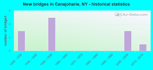
- New bridges - historical statistics
- 31930-1939
- 51950-1959
- 32000-2009
- 12010-2019

- Reconstructed bridges - Historical Statistics
- 21970-1979
- 01980-1989
- 11990-1999
- 12000-2009


- Bridge Condition - Deck
- 11.1%Excellent
- 11.1%Very good
- 33.3%Good
- 22.2%Satisfactory
- 11.1%Fair
- 11.1%Poor

- Bridge Condition - Superstructure
- 33.3%Excellent
- 11.1%Very good
- 11.1%Good
- 22.2%Satisfactory
- 11.1%Poor
- 11.1%Serious

- Bridge Condition - Substructure
- 33.3%Excellent
- 11.1%Good
- 33.3%Satisfactory
- 11.1%Fair
- 11.1%Poor

- Bridge Condition - Channel
- 28.6%Excellent
- 14.3%Very good
- 28.6%Good
- 28.6%Satisfactory
Find on map >> Show street view
Structure Number: 100283, Location: 01MI E JCT RTS 10+5S (Lat: 42.905794, Lng: -74.570631), Route carried "on" structure: State highway 5S, Year Built: 1931, Year Reconstructed: 1984, Status: Open, Structure Length: 2.77m (9.09ft), Average Daily Traffic: 4,878 (year 2020), Truck Traffic: 13%, Average Future Daily Traffic: 6,035 (year 2040), Design Load: HS 20, Features Intersected: CANAJOHARIE CREEK
Minimum Vertical Clearance: 30+ m (98+ ft), Kilometerpoint: 17.602, Lanes on structure: 2, Base Highway Network: Yes, Owner: State Highway Agency, Approaching Roadway Width: 8.8m (28.9ft), Skew: 2 degrees, Material/Design: Steel, Design/Construction: Girder and Floorbeam System, Number Of Spans In Main Unit: 1, Length of Maximum Span: 25.9m (85.0ft), Curb or Sidewalk Widths: Left: 1.8m (5.9ft), Right: 1.8m (5.9ft), Curb-To-Curb Width: 9.1m (29.9ft), Out-to-Out Width: 10.2m (33.5ft)
Condition: Deck: Satisfactory, Superstructure: Poor, Substructure: Fair, Channel: Satisfactory, Operating Rating: 15.2 metric tons, Method Used To Determine Operating Rating: Load and Resistance Factor Rating (LRFR) rating reported by rating factor(RF) method using HL-93 loadings, Inventory Rating: 11.7 metric tons, Method Used To Determine Inventory Rating: Load and Resistance Factor Rating (LRFR) rating reported by rating factor(RF) method using HL-93 loadings, Structural Evaluation: High priority of corrective action, Deck Geometry: Meets minimum limits, Waterway Adequacy: Somewhat better than minimum adequacy, Approach Roadway Alignment: Equal to present desirable criteria, Length Of Structure Improvement: 2.77m (9.09ft), Designated Inspection Frequency: Every 24 months, Critical Feature Inspection Frequency: Every 12 months, Inspection Date: October 2021, Critical Feature Inspection Date: October 2021, Bridge Improvement Cost: $719,000, Roadway Improvement Cost: $421,000, Total Project Cost: $1,140,000 ( Estimate for 2021), Deck Structure Type: Concrete Cast-file-Place, Wearing Surface/Protective System: Wearing Surface: Integral Concrete, Deck Protection: Epoxy Coated Reinforcing
Find on map >> Show street view
Structure Number: 226693, Location: AT CANAJOHARIE (Lat: 42.907747, Lng: -74.569456), Route carried "on" structure: Other road , Year Built: 1953, Status: Closed, Structure Length: 5.18m (16.99ft), Average Daily Traffic: 26 (year 2016), Average Future Daily Traffic: 36 (year 2036), Design Load: HS 20+Mod, Features Intersected: CANAJOHARIE CREEK, Facility Carried by Structure: INCINERATOR ROAD
Minimum Vertical Clearance: 30+ m (98+ ft), Kilometerpoint: 0.113, Lanes on structure: 2, Owner: State Toll Authority, Maintenance Responsibility: Town or Township Highway Agency, Approaching Roadway Width: 12.8m (42.0ft), Material/Design: Steel, Design/Construction: Stringer/Multi-beam, Number Of Spans In Main Unit: 3, Length of Maximum Span: 25.9m (85.0ft), Curb or Sidewalk Widths: Left: 1.1m (3.6ft), Right: 1.1m (3.6ft), Curb-To-Curb Width: 11.0m (36.1ft), Out-to-Out Width: 13.1m (43.0ft)
Condition: Deck: Poor, Superstructure: Serious, Substructure: Poor, Channel: Good, Deck Geometry: Superior to present desirable criteria, Waterway Adequacy: Somewhat better than minimum adequacy, Approach Roadway Alignment: Meets minimum limits, Bridge Posting: Required (Relationship of Operating Rating to Maximum Legal Load: > 39.9% below), Length Of Structure Improvement: 5.18m (16.99ft), Designated Inspection Frequency: Every 12 months, Inspection Date: September 2021, Bridge Improvement Cost: $1,092,000, Roadway Improvement Cost: $640,000, Total Project Cost: $1,732,000 ( Estimate for 2021), Deck Structure Type: Concrete Cast-file-Place, Wearing Surface/Protective System: Wearing Surface: Bituminous
Find on map >> Show street view
Structure Number: 330973, Location: 2.5 MI SE OF CANAJOHARIE (Lat: 42.876331, Lng: -74.602767), Route carried "on" structure: Other road , Year Built: 2016, Status: Open, Structure Length: 2.50m (8.20ft), Average Daily Traffic: 93 (year 2018), Truck Traffic: 5%, Average Future Daily Traffic: 130 (year 2038), Design Load: HL 93, Features Intersected: CANAJOHARIE CREEK, Facility Carried by Structure: MC EWAN ROAD
Minimum Vertical Clearance: 30+ m (98+ ft), Kilometerpoint: 0.418, Lanes on structure: 2, Owner: County Highway Agency, Approaching Roadway Width: 9.1m (29.9ft), Material/Design: Prestressed concrete, Design/Construction: Box Beam or Girders - Multiple, Number Of Spans In Main Unit: 1, Length of Maximum Span: 24.4m (80.1ft), Curb-To-Curb Width: 9.1m (29.9ft), Out-to-Out Width: 10.1m (33.1ft)
Condition: Deck: Excellent, Superstructure: Excellent, Substructure: Excellent, Channel: Very good, Operating Rating: 68.9 metric tons, Method Used To Determine Operating Rating: Load Factor (LF), Inventory Rating: 41.7 metric tons, Method Used To Determine Inventory Rating: Load Factor (LF), Structural Evaluation: Superior to present desirable criteria, Deck Geometry: Better than present minimum criteria, Waterway Adequacy: Meets minimum limits, Approach Roadway Alignment: Equal to present minimum criteria, Length Of Structure Improvement: 2.49m (8.17ft), Designated Inspection Frequency: Every 24 months, Inspection Date: September 2020, Bridge Improvement Cost: $716,000, Roadway Improvement Cost: $419,000, Total Project Cost: $1,136,000 ( Estimate for 2021), Deck Structure Type: Concrete Cast-file-Place, Wearing Surface/Protective System: Wearing Surface: Integral Concrete, Deck Protection: Epoxy Coated Reinforcing
Find on map >> Show street view
Structure Number: 330981, Location: AT CANAJOHARIE (Lat: 42.902761, Lng: -74.573706), Route carried "on" structure: Other road , Year Built: 1935, Year Reconstructed: 1999, Status: Open, Structure Length: 2.19m (7.19ft), Average Daily Traffic: 84 (year 2016), Average Future Daily Traffic: 118 (year 2036), Features Intersected: CANAJOHARIE CREEK, Facility Carried by Structure: CREEK ROAD
Minimum Vertical Clearance: 30+ m (98+ ft), Kilometerpoint: 0.000, Lanes on structure: 2, Owner: County Highway Agency, Approaching Roadway Width: 6.7m (22.0ft), Material/Design: Steel, Design/Construction: Stringer/Multi-beam, Number Of Spans In Main Unit: 1, Length of Maximum Span: 21.0m (68.9ft), Curb-To-Curb Width: 6.9m (22.6ft), Out-to-Out Width: 7.5m (24.6ft)
Condition: Deck: Good, Superstructure: Good, Substructure: Satisfactory, Channel: Satisfactory, Operating Rating: 39.0 metric tons, Method Used To Determine Operating Rating: Load Factor (LF), Inventory Rating: 14.5 metric tons, Method Used To Determine Inventory Rating: Load Factor (LF), Structural Evaluation: Meets minimum limits, Deck Geometry: Somewhat better than minimum adequacy, Waterway Adequacy: Meets minimum limits, Approach Roadway Alignment: Somewhat better than minimum adequacy, Length Of Structure Improvement: 2.19m (7.19ft), Designated Inspection Frequency: Every 24 months, Inspection Date: October 2021, Bridge Improvement Cost: $373,000, Roadway Improvement Cost: $219,000, Total Project Cost: $592,000 ( Estimate for 2021), Deck Structure Type: Concrete Cast-file-Place, Wearing Surface/Protective System: Wearing Surface: Bituminous, Membrane: Other
Find on map >> Show street view
Structure Number: 330983, Location: IN CANAJOHARIE (Lat: 42.905014, Lng: -74.571464), Route carried "on" structure: Other road , Year Built: 1933, Status: Open, Structure Length: 2.19m (7.19ft), Average Daily Traffic: 3,774 (year 2018), Truck Traffic: 3%, Average Future Daily Traffic: 4,669 (year 2040), Design Load: H 20, Features Intersected: CANAJOHARIE CREEK, Facility Carried by Structure: MONTGOMERY STREET
Minimum Vertical Clearance: 30+ m (98+ ft), Kilometerpoint: 0.064, Lanes on structure: 2, Owner: County Highway Agency, Approaching Roadway Width: 7.6m (24.9ft), Skew: 1 degrees, Material/Design: Concrete, Design/Construction: Frame, Number Of Spans In Main Unit: 1, Length of Maximum Span: 21.6m (70.9ft), Curb or Sidewalk Widths: Left: 1.5m (4.9ft), Right: 1.5m (4.9ft), Curb-To-Curb Width: 7.6m (24.9ft), Out-to-Out Width: 11.4m (37.4ft)
Condition: Deck: Fair, Superstructure: Satisfactory, Substructure: Satisfactory, Channel: Good, Operating Rating: 56.5 metric tons, Method Used To Determine Operating Rating: Field evaluation and documented engineering judgment, Inventory Rating: 14.1 metric tons, Method Used To Determine Inventory Rating: Field evaluation and documented engineering judgment, Structural Evaluation: Meets minimum limits, Deck Geometry: High priority of replacement, Waterway Adequacy: Somewhat better than minimum adequacy, Approach Roadway Alignment: Somewhat better than minimum adequacy, Length Of Structure Improvement: 2.19m (7.19ft), Designated Inspection Frequency: Every 24 months, Inspection Date: June 2021, Bridge Improvement Cost: $709,000, Roadway Improvement Cost: $415,000, Total Project Cost: $1,124,000 ( Estimate for 2021)
Find on map >> Show street view
Structure Number: 400795, Location: .3 MILE S JCT SH 5 & SH10 (Lat: 42.910081, Lng: -74.570892), Route carried "on" structure: State highway 10, Year Built: 2008, Status: Open, Structure Length: 19.35m (63.48ft), Average Daily Traffic: 7,599 (year 2020), Truck Traffic: 7%, Average Future Daily Traffic: 9,231 (year 2040), Design Load: HL 93, Features Intersected: NYS BARGE CANAL, CSX TRA
Minimum Vertical Clearance: 30+ m (98+ ft), Kilometerpoint: 12.904, Lanes on structure: 2, Base Highway Network: Yes, Owner: State Highway Agency, Approaching Roadway Width: 12.2m (40.0ft), Skew: 20 degrees, Navigation Control: Yes ( Vertical Clearance: 999.9m (3,280.5ft), Horizontal Clearance: 8.5m (27.9ft)), Material/Design: Steel continuous, Design/Construction: Stringer/Multi-beam, Number Of Spans In Main Unit: 3, Length of Maximum Span: 80.0m (262.5ft), Curb or Sidewalk Widths: Left: 1.7m (5.6ft), Right: 1.7m (5.6ft), Curb-To-Curb Width: 12.3m (40.4ft), Out-to-Out Width: 16.4m (53.8ft)
Condition: Deck: Very good, Superstructure: Excellent, Substructure: Excellent, Channel: Excellent, Operating Rating: 99.8 metric tons, Method Used To Determine Operating Rating: Load Factor (LF), Inventory Rating: 59.9 metric tons, Method Used To Determine Inventory Rating: Load Factor (LF), Structural Evaluation: Superior to present desirable criteria, Deck Geometry: Somewhat better than minimum adequacy, Underclear: Superior to present desirable criteria, Waterway Adequacy: Equal to present minimum criteria, Approach Roadway Alignment: Equal to present desirable criteria, Length Of Structure Improvement: 19.35m (63.48ft), Designated Inspection Frequency: Every 24 months, Underwater Inspection Frequency: Every 60 months, Inspection Date: November 2020, Underwater Inspection Date: December 2017, Bridge Improvement Cost: $5,081,000, Roadway Improvement Cost: $2,975,000, Total Project Cost: $8,056,000 ( Estimate for 2021), Deck Structure Type: Concrete Cast-file-Place, Wearing Surface/Protective System: Wearing Surface: Integral Concrete, Deck Protection: Epoxy Coated Reinforcing
Find on map >> Show street view
Structure Number: 5007949, Location: .5 MI W OF I90 EXIT 29 (Lat: 42.908192, Lng: -74.571192), Route carried "on" structure: Interstate 90, Year Built: 2000, Status: Open, Structure Length: 3.72m (12.20ft), Average Daily Traffic: 19,610 (year 2020), Truck Traffic: 31%, Average Future Daily Traffic: 22,594 (year 2040), Design Load: HS 25 or greater, Features Intersected: RTE 10
Minimum Vertical Clearance: 30+ m (98+ ft), Kilometerpoint: 18.970, Lanes on structure: 4, Lanes under structure: 2, Base Highway Network: Yes, Toll: On Interstate toll segment, Owner: State Toll Authority, Approaching Roadway Width: 32.9m (107.9ft), Skew: 31 degrees, Material/Design: Steel, Design/Construction: Stringer/Multi-beam, Number Of Spans In Main Unit: 1, Length of Maximum Span: 36.0m (118.1ft), Curb-To-Curb Width: 33.1m (108.6ft), Out-to-Out Width: 35.0m (114.8ft)
Condition: Deck: Good, Superstructure: Excellent, Substructure: Excellent, Operating Rating: 88.9 metric tons, Method Used To Determine Operating Rating: Load Factor (LF), Inventory Rating: 52.6 metric tons, Method Used To Determine Inventory Rating: Load Factor (LF), Structural Evaluation: Superior to present desirable criteria, Deck Geometry: Superior to present desirable criteria, Underclear: Meets minimum limits, Approach Roadway Alignment: Equal to present desirable criteria, Length Of Structure Improvement: 3.71m (12.17ft), Designated Inspection Frequency: Every 24 months, Inspection Date: November 2020, Bridge Improvement Cost: $2,650,000, Roadway Improvement Cost: $1,552,000, Total Project Cost: $4,202,000 ( Estimate for 2021), Deck Structure Type: Concrete Cast-file-Place, Wearing Surface/Protective System: Wearing Surface: Integral Concrete, Deck Protection: Galvanized Reinforcing
Find on map >> Show street view
Structure Number: 551594, Location: AT VILLAGE OF CANAJOHARIE (Lat: 42.906894, Lng: -74.562350), Route carried "on" structure: Ramp Interstate , Year Built: 1955, Year Reconstructed: 1982, Status: Open, Structure Length: 6.37m (20.90ft), Average Daily Traffic: 576 (year 2020), Truck Traffic: 28%, Average Future Daily Traffic: 663 (year 2040), Design Load: HS 20+Mod, Features Intersected: 90IX EB, RTE I90, Facility Carried by Structure: CANAJOHARIE INTER
Minimum Vertical Clearance: 30+ m (98+ ft), Kilometerpoint: 0.241, Lanes on structure: 2, Lanes under structure: 5, Toll: On Interstate toll segment, Owner: State Toll Authority, Approaching Roadway Width: 12.2m (40.0ft), Skew: 30 degrees, Material/Design: Steel, Design/Construction: Stringer/Multi-beam, Number Of Spans In Main Unit: 4, Length of Maximum Span: 19.8m (65.0ft), Curb-To-Curb Width: 12.2m (40.0ft), Out-to-Out Width: 13.1m (43.0ft)
Condition: Deck: Satisfactory, Superstructure: Satisfactory, Substructure: Satisfactory, Operating Rating: 75.3 metric tons, Method Used To Determine Operating Rating: Load Factor (LF), Inventory Rating: 44.5 metric tons, Method Used To Determine Inventory Rating: Load Factor (LF), Structural Evaluation: Equal to present minimum criteria, Deck Geometry: Superior to present desirable criteria, Underclear: High priority of corrective action, Approach Roadway Alignment: Equal to present desirable criteria, Length Of Structure Improvement: 6.37m (20.90ft), Designated Inspection Frequency: Every 24 months, Inspection Date: August 2021, Bridge Improvement Cost: $1,340,000, Roadway Improvement Cost: $784,000, Total Project Cost: $2,124,000 ( Estimate for 2021), Deck Structure Type: Concrete Cast-file-Place, Wearing Surface/Protective System: Wearing Surface: Bituminous, Membrane: Preformed Fabric
Find on map >> Show street view
Structure Number: 5515959, Location: JCT I-90 < CANAJOHARIE CK (Lat: 42.908131, Lng: -74.569114), Route carried "on" structure: Interstate 90, Year Built: 1955, Year Reconstructed: 2000, Status: Open, Structure Length: 11.64m (38.19ft), Average Daily Traffic: 19,610 (year 2020), Truck Traffic: 31%, Average Future Daily Traffic: 22,594 (year 2040), Design Load: HS 25 or greater, Features Intersected: INCINERATOR ROAD, CANAJO
Minimum Vertical Clearance: 30+ m (98+ ft), Kilometerpoint: 19.099, Lanes on structure: 4, Lanes under structure: 2, Base Highway Network: Yes, Toll: On Interstate toll segment, Owner: State Toll Authority, Approaching Roadway Width: 34.4m (112.9ft), Skew: 21 degrees, Material/Design: Steel continuous, Design/Construction: Stringer/Multi-beam, Number Of Spans In Main Unit: 5, Length of Maximum Span: 28.7m (94.2ft), Curb-To-Curb Width: 33.1m (108.6ft), Out-to-Out Width: 34.6m (113.5ft)
Condition: Deck: Good, Superstructure: Very good, Substructure: Good, Channel: Excellent, Operating Rating: 45.4 metric tons, Method Used To Determine Operating Rating: Load and Resistance Factor Rating (LRFR) rating reported by rating factor(RF) method using HL-93 loadings, Inventory Rating: 35.0 metric tons, Method Used To Determine Inventory Rating: Load and Resistance Factor Rating (LRFR) rating reported by rating factor(RF) method using HL-93 loadings, Structural Evaluation: Better than present minimum criteria, Deck Geometry: Superior to present desirable criteria, Underclear: Meets minimum limits, Waterway Adequacy: Equal to present minimum criteria, Approach Roadway Alignment: Equal to present desirable criteria, Length Of Structure Improvement: 11.64m (38.19ft), Designated Inspection Frequency: Every 24 months, Inspection Date: June 2020, Bridge Improvement Cost: $6,327,000, Roadway Improvement Cost: $3,705,000, Total Project Cost: $10,032,000 ( Estimate for 2021), Deck Structure Type: Concrete Cast-file-Place, Wearing Surface/Protective System: Wearing Surface: Integral Concrete, Deck Protection: Galvanized Reinforcing
Find on map >> Show street view
Structure Number: 5007949, Location: .5 MI W OF I90 EXIT 29 (Lat: 42.908192, Lng: -74.571192), Route carried "under" structure: State highway 10, Year Built: 2000, Structure Length: 0. m, Average Daily Traffic: 7,995 (year 1999), Features Intersected: RTE 10, Facility Carried by Structure: RTE I90
Minimum Vertical Clearance: 4.55m (14.93ft), Kilometerpoint: 12.904, Lanes on structure: 4, Lanes under structure: 2, Material/Design: Steel, Design/Construction: Stringer/Multi-beam, Length of Maximum Span: 36.0m (118.1ft)
Find on map >> Show street view
Structure Number: 551594, Location: AT VILLAGE OF CANAJOHARIE (Lat: 42.906894, Lng: -74.562350), Route carried "under" structure: Interstate 90, Year Built: 1955, Structure Length: 0. m, Average Daily Traffic: 11,680 (year 1977), Features Intersected: 90IX EB, RTE I90, Facility Carried by Structure: CANAJOHARIE INTER
Minimum Vertical Clearance: 4.80m (15.75ft), Kilometerpoint: 312.307, Lanes on structure: 2, Lanes under structure: 3, Toll: On Interstate toll segment, Material/Design: Steel, Design/Construction: Stringer/Multi-beam, Length of Maximum Span: 19.8m (65.0ft)
Find on map >> Show street view
Structure Number: 5515959, Location: JCT I-90 < CANAJOHARIE CK (Lat: 42.908131, Lng: -74.569114), Route carried "under" structure: Other road , Year Built: 1955, Structure Length: 0. m, Average Daily Traffic: 26 (year 2016), Features Intersected: INCINERATOR ROAD, CANAJO, Facility Carried by Structure: RTE I90
Minimum Vertical Clearance: 4.50m (14.76ft), Kilometerpoint: 0.113, Lanes on structure: 4, Lanes under structure: 2, Material/Design: Steel continuous, Design/Construction: Stringer/Multi-beam, Length of Maximum Span: 28.7m (94.2ft)