Bridge Statistics for Canastota, New York (NY)
Condition, Traffic, Stress, Structural Evaluation, Project Costs
- National Bridge Inventory (NBI) Statistics
- 17Number of bridges
- 98ft / 30.2mTotal length
- $13,424,000Total costs
- 162,329Total average daily traffic
- 19,164Total average daily truck traffic
- National Bridge Inventory (NBI) Registered Bridges for Canastota
- No street view available for this location
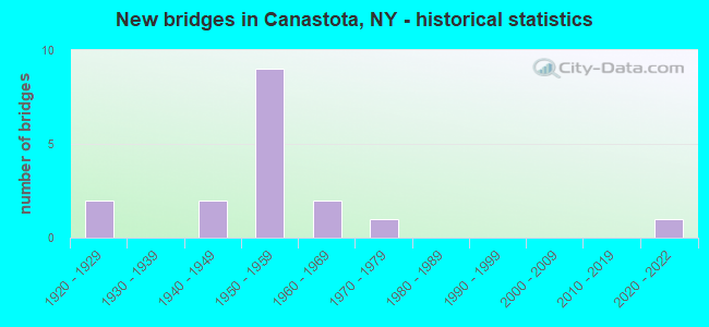
- New bridges - historical statistics
- 21920-1929
- 21940-1949
- 91950-1959
- 21960-1969
- 11970-1979
- 12020-2022


- Bridge Condition - Deck
- 10.0%Excellent
- 10.0%Very good
- 30.0%Satisfactory
- 30.0%Fair
- 20.0%Poor

- Bridge Condition - Superstructure
- 10.0%Excellent
- 10.0%Good
- 20.0%Satisfactory
- 40.0%Fair
- 20.0%Poor

- Bridge Condition - Substructure
- 10.0%Excellent
- 40.0%Good
- 10.0%Satisfactory
- 20.0%Fair
- 20.0%Poor

- Bridge Condition - Channel
- 11.1%Excellent
- 44.4%Good
- 33.3%Satisfactory
- 11.1%Fair

- Bridge Condition - Culverts
- 50.0%Satisfactory
- 50.0%Fair
Find on map >> Show street view
Structure Number: 101059, Location: NORTH PETERBORO ST RT 13 (Lat: 43.091347, Lng: -75.751372), Route carried "on" structure: State highway 13, Year Built: 1954, Status: Open, Structure Length: 6.46m (21.19ft), Average Daily Traffic: 9,896 (year 2020), Truck Traffic: 9%, Average Future Daily Traffic: 12,021 (year 2040), Design Load: HS 20, Features Intersected: 90IX EB, RTE I90
Minimum Vertical Clearance: 30+ m (98+ ft), Kilometerpoint: 52.968, Lanes on structure: 2, Lanes under structure: 5, Base Highway Network: Yes, Owner: State Highway Agency, Maintenance Responsibility: State Toll Authority, Approaching Roadway Width: 9.4m (30.8ft), Material/Design: Steel, Design/Construction: Stringer/Multi-beam, Number Of Spans In Main Unit: 4, Length of Maximum Span: 20.7m (67.9ft), Curb-To-Curb Width: 9.4m (30.8ft), Out-to-Out Width: 10.5m (34.4ft)
Condition: Deck: Poor, Superstructure: Fair, Substructure: Poor, Operating Rating: 45.4 metric tons, Method Used To Determine Operating Rating: Load Factor (LF), Inventory Rating: 32.7 metric tons, Method Used To Determine Inventory Rating: Load Factor (LF), Structural Evaluation: Meets minimum limits, Deck Geometry: Meets minimum limits, Underclear: High priority of corrective action, Approach Roadway Alignment: Equal to present minimum criteria, Length Of Structure Improvement: 6.46m (21.19ft), Designated Inspection Frequency: Every 24 months, Critical Feature Inspection Frequency: Every 24 months, Inspection Date: October 2021, Critical Feature Inspection Date: October 2021, Bridge Improvement Cost: $1,090,000, Roadway Improvement Cost: $638,000, Total Project Cost: $1,728,000 ( Estimate for 2021), Deck Structure Type: Concrete Cast-file-Place, Wearing Surface/Protective System: Wearing Surface: Bituminous, Membrane: Other
Find on map >> Show street view
Structure Number: 10106, Location: JCT RT 13 + COWASELON CK (Lat: 43.095533, Lng: -75.751322), Route carried "on" structure: State highway 13, Year Built: 1976, Status: Open, Structure Length: 2.13m (6.99ft), Average Daily Traffic: 4,245 (year 2020), Truck Traffic: 9%, Average Future Daily Traffic: 5,156 (year 2040), Design Load: HS 20, Features Intersected: COWASELON CREEK
Minimum Vertical Clearance: 30+ m (98+ ft), Kilometerpoint: 53.451, Lanes on structure: 2, Base Highway Network: Yes, Owner: State Highway Agency, Approaching Roadway Width: 13.4m (44.0ft), Material/Design: Prestressed concrete, Design/Construction: Box Beam or Girders - Multiple, Number Of Spans In Main Unit: 1, Length of Maximum Span: 20.1m (65.9ft), Curb-To-Curb Width: 13.4m (44.0ft), Out-to-Out Width: 14.1m (46.3ft)
Condition: Deck: Fair, Superstructure: Poor, Substructure: Good, Channel: Good, Operating Rating: 58.1 metric tons, Method Used To Determine Operating Rating: Load Factor (LF), Inventory Rating: 19.1 metric tons, Method Used To Determine Inventory Rating: Load Factor (LF), Structural Evaluation: Meets minimum limits, Deck Geometry: Better than present minimum criteria, Waterway Adequacy: Meets minimum limits, Approach Roadway Alignment: Equal to present desirable criteria, Length Of Structure Improvement: 2.13m (6.99ft), Designated Inspection Frequency: Every 24 months, Inspection Date: June 2021, Bridge Improvement Cost: $697,000, Roadway Improvement Cost: $408,000, Total Project Cost: $1,105,000 ( Estimate for 2021), Wearing Surface/Protective System: Wearing Surface: Monolithic Concrete
Find on map >> Show street view
Structure Number: 226327, Location: 0.33 MI SW OF CANASTOTA (Lat: 43.086244, Lng: -75.768256), Route carried "on" structure: County highway , Year Built: 2021, Status: Open, Structure Length: 1.67m (5.48ft), Average Daily Traffic: 2,260 (year 2020), Truck Traffic: 7%, Average Future Daily Traffic: 2,796 (year 2040), Features Intersected: OWLVILLE CREEK, Facility Carried by Structure: CR 6 NEW BOSTON ST
Minimum Vertical Clearance: 30+ m (98+ ft), Kilometerpoint: 17.940, Lanes on structure: 2, Owner: Town or Township Highway Agency, Approaching Roadway Width: 6.1m (20.0ft), Skew: 2 degrees, Material/Design: Prestressed concrete, Design/Construction: Slab, Number Of Spans In Main Unit: 1, Length of Maximum Span: 15.5m (50.9ft), Curb-To-Curb Width: 8.9m (29.2ft), Out-to-Out Width: 9.9m (32.5ft)
Condition: Deck: Excellent, Superstructure: Excellent, Substructure: Excellent, Channel: Satisfactory, Operating Rating: 89.8 metric tons, Method Used To Determine Operating Rating: Load Factor (LF), Inventory Rating: 47.2 metric tons, Method Used To Determine Inventory Rating: Load Factor (LF), Structural Evaluation: Superior to present desirable criteria, Deck Geometry: Meets minimum limits, Waterway Adequacy: Meets minimum limits, Approach Roadway Alignment: Somewhat better than minimum adequacy, Length Of Structure Improvement: 0.64m (2.10ft), Designated Inspection Frequency: Every 24 months, Inspection Date: December 2021, Bridge Improvement Cost: $76,000, Roadway Improvement Cost: $44,000, Total Project Cost: $120,000 ( Estimate for 2021)
Find on map >> Show street view
Structure Number: 230928, Location: 1 MI NORTH OF CANASTOTA (Lat: 43.096933, Lng: -75.760203), Route carried "on" structure: County highway , Year Built: 1949, Year Reconstructed: 1963, Status: Open, Structure Length: 1.83m (6.00ft), Average Daily Traffic: 1,028 (year 2018), Truck Traffic: 5%, Average Future Daily Traffic: 1,271 (year 2040), Features Intersected: COWASELON CREEK, Facility Carried by Structure: NORTH MAIN STREET
Minimum Vertical Clearance: 30+ m (98+ ft), Kilometerpoint: 1.158, Lanes on structure: 2, Owner: County Highway Agency, Approaching Roadway Width: 6.7m (22.0ft), Skew: 2 degrees, Material/Design: Steel, Design/Construction: Stringer/Multi-beam, Number Of Spans In Main Unit: 1, Length of Maximum Span: 18.0m (59.1ft), Curb-To-Curb Width: 7.4m (24.3ft), Out-to-Out Width: 8.2m (26.9ft)
Condition: Deck: Satisfactory, Superstructure: Good, Substructure: Satisfactory, Channel: Fair, Operating Rating: 22.7 metric tons, Method Used To Determine Operating Rating: Load and Resistance Factor Rating (LRFR) rating reported by rating factor(RF) method using HL-93 loadings, Inventory Rating: 17.5 metric tons, Method Used To Determine Inventory Rating: Load and Resistance Factor Rating (LRFR) rating reported by rating factor(RF) method using HL-93 loadings, Structural Evaluation: Meets minimum limits, Deck Geometry: Meets minimum limits, Waterway Adequacy: Meets minimum limits, Approach Roadway Alignment: Equal to present minimum criteria, Length Of Structure Improvement: 1.82m (5.97ft), Designated Inspection Frequency: Every 24 months, Inspection Date: June 2020, Bridge Improvement Cost: $398,000, Roadway Improvement Cost: $233,000, Total Project Cost: $631,000 ( Estimate for 2021), Deck Structure Type: Concrete Cast-file-Place, Wearing Surface/Protective System: Wearing Surface: Bituminous
Find on map >> Show street view
Structure Number: 401058, Location: 07MI N JCT RTS 5+13 (Lat: 43.079242, Lng: -75.751247), Route carried "on" structure: State highway 13, Year Built: 1928, Year Reconstructed: 1957, Status: Open, Structure Length: 0.70m (2.30ft), Average Daily Traffic: 9,896 (year 2020), Truck Traffic: 9%, Average Future Daily Traffic: 12,021 (year 2040), Design Load: H 15, Features Intersected: Old Erie Canal
Minimum Vertical Clearance: 30+ m (98+ ft), Kilometerpoint: 51.617, Lanes on structure: 2, Base Highway Network: Yes, Owner: State Highway Agency, Approaching Roadway Width: 14.0m (45.9ft), Material/Design: Concrete, Design/Construction: Slab, Number Of Spans In Main Unit: 1, Length of Maximum Span: 6.0m (19.7ft), Curb or Sidewalk Widths: Left: 2.3m (7.5ft), Right: 1.8m (5.9ft), Curb-To-Curb Width: 14.0m (45.9ft), Out-to-Out Width: 18.1m (59.4ft)
Condition: Deck: Very good, Superstructure: Fair, Substructure: Fair, Channel: Excellent, Operating Rating: 51.9 metric tons, Method Used To Determine Operating Rating: Field evaluation and documented engineering judgment, Inventory Rating: 24.5 metric tons, Method Used To Determine Inventory Rating: Field evaluation and documented engineering judgment, Structural Evaluation: Somewhat better than minimum adequacy, Deck Geometry: Superior to present desirable criteria, Waterway Adequacy: Equal to present desirable criteria, Approach Roadway Alignment: Equal to present desirable criteria, Length Of Structure Improvement: 0.70m (2.30ft), Designated Inspection Frequency: Every 24 months, Underwater Inspection Frequency: Every 60 months, Inspection Date: September 2021, Underwater Inspection Date: May 2015, Bridge Improvement Cost: $589,000, Roadway Improvement Cost: $345,000, Total Project Cost: $934,000 ( Estimate for 2021), Wearing Surface/Protective System: Wearing Surface: Bituminous
Find on map >> Show street view
Structure Number: 442402, Location: N CANASTOTA E RTE13 (Lat: 43.079222, Lng: -75.750389), Route carried "on" structure: City street , Year Built: 1947, Status: Open, Structure Length: 0.82m (2.69ft), Average Daily Traffic: 565 (year 2020), Truck Traffic: 5%, Average Future Daily Traffic: 699 (year 2040), Design Load: H 20, Features Intersected: OLD ERIE CANAL, Facility Carried by Structure: DIAMOND ST
Minimum Vertical Clearance: 30+ m (98+ ft), Kilometerpoint: 0.129, Lanes on structure: 2, Owner: State Highway Agency, Approaching Roadway Width: 8.5m (27.9ft), Skew: 1 degrees, Material/Design: Concrete, Design/Construction: Slab, Number Of Spans In Main Unit: 1, Length of Maximum Span: 7.3m (24.0ft), Curb or Sidewalk Widths: Left: 0.0m, Right: 1.5m (4.9ft), Curb-To-Curb Width: 7.5m (24.6ft), Out-to-Out Width: 14.9m (48.9ft)
Condition: Deck: Satisfactory, Superstructure: Satisfactory, Substructure: Good, Channel: Good, Operating Rating: 63.5 metric tons, Method Used To Determine Operating Rating: Load Factor (LF), Inventory Rating: 38.1 metric tons, Method Used To Determine Inventory Rating: Load Factor (LF), Structural Evaluation: Equal to present minimum criteria, Deck Geometry: Meets minimum limits, Waterway Adequacy: Equal to present minimum criteria, Approach Roadway Alignment: Equal to present desirable criteria, Length Of Structure Improvement: 0.82m (2.69ft), Designated Inspection Frequency: Every 24 months, Inspection Date: October 2020, Bridge Improvement Cost: $390,000, Roadway Improvement Cost: $228,000, Total Project Cost: $618,000 ( Estimate for 2021), Wearing Surface/Protective System: Wearing Surface: Bituminous
Find on map >> Show street view
Structure Number: 442404, Location: N CANASTOTA VILLAGE S (Lat: 43.079353, Lng: -75.757083), Route carried "on" structure: City street , Year Built: 1950, Status: Open, Structure Length: 0.76m (2.49ft), Average Daily Traffic: 139 (year 2016), Truck Traffic: 5%, Average Future Daily Traffic: 195 (year 2036), Design Load: H 20, Features Intersected: OLD ERIE CANAL, Facility Carried by Structure: BUCK ST
Minimum Vertical Clearance: 30+ m (98+ ft), Kilometerpoint: 0.048, Lanes on structure: 2, Owner: State Highway Agency, Approaching Roadway Width: 8.5m (27.9ft), Material/Design: Concrete, Design/Construction: Slab, Number Of Spans In Main Unit: 1, Length of Maximum Span: 7.3m (24.0ft), Curb or Sidewalk Widths: Left: 1.5m (4.9ft), Right: 1.5m (4.9ft), Curb-To-Curb Width: 8.6m (28.2ft), Out-to-Out Width: 12.2m (40.0ft)
Condition: Deck: Satisfactory, Superstructure: Satisfactory, Substructure: Good, Channel: Good, Operating Rating: 62.6 metric tons, Method Used To Determine Operating Rating: Load Factor (LF), Inventory Rating: 37.2 metric tons, Method Used To Determine Inventory Rating: Load Factor (LF), Structural Evaluation: Equal to present minimum criteria, Deck Geometry: Equal to present minimum criteria, Waterway Adequacy: Equal to present minimum criteria, Approach Roadway Alignment: Equal to present desirable criteria, Length Of Structure Improvement: 0.76m (2.49ft), Designated Inspection Frequency: Every 24 months, Inspection Date: October 2020, Bridge Improvement Cost: $312,000, Roadway Improvement Cost: $183,000, Total Project Cost: $495,000 ( Estimate for 2021), Wearing Surface/Protective System: Wearing Surface: Bituminous
Find on map >> Show street view
Structure Number: 442412, Location: VILLAGE OF CANASTOTA (Lat: 43.079447, Lng: -75.754969), Route carried "on" structure: Other road , Year Built: 1927, Status: Posted for load-capacity, Structure Length: 0.70m (2.30ft), Average Daily Traffic: 5,853 (year 2020), Truck Traffic: 4%, Average Future Daily Traffic: 7,241 (year 2040), Features Intersected: OLD ERIE CANAL, Facility Carried by Structure: MAIN STREET
Minimum Vertical Clearance: 30+ m (98+ ft), Kilometerpoint: 1.126, Lanes on structure: 2, Owner: State Highway Agency, Approaching Roadway Width: 8.5m (27.9ft), Material/Design: Concrete, Design/Construction: Slab, Number Of Spans In Main Unit: 1, Length of Maximum Span: 6.4m (21.0ft), Curb or Sidewalk Widths: Left: 1.5m (4.9ft), Right: 1.5m (4.9ft), Curb-To-Curb Width: 8.5m (27.9ft), Out-to-Out Width: 12.0m (39.4ft)
Condition: Deck: Poor, Superstructure: Poor, Substructure: Fair, Channel: Good, Operating Rating: 36.0 metric tons, Method Used To Determine Operating Rating: Load and Resistance Factor Rating (LRFR) rating reported by rating factor(RF) method using HL-93 loadings, Inventory Rating: 27.5 metric tons, Method Used To Determine Inventory Rating: Load and Resistance Factor Rating (LRFR) rating reported by rating factor(RF) method using HL-93 loadings, Structural Evaluation: Meets minimum limits, Deck Geometry: High priority of replacement, Waterway Adequacy: Equal to present minimum criteria, Approach Roadway Alignment: Meets minimum limits, Length Of Structure Improvement: 0.70m (2.30ft), Designated Inspection Frequency: Every 12 months, Inspection Date: October 2021, Bridge Improvement Cost: $272,000, Roadway Improvement Cost: $159,000, Total Project Cost: $431,000 ( Estimate for 2021), Wearing Surface/Protective System: Wearing Surface: Bituminous
Find on map >> Show street view
Structure Number: 551279, Location: 0.3 MI W JCT I90&INT 34 (Lat: 43.090494, Lng: -75.756822), Route carried "on" structure: County highway , Year Built: 1953, Status: Temporarily open, Structure Length: 6.10m (20.01ft), Average Daily Traffic: 1,028 (year 2018), Truck Traffic: 5%, Average Future Daily Traffic: 1,271 (year 2040), Design Load: H 20, Features Intersected: 90IX EB, RTE I90, Facility Carried by Structure: NORTH MAIN ST
Minimum Vertical Clearance: 30+ m (98+ ft), Kilometerpoint: 0.386, Lanes on structure: 2, Lanes under structure: 4, Owner: State Toll Authority, Approaching Roadway Width: 6.1m (20.0ft), Skew: 1 degrees, Material/Design: Steel, Design/Construction: Stringer/Multi-beam, Number Of Spans In Main Unit: 4, Length of Maximum Span: 18.6m (61.0ft), Curb or Sidewalk Widths: Left: 0.8m (2.6ft), Right: 0.8m (2.6ft), Curb-To-Curb Width: 8.5m (27.9ft), Out-to-Out Width: 10.6m (34.8ft)
Condition: Deck: Fair, Superstructure: Fair, Substructure: Poor, Operating Rating: 31.8 metric tons, Method Used To Determine Operating Rating: Load Factor (LF), Inventory Rating: 26.3 metric tons, Method Used To Determine Inventory Rating: Load Factor (LF), Structural Evaluation: Meets minimum limits, Deck Geometry: Somewhat better than minimum adequacy, Underclear: High priority of corrective action, Approach Roadway Alignment: Equal to present desirable criteria, Length Of Structure Improvement: 6.09m (19.98ft), Designated Inspection Frequency: Every 24 months, Critical Feature Inspection Frequency: Every 12 months, Inspection Date: July 2021, Critical Feature Inspection Date: July 2021, Bridge Improvement Cost: $1,061,000, Roadway Improvement Cost: $621,000, Total Project Cost: $1,682,000 ( Estimate for 2021), Deck Structure Type: Concrete Cast-file-Place, Wearing Surface/Protective System: Wearing Surface: Monolithic Concrete
Find on map >> Show street view
Structure Number: 551283, Location: EXIT 34 OF I90 (Lat: 43.092483, Lng: -75.747031), Route carried "on" structure: Ramp Interstate , Year Built: 1954, Status: Open, Structure Length: 7.22m (23.69ft), Average Daily Traffic: 4,217 (year 2019), Truck Traffic: 11%, Average Future Daily Traffic: 4,858 (year 2040), Design Load: HS 20+Mod, Features Intersected: 90IX EB, RTE I90, Facility Carried by Structure: EXIT 34 RAMP
Minimum Vertical Clearance: 30+ m (98+ ft), Kilometerpoint: 0.241, Lanes on structure: 2, Lanes under structure: 5, Toll: On Interstate toll segment, Owner: State Toll Authority, Approaching Roadway Width: 11.9m (39.0ft), Skew: 20 degrees, Material/Design: Steel, Design/Construction: Stringer/Multi-beam, Number Of Spans In Main Unit: 4, Length of Maximum Span: 24.1m (79.1ft), Curb-To-Curb Width: 12.4m (40.7ft), Out-to-Out Width: 13.7m (44.9ft)
Condition: Deck: Fair, Superstructure: Fair, Substructure: Good, Operating Rating: 39.9 metric tons, Method Used To Determine Operating Rating: Load Factor (LF), Inventory Rating: 23.6 metric tons, Method Used To Determine Inventory Rating: Load Factor (LF), Structural Evaluation: Somewhat better than minimum adequacy, Deck Geometry: Superior to present desirable criteria, Underclear: High priority of corrective action, Approach Roadway Alignment: Equal to present desirable criteria, Length Of Structure Improvement: 7.22m (23.69ft), Designated Inspection Frequency: Every 24 months, Inspection Date: October 2021, Bridge Improvement Cost: $1,570,000, Roadway Improvement Cost: $920,000, Total Project Cost: $2,490,000 ( Estimate for 2021), Deck Structure Type: Concrete Cast-file-Place, Wearing Surface/Protective System: Wearing Surface: Bituminous, Membrane: Other
Find on map >> Show street view
Structure Number: 55131, Location: 0.7 MI W JCT I90&INT 34 (Lat: 43.090272, Lng: -75.759756), Route carried "on" structure: Interstate 90, Year Built: 1953, Status: Open, Structure Length: 0.70m (2.30ft), Average Daily Traffic: 38,182 (year 2014), Truck Traffic: 23%, Average Future Daily Traffic: 53,455 (year 2034), Design Load: HS 20+Mod, Features Intersected: CANASTOTA CREEK W
Minimum Vertical Clearance: 30+ m (98+ ft), Kilometerpoint: 422.169, Lanes on structure: 4, Base Highway Network: Yes, Toll: On Interstate toll segment, Owner: State Toll Authority, Approaching Roadway Width: 27.4m (89.9ft), Skew: 20 degrees, Material/Design: Concrete, Design/Construction: Culvert, Number Of Spans In Main Unit: 1, Length of Maximum Span: 6.1m (20.0ft), Curb-To-Curb Width: 28.7m (94.2ft), Out-to-Out Width: 45.5m (149.3ft)
Condition: Channel: Satisfactory, Culverts: Satisfactory, Operating Rating: 69.9 metric tons, Method Used To Determine Operating Rating: Load Factor (LF), Inventory Rating: 41.7 metric tons, Method Used To Determine Inventory Rating: Load Factor (LF), Structural Evaluation: Equal to present minimum criteria, Deck Geometry: Superior to present desirable criteria, Waterway Adequacy: Meets minimum limits, Approach Roadway Alignment: Equal to present desirable criteria, Length Of Structure Improvement: 0.70m (2.30ft), Designated Inspection Frequency: Every 24 months, Inspection Date: May 2021, Bridge Improvement Cost: $1,162,000, Roadway Improvement Cost: $680,000, Total Project Cost: $1,842,000 ( Estimate for 2021)
Find on map >> Show street view
Structure Number: 551311, Location: 0.7 MI W JCT I90(Lat: 43.090100, Lng: -75.759531), Route carried "on" structure: Interstate 90, Year Built: 1953, Status: Open, Structure Length: 1.07m (3.51ft), Average Daily Traffic: 32,865 (year 2020), Truck Traffic: 22%, Average Future Daily Traffic: 37,867 (year 2040), Design Load: HS 20+Mod, Features Intersected: CANASTOTA CREEK
Minimum Vertical Clearance: 30+ m (98+ ft), Kilometerpoint: 17.715, Lanes on structure: 4, Base Highway Network: Yes, Toll: On Interstate toll segment, Owner: State Toll Authority, Approaching Roadway Width: 23.2m (76.1ft), Skew: 23 degrees, Material/Design: Concrete, Design/Construction: Culvert, Number Of Spans In Main Unit: 2, Length of Maximum Span: 5.2m (17.1ft)
Condition: Channel: Satisfactory, Culverts: Fair, Operating Rating: 75.8 metric tons, Method Used To Determine Operating Rating: Field evaluation and documented engineering judgment, Inventory Rating: 29.4 metric tons, Method Used To Determine Inventory Rating: Field evaluation and documented engineering judgment, Structural Evaluation: Somewhat better than minimum adequacy, Waterway Adequacy: Meets minimum limits, Approach Roadway Alignment: Equal to present desirable criteria, Length Of Structure Improvement: 1.15m (3.77ft), Designated Inspection Frequency: Every 24 months, Inspection Date: May 2021, Bridge Improvement Cost: $850,000, Roadway Improvement Cost: $498,000, Total Project Cost: $1,348,000 ( Estimate for 2021)
Structure Number: 551311, Location: 0.7 MI W JCT I90
Minimum Vertical Clearance: 30+ m (98+ ft), Kilometerpoint: 17.715, Lanes on structure: 4, Base Highway Network: Yes, Toll: On Interstate toll segment, Owner: State Toll Authority, Approaching Roadway Width: 23.2m (76.1ft), Skew: 23 degrees, Material/Design: Concrete, Design/Construction: Culvert, Number Of Spans In Main Unit: 2, Length of Maximum Span: 5.2m (17.1ft)
Condition: Channel: Satisfactory, Culverts: Fair, Operating Rating: 75.8 metric tons, Method Used To Determine Operating Rating: Field evaluation and documented engineering judgment, Inventory Rating: 29.4 metric tons, Method Used To Determine Inventory Rating: Field evaluation and documented engineering judgment, Structural Evaluation: Somewhat better than minimum adequacy, Waterway Adequacy: Meets minimum limits, Approach Roadway Alignment: Equal to present desirable criteria, Length Of Structure Improvement: 1.15m (3.77ft), Designated Inspection Frequency: Every 24 months, Inspection Date: May 2021, Bridge Improvement Cost: $850,000, Roadway Improvement Cost: $498,000, Total Project Cost: $1,348,000 ( Estimate for 2021)
Find on map >> Show street view
Structure Number: 101059, Location: NORTH PETERBORO ST RT 13 (Lat: 43.091347, Lng: -75.751372), Route carried "under" structure: Interstate 90, Year Built: 1954, Structure Length: 0. m, Average Daily Traffic: 16,800 (year 1979), Features Intersected: 90IX EB, RTE I90, Facility Carried by Structure: RTE 13
Minimum Vertical Clearance: 4.50m (14.76ft), Kilometerpoint: 421.124, Lanes on structure: 2, Lanes under structure: 2, Toll: On toll road, Material/Design: Steel, Design/Construction: Stringer/Multi-beam, Length of Maximum Span: 20.7m (67.9ft)
Find on map >> Show street view
Structure Number: 551279, Location: 0.3 MI W JCT I90&INT 34 (Lat: 43.090494, Lng: -75.756822), Route carried "under" structure: Interstate 90, Year Built: 1953, Structure Length: 0. m, Average Daily Traffic: 16,356 (year 1977), Features Intersected: 90IX EB, RTE I90, Facility Carried by Structure: NORTH MAIN ST
Minimum Vertical Clearance: 4.52m (14.83ft), Kilometerpoint: 421.574, Lanes on structure: 2, Lanes under structure: 2, Toll: On Interstate toll segment, Material/Design: Steel, Design/Construction: Stringer/Multi-beam, Length of Maximum Span: 18.6m (61.0ft)
Find on map >> Show street view
Structure Number: 551283, Location: EXIT 34 OF I90 (Lat: 43.092483, Lng: -75.747031), Route carried "under" structure: Interstate 90, Year Built: 1954, Structure Length: 0. m, Average Daily Traffic: 14,949 (year 1977), Features Intersected: 90IX EB, RTE I90, Facility Carried by Structure: EXIT 34 RAMP
Minimum Vertical Clearance: 4.42m (14.50ft), Kilometerpoint: 420.754, Lanes on structure: 2, Lanes under structure: 3, Toll: On Interstate toll segment, Material/Design: Steel, Design/Construction: Stringer/Multi-beam, Length of Maximum Span: 24.1m (79.1ft)
Find on map >> Show street view
Structure Number: 701057, Location: .8 MI N JCT SH 5 & SH 13 (Lat: 43.077114, Lng: -75.751794), Route carried "under" structure: State highway 13, Year Built: 1964, Structure Length: 0. m, Average Daily Traffic: 1,950 (year 1971), Features Intersected: RTE 13, Facility Carried by Structure: CSX TRANS/ AMTRAK
Minimum Vertical Clearance: 4.52m (14.83ft), Kilometerpoint: 51.536, Lanes under structure: 4, Material/Design: Steel, Design/Construction: Stringer/Multi-beam, Length of Maximum Span: 22.2m (72.8ft)
Find on map >> Show street view
Structure Number: 770889, Location: IN CANASTOTA (Lat: 43.076797, Lng: -75.755206), Route carried "under" structure: Other road , Year Built: 1960, Structure Length: 0. m, Average Daily Traffic: 2,100 (year 2021), Features Intersected: SOUTH MAIN STREET, Facility Carried by Structure: CSX TRANS-O.O.SVC
Minimum Vertical Clearance: 4.77m (15.65ft), Kilometerpoint: 0.000, Lanes under structure: 2, Material/Design: Steel, Design/Construction: Stringer/Multi-beam, Length of Maximum Span: 21.6m (70.9ft)