Bridge Statistics for Carlile, Oklahoma (OK)
Condition, Traffic, Stress, Structural Evaluation, Project Costs
- National Bridge Inventory (NBI) Statistics
- 28Number of bridges
- 440ft / 134mTotal length
- $49,918,000Total costs
- 112,700Total average daily traffic
- 37,542Total average daily truck traffic
- National Bridge Inventory (NBI) Registered Bridges for Carlile
- No street view available for this location
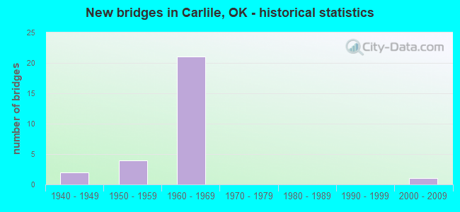
- New bridges - historical statistics
- 21940-1949
- 41950-1959
- 211960-1969
- 12000-2009

- Reconstructed bridges - Historical Statistics
- 11970-1979
- 01980-1989
- 01990-1999
- 12000-2009


- Bridge Condition - Deck
- 15.4%Very good
- 15.4%Good
- 46.2%Satisfactory
- 23.1%Fair

- Bridge Condition - Superstructure
- 7.7%Very good
- 46.2%Good
- 30.8%Satisfactory
- 15.4%Fair

- Bridge Condition - Substructure
- 15.4%Very good
- 15.4%Good
- 53.8%Satisfactory
- 15.4%Fair

- Bridge Condition - Channel
- 50.0%Good
- 38.9%Satisfactory
- 11.1%Fair

- Bridge Condition - Culverts
- 40.0%Good
- 50.0%Satisfactory
- 10.0%Fair
Find on map >> Show street view
Structure Number: 21640-00005, Location: GRAVEL RD-1/8 MI S OF HQ (Lat: 35.447000, Lng: -94.973333), Route carried "on" structure: Federal lands road , Year Built: 1940, Status: Open, Structure Length: 1.13m (3.71ft), Average Daily Traffic: 50 (year 2021), Average Future Daily Traffic: 60 (year 2040), Design Load: H 15, Features Intersected: HORTON SLOUGH, Facility Carried by Structure: AUTO TOUR ROAD
Minimum Vertical Clearance: 30.48m (100.00ft), Kilometerpoint: 1.448, Lanes on structure: 2, Owner: Bureau of Fish and Wildlife, Approaching Roadway Width: 4.9m (16.1ft), Material/Design: Concrete, Design/Construction: Tee Beam, Number Of Spans In Main Unit: 1, Length of Maximum Span: 10.7m (35.1ft), Curb or Sidewalk Widths: Left: 4.0m (13.1ft), Right: 1.2m (3.9ft), Curb-To-Curb Width: 5.3m (17.4ft), Out-to-Out Width: 8.9m (29.2ft)
Condition: Deck: Satisfactory, Superstructure: Satisfactory, Substructure: Satisfactory, Channel: Satisfactory, Operating Rating: 32.7 metric tons, Method Used To Determine Operating Rating: Field evaluation and documented engineering judgment, Inventory Rating: 24.5 metric tons, Method Used To Determine Inventory Rating: Field evaluation and documented engineering judgment, Structural Evaluation: Equal to present minimum criteria, Deck Geometry: High priority of corrective action, Waterway Adequacy: Equal to present minimum criteria, Approach Roadway Alignment: Equal to present minimum criteria, Designated Inspection Frequency: Every 24 months, Underwater Inspection Frequency: Every 60 months, Inspection Date: January 2021, Underwater Inspection Date: April 2018, Deck Structure Type: Concrete Cast-file-Place, Wearing Surface/Protective System: Wearing Surface: Bituminous
Find on map >> Show street view
Structure Number: 21640-00029, Location: GRAVEL RD-1/4 MI N OF HQ (Lat: 35.451167, Lng: -94.973333), Route carried "on" structure: Federal lands road , Year Built: 1940, Status: Open, Structure Length: 0.67m (2.20ft), Average Daily Traffic: 50 (year 2021), Average Future Daily Traffic: 60 (year 2041), Features Intersected: UNNAMED FIELD DRAINAGE, Facility Carried by Structure: ENTRANCE ROAD
Minimum Vertical Clearance: 30.48m (100.00ft), Kilometerpoint: 2.253, Lanes on structure: 2, Owner: Bureau of Fish and Wildlife, Approaching Roadway Width: 5.5m (18.0ft), Material/Design: Concrete, Design/Construction: Culvert, Number Of Spans In Main Unit: 2, Length of Maximum Span: 3.7m (12.1ft), Curb or Sidewalk Widths: Left: 1.3m (4.3ft), Right: 0.4m (1.3ft), Curb-To-Curb Width: 6.3m (20.7ft), Out-to-Out Width: 7.1m (23.3ft)
Condition: Channel: Good, Culverts: Good, Operating Rating: 36.3 metric tons, Method Used To Determine Operating Rating: Field evaluation and documented engineering judgment, Inventory Rating: 32.7 metric tons, Method Used To Determine Inventory Rating: Field evaluation and documented engineering judgment, Structural Evaluation: Better than present minimum criteria, Deck Geometry: Somewhat better than minimum adequacy, Waterway Adequacy: Better than present minimum criteria, Approach Roadway Alignment: Better than present minimum criteria, Designated Inspection Frequency: Every 24 months, Inspection Date: November 2021, Deck Structure Type: Concrete Cast-file-Place, Wearing Surface/Protective System: Wearing Surface: Monolithic Concrete
Find on map >> Show street view
Structure Number: 14283, Location: 2.09 E JCT SH-10 (Lat: 35.500433, Lng: -95.044119), Route carried "on" structure: US 64, Year Built: 1959, Status: Open, Structure Length: 0.99m (3.25ft), Average Daily Traffic: 1,300 (year 2020), Truck Traffic: 15%, Average Future Daily Traffic: 2,080 (year 2040), Design Load: HS 20, Features Intersected: SALT BRANCH CREEK
Minimum Vertical Clearance: 30+ m (98+ ft), Kilometerpoint: 3.364, Lanes on structure: 2, Owner: State Highway Agency, Approaching Roadway Width: 9.8m (32.2ft), Skew: 4 degrees, Material/Design: Concrete, Design/Construction: Culvert, Number Of Spans In Main Unit: 2, Length of Maximum Span: 3.0m (9.8ft)
Condition: Channel: Fair, Culverts: Satisfactory, Operating Rating: 50.5 metric tons, Method Used To Determine Operating Rating: Load Factor (LF), Inventory Rating: 30.3 metric tons, Method Used To Determine Inventory Rating: Load Factor (LF), Structural Evaluation: Equal to present minimum criteria, Waterway Adequacy: Better than present minimum criteria, Approach Roadway Alignment: Equal to present desirable criteria, Length Of Structure Improvement: 0.98m (3.22ft), Designated Inspection Frequency: Every 24 months, Inspection Date: October 2021, Bridge Improvement Cost: $230,000, Roadway Improvement Cost: $380,000, Total Project Cost: $644,000 ( Estimate for 2015)
Find on map >> Show street view
Structure Number: 1431, Location: 0.95 E JCT SH-10 (Lat: 35.506431, Lng: -95.062997), Route carried "on" structure: US 64, Year Built: 1959, Status: Open, Structure Length: 1.41m (4.63ft), Average Daily Traffic: 1,300 (year 2020), Truck Traffic: 15%, Average Future Daily Traffic: 2,080 (year 2040), Design Load: HS 20, Features Intersected: SALT BRANCH CREEK
Minimum Vertical Clearance: 30+ m (98+ ft), Kilometerpoint: 1.529, Lanes on structure: 2, Owner: State Highway Agency, Approaching Roadway Width: 9.8m (32.2ft), Skew: 3 degrees, Material/Design: Concrete, Design/Construction: Culvert, Number Of Spans In Main Unit: 3, Length of Maximum Span: 4.3m (14.1ft)
Condition: Channel: Satisfactory, Culverts: Satisfactory, Operating Rating: 44.5 metric tons, Method Used To Determine Operating Rating: Allowable Stress (AS), Inventory Rating: 32.7 metric tons, Method Used To Determine Inventory Rating: Allowable Stress (AS), Structural Evaluation: Equal to present minimum criteria, Waterway Adequacy: Equal to present minimum criteria, Approach Roadway Alignment: Equal to present desirable criteria, Length Of Structure Improvement: 1.46m (4.79ft), Designated Inspection Frequency: Every 24 months, Inspection Date: October 2021, Bridge Improvement Cost: $230,000, Roadway Improvement Cost: $380,000, Total Project Cost: $644,000 ( Estimate for 2015)
Find on map >> Show street view
Structure Number: 14482, Location: 2.2 MI E MUSKOGEE C/L (Lat: 35.515850, Lng: -95.086272), Route carried "on" structure: State highway 10, Year Built: 1959, Year Reconstructed: 2012, Status: Open, Structure Length: 7.35m (24.11ft), Average Daily Traffic: 2,000 (year 2020), Truck Traffic: 15%, Average Future Daily Traffic: 3,200 (year 2040), Design Load: H 20, Features Intersected: DEEP BRANCH CREEK
Minimum Vertical Clearance: 30+ m (98+ ft), Kilometerpoint: 3.219, Lanes on structure: 2, Owner: State Highway Agency, Approaching Roadway Width: 8.5m (27.9ft), Material/Design: Steel, Design/Construction: Stringer/Multi-beam, Number Of Spans In Main Unit: 4, Length of Maximum Span: 18.3m (60.0ft), Curb-To-Curb Width: 8.5m (27.9ft), Out-to-Out Width: 9.4m (30.8ft)
Condition: Deck: Good, Superstructure: Fair, Substructure: Fair, Channel: Good, Operating Rating: 85.5 metric tons, Method Used To Determine Operating Rating: Load Factor (LF), Inventory Rating: 51.3 metric tons, Method Used To Determine Inventory Rating: Load Factor (LF), Structural Evaluation: Somewhat better than minimum adequacy, Deck Geometry: Somewhat better than minimum adequacy, Waterway Adequacy: Equal to present minimum criteria, Approach Roadway Alignment: Somewhat better than minimum adequacy, Length Of Structure Improvement: 9.93m (32.58ft), Designated Inspection Frequency: Every 24 months, Inspection Date: December 2020, Bridge Improvement Cost: $795,000, Roadway Improvement Cost: $1,312,000, Total Project Cost: $2,227,000 ( Estimate for 2015), Deck Structure Type: Concrete Cast-file-Place, Wearing Surface/Protective System: Wearing Surface: Monolithic Concrete, Deck Protection: Epoxy Coated Reinforcing
Find on map >> Show street view
Structure Number: 1451, Location: 1.9 MI E MUSKOGEE C/L (Lat: 35.515775, Lng: -95.091328), Route carried "on" structure: US 64, Year Built: 1959, Status: Open, Structure Length: 15.94m (52.30ft), Average Daily Traffic: 2,000 (year 2020), Truck Traffic: 15%, Average Future Daily Traffic: 3,200 (year 2040), Design Load: H 20, Features Intersected: ILLINOIS RIVER
Minimum Vertical Clearance: 30+ m (98+ ft), Kilometerpoint: 3.603, Lanes on structure: 2, Owner: State Highway Agency, Approaching Roadway Width: 9.1m (29.9ft), Material/Design: Steel continuous, Design/Construction: Stringer/Multi-beam, Number Of Spans In Main Unit: 4, Number Of Approach Spans: 2, Length of Maximum Span: 30.5m (100.1ft), Curb-To-Curb Width: 8.5m (27.9ft), Out-to-Out Width: 9.4m (30.8ft)
Condition: Deck: Satisfactory, Superstructure: Fair, Substructure: Fair, Channel: Good, Operating Rating: 48.2 metric tons, Method Used To Determine Operating Rating: Load Factor (LF), Inventory Rating: 28.9 metric tons, Method Used To Determine Inventory Rating: Load Factor (LF), Structural Evaluation: Somewhat better than minimum adequacy, Deck Geometry: Somewhat better than minimum adequacy, Waterway Adequacy: Equal to present minimum criteria, Approach Roadway Alignment: Equal to present minimum criteria, Length Of Structure Improvement: 15.94m (52.30ft), Designated Inspection Frequency: Every 24 months, Inspection Date: December 2020, Bridge Improvement Cost: $1,195,000, Roadway Improvement Cost: $1,972,000, Total Project Cost: $3,346,000 ( Estimate for 2015), Deck Structure Type: Concrete Cast-file-Place, Wearing Surface/Protective System: Wearing Surface: Monolithic Concrete, Deck Protection: Epoxy Coated Reinforcing
Find on map >> Show street view
Structure Number: 15129, Location: 0.4 MI S OF I-40 (Lat: 35.483219, Lng: -94.973361), Route carried "on" structure: County highway 6810C, Year Built: 1960, Status: Posted for load, Structure Length: 4.95m (16.24ft), Average Daily Traffic: 500 (year 2020), Truck Traffic: 15%, Average Future Daily Traffic: 720 (year 2040), Design Load: HS 20, Features Intersected: LITTLE VIAN CREEK
Minimum Vertical Clearance: 30+ m (98+ ft), Kilometerpoint: 14.964, Lanes on structure: 2, Owner: County Highway Agency, Approaching Roadway Width: 7.9m (25.9ft), Material/Design: Steel, Design/Construction: Stringer/Multi-beam, Number Of Spans In Main Unit: 3, Length of Maximum Span: 18.3m (60.0ft), Curb-To-Curb Width: 7.3m (24.0ft), Out-to-Out Width: 8.1m (26.6ft)
Condition: Deck: Satisfactory, Superstructure: Good, Substructure: Satisfactory, Channel: Good, Operating Rating: 19.1 metric tons, Method Used To Determine Operating Rating: Load Factor (LF), Inventory Rating: 10.9 metric tons, Method Used To Determine Inventory Rating: Load Factor (LF), Structural Evaluation: Meets minimum limits, Deck Geometry: Meets minimum limits, Waterway Adequacy: Equal to present desirable criteria, Approach Roadway Alignment: Equal to present minimum criteria, Bridge Posting: Required (Relationship of Operating Rating to Maximum Legal Load: 20.0 - 29.9% below), Length Of Structure Improvement: 8.02m (26.31ft), Designated Inspection Frequency: Every 12 months, Inspection Date: June 2021, Bridge Improvement Cost: $410,000, Roadway Improvement Cost: $225,000, Total Project Cost: $636,000 ( Estimate for 2015), Deck Structure Type: Concrete Cast-file-Place, Wearing Surface/Protective System: Wearing Surface: Bituminous
Find on map >> Show street view
Structure Number: 15288, Location: 5.44 E JCT SH-10 (Lat: 35.500422, Lng: -94.984678), Route carried "on" structure: US 64, Year Built: 1961, Status: Open, Structure Length: 1.37m (4.49ft), Average Daily Traffic: 1,300 (year 2020), Truck Traffic: 15%, Average Future Daily Traffic: 2,080 (year 2040), Design Load: HS 20, Features Intersected: GRAVEYARD BRANCH CREEK
Minimum Vertical Clearance: 30+ m (98+ ft), Kilometerpoint: 8.753, Lanes on structure: 2, Owner: State Highway Agency, Approaching Roadway Width: 9.8m (32.2ft), Skew: 4 degrees, Material/Design: Concrete, Design/Construction: Culvert, Number Of Spans In Main Unit: 3, Length of Maximum Span: 3.0m (9.8ft)
Condition: Channel: Satisfactory, Culverts: Fair, Operating Rating: 90.7 metric tons, Method Used To Determine Operating Rating: Load Factor (LF), Inventory Rating: 63.8 metric tons, Method Used To Determine Inventory Rating: Load Factor (LF), Structural Evaluation: Somewhat better than minimum adequacy, Waterway Adequacy: Equal to present minimum criteria, Approach Roadway Alignment: Equal to present desirable criteria, Length Of Structure Improvement: 1.46m (4.79ft), Designated Inspection Frequency: Every 24 months, Inspection Date: October 2021, Bridge Improvement Cost: $230,000, Roadway Improvement Cost: $380,000, Total Project Cost: $644,000 ( Estimate for 2015)
Find on map >> Show street view
Structure Number: 15331, Location: 5.28 E JCT SH-10 (Lat: 35.500350, Lng: -94.987267), Route carried "on" structure: US 64, Year Built: 1961, Status: Open, Structure Length: 4.60m (15.09ft), Average Daily Traffic: 1,300 (year 2020), Truck Traffic: 15%, Average Future Daily Traffic: 2,080 (year 2040), Design Load: HL 93, Features Intersected: VIAN CREEK
Minimum Vertical Clearance: 30+ m (98+ ft), Kilometerpoint: 13.673, Lanes on structure: 2, Owner: State Highway Agency, Approaching Roadway Width: 9.8m (32.2ft), Material/Design: Steel, Design/Construction: Stringer/Multi-beam, Number Of Spans In Main Unit: 3, Length of Maximum Span: 14.0m (45.9ft), Curb or Sidewalk Widths: Left: 0.5m (1.6ft), Right: 0.5m (1.6ft), Curb-To-Curb Width: 9.1m (29.9ft), Out-to-Out Width: 9.8m (32.2ft)
Condition: Deck: Very good, Superstructure: Good, Substructure: Very good, Channel: Satisfactory, Operating Rating: 92.6 metric tons, Method Used To Determine Operating Rating: Load and Resistance Factor (LRFR), Inventory Rating: 71.4 metric tons, Method Used To Determine Inventory Rating: Load and Resistance Factor (LRFR), Structural Evaluation: Better than present minimum criteria, Deck Geometry: Somewhat better than minimum adequacy, Waterway Adequacy: Better than present minimum criteria, Approach Roadway Alignment: Better than present minimum criteria, Length Of Structure Improvement: 7.75m (25.43ft), Designated Inspection Frequency: Every 24 months, Inspection Date: October 2021, Bridge Improvement Cost: $643,000, Roadway Improvement Cost: $1,061,000, Total Project Cost: $1,800,000 ( Estimate for 2015), Deck Structure Type: Concrete Cast-file-Place, Wearing Surface/Protective System: Wearing Surface: Monolithic Concrete
Find on map >> Show street view
Structure Number: 16647, Location: 2.0 MI N OF US 64 (Lat: 35.525647, Lng: -95.079203), Route carried "on" structure: County highway 6804C, Year Built: 1966, Status: Open, Structure Length: 0.70m (2.30ft), Average Daily Traffic: 600 (year 2020), Truck Traffic: 15%, Average Future Daily Traffic: 960 (year 2040), Design Load: HS 20, Features Intersected: CREEK
Minimum Vertical Clearance: 30+ m (98+ ft), Kilometerpoint: 1.448, Lanes on structure: 2, Owner: County Highway Agency, Approaching Roadway Width: 7.3m (24.0ft), Material/Design: Concrete, Design/Construction: Culvert, Number Of Spans In Main Unit: 2, Length of Maximum Span: 3.0m (9.8ft), Curb-To-Curb Width: 7.3m (24.0ft), Out-to-Out Width: 7.9m (25.9ft)
Condition: Channel: Fair, Culverts: Good, Operating Rating: 35.5 metric tons, Method Used To Determine Operating Rating: Load Factor (LF), Inventory Rating: 27.6 metric tons, Method Used To Determine Inventory Rating: Load Factor (LF), Structural Evaluation: Equal to present minimum criteria, Deck Geometry: Meets minimum limits, Waterway Adequacy: Better than present minimum criteria, Approach Roadway Alignment: Better than present minimum criteria, Length Of Structure Improvement: 2.86m (9.38ft), Designated Inspection Frequency: Every 24 months, Inspection Date: June 2021, Bridge Improvement Cost: $100,000, Roadway Improvement Cost: $75,000, Total Project Cost: $225,000 ( Estimate for 2015)
Find on map >> Show street view
Structure Number: 16694, Location: 5.0 MI N OF US 64 (Lat: 35.519469, Lng: -95.079675), Route carried "on" structure: County highway 6804C, Year Built: 1966, Status: Open, Structure Length: 1.28m (4.20ft), Average Daily Traffic: 400 (year 2020), Truck Traffic: 15%, Average Future Daily Traffic: 640 (year 2040), Design Load: HS 20, Features Intersected: DEEP BRUSHY BRANCH, Facility Carried by Structure: MOONSHINE ROAD
Minimum Vertical Clearance: 30+ m (98+ ft), Kilometerpoint: 8.045, Lanes on structure: 2, Owner: County Highway Agency, Approaching Roadway Width: 7.3m (24.0ft), Material/Design: Steel, Design/Construction: Stringer/Multi-beam, Number Of Spans In Main Unit: 1, Length of Maximum Span: 11.3m (37.1ft), Curb-To-Curb Width: 7.3m (24.0ft), Out-to-Out Width: 7.9m (25.9ft)
Condition: Deck: Satisfactory, Superstructure: Satisfactory, Substructure: Satisfactory, Channel: Good, Operating Rating: 37.0 metric tons, Method Used To Determine Operating Rating: Load Factor (LF), Inventory Rating: 22.2 metric tons, Method Used To Determine Inventory Rating: Load Factor (LF), Structural Evaluation: Equal to present minimum criteria, Deck Geometry: Somewhat better than minimum adequacy, Waterway Adequacy: Better than present minimum criteria, Approach Roadway Alignment: Somewhat better than minimum adequacy, Length Of Structure Improvement: 3.93m (12.89ft), Designated Inspection Frequency: Every 24 months, Inspection Date: June 2021, Bridge Improvement Cost: $201,000, Roadway Improvement Cost: $110,000, Total Project Cost: $319,000 ( Estimate for 2015), Deck Structure Type: Concrete Cast-file-Place, Wearing Surface/Protective System: Wearing Surface: Bituminous
Find on map >> Show street view
Structure Number: 16838, Location: 2.58 E MUSKOGEE C/L (Lat: 35.491861, Lng: -95.056061), Route carried "on" structure: Interstate 40, Year Built: 1967, Status: Open, Structure Length: 0.67m (2.20ft), Average Daily Traffic: 8,300 (year 2020), Truck Traffic: 36%, Average Future Daily Traffic: 13,280 (year 2040), Design Load: HS 20, Features Intersected: CO. RD. UNDER
Minimum Vertical Clearance: 30+ m (98+ ft), Kilometerpoint: 4.150, Lanes on structure: 2, Lanes under structure: 2, Base Highway Network: Yes, Owner: State Highway Agency, Approaching Roadway Width: 11.6m (38.1ft), Skew: 12 degrees, Material/Design: Concrete, Design/Construction: Culvert, Number Of Spans In Main Unit: 1, Length of Maximum Span: 6.1m (20.0ft)
Condition: Culverts: Good, Operating Rating: 67.6 metric tons, Method Used To Determine Operating Rating: Load Factor (LF), Inventory Rating: 40.6 metric tons, Method Used To Determine Inventory Rating: Load Factor (LF), Structural Evaluation: Better than present minimum criteria, Underclear: High priority of corrective action, Approach Roadway Alignment: Equal to present desirable criteria, Length Of Structure Improvement: 0.67m (2.20ft), Designated Inspection Frequency: Every 24 months, Inspection Date: October 2021, Bridge Improvement Cost: $230,000, Roadway Improvement Cost: $380,000, Total Project Cost: $644,000 ( Estimate for 2015)
Find on map >> Show street view
Structure Number: 16839, Location: 2.58 E MUSKOGEE C/L (Lat: 35.490994, Lng: -95.055661), Route carried "on" structure: Interstate 40, Year Built: 1967, Status: Open, Structure Length: 0.67m (2.20ft), Average Daily Traffic: 8,200 (year 2020), Truck Traffic: 36%, Average Future Daily Traffic: 13,120 (year 2040), Design Load: HS 20, Features Intersected: CO. RD. UNDER
Minimum Vertical Clearance: 30+ m (98+ ft), Kilometerpoint: 4.150, Lanes on structure: 2, Lanes under structure: 2, Base Highway Network: Yes, Owner: State Highway Agency, Approaching Roadway Width: 11.6m (38.1ft), Skew: 11 degrees, Material/Design: Concrete, Design/Construction: Culvert, Number Of Spans In Main Unit: 1, Length of Maximum Span: 6.1m (20.0ft)
Condition: Culverts: Good, Operating Rating: 67.6 metric tons, Method Used To Determine Operating Rating: Load Factor (LF), Inventory Rating: 40.6 metric tons, Method Used To Determine Inventory Rating: Load Factor (LF), Structural Evaluation: Better than present minimum criteria, Underclear: High priority of corrective action, Approach Roadway Alignment: Equal to present desirable criteria, Length Of Structure Improvement: 0.67m (2.20ft), Designated Inspection Frequency: Every 24 months, Inspection Date: October 2021, Bridge Improvement Cost: $230,000, Roadway Improvement Cost: $380,000, Total Project Cost: $644,000 ( Estimate for 2015)
Find on map >> Show street view
Structure Number: 16901, Location: 4.87 E MUSKOGEE C/L (Lat: 35.491461, Lng: -95.015497), Route carried "on" structure: Interstate 40, Year Built: 1967, Status: Open, Structure Length: 1.55m (5.09ft), Average Daily Traffic: 8,200 (year 2020), Truck Traffic: 36%, Average Future Daily Traffic: 13,120 (year 2040), Design Load: HS 20, Features Intersected: CREEK
Minimum Vertical Clearance: 30+ m (98+ ft), Kilometerpoint: 7.836, Lanes on structure: 2, Base Highway Network: Yes, Owner: State Highway Agency, Approaching Roadway Width: 11.6m (38.1ft), Skew: 13 degrees, Material/Design: Concrete, Design/Construction: Culvert, Number Of Spans In Main Unit: 3, Length of Maximum Span: 4.3m (14.1ft)
Condition: Channel: Satisfactory, Culverts: Satisfactory, Operating Rating: 75.7 metric tons, Method Used To Determine Operating Rating: Load Factor (LF), Inventory Rating: 45.4 metric tons, Method Used To Determine Inventory Rating: Load Factor (LF), Structural Evaluation: Equal to present minimum criteria, Waterway Adequacy: Better than present minimum criteria, Approach Roadway Alignment: Equal to present desirable criteria, Length Of Structure Improvement: 1.49m (4.89ft), Designated Inspection Frequency: Every 24 months, Inspection Date: October 2021, Bridge Improvement Cost: $230,000, Roadway Improvement Cost: $380,000, Total Project Cost: $644,000 ( Estimate for 2015)
Find on map >> Show street view
Structure Number: 16915, Location: 4.87 E MUSKOGEE C/L (Lat: 35.492244, Lng: -95.014989), Route carried "on" structure: Interstate 40, Year Built: 1967, Status: Closed, Structure Length: 1.60m (5.25ft), Average Daily Traffic: 8,300 (year 2020), Truck Traffic: 36%, Average Future Daily Traffic: 13,280 (year 2040), Design Load: HS 20, Features Intersected: CREEK
Minimum Vertical Clearance: 30+ m (98+ ft), Kilometerpoint: 12.611, Lanes on structure: 2, Base Highway Network: Yes, Owner: State Highway Agency, Approaching Roadway Width: 11.6m (38.1ft), Skew: 13 degrees, Material/Design: Concrete, Design/Construction: Culvert, Number Of Spans In Main Unit: 3, Length of Maximum Span: 4.3m (14.1ft)
Condition: Channel: Good, Culverts: Satisfactory, Waterway Adequacy: Better than present minimum criteria, Approach Roadway Alignment: Equal to present desirable criteria, Length Of Structure Improvement: 1.55m (5.09ft), Designated Inspection Frequency: Every 24 months, Inspection Date: October 2021, Bridge Improvement Cost: $230,000, Roadway Improvement Cost: $380,000, Total Project Cost: $644,000 ( Estimate for 2015)
Find on map >> Show street view
Structure Number: 16944, Location: 1.21 E MUSKOGEE C/L (Lat: 35.489064, Lng: -95.079481), Route carried "on" structure: Interstate 40, Year Built: 1967, Status: Open, Structure Length: 3.51m (11.52ft), Average Daily Traffic: 7,950 (year 2020), Truck Traffic: 36%, Average Future Daily Traffic: 12,720 (year 2040), Design Load: HS 20, Features Intersected: S.H. 10 UNDER
Minimum Vertical Clearance: 30+ m (98+ ft), Kilometerpoint: 1.947, Lanes on structure: 2, Lanes under structure: 2, Base Highway Network: Yes, Owner: State Highway Agency, Approaching Roadway Width: 11.6m (38.1ft), Skew: 10 degrees, Material/Design: Concrete continuous, Design/Construction: Slab, Number Of Spans In Main Unit: 3, Length of Maximum Span: 13.4m (44.0ft), Curb or Sidewalk Widths: Left: 0.4m (1.3ft), Right: 0.4m (1.3ft), Curb-To-Curb Width: 11.3m (37.1ft), Out-to-Out Width: 12.1m (39.7ft)
Condition: Deck: Fair, Superstructure: Good, Substructure: Satisfactory, Operating Rating: 50.8 metric tons, Method Used To Determine Operating Rating: Load Factor (LF), Inventory Rating: 30.4 metric tons, Method Used To Determine Inventory Rating: Load Factor (LF), Structural Evaluation: Equal to present minimum criteria, Deck Geometry: Somewhat better than minimum adequacy, Underclear: Somewhat better than minimum adequacy, Approach Roadway Alignment: Equal to present desirable criteria, Length Of Structure Improvement: 5.60m (18.37ft), Designated Inspection Frequency: Every 24 months, Inspection Date: October 2021, Bridge Improvement Cost: $486,000, Roadway Improvement Cost: $802,000, Total Project Cost: $1,361,000 ( Estimate for 2015), Deck Structure Type: Concrete Cast-file-Place, Wearing Surface/Protective System: Wearing Surface: Monolithic Concrete
Find on map >> Show street view
Structure Number: 16945, Location: 1.21 E MUSKOGEE C/L (Lat: 35.490114, Lng: -95.079089), Route carried "on" structure: Interstate 40, Year Built: 1967, Status: Open, Structure Length: 3.51m (11.52ft), Average Daily Traffic: 8,600 (year 2020), Truck Traffic: 36%, Average Future Daily Traffic: 13,760 (year 2040), Design Load: HS 20, Features Intersected: S.H. 10 UNDER
Minimum Vertical Clearance: 30+ m (98+ ft), Kilometerpoint: 1.947, Lanes on structure: 2, Lanes under structure: 2, Base Highway Network: Yes, Owner: State Highway Agency, Approaching Roadway Width: 11.6m (38.1ft), Skew: 10 degrees, Material/Design: Concrete continuous, Design/Construction: Slab, Number Of Spans In Main Unit: 3, Length of Maximum Span: 13.4m (44.0ft), Curb or Sidewalk Widths: Left: 0.4m (1.3ft), Right: 0.4m (1.3ft), Curb-To-Curb Width: 11.3m (37.1ft), Out-to-Out Width: 12.1m (39.7ft)
Condition: Deck: Fair, Superstructure: Good, Substructure: Good, Operating Rating: 50.8 metric tons, Method Used To Determine Operating Rating: Load Factor (LF), Inventory Rating: 30.4 metric tons, Method Used To Determine Inventory Rating: Load Factor (LF), Structural Evaluation: Better than present minimum criteria, Deck Geometry: Somewhat better than minimum adequacy, Underclear: Somewhat better than minimum adequacy, Approach Roadway Alignment: Equal to present desirable criteria, Length Of Structure Improvement: 5.60m (18.37ft), Designated Inspection Frequency: Every 24 months, Inspection Date: October 2021, Bridge Improvement Cost: $486,000, Roadway Improvement Cost: $802,000, Total Project Cost: $1,361,000 ( Estimate for 2015), Deck Structure Type: Concrete Cast-file-Place, Wearing Surface/Protective System: Wearing Surface: Monolithic Concrete
Find on map >> Show street view
Structure Number: 16993, Location: 6.72 E MUSKOGEE C/L (Lat: 35.489908, Lng: -94.983561), Route carried "on" structure: Interstate 40, Year Built: 1967, Status: Closed, Structure Length: 5.55m (18.21ft), Average Daily Traffic: 8,300 (year 2020), Truck Traffic: 36%, Average Future Daily Traffic: 13,280 (year 2040), Design Load: HL 93, Features Intersected: VIAN CREEK
Minimum Vertical Clearance: 30+ m (98+ ft), Kilometerpoint: 17.400, Lanes on structure: 2, Base Highway Network: Yes, Owner: State Highway Agency, Approaching Roadway Width: 11.6m (38.1ft), Skew: 10 degrees, Material/Design: Steel continuous, Design/Construction: Stringer/Multi-beam, Number Of Spans In Main Unit: 3, Length of Maximum Span: 18.3m (60.0ft), Curb or Sidewalk Widths: Left: 0.4m (1.3ft), Right: 0.4m (1.3ft), Curb-To-Curb Width: 11.3m (37.1ft), Out-to-Out Width: 12.1m (39.7ft)
Condition: Deck: Fair, Superstructure: Good, Substructure: Satisfactory, Channel: Good, Deck Geometry: Somewhat better than minimum adequacy, Waterway Adequacy: Equal to present desirable criteria, Approach Roadway Alignment: Equal to present desirable criteria, Length Of Structure Improvement: 8.56m (28.08ft), Designated Inspection Frequency: Every 24 months, Inspection Date: October 2021, Bridge Improvement Cost: $700,000, Roadway Improvement Cost: $1,155,000, Total Project Cost: $1,960,000 ( Estimate for 2015), Deck Structure Type: Concrete Cast-file-Place, Wearing Surface/Protective System: Wearing Surface: Monolithic Concrete
Find on map >> Show street view
Structure Number: 16994, Location: 6.72 E MUSKOGEE C/L (Lat: 35.489294, Lng: -94.984136), Route carried "on" structure: Interstate 40, Year Built: 1967, Year Reconstructed: 2021, Status: Open, Structure Length: 5.55m (18.21ft), Average Daily Traffic: 8,200 (year 2020), Truck Traffic: 36%, Average Future Daily Traffic: 13,120 (year 2040), Design Load: HL 93, Features Intersected: VIAN CREEK
Minimum Vertical Clearance: 30+ m (98+ ft), Kilometerpoint: 17.400, Lanes on structure: 2, Base Highway Network: Yes, Owner: State Highway Agency, Approaching Roadway Width: 11.6m (38.1ft), Skew: 10 degrees, Material/Design: Steel continuous, Design/Construction: Stringer/Multi-beam, Number Of Spans In Main Unit: 3, Length of Maximum Span: 18.3m (60.0ft), Curb or Sidewalk Widths: Left: 0.4m (1.3ft), Right: 0.4m (1.3ft), Curb-To-Curb Width: 11.3m (37.1ft), Out-to-Out Width: 12.1m (39.7ft)
Condition: Deck: Very good, Superstructure: Very good, Substructure: Good, Channel: Good, Operating Rating: 39.1 metric tons, Method Used To Determine Operating Rating: Load and Resistance Factor (LRFR), Inventory Rating: 30.1 metric tons, Method Used To Determine Inventory Rating: Load and Resistance Factor (LRFR), Structural Evaluation: Better than present minimum criteria, Deck Geometry: Somewhat better than minimum adequacy, Waterway Adequacy: Equal to present desirable criteria, Approach Roadway Alignment: Equal to present desirable criteria, Length Of Structure Improvement: 8.56m (28.08ft), Designated Inspection Frequency: Every 24 months, Inspection Date: October 2021, Bridge Improvement Cost: $700,000, Roadway Improvement Cost: $1,155,000, Total Project Cost: $1,960,000 ( Estimate for 2015), Deck Structure Type: Concrete Cast-file-Place, Wearing Surface/Protective System: Wearing Surface: Monolithic Concrete
Find on map >> Show street view
Structure Number: 17005, Location: 4.27 E MUSKOGEE C/L (Lat: 35.490019, Lng: -95.026092), Route carried "on" structure: County highway N4490, Year Built: 1967, Status: Open, Structure Length: 6.52m (21.39ft), Average Daily Traffic: 50 (year 2020), Truck Traffic: 15%, Average Future Daily Traffic: 80 (year 2040), Design Load: H 20, Features Intersected: I-40 UNDER
Minimum Vertical Clearance: 30+ m (98+ ft), Kilometerpoint: 6.870, Lanes on structure: 2, Lanes under structure: 4, Owner: State Highway Agency, Approaching Roadway Width: 8.5m (27.9ft), Skew: 1 degrees, Material/Design: Steel continuous, Design/Construction: Stringer/Multi-beam, Number Of Spans In Main Unit: 2, Number Of Approach Spans: 2, Length of Maximum Span: 22.6m (74.1ft), Curb or Sidewalk Widths: Left: 0.3m (1.0ft), Right: 0.3m (1.0ft), Curb-To-Curb Width: 8.5m (27.9ft), Out-to-Out Width: 9.1m (29.9ft)
Condition: Deck: Satisfactory, Superstructure: Satisfactory, Substructure: Satisfactory, Operating Rating: 55.2 metric tons, Method Used To Determine Operating Rating: Load Factor (LF), Inventory Rating: 33.1 metric tons, Method Used To Determine Inventory Rating: Load Factor (LF), Structural Evaluation: Equal to present minimum criteria, Deck Geometry: Better than present minimum criteria, Underclear: High priority of replacement, Approach Roadway Alignment: Better than present minimum criteria, Length Of Structure Improvement: 8.40m (27.56ft), Designated Inspection Frequency: Every 24 months, Inspection Date: October 2021, Bridge Improvement Cost: $689,000, Roadway Improvement Cost: $1,137,000, Total Project Cost: $1,929,000 ( Estimate for 2015), Deck Structure Type: Concrete Cast-file-Place, Wearing Surface/Protective System: Wearing Surface: Monolithic Concrete
Find on map >> Show street view
Structure Number: 17051, Location: SEQUOYAH-MUSKOGEE CO (Lat: 35.487914, Lng: -95.093903), Route carried "on" structure: Interstate 40, Year Built: 1967, Year Reconstructed: 1983, Status: Open, Structure Length: 60.62m (198.88ft), Average Daily Traffic: 15,900 (year 2020), Truck Traffic: 36%, Average Future Daily Traffic: 25,440 (year 2040), Design Load: HS 20, Features Intersected: ARKANSAS RIVER
Minimum Vertical Clearance: 30+ m (98+ ft), Kilometerpoint: 0.000, Lanes on structure: 4, Base Highway Network: Yes, Owner: State Highway Agency, Approaching Roadway Width: 21.3m (69.9ft), Skew: 20 degrees, Navigation Control: Yes ( Vertical Clearance: 15.8m (51.8ft), Horizontal Clearance: 91.4m (299.9ft)), Material/Design: Steel continuous, Design/Construction: Girder and Floorbeam System, Number Of Spans In Main Unit: 10, Number Of Approach Spans: 3, Length of Maximum Span: 100.6m (330.1ft), Curb or Sidewalk Widths: Left: 0.9m (3.0ft), Right: 0.9m (3.0ft), Curb-To-Curb Width: 18.3m (60.0ft), Out-to-Out Width: 20.9m (68.6ft)
Condition: Deck: Satisfactory, Superstructure: Satisfactory, Substructure: Satisfactory, Channel: Satisfactory, Operating Rating: 49.6 metric tons, Method Used To Determine Operating Rating: Load Factor (LF), Inventory Rating: 29.8 metric tons, Method Used To Determine Inventory Rating: Load Factor (LF), Structural Evaluation: Equal to present minimum criteria, Deck Geometry: Meets minimum limits, Waterway Adequacy: Equal to present desirable criteria, Approach Roadway Alignment: Better than present minimum criteria, Length Of Structure Improvement: 60.62m (198.88ft), Designated Inspection Frequency: Every 24 months, Critical Feature Inspection Frequency: Every 24 months, Underwater Inspection Frequency: Every 60 months, Other Special Inspection Frequency: Every 24 months, Inspection Date: July 2021, Critical Feature Inspection Date: July 2021, Underwater Inspection Date: July 2020, Other Special Inspection Date: August 2020, Bridge Improvement Cost: $20,220,000, Roadway Improvement Cost: $4,500,000, Total Project Cost: $26,119,000 ( Estimate for 2015), Deck Structure Type: Concrete Cast-file-Place, Wearing Surface/Protective System: Wearing Surface: Low Slump Concrete
Find on map >> Show street view
Structure Number: 1743, Location: 1.44 N JCT I-40 (Lat: 35.509953, Lng: -95.079158), Route carried "on" structure: State highway 10, Year Built: 1969, Status: Open, Structure Length: 1.37m (4.49ft), Average Daily Traffic: 1,900 (year 2020), Truck Traffic: 15%, Average Future Daily Traffic: 3,040 (year 2040), Design Load: HS 20, Features Intersected: SALT BRANCH
Minimum Vertical Clearance: 30+ m (98+ ft), Kilometerpoint: 2.317, Lanes on structure: 2, Owner: State Highway Agency, Approaching Roadway Width: 12.2m (40.0ft), Material/Design: Concrete, Design/Construction: Culvert, Number Of Spans In Main Unit: 3, Length of Maximum Span: 5.2m (17.1ft)
Condition: Channel: Satisfactory, Culverts: Satisfactory, Operating Rating: 42.1 metric tons, Method Used To Determine Operating Rating: Load Factor (LF), Inventory Rating: 25.2 metric tons, Method Used To Determine Inventory Rating: Load Factor (LF), Structural Evaluation: Equal to present minimum criteria, Waterway Adequacy: Better than present minimum criteria, Approach Roadway Alignment: Equal to present desirable criteria, Length Of Structure Improvement: 1.43m (4.69ft), Designated Inspection Frequency: Every 24 months, Inspection Date: October 2021, Bridge Improvement Cost: $374,000, Roadway Improvement Cost: $617,000, Total Project Cost: $1,047,000 ( Estimate for 2015)
Find on map >> Show street view
Structure Number: 27602, Location: 4W 2.5S OF SH82/US64 VIAN (Lat: 35.463856, Lng: -95.041606), Route carried "on" structure: County highway E1070, Year Built: 2006, Status: Open, Structure Length: 2.80m (9.19ft), Average Daily Traffic: 100 (year 2020), Truck Traffic: 15%, Average Future Daily Traffic: 160 (year 2040), Design Load: HS 20, Features Intersected: NEGRO CREEK
Minimum Vertical Clearance: 30+ m (98+ ft), Kilometerpoint: 0.161, Lanes on structure: 2, Owner: County Highway Agency, Approaching Roadway Width: 7.9m (25.9ft), Material/Design: Prestressed concrete, Design/Construction: Stringer/Multi-beam, Number Of Spans In Main Unit: 1, Length of Maximum Span: 25.9m (85.0ft), Curb-To-Curb Width: 8.1m (26.6ft), Out-to-Out Width: 8.7m (28.5ft)
Condition: Deck: Good, Superstructure: Good, Substructure: Very good, Channel: Good, Operating Rating: 60.8 metric tons, Method Used To Determine Operating Rating: Allowable Stress (AS), Inventory Rating: 39.0 metric tons, Method Used To Determine Inventory Rating: Allowable Stress (AS), Structural Evaluation: Better than present minimum criteria, Deck Geometry: Equal to present minimum criteria, Waterway Adequacy: Better than present minimum criteria, Approach Roadway Alignment: Equal to present desirable criteria, Length Of Structure Improvement: 3.05m (10.01ft), Designated Inspection Frequency: Every 24 months, Inspection Date: June 2021, Bridge Improvement Cost: $400,000, Roadway Improvement Cost: $660,000, Total Project Cost: $1,120,000 ( Estimate for 2015), Deck Structure Type: Concrete Cast-file-Place, Wearing Surface/Protective System: Wearing Surface: Monolithic Concrete, Deck Protection: Epoxy Coated Reinforcing
Find on map >> Show street view
Structure Number: 16838, Location: 2.58 E MUSKOGEE C/L (Lat: 35.491861, Lng: -95.056061), Route carried "under" structure: County highway N4470, Year Built: 1967, Structure Length: 0. m, Average Daily Traffic: 100 (year 2020), Truck Traffic: 15%, Features Intersected: CO. RD. UNDER, Facility Carried by Structure: I-40
Minimum Vertical Clearance: 4.24m (13.91ft), Kilometerpoint: 4.150, Lanes on structure: 2, Lanes under structure: 2, Material/Design: Concrete, Design/Construction: Culvert, Length of Maximum Span: 6.1m (20.0ft)
Find on map >> Show street view
Structure Number: 16839, Location: 2.58 E MUSKOGEE C/L (Lat: 35.490994, Lng: -95.055661), Route carried "under" structure: County highway N4470, Year Built: 1967, Structure Length: 0. m, Average Daily Traffic: 100 (year 2020), Truck Traffic: 15%, Features Intersected: CO. RD. UNDER, Facility Carried by Structure: I-40
Minimum Vertical Clearance: 4.24m (13.91ft), Kilometerpoint: 4.150, Lanes on structure: 2, Lanes under structure: 2, Material/Design: Concrete, Design/Construction: Culvert, Length of Maximum Span: 6.1m (20.0ft)
Find on map >> Show street view
Structure Number: 16944, Location: 1.21 E MUSKOGEE C/L (Lat: 35.489064, Lng: -95.079481), Route carried "under" structure: State highway 10, Year Built: 1967, Structure Length: 0. m, Average Daily Traffic: 650 (year 2020), Truck Traffic: 15%, Features Intersected: S.H. 10 UNDER, Facility Carried by Structure: I-40
Minimum Vertical Clearance: 5.24m (17.19ft), Kilometerpoint: 0.000, Lanes on structure: 2, Lanes under structure: 2, Material/Design: Concrete continuous, Design/Construction: Slab, Length of Maximum Span: 13.4m (44.0ft)
Find on map >> Show street view
Structure Number: 16945, Location: 1.21 E MUSKOGEE C/L (Lat: 35.490114, Lng: -95.079089), Route carried "under" structure: State highway 10, Year Built: 1967, Structure Length: 0. m, Average Daily Traffic: 650 (year 2020), Truck Traffic: 15%, Features Intersected: S.H. 10 UNDER, Facility Carried by Structure: I-40
Minimum Vertical Clearance: 5.03m (16.50ft), Kilometerpoint: 0.097, Lanes on structure: 2, Lanes under structure: 2, Material/Design: Concrete continuous, Design/Construction: Slab, Length of Maximum Span: 13.4m (44.0ft)
Find on map >> Show street view
Structure Number: 17005, Location: 4.27 E MUSKOGEE C/L (Lat: 35.490019, Lng: -95.026092), Route carried "under" structure: Interstate 40, Year Built: 1967, Structure Length: 0. m, Average Daily Traffic: 16,400 (year 2020), Truck Traffic: 36%, Features Intersected: I-40 UNDER, Facility Carried by Structure: N4490 RD
Minimum Vertical Clearance: 5.28m (17.32ft), Kilometerpoint: 6.870, Lanes on structure: 2, Lanes under structure: 4, Material/Design: Steel continuous, Design/Construction: Stringer/Multi-beam, Length of Maximum Span: 22.6m (74.1ft)