Bridge Statistics for Carmel, New York (NY)
Condition, Traffic, Stress, Structural Evaluation, Project Costs
- National Bridge Inventory (NBI) Statistics
- 10Number of bridges
- 49ft / 14.9mTotal length
- $16,496,000Total costs
- 79,830Total average daily traffic
- 1,954Total average daily truck traffic
- National Bridge Inventory (NBI) Registered Bridges for Carmel
- No street view available for this location
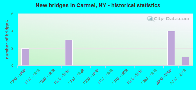
- New bridges - historical statistics
- 21900-1909
- 31930-1939
- 42000-2009
- 12010-2019

- Reconstructed bridges - Historical Statistics
- 11980-1989
- 11990-1999
- 12000-2009


- Bridge Condition - Deck
- 60.0%Satisfactory
- 40.0%Fair

- Bridge Condition - Superstructure
- 14.3%Very good
- 14.3%Good
- 42.9%Satisfactory
- 14.3%Fair
- 14.3%Serious

- Bridge Condition - Substructure
- 14.3%Very good
- 28.6%Good
- 28.6%Satisfactory
- 28.6%Fair

- Bridge Condition - Channel
- 71.4%Good
- 14.3%Fair
- 14.3%Poor
Find on map >> Show street view
Structure Number: 100346, Location: 1.2 MI W JCT US 6 & SH 52 (Lat: 41.411789, Lng: -73.692356), Route carried "on" structure: State highway 6, Year Built: 2004, Status: Open, Structure Length: 3.90m (12.80ft), Average Daily Traffic: 11,311 (year 2020), Truck Traffic: 5%, Average Future Daily Traffic: 11,364 (year 2040), Design Load: HS 25 or greater, Features Intersected: WEST BRANCH CROTON RIVER
Minimum Vertical Clearance: 30+ m (98+ ft), Kilometerpoint: 10.459, Lanes on structure: 2, Base Highway Network: Yes, Owner: State Highway Agency, Approaching Roadway Width: 15.5m (50.9ft), Skew: 23 degrees, Material/Design: Steel, Design/Construction: Stringer/Multi-beam, Number Of Spans In Main Unit: 1, Length of Maximum Span: 37.5m (123.0ft), Curb-To-Curb Width: 15.6m (51.2ft), Out-to-Out Width: 17.0m (55.8ft)
Condition: Deck: Satisfactory, Superstructure: Good, Substructure: Good, Channel: Good, Operating Rating: 71.8 metric tons, Method Used To Determine Operating Rating: Load Factor (LF), Inventory Rating: 43.0 metric tons, Method Used To Determine Inventory Rating: Load Factor (LF), Structural Evaluation: Better than present minimum criteria, Deck Geometry: Superior to present desirable criteria, Waterway Adequacy: Equal to present minimum criteria, Approach Roadway Alignment: Equal to present desirable criteria, Length Of Structure Improvement: 3.90m (12.80ft), Designated Inspection Frequency: Every 24 months, Inspection Date: November 2020, Bridge Improvement Cost: $3,791,000, Roadway Improvement Cost: $2,220,000, Total Project Cost: $6,012,000 ( Estimate for 2021), Deck Structure Type: Concrete Cast-file-Place, Wearing Surface/Protective System: Wearing Surface: Integral Concrete, Deck Protection: Galvanized Reinforcing
Find on map >> Show street view
Structure Number: 100348, Location: 1.4 MI E JCT US 6 & SH 52 (Lat: 41.413278, Lng: -73.658614), Route carried "on" structure: US 6, Year Built: 2009, Status: Open, Structure Length: 0.76m (2.49ft), Average Daily Traffic: 13,786 (year 2020), Truck Traffic: 4%, Average Future Daily Traffic: 13,850 (year 2040), Design Load: HS 25 or greater, Features Intersected: BIKE PATH
Minimum Vertical Clearance: 30+ m (98+ ft), Kilometerpoint: 14.465, Lanes on structure: 2, Base Highway Network: Yes, Owner: State Highway Agency, Approaching Roadway Width: 15.8m (51.8ft), Skew: 25 degrees, Material/Design: Concrete, Design/Construction: Culvert, Number Of Spans In Main Unit: 1, Length of Maximum Span: 6.4m (21.0ft), Curb or Sidewalk Widths: Left: 1.5m (4.9ft), Right: 0.0m
Condition: Culverts: Good, Operating Rating: 77.1 metric tons, Method Used To Determine Operating Rating: Field evaluation and documented engineering judgment, Inventory Rating: 40.8 metric tons, Method Used To Determine Inventory Rating: Field evaluation and documented engineering judgment, Structural Evaluation: Better than present minimum criteria, Approach Roadway Alignment: Equal to present desirable criteria, Length Of Structure Improvement: 0.76m (2.49ft), Designated Inspection Frequency: Every 24 months, Inspection Date: July 2021, Bridge Improvement Cost: $340,000, Roadway Improvement Cost: $199,000, Total Project Cost: $539,000 ( Estimate for 2021)
Find on map >> Show street view
Structure Number: 222374, Location: 1.2 MI NW OF BALDWIN PL (Lat: 41.356986, Lng: -73.772050), Route carried "on" structure: Other road , Year Built: 1930, Year Reconstructed: 1995, Status: Open, Structure Length: 1.65m (5.41ft), Average Daily Traffic: 4,389 (year 2019), Truck Traffic: 3%, Average Future Daily Traffic: 6,145 (year 2039), Design Load: HS 25 or greater, Features Intersected: MUSCOOT RIVER, Facility Carried by Structure: STILLWATER ROAD
Minimum Vertical Clearance: 30+ m (98+ ft), Kilometerpoint: 0.869, Lanes on structure: 2, Owner: County Highway Agency, Approaching Roadway Width: 7.3m (24.0ft), Material/Design: Prestressed concrete, Design/Construction: Box Beam or Girders - Multiple, Number Of Spans In Main Unit: 2, Length of Maximum Span: 7.6m (24.9ft), Curb-To-Curb Width: 7.4m (24.3ft), Out-to-Out Width: 8.6m (28.2ft)
Condition: Deck: Fair, Superstructure: Satisfactory, Substructure: Fair, Channel: Good, Operating Rating: 15.9 metric tons, Method Used To Determine Operating Rating: Load and Resistance Factor Rating (LRFR) rating reported by rating factor(RF) method using HL-93 loadings, Inventory Rating: 12.3 metric tons, Method Used To Determine Inventory Rating: Load and Resistance Factor Rating (LRFR) rating reported by rating factor(RF) method using HL-93 loadings, Structural Evaluation: High priority of corrective action, Deck Geometry: High priority of replacement, Waterway Adequacy: Somewhat better than minimum adequacy, Approach Roadway Alignment: Equal to present minimum criteria, Length Of Structure Improvement: 1.64m (5.38ft), Designated Inspection Frequency: Every 24 months, Inspection Date: April 2021, Bridge Improvement Cost: $306,000, Roadway Improvement Cost: $179,000, Total Project Cost: $485,000 ( Estimate for 2021), Wearing Surface/Protective System: Wearing Surface: Bituminous, Membrane: Other
Find on map >> Show street view
Structure Number: 334555, Location: 2.2 MI E OF MAHOPAC (Lat: 41.388208, Lng: -73.683319), Route carried "on" structure: County highway , Year Built: 1930, Year Reconstructed: 1986, Status: Posted for load, Structure Length: 2.23m (7.32ft), Average Daily Traffic: 3,996 (year 2020), Truck Traffic: 2%, Average Future Daily Traffic: 4,944 (year 2040), Features Intersected: W BR CROTON RIVER, Facility Carried by Structure: DREWVLLE RD CR 36
Minimum Vertical Clearance: 30+ m (98+ ft), Kilometerpoint: 2.623, Lanes on structure: 2, Owner: County Highway Agency, Approaching Roadway Width: 7.0m (23.0ft), Material/Design: Steel, Design/Construction: Girder and Floorbeam System, Number Of Spans In Main Unit: 1, Length of Maximum Span: 20.7m (67.9ft), Curb-To-Curb Width: 7.0m (23.0ft), Out-to-Out Width: 7.5m (24.6ft)
Condition: Deck: Fair, Superstructure: Serious, Substructure: Fair, Channel: Poor, Operating Rating: 47.2 metric tons, Method Used To Determine Operating Rating: Load Testing, Inventory Rating: 28.1 metric tons, Method Used To Determine Inventory Rating: Load Testing, Structural Evaluation: High priority of corrective action, Deck Geometry: High priority of replacement, Waterway Adequacy: Meets minimum limits, Approach Roadway Alignment: Equal to present desirable criteria, Bridge Posting: Required (Relationship of Operating Rating to Maximum Legal Load: > 39.9% below), Length Of Structure Improvement: 2.22m (7.28ft), Designated Inspection Frequency: Every 12 months, Critical Feature Inspection Frequency: Every 12 months, Inspection Date: September 2021, Critical Feature Inspection Date: September 2021, Bridge Improvement Cost: $852,000, Roadway Improvement Cost: $499,000, Total Project Cost: $1,350,000 ( Estimate for 2021), Deck Structure Type: Concrete Cast-file-Place, Wearing Surface/Protective System: Wearing Surface: Integral Concrete, Deck Protection: Epoxy Coated Reinforcing
Find on map >> Show street view
Structure Number: 334556, Location: 2.5 MI E OF MAHOPAC (Lat: 41.388208, Lng: -73.678839), Route carried "on" structure: County highway , Year Built: 1908, Year Reconstructed: 2006, Status: Open, Structure Length: 1.71m (5.61ft), Average Daily Traffic: 1,557 (year 2017), Truck Traffic: 2%, Average Future Daily Traffic: 2,180 (year 2037), Features Intersected: W BRANCH CROTON RIVER, Facility Carried by Structure: W SHORE DR
Minimum Vertical Clearance: 30+ m (98+ ft), Kilometerpoint: 3.186, Lanes on structure: 2, Owner: Local Agency, Approaching Roadway Width: 6.7m (22.0ft), Material/Design: Concrete, Design/Construction: Arch - Deck, Number Of Spans In Main Unit: 1, Length of Maximum Span: 15.2m (49.9ft), Curb-To-Curb Width: 7.4m (24.3ft), Out-to-Out Width: 8.8m (28.9ft)
Condition: Superstructure: Fair, Substructure: Good, Channel: Good, Operating Rating: 41.6 metric tons, Method Used To Determine Operating Rating: Field evaluation and documented engineering judgment, Inventory Rating: 17.3 metric tons, Method Used To Determine Inventory Rating: Field evaluation and documented engineering judgment, Structural Evaluation: Meets minimum limits, Deck Geometry: Meets minimum limits, Waterway Adequacy: Somewhat better than minimum adequacy, Approach Roadway Alignment: Meets minimum limits, Length Of Structure Improvement: 1.70m (5.58ft), Designated Inspection Frequency: Every 24 months, Inspection Date: August 2020, Bridge Improvement Cost: $788,000, Roadway Improvement Cost: $461,000, Total Project Cost: $1,250,000 ( Estimate for 2021), Wearing Surface/Protective System: Wearing Surface: Bituminous
Find on map >> Show street view
Structure Number: 334557, Location: 0.7 MI NW OF CROTON FALLS (Lat: 41.355453, Lng: -73.671350), Route carried "on" structure: County highway , Year Built: 1908, Status: Open, Structure Length: 2.53m (8.30ft), Average Daily Traffic: 7,002 (year 2015), Truck Traffic: 4%, Average Future Daily Traffic: 8,663 (year 2040), Features Intersected: W BRANCH CROTON RIVER, Facility Carried by Structure: CROTN FL RD CR 34
Minimum Vertical Clearance: 30+ m (98+ ft), Kilometerpoint: 6.243, Lanes on structure: 2, Owner: Local Agency, Approaching Roadway Width: 6.1m (20.0ft), Material/Design: Concrete, Design/Construction: Arch - Deck, Number Of Spans In Main Unit: 1, Length of Maximum Span: 24.0m (78.7ft), Curb-To-Curb Width: 7.3m (24.0ft), Out-to-Out Width: 8.2m (26.9ft)
Condition: Deck: Satisfactory, Superstructure: Satisfactory, Substructure: Satisfactory, Channel: Fair, Inventory Rating: 54.4 metric tons, Method Used To Determine Inventory Rating: Allowable Stress (AS), Structural Evaluation: Equal to present minimum criteria, Deck Geometry: High priority of replacement, Waterway Adequacy: Meets minimum limits, Approach Roadway Alignment: Better than present minimum criteria, Length Of Structure Improvement: 2.52m (8.27ft), Designated Inspection Frequency: Every 24 months, Inspection Date: August 2020, Bridge Improvement Cost: $2,224,000, Roadway Improvement Cost: $1,302,000, Total Project Cost: $3,526,000 ( Estimate for 2021), Wearing Surface/Protective System: Wearing Surface: Bituminous
Find on map >> Show street view
Structure Number: 334559, Location: 1.4 MI E OF CARMEL (Lat: 41.434458, Lng: -73.653744), Route carried "on" structure: County highway , Year Built: 2006, Status: Open, Structure Length: 1.16m (3.81ft), Average Daily Traffic: 7,949 (year 2018), Truck Traffic: 4%, Average Future Daily Traffic: 9,656 (year 2040), Design Load: HS 25 or greater, Features Intersected: MID BR CROTON RVR, Facility Carried by Structure: FAIR ST
Minimum Vertical Clearance: 30+ m (98+ ft), Kilometerpoint: 2.269, Lanes on structure: 2, Owner: County Highway Agency, Approaching Roadway Width: 10.4m (34.1ft), Material/Design: Concrete, Design/Construction: Frame, Number Of Spans In Main Unit: 1, Length of Maximum Span: 11.0m (36.1ft), Curb-To-Curb Width: 12.8m (42.0ft), Out-to-Out Width: 17.7m (58.1ft)
Condition: Superstructure: Very good, Substructure: Very good, Channel: Good, Inventory Rating: 72.6 metric tons, Method Used To Determine Inventory Rating: Load Factor (LF), Structural Evaluation: Equal to present desirable criteria, Deck Geometry: Somewhat better than minimum adequacy, Waterway Adequacy: Somewhat better than minimum adequacy, Approach Roadway Alignment: Somewhat better than minimum adequacy, Length Of Structure Improvement: 1.15m (3.77ft), Designated Inspection Frequency: Every 24 months, Inspection Date: September 2021, Bridge Improvement Cost: $945,000, Roadway Improvement Cost: $553,000, Total Project Cost: $1,498,000 ( Estimate for 2021)
Find on map >> Show street view
Structure Number: 5502319, Location: 1.1 MI NE OF TOMPKINS CRN (Lat: 41.408283, Lng: -73.786750), Route carried "on" structure: State highway 987G, Year Built: 1932, Status: Open, Structure Length: 0.98m (3.22ft), Average Daily Traffic: 29,830 (year 2020), Average Future Daily Traffic: 42,081 (year 2040), Features Intersected: PEEKSKLL HOLLW CK
Minimum Vertical Clearance: 30+ m (98+ ft), Kilometerpoint: 8.302, Lanes on structure: 4, Base Highway Network: Yes, Owner: State Highway Agency, Approaching Roadway Width: 13.7m (44.9ft), Skew: 32 degrees, Material/Design: Concrete, Design/Construction: Frame, Number Of Spans In Main Unit: 1, Length of Maximum Span: 7.0m (23.0ft), Curb-To-Curb Width: 13.7m (44.9ft), Out-to-Out Width: 14.7m (48.2ft)
Condition: Deck: Satisfactory, Superstructure: Satisfactory, Substructure: Satisfactory, Channel: Good, Operating Rating: 74.7 metric tons, Method Used To Determine Operating Rating: Field evaluation and documented engineering judgment, Inventory Rating: 32.7 metric tons, Method Used To Determine Inventory Rating: Field evaluation and documented engineering judgment, Structural Evaluation: Equal to present minimum criteria, Deck Geometry: High priority of replacement, Waterway Adequacy: Meets minimum limits, Approach Roadway Alignment: Equal to present desirable criteria, Length Of Structure Improvement: 0.97m (3.18ft), Designated Inspection Frequency: Every 24 months, Inspection Date: July 2020, Bridge Improvement Cost: $1,158,000, Roadway Improvement Cost: $678,000, Total Project Cost: $1,836,000 ( Estimate for 2021), Wearing Surface/Protective System: Wearing Surface: Bituminous
Find on map >> Show street view
Structure Number: 227094, Location: 0.66 MI S JCT Rt.6 & CR 4 (Lat: 41.418928, Lng: -73.673931), Route carried "under" structure: State highway , Year Built: 2013, Structure Length: 0. m, Features Intersected: Rt. 6, Facility Carried by Structure: PUTNAM BIKEWAY II
Minimum Vertical Clearance: 6.05m (19.85ft), Kilometerpoint: 0.000, Lanes under structure: 2, Material/Design: Steel, Design/Construction: Truss - Thru, Length of Maximum Span: 24.0m (78.7ft)
Find on map >> Show street view
Structure Number: 336969, Location: .5 MI NE JCT US 6 & CR 34 (Lat: 41.393764, Lng: -73.698789), Route carried "under" structure: County highway , Year Built: 2005, Structure Length: 0. m, Average Daily Traffic: 10 (year 2021), Features Intersected: DREWVILLE RD-CR36, Facility Carried by Structure: PUTNAM CO BIKEWAY
Minimum Vertical Clearance: 9.00m (29.53ft), Kilometerpoint: 0.000, Lanes under structure: 2, Material/Design: Steel, Design/Construction: Truss - Deck, Length of Maximum Span: 60.0m (196.9ft)