Bridge Statistics for Carrollton, Mississippi (MS)
Condition, Traffic, Stress, Structural Evaluation, Project Costs
- National Bridge Inventory (NBI) Statistics
- 12Number of bridges
- 95ft / 28.9mTotal length
- $407,432,000Total costs
- 15,640Total average daily traffic
- 2,979Total average daily truck traffic
- 16,610Total future (year 2034) average daily traffic
- National Bridge Inventory (NBI) Registered Bridges for Carrollton
- No street view available for this location
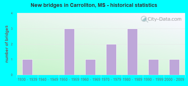
- New bridges - historical statistics
- 11930-1939
- 31950-1959
- 11960-1969
- 21970-1979
- 31980-1989
- 11990-1999
- 12000-2009


- Bridge Condition - Deck
- 28.6%Good
- 71.4%Satisfactory

- Bridge Condition - Superstructure
- 14.3%Very good
- 42.9%Good
- 28.6%Satisfactory
- 14.3%Fair

- Bridge Condition - Substructure
- 28.6%Good
- 57.1%Satisfactory
- 14.3%Fair

- Bridge Condition - Channel
- 41.7%Good
- 33.3%Satisfactory
- 16.7%Fair
- 8.3%Poor

- Bridge Condition - Culverts
- 60.0%Good
- 20.0%Satisfactory
- 20.0%Fair
Find on map >> Show street view
Structure Number: 21000820080780A, Location: 0.7 MI W SR 17 (Lat: 33.499211, Lng: -89.935267), Route carried "on" structure: US 82, Year Built: 1937, Status: Open, Structure Length: 0.70m (2.30ft), Average Daily Traffic: 3,500 (year 2020), Truck Traffic: 21%, Average Future Daily Traffic: 3,700 (year 2040), Design Load: H 15, Features Intersected: STREAM
Minimum Vertical Clearance: 30+ m (98+ ft), Kilometerpoint: 14.017, Lanes on structure: 2, Base Highway Network: Yes (Inventory Route: 8, Subroute: 1), Owner: State Highway Agency, Approaching Roadway Width: 10.4m (34.1ft), Skew: 4 degrees, Material/Design: Concrete, Design/Construction: Culvert, Number Of Spans In Main Unit: 1, Length of Maximum Span: 4.9m (16.1ft)
Condition: Channel: Poor, Culverts: Fair, Operating Rating: 40.6 metric tons, Method Used To Determine Operating Rating: Load Factor (LF), Inventory Rating: 24.3 metric tons, Method Used To Determine Inventory Rating: Load Factor (LF), Structural Evaluation: Somewhat better than minimum adequacy, Waterway Adequacy: Equal to present minimum criteria, Approach Roadway Alignment: Equal to present desirable criteria, Length Of Structure Improvement: 0.70m (2.30ft), Designated Inspection Frequency: Every 24 months, Inspection Date: January 2021, Bridge Improvement Cost: $27,000,000, Roadway Improvement Cost: $115,000,000, Total Project Cost: $165,000,000
Find on map >> Show street view
Structure Number: 21000820080780B, Location: 0.7 MI W SR 17 (Lat: 33.498733, Lng: -89.935953), Route carried "on" structure: US 82, Year Built: 1980, Status: Open, Structure Length: 1.10m (3.61ft), Average Daily Traffic: 3,500 (year 2020), Truck Traffic: 21%, Average Future Daily Traffic: 3,700 (year 2040), Design Load: HS 20, Features Intersected: STREAM
Minimum Vertical Clearance: 30+ m (98+ ft), Kilometerpoint: 15.810, Lanes on structure: 2, Base Highway Network: Yes (Inventory Route: 8, Subroute: 1), Owner: State Highway Agency, Approaching Roadway Width: 13.4m (44.0ft), Skew: 3 degrees, Material/Design: Concrete, Design/Construction: Culvert, Number Of Spans In Main Unit: 2, Length of Maximum Span: 4.3m (14.1ft)
Condition: Channel: Satisfactory, Culverts: Good, Structural Evaluation: Better than present minimum criteria, Waterway Adequacy: Equal to present desirable criteria, Approach Roadway Alignment: Equal to present desirable criteria, Designated Inspection Frequency: Every 24 months, Inspection Date: January 2021
Find on map >> Show street view
Structure Number: 21000820080822A, Location: 4.7 MI W MONTGOMERY CL (Lat: 33.492525, Lng: -89.864400), Route carried "on" structure: US 82, Year Built: 1984, Status: Open, Structure Length: 1.34m (4.40ft), Average Daily Traffic: 2,800 (year 2020), Truck Traffic: 20%, Average Future Daily Traffic: 3,000 (year 2040), Design Load: HS 20, Features Intersected: LITTLE SAND CREEK
Minimum Vertical Clearance: 30+ m (98+ ft), Kilometerpoint: 7.390, Lanes on structure: 2, Base Highway Network: Yes (Inventory Route: 8, Subroute: 1), Owner: State Highway Agency, Approaching Roadway Width: 13.4m (44.0ft), Material/Design: Concrete, Design/Construction: Culvert, Number Of Spans In Main Unit: 2, Length of Maximum Span: 6.1m (20.0ft)
Condition: Channel: Good, Culverts: Good, Operating Rating: 43.2 metric tons, Method Used To Determine Operating Rating: Load Factor (LF), Inventory Rating: 26.1 metric tons, Method Used To Determine Inventory Rating: Load Factor (LF), Structural Evaluation: Equal to present minimum criteria, Waterway Adequacy: Equal to present desirable criteria, Approach Roadway Alignment: Equal to present desirable criteria, Designated Inspection Frequency: Every 24 months, Inspection Date: January 2021
Find on map >> Show street view
Structure Number: 21000820080822B, Location: 4.7 MI W MONTGOMERY CL (Lat: 33.491972, Lng: -89.864503), Route carried "on" structure: US 82, Year Built: 1980, Status: Open, Structure Length: 1.34m (4.40ft), Average Daily Traffic: 2,800 (year 2020), Truck Traffic: 20%, Average Future Daily Traffic: 3,000 (year 2040), Design Load: HS 20, Features Intersected: LITTLE SAND CREEK
Minimum Vertical Clearance: 30+ m (98+ ft), Kilometerpoint: 22.494, Lanes on structure: 3, Base Highway Network: Yes (Inventory Route: 8, Subroute: 1), Owner: State Highway Agency, Approaching Roadway Width: 13.4m (44.0ft), Material/Design: Concrete, Design/Construction: Culvert, Number Of Spans In Main Unit: 2, Length of Maximum Span: 6.1m (20.0ft)
Condition: Channel: Good, Culverts: Good, Structural Evaluation: Better than present minimum criteria, Waterway Adequacy: Equal to present desirable criteria, Approach Roadway Alignment: Equal to present desirable criteria, Designated Inspection Frequency: Every 24 months, Inspection Date: January 2021
Find on map >> Show street view
Structure Number: 31000170080664, Location: 3.6 MI S US 82 (Lat: 33.461756, Lng: -89.956372), Route carried "on" structure: State highway 17, Year Built: 1957, Status: Open, Structure Length: 8.53m (27.99ft), Average Daily Traffic: 1,000 (year 2020), Truck Traffic: 14%, Average Future Daily Traffic: 1,000 (year 2040), Design Load: HS 15, Features Intersected: PALUSHA CREEK
Minimum Vertical Clearance: 30+ m (98+ ft), Kilometerpoint: 20.584, Lanes on structure: 2, Base Highway Network: Yes (Inventory Route: 1, Subroute: 1), Owner: State Highway Agency, Approaching Roadway Width: 7.9m (25.9ft), Material/Design: Concrete continuous, Design/Construction: Box Beam or Girders - Single/Spread, Number Of Spans In Main Unit: 3, Number Of Approach Spans: 2, Length of Maximum Span: 27.4m (89.9ft), Curb or Sidewalk Widths: Left: 0.5m (1.6ft), Right: 0.5m (1.6ft), Curb-To-Curb Width: 7.9m (25.9ft), Out-to-Out Width: 8.5m (27.9ft)
Condition: Deck: Good, Superstructure: Good, Substructure: Good, Channel: Satisfactory, Operating Rating: 52.5 metric tons, Method Used To Determine Operating Rating: Load Factor (LF), Inventory Rating: 31.4 metric tons, Method Used To Determine Inventory Rating: Load Factor (LF), Structural Evaluation: Better than present minimum criteria, Deck Geometry: Somewhat better than minimum adequacy, Waterway Adequacy: Equal to present minimum criteria, Approach Roadway Alignment: Equal to present desirable criteria, Length Of Structure Improvement: 8.53m (27.99ft), Designated Inspection Frequency: Every 24 months, Inspection Date: January 2022, Bridge Improvement Cost: $190,000,000, Roadway Improvement Cost: $26,000,000, Total Project Cost: $240,000,000, Deck Structure Type: Concrete Cast-file-Place, Wearing Surface/Protective System: Wearing Surface: Bituminous
Find on map >> Show street view
Structure Number: 3100035008201, Location: 3.6 MI N US 82 (Lat: 33.525925, Lng: -89.949958), Route carried "on" structure: State highway 35, Year Built: 1958, Status: Open, Structure Length: 0.94m (3.08ft), Average Daily Traffic: 1,700 (year 2020), Truck Traffic: 14%, Average Future Daily Traffic: 1,700 (year 2040), Design Load: HS 15, Features Intersected: BILLUPS BRANCH
Minimum Vertical Clearance: 30+ m (98+ ft), Kilometerpoint: 35.867, Lanes on structure: 2, Base Highway Network: Yes (Inventory Route: 3, Subroute: 2), Owner: State Highway Agency, Approaching Roadway Width: 9.8m (32.2ft), Material/Design: Concrete, Design/Construction: Culvert, Number Of Spans In Main Unit: 2, Length of Maximum Span: 4.3m (14.1ft)
Condition: Channel: Fair, Culverts: Satisfactory, Operating Rating: 34.2 metric tons, Method Used To Determine Operating Rating: Allowable Stress (AS), Inventory Rating: 20.5 metric tons, Method Used To Determine Inventory Rating: Allowable Stress (AS), Structural Evaluation: Somewhat better than minimum adequacy, Waterway Adequacy: Equal to present minimum criteria, Approach Roadway Alignment: Better than present minimum criteria, Designated Inspection Frequency: Every 24 months, Inspection Date: March 2021
Find on map >> Show street view
Structure Number: SA0800000000114, Location: SEC 13 T19N R 3E (Lat: 33.504694, Lng: -89.935722), Route carried "on" structure: City street 137, Year Built: 2006, Status: Posted for load, Structure Length: 1.84m (6.04ft), Average Daily Traffic: 120 (year 2020), Truck Traffic: 8%, Average Future Daily Traffic: 180 (year 2042), Design Load: H 10, Features Intersected: BCH OF BIG SAND CK, Facility Carried by Structure: CO RD 316
Minimum Vertical Clearance: 30+ m (98+ ft), Kilometerpoint: 1.609, Lanes on structure: 2, Owner: County Highway Agency, Approaching Roadway Width: 4.9m (16.1ft), Material/Design: Wood or Timber, Design/Construction: Stringer/Multi-beam, Number Of Spans In Main Unit: 4, Length of Maximum Span: 5.6m (18.4ft), Curb-To-Curb Width: 7.2m (23.6ft), Out-to-Out Width: 7.3m (24.0ft)
Condition: Deck: Satisfactory, Superstructure: Satisfactory, Substructure: Satisfactory, Channel: Good, Operating Rating: 17.2 metric tons, Method Used To Determine Operating Rating: Allowable Stress (AS), Inventory Rating: 12.7 metric tons, Method Used To Determine Inventory Rating: Allowable Stress (AS), Structural Evaluation: Meets minimum limits, Deck Geometry: Meets minimum limits, Waterway Adequacy: Equal to present desirable criteria, Approach Roadway Alignment: Equal to present desirable criteria, Bridge Posting: Required (Relationship of Operating Rating to Maximum Legal Load: > 39.9% below), Length Of Structure Improvement: 2.56m (8.40ft), Designated Inspection Frequency: Every 12 months, Inspection Date: September 2021, Bridge Improvement Cost: $227,000, Roadway Improvement Cost: $182,000, Total Project Cost: $409,000 ( Estimate for 2021), Deck Structure Type: Wood or Timber, Wearing Surface/Protective System: Wearing Surface: Gravel
Find on map >> Show street view
Structure Number: SA0800000000119, Location: SEC 18 T19N R 4E B (Lat: 33.504889, Lng: -89.915250), Route carried "on" structure: City street 318, Year Built: 1971, Status: Posted for load, Structure Length: 1.16m (3.81ft), Average Daily Traffic: 60 (year 2020), Average Future Daily Traffic: 90 (year 2042), Design Load: H 15, Features Intersected: BCH OF TANYARD CREEK, Facility Carried by Structure: CO RD 72
Minimum Vertical Clearance: 30+ m (98+ ft), Kilometerpoint: 0.450, Lanes on structure: 2, Owner: City or Municipal Highway Agency, Approaching Roadway Width: 5.2m (17.1ft), Material/Design: Concrete, Design/Construction: Channel Beam, Number Of Spans In Main Unit: 2, Length of Maximum Span: 5.8m (19.0ft), Curb or Sidewalk Widths: Left: 0.2m (0.7ft), Right: 0.2m (0.7ft), Curb-To-Curb Width: 6.0m (19.7ft), Out-to-Out Width: 6.5m (21.3ft)
Condition: Deck: Satisfactory, Superstructure: Fair, Substructure: Satisfactory, Channel: Good, Operating Rating: 6.4 metric tons, Method Used To Determine Operating Rating: Allowable Stress (AS), Inventory Rating: 0.3 metric tons, Method Used To Determine Inventory Rating: Allowable Stress (AS), Structural Evaluation: High priority of replacement, Deck Geometry: Meets minimum limits, Waterway Adequacy: Equal to present minimum criteria, Approach Roadway Alignment: Equal to present desirable criteria, Bridge Posting: Required (Relationship of Operating Rating to Maximum Legal Load: > 39.9% below), Length Of Structure Improvement: 1.83m (6.00ft), Designated Inspection Frequency: Every 12 months, Inspection Date: September 2021, Bridge Improvement Cost: $163,000, Roadway Improvement Cost: $131,000, Total Project Cost: $294,000 ( Estimate for 2021), Deck Structure Type: Concrete Precast Panels
Find on map >> Show street view
Structure Number: SA0800000000121, Location: SEC 20 T19N R 4E (Lat: 33.502472, Lng: -89.896889), Route carried "on" structure: County highway 72, Year Built: 1960, Year Reconstructed: 2019, Status: Posted for load, Structure Length: 2.39m (7.84ft), Average Daily Traffic: 30 (year 2020), Truck Traffic: 8%, Average Future Daily Traffic: 45 (year 2042), Design Load: H 10, Features Intersected: BCH OF LITTLE SAND CK
Minimum Vertical Clearance: 30+ m (98+ ft), Kilometerpoint: 5.793, Lanes on structure: 1, Owner: County Highway Agency, Approaching Roadway Width: 4.3m (14.1ft), Material/Design: Wood or Timber, Design/Construction: Stringer/Multi-beam, Number Of Spans In Main Unit: 5, Length of Maximum Span: 6.9m (22.6ft), Curb-To-Curb Width: 4.9m (16.1ft), Out-to-Out Width: 4.9m (16.1ft)
Condition: Deck: Good, Superstructure: Good, Substructure: Satisfactory, Channel: Satisfactory, Operating Rating: 32.1 metric tons, Method Used To Determine Operating Rating: Allowable Stress (AS), Inventory Rating: 23.5 metric tons, Method Used To Determine Inventory Rating: Allowable Stress (AS), Structural Evaluation: Equal to present minimum criteria, Deck Geometry: High priority of corrective action, Waterway Adequacy: Better than present minimum criteria, Approach Roadway Alignment: Equal to present minimum criteria, Bridge Posting: Required (Relationship of Operating Rating to Maximum Legal Load: 10.0 - 19.9% below), Length Of Structure Improvement: 3.25m (10.66ft), Designated Inspection Frequency: Every 12 months, Inspection Date: September 2021, Bridge Improvement Cost: $288,000, Roadway Improvement Cost: $231,000, Total Project Cost: $519,000 ( Estimate for 2021), Deck Structure Type: Wood or Timber
Find on map >> Show street view
Structure Number: SA0800000000125, Location: SEC 31 T19N R 4E B (Lat: 33.464917, Lng: -89.919889), Route carried "on" structure: County highway 1752, Year Built: 1954, Status: Posted for load, Structure Length: 4.27m (14.01ft), Average Daily Traffic: 40 (year 2021), Average Future Daily Traffic: 60 (year 2043), Design Load: H 15, Features Intersected: BCH OF PELUCIA CREEK, Facility Carried by Structure: CO RD 211
Minimum Vertical Clearance: 30+ m (98+ ft), Kilometerpoint: 16.576, Lanes on structure: 2, Owner: County Highway Agency, Approaching Roadway Width: 7.3m (24.0ft), Material/Design: Steel, Design/Construction: Stringer/Multi-beam, Number Of Spans In Main Unit: 1, Number Of Approach Spans: 2, Length of Maximum Span: 18.3m (60.0ft), Curb or Sidewalk Widths: Left: 0.3m (1.0ft), Right: 0.3m (1.0ft), Curb-To-Curb Width: 6.7m (22.0ft), Out-to-Out Width: 7.4m (24.3ft)
Condition: Deck: Satisfactory, Superstructure: Satisfactory, Substructure: Satisfactory, Channel: Satisfactory, Operating Rating: 29.4 metric tons, Method Used To Determine Operating Rating: Load Factor (LF), Inventory Rating: 17.7 metric tons, Method Used To Determine Inventory Rating: Load Factor (LF), Structural Evaluation: Somewhat better than minimum adequacy, Deck Geometry: Somewhat better than minimum adequacy, Waterway Adequacy: Equal to present desirable criteria, Approach Roadway Alignment: Equal to present desirable criteria, Bridge Posting: Required (Relationship of Operating Rating to Maximum Legal Load: 20.0 - 29.9% below), Length Of Structure Improvement: 5.24m (17.19ft), Designated Inspection Frequency: Every 12 months, Inspection Date: November 2021, Bridge Improvement Cost: $465,000, Roadway Improvement Cost: $372,000, Total Project Cost: $837,000 ( Estimate for 2021), Deck Structure Type: Concrete Cast-file-Place
Find on map >> Show street view
Structure Number: SA0800000000126, Location: SEC 32 T19N R 4E B (Lat: 33.472583, Lng: -89.898528), Route carried "on" structure: County highway 53, Year Built: 1976, Status: Open, Structure Length: 3.66m (12.01ft), Average Daily Traffic: 60 (year 2014), Average Future Daily Traffic: 90 (year 2034), Design Load: HS 15, Features Intersected: PELUCIA CREEK
Minimum Vertical Clearance: 30+ m (98+ ft), Kilometerpoint: 2.253, Lanes on structure: 2, Owner: County Highway Agency, Approaching Roadway Width: 6.1m (20.0ft), Material/Design: Prestressed concrete, Design/Construction: Stringer/Multi-beam, Number Of Spans In Main Unit: 3, Length of Maximum Span: 12.2m (40.0ft), Curb or Sidewalk Widths: Left: 0.4m (1.3ft), Right: 0.4m (1.3ft), Curb-To-Curb Width: 7.9m (25.9ft), Out-to-Out Width: 8.7m (28.5ft)
Condition: Deck: Satisfactory, Superstructure: Very good, Substructure: Good, Channel: Good, Operating Rating: 60.3 metric tons, Method Used To Determine Operating Rating: Load Factor (LF) rating reported by rating factor (RF) method using MS18 loading, Inventory Rating: 27.2 metric tons, Method Used To Determine Inventory Rating: Load Factor (LF) rating reported by rating factor (RF) method using MS18 loading, Structural Evaluation: Equal to present minimum criteria, Deck Geometry: Equal to present minimum criteria, Waterway Adequacy: Equal to present desirable criteria, Approach Roadway Alignment: Equal to present minimum criteria, Designated Inspection Frequency: Every 24 months, Inspection Date: November 2019, Deck Structure Type: Concrete Cast-file-Place, Wearing Surface/Protective System: Wearing Surface: Monolithic Concrete
Find on map >> Show street view
Structure Number: SA0800000000185, Location: SEC 21 T19N R 4E (Lat: 33.502500, Lng: -89.873667), Route carried "on" structure: County highway 72, Year Built: 1999, Status: Posted for load, Structure Length: 1.65m (5.41ft), Average Daily Traffic: 30 (year 2020), Average Future Daily Traffic: 45 (year 2042), Design Load: H 10, Features Intersected: BCH OF LITTLE SAND CK, Facility Carried by Structure: NORWOOD RD
Minimum Vertical Clearance: 30+ m (98+ ft), Kilometerpoint: 1.601, Lanes on structure: 2, Owner: County Highway Agency, Approaching Roadway Width: 4.6m (15.1ft), Material/Design: Wood or Timber, Design/Construction: Stringer/Multi-beam, Number Of Spans In Main Unit: 4, Length of Maximum Span: 4.8m (15.7ft), Curb-To-Curb Width: 7.4m (24.3ft), Out-to-Out Width: 7.4m (24.3ft)
Condition: Deck: Satisfactory, Superstructure: Good, Substructure: Fair, Channel: Fair, Operating Rating: 33.6 metric tons, Method Used To Determine Operating Rating: Allowable Stress (AS), Inventory Rating: 23.6 metric tons, Method Used To Determine Inventory Rating: Allowable Stress (AS), Structural Evaluation: Somewhat better than minimum adequacy, Deck Geometry: Equal to present minimum criteria, Waterway Adequacy: Better than present minimum criteria, Approach Roadway Alignment: High priority of corrective action, Bridge Posting: Required (Relationship of Operating Rating to Maximum Legal Load: 20.0 - 29.9% below), Length Of Structure Improvement: 2.34m (7.68ft), Designated Inspection Frequency: Every 12 months, Inspection Date: September 2021, Bridge Improvement Cost: $207,000, Roadway Improvement Cost: $166,000, Total Project Cost: $373,000 ( Estimate for 2021), Deck Structure Type: Wood or Timber