Bridge Statistics for Carthage, Indiana (IN)
Condition, Traffic, Stress, Structural Evaluation, Project Costs
- National Bridge Inventory (NBI) Statistics
- 20Number of bridges
- 187ft / 56.6mTotal length
- $1,276,000Total costs
- 9,712Total average daily traffic
- 516Total average daily truck traffic
- 13,875Total future (year 2038) average daily traffic
- National Bridge Inventory (NBI) Registered Bridges for Carthage
- No street view available for this location
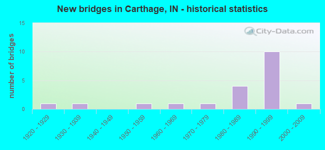
- New bridges - historical statistics
- 11920-1929
- 11930-1939
- 11950-1959
- 11960-1969
- 11970-1979
- 41980-1989
- 101990-1999
- 12000-2009

- Reconstructed bridges - Historical Statistics
- 21980-1989
- 01990-1999
- 12000-2009

- Bridge Condition - Deck
- 5.3%Very good
- 52.6%Good
- 31.6%Satisfactory
- 10.5%Fair

- Bridge Condition - Superstructure
- 5.3%Very good
- 57.9%Good
- 21.1%Satisfactory
- 15.8%Fair

- Bridge Condition - Substructure
- 5.3%Very good
- 42.1%Good
- 31.6%Satisfactory
- 21.1%Fair

- Bridge Condition - Channel
- 35.0%Good
- 40.0%Satisfactory
- 20.0%Fair
- 5.0%Poor
Find on map >> Show street view
Structure Number: 300053, Location: 00.04 N OF 750 N (Lat: 39.720389, Lng: -85.632767), Route carried "on" structure: County highway 73, Year Built: 1990, Status: Open, Structure Length: 4.69m (15.39ft), Average Daily Traffic: 650 (year 2018), Truck Traffic: 3%, Average Future Daily Traffic: 1,220 (year 2038), Design Load: HS 20, Features Intersected: SIX MILE CREEK, Facility Carried by Structure: CR 900E
Minimum Vertical Clearance: 30+ m (98+ ft), Kilometerpoint: 0.000, Lanes on structure: 2, Owner: County Highway Agency, Approaching Roadway Width: 6.1m (20.0ft), Skew: 1 degrees, Material/Design: Prestressed concrete continuous, Design/Construction: Stringer/Multi-beam, Number Of Spans In Main Unit: 3, Length of Maximum Span: 16.2m (53.1ft), Curb-To-Curb Width: 8.5m (27.9ft), Out-to-Out Width: 9.4m (30.8ft)
Condition: Deck: Good, Superstructure: Good, Substructure: Good, Channel: Good, Operating Rating: 32.7 metric tons, Method Used To Determine Operating Rating: Field evaluation and documented engineering judgment, Inventory Rating: 32.7 metric tons, Method Used To Determine Inventory Rating: Field evaluation and documented engineering judgment, Structural Evaluation: Better than present minimum criteria, Deck Geometry: Somewhat better than minimum adequacy, Waterway Adequacy: Equal to present desirable criteria, Approach Roadway Alignment: Equal to present minimum criteria, Designated Inspection Frequency: Every 24 months, Inspection Date: June 2020, Deck Structure Type: Concrete Cast-file-Place, Wearing Surface/Protective System: Wearing Surface: Monolithic Concrete, Deck Protection: Epoxy Coated Reinforcing
Find on map >> Show street view
Structure Number: 3000535, Location: 00.26 N OF 400 S (Lat: 39.731111, Lng: -85.632706), Route carried "on" structure: County highway 73, Year Built: 1990, Status: Open, Structure Length: 4.69m (15.39ft), Average Daily Traffic: 420 (year 2018), Truck Traffic: 3%, Average Future Daily Traffic: 790 (year 2038), Design Load: HS 20, Features Intersected: SIX MILE CREEK, Facility Carried by Structure: CR 900E
Minimum Vertical Clearance: 30+ m (98+ ft), Kilometerpoint: 0.000, Lanes on structure: 2, Owner: County Highway Agency, Approaching Roadway Width: 5.5m (18.0ft), Skew: 2 degrees, Material/Design: Prestressed concrete continuous, Design/Construction: Box Beam or Girders - Single/Spread, Number Of Spans In Main Unit: 3, Length of Maximum Span: 15.4m (50.5ft), Curb-To-Curb Width: 7.9m (25.9ft), Out-to-Out Width: 8.8m (28.9ft)
Condition: Deck: Good, Superstructure: Good, Substructure: Good, Channel: Satisfactory, Operating Rating: 32.7 metric tons, Method Used To Determine Operating Rating: Field evaluation and documented engineering judgment, Inventory Rating: 32.7 metric tons, Method Used To Determine Inventory Rating: Field evaluation and documented engineering judgment, Structural Evaluation: Better than present minimum criteria, Deck Geometry: Somewhat better than minimum adequacy, Waterway Adequacy: Equal to present desirable criteria, Approach Roadway Alignment: Equal to present minimum criteria, Designated Inspection Frequency: Every 24 months, Inspection Date: June 2020, Deck Structure Type: Concrete Cast-file-Place, Wearing Surface/Protective System: Wearing Surface: Monolithic Concrete, Deck Protection: Epoxy Coated Reinforcing
Find on map >> Show street view
Structure Number: 300054, Location: 00.11 N OF E 300 S (Lat: 39.743661, Lng: -85.632661), Route carried "on" structure: County highway 73, Year Built: 2000, Status: Open, Structure Length: 4.27m (14.01ft), Average Daily Traffic: 420 (year 2018), Truck Traffic: 3%, Average Future Daily Traffic: 790 (year 2038), Design Load: HS 20, Features Intersected: SIX MILE CREEK, Facility Carried by Structure: CR 900E
Minimum Vertical Clearance: 30+ m (98+ ft), Kilometerpoint: 0.000, Lanes on structure: 2, Owner: County Highway Agency, Approaching Roadway Width: 6.1m (20.0ft), Material/Design: Prestressed concrete continuous, Design/Construction: Box Beam or Girders - Single/Spread, Number Of Spans In Main Unit: 3, Length of Maximum Span: 14.6m (47.9ft), Curb-To-Curb Width: 7.8m (25.6ft), Out-to-Out Width: 8.7m (28.5ft)
Condition: Deck: Very good, Superstructure: Very good, Substructure: Very good, Channel: Fair, Operating Rating: 32.7 metric tons, Method Used To Determine Operating Rating: Field evaluation and documented engineering judgment, Inventory Rating: 32.7 metric tons, Method Used To Determine Inventory Rating: Field evaluation and documented engineering judgment, Structural Evaluation: Equal to present desirable criteria, Deck Geometry: Meets minimum limits, Waterway Adequacy: Equal to present minimum criteria, Approach Roadway Alignment: Equal to present minimum criteria, Designated Inspection Frequency: Every 24 months, Inspection Date: June 2020, Deck Structure Type: Concrete Cast-file-Place, Wearing Surface/Protective System: Wearing Surface: Monolithic Concrete, Deck Protection: Epoxy Coated Reinforcing
Find on map >> Show street view
Structure Number: 7000001, Location: 00.01 W OF CR 900 W (Lat: 39.771119, Lng: -85.614281), Route carried "on" structure: County highway 67, Year Built: 1992, Status: Posted for load, Structure Length: 2.89m (9.48ft), Average Daily Traffic: 672 (year 2019), Truck Traffic: 5%, Average Future Daily Traffic: 900 (year 2039), Features Intersected: SIX MILE CREEK, Facility Carried by Structure: CR 1100N
Minimum Vertical Clearance: 30+ m (98+ ft), Kilometerpoint: 0.000, Lanes on structure: 2, Owner: County Highway Agency, Approaching Roadway Width: 5.2m (17.1ft), Material/Design: Steel, Number Of Spans In Main Unit: 3, Number Of Approach Spans: 1, Length of Maximum Span: 18.0m (59.1ft), Curb-To-Curb Width: 6.4m (21.0ft), Out-to-Out Width: 6.9m (22.6ft)
Condition: Deck: Fair, Superstructure: Fair, Substructure: Fair, Channel: Satisfactory, Operating Rating: 13.6 metric tons, Method Used To Determine Operating Rating: Field evaluation and documented engineering judgment, Inventory Rating: 13.6 metric tons, Method Used To Determine Inventory Rating: Field evaluation and documented engineering judgment, Structural Evaluation: Meets minimum limits, Deck Geometry: High priority of corrective action, Waterway Adequacy: Equal to present minimum criteria, Approach Roadway Alignment: High priority of corrective action, Bridge Posting: Required (Relationship of Operating Rating to Maximum Legal Load: > 39.9% below), Length Of Structure Improvement: 3.81m (12.50ft), Designated Inspection Frequency: Every 24 months, Other Special Inspection Frequency: Every 48 months, Inspection Date: May 2021, Other Special Inspection Date: May 2021, Bridge Improvement Cost: $530,000, Roadway Improvement Cost: $481,000, Total Project Cost: $1,276,000 ( Estimate for 2021), Deck Structure Type: Steel plate, Wearing Surface/Protective System: Wearing Surface: Bituminous
Find on map >> Show street view
Structure Number: 7000002, Location: 00.05 W OF CR 900 W (Lat: 39.756569, Lng: -85.614361), Route carried "on" structure: County highway 1000, Year Built: 1930, Status: Open, Structure Length: 0.70m (2.30ft), Average Daily Traffic: 675 (year 2019), Truck Traffic: 5%, Average Future Daily Traffic: 900 (year 2039), Features Intersected: MILES CREEK
Minimum Vertical Clearance: 30+ m (98+ ft), Kilometerpoint: 0.000, Lanes on structure: 2, Owner: County Highway Agency, Approaching Roadway Width: 5.2m (17.1ft), Material/Design: Concrete, Design/Construction: Slab, Number Of Spans In Main Unit: 1, Length of Maximum Span: 6.1m (20.0ft), Curb-To-Curb Width: 5.5m (18.0ft), Out-to-Out Width: 6.0m (19.7ft)
Condition: Deck: Fair, Superstructure: Fair, Substructure: Fair, Channel: Fair, Operating Rating: 32.7 metric tons, Method Used To Determine Operating Rating: Field evaluation and documented engineering judgment, Inventory Rating: 24.5 metric tons, Method Used To Determine Inventory Rating: Field evaluation and documented engineering judgment, Structural Evaluation: Somewhat better than minimum adequacy, Deck Geometry: High priority of replacement, Waterway Adequacy: Equal to present minimum criteria, Approach Roadway Alignment: Equal to present minimum criteria, Designated Inspection Frequency: Every 24 months, Inspection Date: April 2021, Deck Structure Type: Concrete Cast-file-Place, Wearing Surface/Protective System: Wearing Surface: Bituminous
Find on map >> Show street view
Structure Number: 7000003, Location: 00.27 E OF CR 1000 W (Lat: 39.756589, Lng: -85.627511), Route carried "on" structure: County highway 1000, Year Built: 1920, Year Reconstructed: 2000, Status: Open, Structure Length: 3.41m (11.19ft), Average Daily Traffic: 250 (year 2019), Truck Traffic: 5%, Average Future Daily Traffic: 325 (year 2039), Features Intersected: SIX MILE CREEK
Minimum Vertical Clearance: 30+ m (98+ ft), Kilometerpoint: 0.000, Lanes on structure: 2, Owner: County Highway Agency, Approaching Roadway Width: 4.9m (16.1ft), Material/Design: Concrete continuous, Design/Construction: Arch - Deck, Number Of Spans In Main Unit: 2, Length of Maximum Span: 15.3m (50.2ft), Curb-To-Curb Width: 7.3m (24.0ft), Out-to-Out Width: 7.5m (24.6ft)
Condition: Deck: Good, Superstructure: Fair, Substructure: Fair, Channel: Poor, Operating Rating: 32.7 metric tons, Method Used To Determine Operating Rating: Field evaluation and documented engineering judgment, Inventory Rating: 18.2 metric tons, Method Used To Determine Inventory Rating: Field evaluation and documented engineering judgment, Structural Evaluation: Somewhat better than minimum adequacy, Deck Geometry: Somewhat better than minimum adequacy, Waterway Adequacy: Equal to present desirable criteria, Approach Roadway Alignment: Equal to present desirable criteria, Designated Inspection Frequency: Every 24 months, Inspection Date: April 2021, Deck Structure Type: Concrete Cast-file-Place, Wearing Surface/Protective System: Wearing Surface: Monolithic Concrete
Find on map >> Show street view
Structure Number: 7000004, Location: 00.01 S OF CR 1100 N (Lat: 39.771150, Lng: -85.613650), Route carried "on" structure: County highway 13, Year Built: 1980, Year Reconstructed: 1987, Status: Posted for load, Structure Length: 0.91m (2.99ft), Average Daily Traffic: 675 (year 2019), Truck Traffic: 5%, Average Future Daily Traffic: 900 (year 2039), Design Load: HS 20, Features Intersected: CHARLOTTES BROOK, Facility Carried by Structure: CR 900W
Minimum Vertical Clearance: 30+ m (98+ ft), Kilometerpoint: 0.000, Lanes on structure: 2, Owner: County Highway Agency, Approaching Roadway Width: 6.7m (22.0ft), Material/Design: Prestressed concrete, Design/Construction: Box Beam or Girders - Multiple, Number Of Spans In Main Unit: 1, Length of Maximum Span: 8.8m (28.9ft), Curb-To-Curb Width: 8.5m (27.9ft), Out-to-Out Width: 8.6m (28.2ft)
Condition: Deck: Satisfactory, Superstructure: Satisfactory, Substructure: Good, Channel: Good, Operating Rating: 48.2 metric tons, Method Used To Determine Operating Rating: Load Factor (LF), Inventory Rating: 28.9 metric tons, Method Used To Determine Inventory Rating: Load Factor (LF), Structural Evaluation: Equal to present minimum criteria, Deck Geometry: Somewhat better than minimum adequacy, Waterway Adequacy: Equal to present minimum criteria, Approach Roadway Alignment: High priority of corrective action, Designated Inspection Frequency: Every 24 months, Inspection Date: April 2021, Deck Structure Type: Concrete Precast Panels, Wearing Surface/Protective System: Wearing Surface: Bituminous
Find on map >> Show street view
Structure Number: 7000005, Location: 00.20 S OF CR 700 N (Lat: 39.708519, Lng: -85.615950), Route carried "on" structure: County highway 13, Year Built: 1993, Status: Open, Structure Length: 8.08m (26.51ft), Average Daily Traffic: 100 (year 2019), Truck Traffic: 5%, Average Future Daily Traffic: 150 (year 2039), Design Load: HS 20, Features Intersected: BIG BLUE RIVER, Facility Carried by Structure: CR 925W
Minimum Vertical Clearance: 30+ m (98+ ft), Kilometerpoint: 0.000, Lanes on structure: 2, Owner: County Highway Agency, Approaching Roadway Width: 6.4m (21.0ft), Skew: 1 degrees, Material/Design: Prestressed concrete continuous, Design/Construction: Stringer/Multi-beam, Number Of Spans In Main Unit: 3, Length of Maximum Span: 28.3m (92.8ft), Curb-To-Curb Width: 7.3m (24.0ft), Out-to-Out Width: 8.2m (26.9ft)
Condition: Deck: Good, Superstructure: Good, Substructure: Good, Channel: Good, Operating Rating: 82.0 metric tons, Method Used To Determine Operating Rating: Load Factor (LF), Inventory Rating: 43.6 metric tons, Method Used To Determine Inventory Rating: Load Factor (LF), Structural Evaluation: Better than present minimum criteria, Deck Geometry: Equal to present minimum criteria, Waterway Adequacy: Equal to present desirable criteria, Approach Roadway Alignment: Equal to present desirable criteria, Designated Inspection Frequency: Every 24 months, Inspection Date: May 2021, Deck Structure Type: Concrete Cast-file-Place, Wearing Surface/Protective System: Wearing Surface: Monolithic Concrete, Deck Protection: Epoxy Coated Reinforcing
Find on map >> Show street view
Structure Number: 7000006, Location: 00.15 E OF CR 1000 W (Lat: 39.727500, Lng: -85.629700), Route carried "on" structure: County highway 62, Year Built: 1989, Status: Open, Structure Length: 4.68m (15.35ft), Average Daily Traffic: 275 (year 2019), Truck Traffic: 5%, Average Future Daily Traffic: 375 (year 2039), Design Load: HS 20, Features Intersected: SIX MILE CREEK, Facility Carried by Structure: CR 800N
Minimum Vertical Clearance: 30+ m (98+ ft), Kilometerpoint: 0.000, Lanes on structure: 2, Owner: County Highway Agency, Approaching Roadway Width: 5.8m (19.0ft), Skew: 1 degrees, Material/Design: Prestressed concrete continuous, Design/Construction: Stringer/Multi-beam, Number Of Spans In Main Unit: 3, Length of Maximum Span: 21.8m (71.5ft), Curb-To-Curb Width: 7.3m (24.0ft), Out-to-Out Width: 7.3m (24.0ft)
Condition: Deck: Good, Superstructure: Good, Substructure: Good, Channel: Good, Operating Rating: 40.8 metric tons, Method Used To Determine Operating Rating: Field evaluation and documented engineering judgment, Inventory Rating: 32.7 metric tons, Method Used To Determine Inventory Rating: Field evaluation and documented engineering judgment, Structural Evaluation: Better than present minimum criteria, Deck Geometry: Somewhat better than minimum adequacy, Waterway Adequacy: Equal to present desirable criteria, Approach Roadway Alignment: Equal to present desirable criteria, Designated Inspection Frequency: Every 24 months, Inspection Date: April 2021, Deck Structure Type: Concrete Precast Panels, Wearing Surface/Protective System: Wearing Surface: Monolithic Concrete, Deck Protection: Epoxy Coated Reinforcing
Find on map >> Show street view
Structure Number: 7000007, Location: 00.64 E OF CR 800 W (Lat: 39.727850, Lng: -85.583161), Route carried "on" structure: County highway 62, Year Built: 1984, Status: Open, Structure Length: 6.24m (20.47ft), Average Daily Traffic: 775 (year 2019), Truck Traffic: 5%, Average Future Daily Traffic: 1,050 (year 2039), Design Load: HS 20, Features Intersected: BIG BLUE RIVER, Facility Carried by Structure: CR 800N
Minimum Vertical Clearance: 30+ m (98+ ft), Kilometerpoint: 0.000, Lanes on structure: 2, Owner: County Highway Agency, Approaching Roadway Width: 5.8m (19.0ft), Material/Design: Prestressed concrete continuous, Design/Construction: Stringer/Multi-beam, Number Of Spans In Main Unit: 3, Length of Maximum Span: 20.4m (66.9ft), Curb-To-Curb Width: 7.9m (25.9ft), Out-to-Out Width: 8.7m (28.5ft)
Condition: Deck: Satisfactory, Superstructure: Good, Substructure: Good, Channel: Satisfactory, Operating Rating: 51.9 metric tons, Method Used To Determine Operating Rating: Load and Resistance Factor (LRFR), Inventory Rating: 45.0 metric tons, Method Used To Determine Inventory Rating: Load and Resistance Factor (LRFR), Structural Evaluation: Better than present minimum criteria, Deck Geometry: Somewhat better than minimum adequacy, Waterway Adequacy: Equal to present desirable criteria, Approach Roadway Alignment: Equal to present desirable criteria, Designated Inspection Frequency: Every 24 months, Inspection Date: April 2021, Deck Structure Type: Concrete Cast-file-Place, Wearing Surface/Protective System: Wearing Surface: Monolithic Concrete, Deck Protection: Epoxy Coated Reinforcing
Find on map >> Show street view
Structure Number: 7000008, Location: 00.03 E OF GOOSE ROAD (Lat: 39.757061, Lng: -85.572450), Route carried "on" structure: County highway 1000, Year Built: 1969, Status: Open, Structure Length: 1.16m (3.81ft), Average Daily Traffic: 250 (year 2019), Truck Traffic: 5%, Average Future Daily Traffic: 300 (year 2039), Design Load: HS 20, Features Intersected: GOOSE CREEK
Minimum Vertical Clearance: 30+ m (98+ ft), Kilometerpoint: 0.000, Lanes on structure: 2, Owner: County Highway Agency, Approaching Roadway Width: 4.3m (14.1ft), Material/Design: Concrete, Design/Construction: Channel Beam, Number Of Spans In Main Unit: 1, Length of Maximum Span: 11.3m (37.1ft), Curb-To-Curb Width: 6.8m (22.3ft), Out-to-Out Width: 6.9m (22.6ft)
Condition: Deck: Satisfactory, Superstructure: Satisfactory, Substructure: Satisfactory, Channel: Satisfactory, Operating Rating: 67.6 metric tons, Method Used To Determine Operating Rating: Load Factor (LF), Inventory Rating: 40.5 metric tons, Method Used To Determine Inventory Rating: Load Factor (LF), Structural Evaluation: Equal to present minimum criteria, Deck Geometry: Meets minimum limits, Waterway Adequacy: Better than present minimum criteria, Approach Roadway Alignment: Equal to present desirable criteria, Designated Inspection Frequency: Every 24 months, Inspection Date: May 2021, Deck Structure Type: Concrete Precast Panels, Wearing Surface/Protective System: Wearing Surface: Bituminous
Find on map >> Show street view
Structure Number: 700001, Location: 00.01 E OF GOOSE ROAD (Lat: 39.743131, Lng: -85.575881), Route carried "on" structure: County highway 278, Year Built: 1950, Year Reconstructed: 1994, Status: Open, Structure Length: 8.15m (26.74ft), Average Daily Traffic: 1,000 (year 2019), Truck Traffic: 5%, Average Future Daily Traffic: 1,450 (year 2039), Design Load: HS 15, Features Intersected: BIG BLUE RIVER, Facility Carried by Structure: CR 900N
Minimum Vertical Clearance: 30+ m (98+ ft), Kilometerpoint: 0.000, Lanes on structure: 2, Owner: County Highway Agency, Approaching Roadway Width: 6.1m (20.0ft), Material/Design: Steel continuous, Design/Construction: Stringer/Multi-beam, Number Of Spans In Main Unit: 4, Length of Maximum Span: 21.9m (71.9ft), Curb or Sidewalk Widths: Left: 0.3m (1.0ft), Right: 0.3m (1.0ft), Curb-To-Curb Width: 7.3m (24.0ft), Out-to-Out Width: 7.9m (25.9ft)
Condition: Deck: Satisfactory, Superstructure: Satisfactory, Substructure: Satisfactory, Channel: Satisfactory, Operating Rating: 58.7 metric tons, Method Used To Determine Operating Rating: Load Factor (LF), Inventory Rating: 35.1 metric tons, Method Used To Determine Inventory Rating: Load Factor (LF), Structural Evaluation: Equal to present minimum criteria, Deck Geometry: Meets minimum limits, Waterway Adequacy: Equal to present desirable criteria, Approach Roadway Alignment: Equal to present minimum criteria, Designated Inspection Frequency: Every 24 months, Inspection Date: April 2021, Deck Structure Type: Concrete Cast-file-Place, Wearing Surface/Protective System: Wearing Surface: Monolithic Concrete
Find on map >> Show street view
Structure Number: 7000109, Location: 00.40 S OF CR 600 N (Lat: 39.692439, Lng: -85.576339), Route carried "on" structure: County highway 23, Year Built: 1999, Status: Open, Structure Length: 0.72m (2.36ft), Average Daily Traffic: 700 (year 2019), Truck Traffic: 10%, Average Future Daily Traffic: 950 (year 2039), Design Load: HS 20, Features Intersected: BEAVER MEADOW CREEK, Facility Carried by Structure: CR 700W
Minimum Vertical Clearance: 30+ m (98+ ft), Kilometerpoint: 0.000, Lanes on structure: 2, Owner: County Highway Agency, Approaching Roadway Width: 7.9m (25.9ft), Material/Design: Concrete, Design/Construction: Culvert, Number Of Spans In Main Unit: 2, Length of Maximum Span: 3.0m (9.8ft), Curb-To-Curb Width: 11.3m (37.1ft), Out-to-Out Width: 16.8m (55.1ft)
Condition: Channel: Good, Culverts: Good, Operating Rating: 40.8 metric tons, Method Used To Determine Operating Rating: Field evaluation and documented engineering judgment, Inventory Rating: 32.7 metric tons, Method Used To Determine Inventory Rating: Field evaluation and documented engineering judgment, Structural Evaluation: Better than present minimum criteria, Deck Geometry: Better than present minimum criteria, Waterway Adequacy: Better than present minimum criteria, Approach Roadway Alignment: Equal to present desirable criteria, Designated Inspection Frequency: Every 24 months, Inspection Date: May 2021, Wearing Surface/Protective System: Wearing Surface: Bituminous
Find on map >> Show street view
Structure Number: 7000191, Location: 00.10 S OF HENLEY STREET (Lat: 39.735761, Lng: -85.570039), Route carried "on" structure: City street , Year Built: 1991, Status: Open, Structure Length: 0.76m (2.49ft), Average Daily Traffic: 250 (year 2019), Truck Traffic: 5%, Average Future Daily Traffic: 325 (year 2039), Design Load: HS 20, Features Intersected: CARTHAGE CREEK, Facility Carried by Structure: WALNUT STREET
Minimum Vertical Clearance: 30+ m (98+ ft), Kilometerpoint: 0.000, Lanes on structure: 2, Owner: County Highway Agency, Approaching Roadway Width: 5.2m (17.1ft), Material/Design: Prestressed concrete, Design/Construction: Box Beam or Girders - Multiple, Number Of Spans In Main Unit: 1, Length of Maximum Span: 7.2m (23.6ft), Curb-To-Curb Width: 6.0m (19.7ft), Out-to-Out Width: 6.1m (20.0ft)
Condition: Deck: Satisfactory, Superstructure: Satisfactory, Substructure: Fair, Channel: Fair, Operating Rating: 66.4 metric tons, Method Used To Determine Operating Rating: Load Factor (LF), Inventory Rating: 39.7 metric tons, Method Used To Determine Inventory Rating: Load Factor (LF), Structural Evaluation: Somewhat better than minimum adequacy, Deck Geometry: High priority of corrective action, Waterway Adequacy: Better than present minimum criteria, Approach Roadway Alignment: Equal to present desirable criteria, Designated Inspection Frequency: Every 24 months, Inspection Date: April 2021, Deck Structure Type: Concrete Precast Panels, Wearing Surface/Protective System: Wearing Surface: Bituminous
Find on map >> Show street view
Structure Number: 7000192, Location: 00.10 S OF HENLEY ST (Lat: 39.735731, Lng: -85.571189), Route carried "on" structure: City street , Year Built: 1991, Status: Open, Structure Length: 0.75m (2.46ft), Average Daily Traffic: 300 (year 2019), Truck Traffic: 5%, Average Future Daily Traffic: 375 (year 2039), Design Load: HS 20, Features Intersected: CARTHAGE CREEK, Facility Carried by Structure: EAST STREET
Minimum Vertical Clearance: 30+ m (98+ ft), Kilometerpoint: 0.000, Lanes on structure: 2, Owner: County Highway Agency, Approaching Roadway Width: 5.5m (18.0ft), Material/Design: Prestressed concrete, Design/Construction: Box Beam or Girders - Multiple, Number Of Spans In Main Unit: 1, Length of Maximum Span: 7.0m (23.0ft), Curb-To-Curb Width: 5.9m (19.4ft), Out-to-Out Width: 6.1m (20.0ft)
Condition: Deck: Good, Superstructure: Good, Substructure: Satisfactory, Channel: Satisfactory, Operating Rating: 69.0 metric tons, Method Used To Determine Operating Rating: Load Factor (LF), Inventory Rating: 41.3 metric tons, Method Used To Determine Inventory Rating: Load Factor (LF), Structural Evaluation: Equal to present minimum criteria, Deck Geometry: High priority of corrective action, Waterway Adequacy: Better than present minimum criteria, Approach Roadway Alignment: Equal to present desirable criteria, Designated Inspection Frequency: Every 24 months, Inspection Date: April 2021, Deck Structure Type: Concrete Precast Panels, Wearing Surface/Protective System: Wearing Surface: Bituminous
Find on map >> Show street view
Structure Number: 7000193, Location: 00.01 W OF MAIN STREET (Lat: 39.736550, Lng: -85.572689), Route carried "on" structure: City street , Year Built: 1991, Status: Open, Structure Length: 0.92m (3.02ft), Average Daily Traffic: 250 (year 2019), Truck Traffic: 5%, Average Future Daily Traffic: 325 (year 2039), Design Load: HS 20, Features Intersected: CARTHAGE CREEK, Facility Carried by Structure: HENLEY STREET
Minimum Vertical Clearance: 30+ m (98+ ft), Kilometerpoint: 0.000, Lanes on structure: 2, Owner: County Highway Agency, Approaching Roadway Width: 7.3m (24.0ft), Material/Design: Prestressed concrete, Design/Construction: Box Beam or Girders - Multiple, Number Of Spans In Main Unit: 1, Length of Maximum Span: 8.6m (28.2ft), Curb-To-Curb Width: 7.2m (23.6ft), Out-to-Out Width: 7.3m (24.0ft)
Condition: Deck: Good, Superstructure: Good, Substructure: Satisfactory, Channel: Satisfactory, Operating Rating: 51.5 metric tons, Method Used To Determine Operating Rating: Load Factor (LF), Inventory Rating: 30.8 metric tons, Method Used To Determine Inventory Rating: Load Factor (LF), Structural Evaluation: Equal to present minimum criteria, Deck Geometry: Meets minimum limits, Waterway Adequacy: Better than present minimum criteria, Approach Roadway Alignment: Equal to present desirable criteria, Designated Inspection Frequency: Every 24 months, Inspection Date: April 2021, Deck Structure Type: Concrete Precast Panels, Wearing Surface/Protective System: Wearing Surface: Bituminous
Find on map >> Show street view
Structure Number: 7000194, Location: 00.10 N OF HENLEY STREET (Lat: 39.737550, Lng: -85.573381), Route carried "on" structure: City street , Year Built: 1991, Status: Open, Structure Length: 0.82m (2.69ft), Average Daily Traffic: 250 (year 2019), Truck Traffic: 5%, Average Future Daily Traffic: 325 (year 2039), Design Load: HS 20, Features Intersected: CARTHAGE CREEK, Facility Carried by Structure: MARKET STREET
Minimum Vertical Clearance: 30+ m (98+ ft), Kilometerpoint: 0.000, Lanes on structure: 2, Owner: County Highway Agency, Approaching Roadway Width: 5.8m (19.0ft), Skew: 2 degrees, Material/Design: Prestressed concrete, Design/Construction: Box Beam or Girders - Multiple, Number Of Spans In Main Unit: 1, Length of Maximum Span: 7.8m (25.6ft), Curb-To-Curb Width: 5.9m (19.4ft), Out-to-Out Width: 6.1m (20.0ft)
Condition: Deck: Good, Superstructure: Good, Substructure: Good, Channel: Good, Operating Rating: 66.8 metric tons, Method Used To Determine Operating Rating: Load Factor (LF), Inventory Rating: 40.0 metric tons, Method Used To Determine Inventory Rating: Load Factor (LF), Structural Evaluation: Better than present minimum criteria, Deck Geometry: High priority of corrective action, Waterway Adequacy: Better than present minimum criteria, Approach Roadway Alignment: Equal to present desirable criteria, Designated Inspection Frequency: Every 24 months, Inspection Date: April 2021, Deck Structure Type: Concrete Precast Panels, Wearing Surface/Protective System: Wearing Surface: Bituminous
Find on map >> Show street view
Structure Number: 7000195, Location: 00.01 S OF HENLEY ST (Lat: 39.736269, Lng: -85.572500), Route carried "on" structure: City street , Year Built: 1986, Status: Open, Structure Length: 1.17m (3.84ft), Average Daily Traffic: 1,100 (year 2019), Truck Traffic: 8%, Average Future Daily Traffic: 1,500 (year 2039), Design Load: HS 20, Features Intersected: CARTHAGE CREEK, Facility Carried by Structure: SOUTH MAIN STREET
Minimum Vertical Clearance: 30+ m (98+ ft), Kilometerpoint: 0.000, Lanes on structure: 2, Owner: County Highway Agency, Approaching Roadway Width: 12.2m (40.0ft), Skew: 1 degrees, Material/Design: Prestressed concrete, Design/Construction: Box Beam or Girders - Multiple, Number Of Spans In Main Unit: 1, Length of Maximum Span: 11.4m (37.4ft), Curb or Sidewalk Widths: Left: 1.5m (4.9ft), Right: 1.5m (4.9ft), Curb-To-Curb Width: 12.3m (40.4ft), Out-to-Out Width: 16.0m (52.5ft)
Condition: Deck: Satisfactory, Superstructure: Good, Substructure: Satisfactory, Channel: Satisfactory, Operating Rating: 58.0 metric tons, Method Used To Determine Operating Rating: Load Factor (LF), Inventory Rating: 20.5 metric tons, Method Used To Determine Inventory Rating: Load Factor (LF), Structural Evaluation: Somewhat better than minimum adequacy, Deck Geometry: Better than present minimum criteria, Waterway Adequacy: Better than present minimum criteria, Approach Roadway Alignment: Equal to present desirable criteria, Designated Inspection Frequency: Every 24 months, Inspection Date: April 2021, Deck Structure Type: Concrete Cast-file-Place, Wearing Surface/Protective System: Wearing Surface: Monolithic Concrete
Find on map >> Show street view
Structure Number: 7000199, Location: 00.10 E OF CR 550 W (Lat: 39.742369, Lng: -85.548289), Route carried "on" structure: County highway 68, Year Built: 1977, Status: Open, Structure Length: 0.78m (2.56ft), Average Daily Traffic: 400 (year 2017), Truck Traffic: 5%, Average Future Daily Traffic: 525 (year 2039), Design Load: HS 20, Features Intersected: CARTHAGE CREEK, Facility Carried by Structure: CR 900N
Minimum Vertical Clearance: 30+ m (98+ ft), Kilometerpoint: 0.000, Lanes on structure: 2, Owner: County Highway Agency, Approaching Roadway Width: 5.5m (18.0ft), Material/Design: Prestressed concrete, Design/Construction: Box Beam or Girders - Multiple, Number Of Spans In Main Unit: 1, Length of Maximum Span: 7.5m (24.6ft), Curb-To-Curb Width: 7.2m (23.6ft), Out-to-Out Width: 7.3m (24.0ft)
Condition: Deck: Good, Superstructure: Good, Substructure: Good, Channel: Good, Operating Rating: 69.9 metric tons, Method Used To Determine Operating Rating: Load Factor (LF), Inventory Rating: 41.9 metric tons, Method Used To Determine Inventory Rating: Load Factor (LF), Structural Evaluation: Better than present minimum criteria, Deck Geometry: Meets minimum limits, Waterway Adequacy: Better than present minimum criteria, Approach Roadway Alignment: Equal to present minimum criteria, Designated Inspection Frequency: Every 24 months, Inspection Date: May 2021, Deck Structure Type: Concrete Precast Panels, Wearing Surface/Protective System: Wearing Surface: Bituminous
Find on map >> Show street view
Structure Number: 7000211, Location: 00.10 W OF CR 900 W (Lat: 39.727461, Lng: -85.620000), Route carried "on" structure: County highway 62, Year Built: 1992, Status: Open, Structure Length: 0.81m (2.66ft), Average Daily Traffic: 300 (year 2019), Truck Traffic: 5%, Average Future Daily Traffic: 400 (year 2039), Features Intersected: RIDGE RUN, Facility Carried by Structure: CR 800N
Minimum Vertical Clearance: 30+ m (98+ ft), Kilometerpoint: 0.000, Lanes on structure: 2, Owner: County Highway Agency, Approaching Roadway Width: 5.5m (18.0ft), Skew: 4 degrees, Material/Design: Prestressed concrete, Design/Construction: Box Beam or Girders - Multiple, Number Of Spans In Main Unit: 1, Length of Maximum Span: 7.5m (24.6ft), Curb-To-Curb Width: 8.7m (28.5ft), Out-to-Out Width: 8.8m (28.9ft)
Condition: Deck: Good, Superstructure: Good, Substructure: Satisfactory, Channel: Fair, Operating Rating: 47.5 metric tons, Method Used To Determine Operating Rating: Load and Resistance Factor (LRFR), Inventory Rating: 31.9 metric tons, Method Used To Determine Inventory Rating: Load and Resistance Factor (LRFR), Structural Evaluation: Equal to present minimum criteria, Deck Geometry: Equal to present minimum criteria, Waterway Adequacy: Equal to present minimum criteria, Approach Roadway Alignment: Equal to present desirable criteria, Designated Inspection Frequency: Every 24 months, Inspection Date: April 2021, Deck Structure Type: Concrete Precast Panels, Wearing Surface/Protective System: Wearing Surface: Bituminous