Bridge Statistics for Castle Hills, Texas (TX)
Condition, Traffic, Stress, Structural Evaluation, Project Costs
- National Bridge Inventory (NBI) Statistics
- 26Number of bridges
- 449ft / 137mTotal length
- $74,000Total costs
- 1,402,929Total average daily traffic
- 47,079Total average daily truck traffic
- National Bridge Inventory (NBI) Registered Bridges for Castle Hills
- No street view available for this location
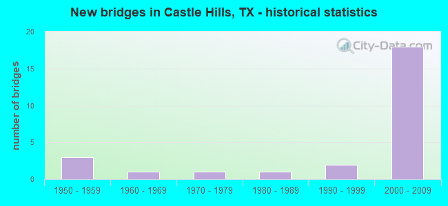
- New bridges - historical statistics
- 31950-1959
- 11960-1969
- 11970-1979
- 11980-1989
- 21990-1999
- 182000-2009


- Bridge Condition - Deck
- 75.0%Good
- 25.0%Satisfactory

- Bridge Condition - Superstructure
- 50.0%Very good
- 37.5%Good
- 12.5%Satisfactory

- Bridge Condition - Substructure
- 62.5%Good
- 25.0%Satisfactory
- 12.5%Fair

- Bridge Condition - Channel
- 8.3%Very good
- 66.7%Good
- 8.3%Satisfactory
- 16.7%Fair

- Bridge Condition - Culverts
- 63.6%Good
- 27.3%Satisfactory
- 9.1%Fair
Find on map >> Show street view
Structure Number: 150150052104026, Location: 0.5 Mi W of FM 1535 (Lat: 29.519122, Lng: -98.521983), Route carried "on" structure: Interstate 410, Year Built: 1957, Year Reconstructed: 2001, Status: Open, Structure Length: 0.79m (2.59ft), Average Daily Traffic: 5,650 (year 2010), Truck Traffic: 3%, Average Future Daily Traffic: 7,910 (year 2030), Features Intersected: Drain
Minimum Vertical Clearance: 30+ m (98+ ft), Kilometerpoint: 30.742, Lanes on structure: 14, Owner: State Highway Agency, Approaching Roadway Width: 55.8m (183.1ft), Skew: 3 degrees, Material/Design: Concrete, Design/Construction: Culvert, Number Of Spans In Main Unit: 4, Length of Maximum Span: 1.5m (4.9ft)
Condition: Channel: Very good, Culverts: Good, Operating Rating: 39.9 metric tons, Method Used To Determine Operating Rating: Load Factor (LF), Inventory Rating: 23.6 metric tons, Method Used To Determine Inventory Rating: Load Factor (LF), Structural Evaluation: Somewhat better than minimum adequacy, Waterway Adequacy: Equal to present minimum criteria, Approach Roadway Alignment: Equal to present desirable criteria, Designated Inspection Frequency: Every 24 months, Inspection Date: July 2020
Find on map >> Show street view
Structure Number: 150150052104027, Location: 0.20 Mi E of FM 1535 (Lat: 29.519694, Lng: -98.510428), Route carried "on" structure: ServiceState highway 410, Year Built: 1957, Year Reconstructed: 2002, Status: Open, Structure Length: 2.16m (7.09ft), Average Daily Traffic: 5,590 (year 2013), Average Future Daily Traffic: 7,820 (year 2033), Features Intersected: Drain
Minimum Vertical Clearance: 30+ m (98+ ft), Kilometerpoint: 31.892, Lanes on structure: 4, Owner: State Highway Agency, Approaching Roadway Width: 15.9m (52.2ft), Material/Design: Concrete, Design/Construction: Culvert, Number Of Spans In Main Unit: 10, Length of Maximum Span: 1.8m (5.9ft), Curb or Sidewalk Widths: Left: 0.0m, Right: 1.7m (5.6ft)
Condition: Channel: Good, Culverts: Good, Operating Rating: 39.9 metric tons, Method Used To Determine Operating Rating: Load Factor (LF), Inventory Rating: 23.6 metric tons, Method Used To Determine Inventory Rating: Load Factor (LF), Structural Evaluation: Somewhat better than minimum adequacy, Waterway Adequacy: Better than present minimum criteria, Approach Roadway Alignment: Equal to present desirable criteria, Designated Inspection Frequency: Every 24 months, Inspection Date: July 2020
Find on map >> Show street view
Structure Number: 150150052104191, Location: 0.1 Mi. E of FM 1535 (Lat: 29.520717, Lng: -98.509617), Route carried "on" structure: Interstate 410, Year Built: 1976, Year Reconstructed: 2003, Status: Open, Structure Length: 1.43m (4.69ft), Average Daily Traffic: 226,296 (year 2020), Truck Traffic: 4%, Average Future Daily Traffic: 338,500 (year 2033), Design Load: H 20, Features Intersected: Drain
Minimum Vertical Clearance: 30+ m (98+ ft), Kilometerpoint: 31.762, Lanes on structure: 13, Owner: State Highway Agency, Approaching Roadway Width: 59.7m (195.9ft), Skew: 34 degrees, Material/Design: Concrete, Design/Construction: Culvert, Number Of Spans In Main Unit: 4, Length of Maximum Span: 2.1m (6.9ft)
Condition: Channel: Good, Culverts: Satisfactory, Operating Rating: 39.9 metric tons, Method Used To Determine Operating Rating: Load Factor (LF), Inventory Rating: 23.6 metric tons, Method Used To Determine Inventory Rating: Load Factor (LF), Structural Evaluation: Somewhat better than minimum adequacy, Waterway Adequacy: Equal to present minimum criteria, Approach Roadway Alignment: Equal to present desirable criteria, Designated Inspection Frequency: Every 24 months, Inspection Date: July 2020
Find on map >> Show street view
Structure Number: 150150052104295, Location: 0.4 Mi E of FM 1535 (Lat: 29.520814, Lng: -98.506861), Route carried "on" structure: State highway 2696, Year Built: 2003, Status: Open, Structure Length: 5.70m (18.70ft), Average Daily Traffic: 32,040 (year 2014), Truck Traffic: 2%, Average Future Daily Traffic: 53,200 (year 2034), Design Load: HS 20, Features Intersected: IH 410
Minimum Vertical Clearance: 5.36m (17.59ft), Kilometerpoint: 29.911, Lanes on structure: 4, Lanes under structure: 12, Owner: State Highway Agency, Approaching Roadway Width: 22.3m (73.2ft), Skew: 31 degrees, Material/Design: Prestressed concrete, Design/Construction: Box Beam or Girders - Multiple, Number Of Spans In Main Unit: 2, Length of Maximum Span: 28.7m (94.2ft), Curb or Sidewalk Widths: Left: 0.0m, Right: 1.8m (5.9ft), Curb-To-Curb Width: 22.2m (72.8ft), Out-to-Out Width: 24.3m (79.7ft)
Condition: Deck: Good, Superstructure: Good, Substructure: Good, Operating Rating: 54.4 metric tons, Method Used To Determine Operating Rating: Assigned rating based on Load Factor Design (LFD) reported in metric tons, Inventory Rating: 32.7 metric tons, Method Used To Determine Inventory Rating: Assigned rating based on Load Factor Design (LFD) reported in metric tons, Structural Evaluation: Better than present minimum criteria, Deck Geometry: Superior to present desirable criteria, Underclear: High priority of corrective action, Approach Roadway Alignment: Equal to present desirable criteria, Designated Inspection Frequency: Every 24 months, Inspection Date: July 2020, Deck Structure Type: Concrete Cast-file-Place
Find on map >> Show street view
Structure Number: 150150052104354, Location: .5 Mi W of Blanco Rd. (Lat: 29.521303, Lng: -98.513356), Route carried "on" structure: Ramp Interstate 1535, Year Built: 2003, Status: Open, Structure Length: 13.05m (42.81ft), Average Daily Traffic: 19,200 (year 2014), Truck Traffic: 2%, Average Future Daily Traffic: 25,000 (year 2034), Design Load: HS 20, Features Intersected: IH 410 ML
Minimum Vertical Clearance: 5.23m (17.16ft), Kilometerpoint: 14.479, Lanes on structure: 4, Lanes under structure: 13, Owner: State Highway Agency, Approaching Roadway Width: 18.3m (60.0ft), Skew: 39 degrees, Material/Design: Prestressed concrete, Design/Construction: Stringer/Multi-beam, Number Of Spans In Main Unit: 5, Length of Maximum Span: 31.7m (104.0ft), Curb-To-Curb Width: 16.9m (55.4ft), Out-to-Out Width: 18.9m (62.0ft)
Condition: Deck: Good, Superstructure: Very good, Substructure: Good, Operating Rating: 54.4 metric tons, Method Used To Determine Operating Rating: Assigned rating based on Load Factor Design (LFD) reported in metric tons, Inventory Rating: 32.7 metric tons, Method Used To Determine Inventory Rating: Assigned rating based on Load Factor Design (LFD) reported in metric tons, Structural Evaluation: Better than present minimum criteria, Deck Geometry: Somewhat better than minimum adequacy, Underclear: Meets minimum limits, Approach Roadway Alignment: Equal to present desirable criteria, Length Of Structure Improvement: 13.05m (42.81ft), Designated Inspection Frequency: Every 24 months, Inspection Date: July 2020, Bridge Improvement Cost: $48,000, Roadway Improvement Cost: $12,000, Total Project Cost: $60,000, Deck Structure Type: Concrete Precast Panels
Find on map >> Show street view
Structure Number: 150150052104356, Location: 0.5 Mi W of Blanco Rd (Lat: 29.521000, Lng: -98.511339), Route carried "on" structure: Ramp Interstate 410, Year Built: 2003, Status: Open, Structure Length: 20.57m (67.49ft), Average Daily Traffic: 15,800 (year 2014), Truck Traffic: 3%, Average Future Daily Traffic: 22,120 (year 2034), Design Load: HS 20, Features Intersected: IH 410 WBFR & On-Rp
Minimum Vertical Clearance: 6.96m (22.83ft), Kilometerpoint: 31.443, Lanes on structure: 1, Lanes under structure: 3, Owner: State Highway Agency, Approaching Roadway Width: 7.0m (23.0ft), Skew: 9 degrees, Material/Design: Prestressed concrete, Design/Construction: Stringer/Multi-beam, Number Of Spans In Main Unit: 5, Number Of Approach Spans: 2, Length of Maximum Span: 35.1m (115.2ft), Curb-To-Curb Width: 7.1m (23.3ft), Out-to-Out Width: 7.9m (25.9ft)
Condition: Deck: Good, Superstructure: Very good, Substructure: Good, Operating Rating: 54.4 metric tons, Method Used To Determine Operating Rating: Assigned rating based on Load Factor Design (LFD) reported in metric tons, Inventory Rating: 32.7 metric tons, Method Used To Determine Inventory Rating: Assigned rating based on Load Factor Design (LFD) reported in metric tons, Structural Evaluation: Better than present minimum criteria, Deck Geometry: Equal to present minimum criteria, Underclear: High priority of corrective action, Approach Roadway Alignment: Equal to present desirable criteria, Designated Inspection Frequency: Every 24 months, Inspection Date: July 2020, Deck Structure Type: Concrete Precast Panels
Find on map >> Show street view
Structure Number: 150150052104357, Location: 0.15 Mi. W of FM 2696 (Lat: 29.520406, Lng: -98.509925), Route carried "on" structure: Interstate 410, Year Built: 1957, Year Reconstructed: 2003, Status: Open, Structure Length: 1.01m (3.31ft), Average Daily Traffic: 226,296 (year 2020), Truck Traffic: 3%, Average Future Daily Traffic: 221,210 (year 2034), Features Intersected: Draw
Minimum Vertical Clearance: 30+ m (98+ ft), Kilometerpoint: 31.604, Lanes on structure: 13, Owner: State Highway Agency, Approaching Roadway Width: 58.8m (192.9ft), Skew: 3 degrees, Material/Design: Concrete, Design/Construction: Culvert, Number Of Spans In Main Unit: 4, Length of Maximum Span: 1.8m (5.9ft), Curb or Sidewalk Widths: Left: 1.7m (5.6ft), Right: 0.0m
Condition: Channel: Good, Culverts: Fair, Operating Rating: 39.9 metric tons, Method Used To Determine Operating Rating: Load Factor (LF), Inventory Rating: 23.6 metric tons, Method Used To Determine Inventory Rating: Load Factor (LF), Structural Evaluation: Somewhat better than minimum adequacy, Waterway Adequacy: Equal to present minimum criteria, Approach Roadway Alignment: Equal to present desirable criteria, Designated Inspection Frequency: Every 24 months, Inspection Date: July 2020
Find on map >> Show street view
Structure Number: 150150052104358, Location: 0.30 Mi. E of FM 1535 (Lat: 29.520078, Lng: -98.510211), Route carried "on" structure: Ramp Interstate 410, Year Built: 2003, Status: Open, Structure Length: 1.77m (5.81ft), Average Daily Traffic: 15,800 (year 2014), Truck Traffic: 3%, Average Future Daily Traffic: 22,120 (year 2034), Design Load: HS 20, Features Intersected: Draw
Minimum Vertical Clearance: 30+ m (98+ ft), Kilometerpoint: 31.604, Lanes on structure: 1, Owner: State Highway Agency, Approaching Roadway Width: 7.3m (24.0ft), Skew: 5 degrees, Material/Design: Concrete, Design/Construction: Culvert, Number Of Spans In Main Unit: 4, Length of Maximum Span: 2.1m (6.9ft)
Condition: Channel: Good, Culverts: Good, Operating Rating: 44.4 metric tons, Method Used To Determine Operating Rating: No rating analysis performed, Inventory Rating: 32.7 metric tons, Method Used To Determine Inventory Rating: No rating analysis performed, Structural Evaluation: Better than present minimum criteria, Waterway Adequacy: Equal to present minimum criteria, Approach Roadway Alignment: Equal to present desirable criteria, Designated Inspection Frequency: Every 24 months, Inspection Date: July 2020
Find on map >> Show street view
Structure Number: 150150052104359, Location: 0.40 Mi W of FM 2696 (Lat: 29.521992, Lng: -98.513467), Route carried "on" structure: ServiceInterstate 410, Year Built: 1960, Year Reconstructed: 2003, Status: Open, Structure Length: 1.31m (4.30ft), Average Daily Traffic: 15,800 (year 2014), Truck Traffic: 3%, Average Future Daily Traffic: 22,120 (year 2034), Features Intersected: Draw
Minimum Vertical Clearance: 30+ m (98+ ft), Kilometerpoint: 31.604, Lanes on structure: 2, Owner: State Highway Agency, Approaching Roadway Width: 7.3m (24.0ft), Material/Design: Concrete, Design/Construction: Culvert, Number Of Spans In Main Unit: 6, Length of Maximum Span: 1.8m (5.9ft), Curb or Sidewalk Widths: Left: 1.5m (4.9ft), Right: 0.0m
Condition: Channel: Good, Culverts: Good, Operating Rating: 32.7 metric tons, Method Used To Determine Operating Rating: Field evaluation and documented engineering judgment, Inventory Rating: 24.5 metric tons, Method Used To Determine Inventory Rating: Field evaluation and documented engineering judgment, Structural Evaluation: Equal to present minimum criteria, Waterway Adequacy: Better than present minimum criteria, Approach Roadway Alignment: Equal to present desirable criteria, Designated Inspection Frequency: Every 24 months, Inspection Date: July 2020
Find on map >> Show street view
Structure Number: 15015005210436, Location: 0.35 Mi E of FM 1535 (Lat: 29.520025, Lng: -98.510478), Route carried "on" structure: Ramp Interstate 410, Year Built: 2003, Status: Open, Structure Length: 1.22m (4.00ft), Average Daily Traffic: 15,800 (year 2014), Truck Traffic: 3%, Average Future Daily Traffic: 22,120 (year 2034), Design Load: HS 20, Features Intersected: Draw
Minimum Vertical Clearance: 30+ m (98+ ft), Kilometerpoint: 31.604, Lanes on structure: 1, Owner: State Highway Agency, Approaching Roadway Width: 7.3m (24.0ft), Skew: 4 degrees, Material/Design: Concrete, Design/Construction: Culvert, Number Of Spans In Main Unit: 4, Length of Maximum Span: 1.8m (5.9ft)
Condition: Channel: Good, Culverts: Good, Operating Rating: 44.4 metric tons, Method Used To Determine Operating Rating: No rating analysis performed, Inventory Rating: 32.7 metric tons, Method Used To Determine Inventory Rating: No rating analysis performed, Structural Evaluation: Better than present minimum criteria, Waterway Adequacy: Better than present minimum criteria, Approach Roadway Alignment: Equal to present desirable criteria, Designated Inspection Frequency: Every 48 months, Inspection Date: July 2018
Find on map >> Show street view
Structure Number: 150150052104361, Location: 0.1 MI E of West Ave (Lat: 29.517139, Lng: -98.525378), Route carried "on" structure: ServiceInterstate 410, Year Built: 2003, Status: Open, Structure Length: 3.60m (11.81ft), Average Daily Traffic: 15,250 (year 2014), Truck Traffic: 3%, Average Future Daily Traffic: 25,450 (year 2034), Design Load: HS 20, Features Intersected: Olmos Creek
Minimum Vertical Clearance: 30+ m (98+ ft), Kilometerpoint: 30.336, Lanes on structure: 10, Owner: State Highway Agency, Approaching Roadway Width: 24.7m (81.0ft), Skew: 9 degrees, Material/Design: Concrete, Design/Construction: Culvert, Number Of Spans In Main Unit: 7, Length of Maximum Span: 4.0m (13.1ft)
Condition: Channel: Good, Culverts: Satisfactory, Operating Rating: 44.4 metric tons, Method Used To Determine Operating Rating: No rating analysis performed, Inventory Rating: 32.7 metric tons, Method Used To Determine Inventory Rating: No rating analysis performed, Structural Evaluation: Equal to present minimum criteria, Waterway Adequacy: Equal to present minimum criteria, Approach Roadway Alignment: Equal to present desirable criteria, Designated Inspection Frequency: Every 24 months, Inspection Date: July 2020
Find on map >> Show street view
Structure Number: 150150052104363, Location: 1.8 Mi W of US 281 (Lat: 29.517661, Lng: -98.525453), Route carried "on" structure: Interstate 410, Year Built: 2002, Status: Open, Structure Length: 38.53m (126.41ft), Average Daily Traffic: 126,768 (year 2017), Truck Traffic: 4%, Average Future Daily Traffic: 169,250 (year 2033), Design Load: HS 20, Features Intersected: Jackson-Kellar Rd & SPRR
Minimum Vertical Clearance: 30+ m (98+ ft), Kilometerpoint: 29.910, Lanes on structure: 6, Lanes under structure: 12, Owner: State Highway Agency, Approaching Roadway Width: 25.6m (84.0ft), Skew: 9 degrees, Material/Design: Prestressed concrete, Design/Construction: Stringer/Multi-beam, Number Of Spans In Main Unit: 9, Number Of Approach Spans: 2, Length of Maximum Span: 40.2m (131.9ft), Curb-To-Curb Width: 25.7m (84.3ft), Out-to-Out Width: 26.4m (86.6ft)
Condition: Deck: Good, Superstructure: Good, Substructure: Satisfactory, Operating Rating: 54.4 metric tons, Method Used To Determine Operating Rating: Assigned rating based on Load Factor Design (LFD) reported in metric tons, Inventory Rating: 32.7 metric tons, Method Used To Determine Inventory Rating: Assigned rating based on Load Factor Design (LFD) reported in metric tons, Structural Evaluation: Equal to present minimum criteria, Deck Geometry: Meets minimum limits, Underclear: Better than present minimum criteria, Approach Roadway Alignment: Equal to present desirable criteria, Designated Inspection Frequency: Every 24 months, Inspection Date: July 2020, Deck Structure Type: Concrete Precast Panels
Find on map >> Show street view
Structure Number: 150150052104364, Location: 0.4 Mi W of FM 1535 (Lat: 29.519356, Lng: -98.519844), Route carried "on" structure: Interstate 410, Year Built: 2002, Status: Open, Structure Length: 8.26m (27.10ft), Average Daily Traffic: 122,454 (year 2017), Truck Traffic: 4%, Average Future Daily Traffic: 169,250 (year 2033), Design Load: HS 20, Features Intersected: Honeysuckle Lane
Minimum Vertical Clearance: 30+ m (98+ ft), Kilometerpoint: 30.846, Lanes on structure: 6, Lanes under structure: 6, Owner: State Highway Agency, Approaching Roadway Width: 25.6m (84.0ft), Skew: 1 degrees, Material/Design: Prestressed concrete, Design/Construction: Stringer/Multi-beam, Number Of Spans In Main Unit: 1, Number Of Approach Spans: 2, Length of Maximum Span: 36.5m (119.8ft), Curb-To-Curb Width: 25.7m (84.3ft), Out-to-Out Width: 26.4m (86.6ft)
Condition: Deck: Good, Superstructure: Very good, Substructure: Good, Operating Rating: 54.4 metric tons, Method Used To Determine Operating Rating: Assigned rating based on Load Factor Design (LFD) reported in metric tons, Inventory Rating: 32.7 metric tons, Method Used To Determine Inventory Rating: Assigned rating based on Load Factor Design (LFD) reported in metric tons, Structural Evaluation: Better than present minimum criteria, Deck Geometry: Meets minimum limits, Underclear: Superior to present desirable criteria, Approach Roadway Alignment: Equal to present desirable criteria, Designated Inspection Frequency: Every 24 months, Inspection Date: July 2020, Deck Structure Type: Concrete Precast Panels
Find on map >> Show street view
Structure Number: 150150052104365, Location: 0.4 Mi W of FM 1535 (Lat: 29.519864, Lng: -98.519464), Route carried "on" structure: Interstate 410, Year Built: 2002, Status: Open, Structure Length: 8.26m (27.10ft), Average Daily Traffic: 126,768 (year 2017), Truck Traffic: 4%, Average Future Daily Traffic: 169,250 (year 2033), Design Load: HS 20, Features Intersected: Honeysuckle Lane
Minimum Vertical Clearance: 30+ m (98+ ft), Kilometerpoint: 30.846, Lanes on structure: 5, Lanes under structure: 6, Owner: State Highway Agency, Approaching Roadway Width: 22.3m (73.2ft), Skew: 1 degrees, Material/Design: Prestressed concrete, Design/Construction: Stringer/Multi-beam, Number Of Spans In Main Unit: 1, Number Of Approach Spans: 2, Length of Maximum Span: 36.5m (119.8ft), Curb-To-Curb Width: 22.4m (73.5ft), Out-to-Out Width: 23.1m (75.8ft)
Condition: Deck: Satisfactory, Superstructure: Good, Substructure: Good, Operating Rating: 54.4 metric tons, Method Used To Determine Operating Rating: Assigned rating based on Load Factor Design (LFD) reported in metric tons, Inventory Rating: 32.7 metric tons, Method Used To Determine Inventory Rating: Assigned rating based on Load Factor Design (LFD) reported in metric tons, Structural Evaluation: Better than present minimum criteria, Deck Geometry: Meets minimum limits, Underclear: Superior to present desirable criteria, Approach Roadway Alignment: Equal to present desirable criteria, Designated Inspection Frequency: Every 24 months, Inspection Date: July 2020, Deck Structure Type: Concrete Precast Panels
Find on map >> Show street view
Structure Number: 150150052104366, Location: 1.6 Mi W of US 281 (Lat: 29.519406, Lng: -98.521014), Route carried "on" structure: Ramp State highway 410, Year Built: 2003, Status: Open, Structure Length: 23.23m (76.21ft), Average Daily Traffic: 5,000 (year 2014), Truck Traffic: 5%, Average Future Daily Traffic: 15,000 (year 2034), Design Load: HS 20, Features Intersected: IH 410 WB On-Rp
Minimum Vertical Clearance: 30+ m (98+ ft), Kilometerpoint: 32.188, Lanes on structure: 1, Lanes under structure: 1, Owner: State Highway Agency, Approaching Roadway Width: 7.3m (24.0ft), Material/Design: Prestressed concrete, Design/Construction: Stringer/Multi-beam, Number Of Spans In Main Unit: 10, Length of Maximum Span: 26.0m (85.3ft), Curb-To-Curb Width: 7.2m (23.6ft), Out-to-Out Width: 7.8m (25.6ft)
Condition: Deck: Good, Superstructure: Very good, Substructure: Satisfactory, Operating Rating: 54.4 metric tons, Method Used To Determine Operating Rating: Assigned rating based on Load Factor Design (LFD) reported in metric tons, Inventory Rating: 32.7 metric tons, Method Used To Determine Inventory Rating: Assigned rating based on Load Factor Design (LFD) reported in metric tons, Structural Evaluation: Equal to present minimum criteria, Deck Geometry: Equal to present minimum criteria, Underclear: High priority of corrective action, Approach Roadway Alignment: Equal to present desirable criteria, Designated Inspection Frequency: Every 24 months, Inspection Date: July 2020, Deck Structure Type: Concrete Precast Panels
Find on map >> Show street view
Structure Number: 150150065801016, Location: 0.7 Mi NW of IH 410 (Lat: 29.529264, Lng: -98.519808), Route carried "on" structure: State highway 1535, Year Built: 1997, Status: Open, Structure Length: 0.94m (3.08ft), Average Daily Traffic: 22,915 (year 2015), Truck Traffic: 5%, Average Future Daily Traffic: 35,340 (year 2033), Design Load: HS 20, Features Intersected: Draw
Minimum Vertical Clearance: 30+ m (98+ ft), Kilometerpoint: 13.322, Lanes on structure: 6, Owner: State Highway Agency, Approaching Roadway Width: 19.5m (64.0ft), Material/Design: Concrete, Design/Construction: Culvert, Number Of Spans In Main Unit: 3, Length of Maximum Span: 2.7m (8.9ft), Curb or Sidewalk Widths: Left: 1.7m (5.6ft), Right: 1.7m (5.6ft)
Condition: Channel: Good, Culverts: Good, Operating Rating: 39.9 metric tons, Method Used To Determine Operating Rating: Load Factor (LF), Inventory Rating: 23.6 metric tons, Method Used To Determine Inventory Rating: Load Factor (LF), Structural Evaluation: Somewhat better than minimum adequacy, Waterway Adequacy: Equal to present minimum criteria, Approach Roadway Alignment: Equal to present desirable criteria, Designated Inspection Frequency: Every 48 months, Inspection Date: August 2018
Find on map >> Show street view
Structure Number: 150150065801017, Location: 1.5 Mi NW of IH 410 (Lat: 29.538786, Lng: -98.526592), Route carried "on" structure: State highway 1535, Year Built: 1997, Status: Open, Structure Length: 0.73m (2.40ft), Average Daily Traffic: 21,000 (year 2016), Average Future Daily Traffic: 29,400 (year 2036), Design Load: HS 20, Features Intersected: Draw
Minimum Vertical Clearance: 30+ m (98+ ft), Kilometerpoint: 26.197, Lanes on structure: 7, Owner: State Highway Agency, Approaching Roadway Width: 31.4m (103.0ft), Skew: 3 degrees, Material/Design: Concrete, Design/Construction: Culvert, Number Of Spans In Main Unit: 2, Length of Maximum Span: 2.4m (7.9ft), Curb or Sidewalk Widths: Left: 1.4m (4.6ft), Right: 1.6m (5.2ft), Curb-To-Curb Width: 31.4m (103.0ft), Out-to-Out Width: 35.3m (115.8ft)
Condition: Channel: Fair, Culverts: Satisfactory, Operating Rating: 39.9 metric tons, Method Used To Determine Operating Rating: Load Factor (LF), Inventory Rating: 23.6 metric tons, Method Used To Determine Inventory Rating: Load Factor (LF), Structural Evaluation: Somewhat better than minimum adequacy, Deck Geometry: Equal to present desirable criteria, Waterway Adequacy: Equal to present minimum criteria, Approach Roadway Alignment: Equal to present desirable criteria, Designated Inspection Frequency: Every 24 months, Inspection Date: July 2020
Find on map >> Show street view
Structure Number: 150150B17460012, Location: 0.3 MI SE OF JCT LP 410 (Lat: 29.513592, Lng: -98.523703), Route carried "on" structure: City street 8013, Year Built: 1986, Status: Open, Structure Length: 3.66m (12.01ft), Average Daily Traffic: 14,162 (year 2020), Truck Traffic: 1%, Average Future Daily Traffic: 20,000 (year 2031), Design Load: HS 20, Features Intersected: OLMOS CREEK, Facility Carried by Structure: JACKSON-KELLER
Minimum Vertical Clearance: 30+ m (98+ ft), Kilometerpoint: 1.255, Lanes on structure: 4, Owner: City or Municipal Highway Agency, Approaching Roadway Width: 13.4m (44.0ft), Material/Design: Concrete, Design/Construction: Stringer/Multi-beam, Number Of Spans In Main Unit: 3, Length of Maximum Span: 12.2m (40.0ft), Curb or Sidewalk Widths: Left: 1.4m (4.6ft), Right: 1.4m (4.6ft), Curb-To-Curb Width: 13.4m (44.0ft), Out-to-Out Width: 17.1m (56.1ft)
Condition: Deck: Satisfactory, Superstructure: Satisfactory, Substructure: Fair, Channel: Fair, Operating Rating: 50.8 metric tons, Method Used To Determine Operating Rating: Load Factor (LF), Inventory Rating: 29.9 metric tons, Method Used To Determine Inventory Rating: Load Factor (LF), Structural Evaluation: Somewhat better than minimum adequacy, Deck Geometry: High priority of replacement, Waterway Adequacy: Equal to present minimum criteria, Approach Roadway Alignment: Equal to present desirable criteria, Length Of Structure Improvement: 3.66m (12.01ft), Designated Inspection Frequency: Every 24 months, Inspection Date: June 2021, Bridge Improvement Cost: $11,000, Roadway Improvement Cost: $3,000, Total Project Cost: $14,000, Deck Structure Type: Concrete Cast-file-Place
Find on map >> Show street view
Structure Number: 150150B36545001, Location: 0.35 MI N OF LP 410 (Lat: 29.523622, Lng: -98.526008), Route carried "on" structure: City street , Year Built: 2002, Status: Open, Structure Length: 0.79m (2.59ft), Average Daily Traffic: 3,000 (year 2018), Average Future Daily Traffic: 3,500 (year 2038), Design Load: HS 20, Features Intersected: DRAW, Facility Carried by Structure: WEST AVE
Minimum Vertical Clearance: 30+ m (98+ ft), Kilometerpoint: 1.609, Lanes on structure: 4, Owner: City or Municipal Highway Agency, Approaching Roadway Width: 14.6m (47.9ft), Skew: 9 degrees, Material/Design: Concrete, Design/Construction: Culvert, Number Of Spans In Main Unit: 3, Length of Maximum Span: 2.4m (7.9ft), Curb or Sidewalk Widths: Left: 0.0m, Right: 1.8m (5.9ft), Curb-To-Curb Width: 18.6m (61.0ft), Out-to-Out Width: 22.9m (75.1ft)
Condition: Channel: Satisfactory, Culverts: Good, Operating Rating: 44.4 metric tons, Method Used To Determine Operating Rating: Assigned rating based on Load Factor Design (LFD) reported in metric tons, Inventory Rating: 32.7 metric tons, Method Used To Determine Inventory Rating: Assigned rating based on Load Factor Design (LFD) reported in metric tons, Structural Evaluation: Better than present minimum criteria, Deck Geometry: Equal to present minimum criteria, Waterway Adequacy: Equal to present minimum criteria, Approach Roadway Alignment: Equal to present desirable criteria, Designated Inspection Frequency: Every 24 months, Inspection Date: June 2021, Deck Structure Type: Concrete Cast-file-Place, Wearing Surface/Protective System: Wearing Surface: Bituminous
Find on map >> Show street view
Structure Number: 150150052104295, Location: 0.4 Mi E of FM 1535 (Lat: 29.520814, Lng: -98.506861), Route carried "under" structure: Interstate 410, Year Built: 2003, Structure Length: 0. m, Average Daily Traffic: 158,000 (year 2014), Truck Traffic: 3%, Features Intersected: IH 410, Facility Carried by Structure: FM2696 SB (Blanco)
Minimum Vertical Clearance: 5.36m (17.59ft), Kilometerpoint: 32.248, Lanes under structure: 12, Material/Design: Prestressed concrete, Design/Construction: Box Beam or Girders - Multiple, Length of Maximum Span: 28.7m (94.2ft)
Find on map >> Show street view
Structure Number: 150150052104354, Location: .5 Mi W of Blanco Rd. (Lat: 29.521303, Lng: -98.513356), Route carried "under" structure: Interstate 410, Year Built: 2003, Structure Length: 0. m, Average Daily Traffic: 79,000 (year 2014), Truck Traffic: 3%, Features Intersected: IH 410 ML, Facility Carried by Structure: FM 1535
Minimum Vertical Clearance: 5.49m (18.01ft), Kilometerpoint: 31.609, Lanes on structure: 4, Lanes under structure: 13, Material/Design: Prestressed concrete, Design/Construction: Stringer/Multi-beam, Length of Maximum Span: 31.7m (104.0ft)
Find on map >> Show street view
Structure Number: 150150052104356, Location: 0.5 Mi W of Blanco Rd (Lat: 29.521000, Lng: -98.511339), Route carried "under" structure: ServiceInterstate 410, Year Built: 2003, Structure Length: 0. m, Average Daily Traffic: 90,000 (year 2014), Truck Traffic: 3%, Features Intersected: IH 410 WBFR & On-Rp
Minimum Vertical Clearance: 5.89m (19.32ft), Kilometerpoint: 31.516, Lanes under structure: 3, Material/Design: Prestressed concrete, Design/Construction: Stringer/Multi-beam, Length of Maximum Span: 35.1m (115.2ft)
Find on map >> Show street view
Structure Number: 150150052104363, Location: 1.8 Mi W of US 281 (Lat: 29.517661, Lng: -98.525453), Route carried "under" structure: City street , Year Built: 2002, Structure Length: 0. m, Average Daily Traffic: 18,200 (year 2014), Truck Traffic: 3%, Features Intersected: Jackson-Kellar Rd & SPRR, Facility Carried by Structure: IH 410 WB
Minimum Vertical Clearance: 8.28m (27.17ft), Kilometerpoint: 30.022, Lanes on structure: 6, Lanes under structure: 12, Material/Design: Prestressed concrete, Design/Construction: Stringer/Multi-beam, Length of Maximum Span: 40.2m (131.9ft)
Find on map >> Show street view
Structure Number: 150150052104364, Location: 0.4 Mi W of FM 1535 (Lat: 29.519356, Lng: -98.519844), Route carried "under" structure: City street , Year Built: 2002, Structure Length: 0. m, Average Daily Traffic: 8,570 (year 2014), Truck Traffic: 3%, Features Intersected: Honeysuckle Lane, Facility Carried by Structure: IH 410 EB
Minimum Vertical Clearance: 5.74m (18.83ft), Kilometerpoint: 30.953, Lanes on structure: 6, Lanes under structure: 6, Material/Design: Prestressed concrete, Design/Construction: Stringer/Multi-beam, Length of Maximum Span: 36.5m (119.8ft)
Find on map >> Show street view
Structure Number: 150150052104365, Location: 0.4 Mi W of FM 1535 (Lat: 29.519864, Lng: -98.519464), Route carried "under" structure: City street , Year Built: 2002, Structure Length: 0. m, Average Daily Traffic: 8,570 (year 2014), Truck Traffic: 3%, Features Intersected: Honeysuckle Lane, Facility Carried by Structure: IH 410 WB
Minimum Vertical Clearance: 5.89m (19.32ft), Kilometerpoint: 30.953, Lanes on structure: 5, Lanes under structure: 6, Material/Design: Prestressed concrete, Design/Construction: Stringer/Multi-beam, Length of Maximum Span: 36.5m (119.8ft)
Find on map >> Show street view
Structure Number: 150150052104366, Location: 1.6 Mi W of US 281 (Lat: 29.519406, Lng: -98.521014), Route carried "under" structure: Ramp State highway 410, Year Built: 2003, Structure Length: 0. m, Average Daily Traffic: 5,000 (year 2014), Truck Traffic: 5%, Features Intersected: IH 410 WB On-Rp
Minimum Vertical Clearance: 4.95m (16.24ft), Kilometerpoint: 0.399, Lanes on structure: 1, Lanes under structure: 1, Material/Design: Prestressed concrete, Design/Construction: Stringer/Multi-beam, Length of Maximum Span: 26.0m (85.3ft)