Bridge Statistics for Cathedral City, California (CA)
Condition, Traffic, Stress, Structural Evaluation, Project Costs
- National Bridge Inventory (NBI) Statistics
- 10Number of bridges
- 157ft / 47.8mTotal length
- 350,000Total average daily traffic
- 31,480Total average daily truck traffic
- National Bridge Inventory (NBI) Registered Bridges for Cathedral City
- No street view available for this location
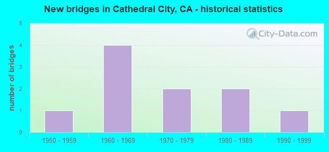
- New bridges - historical statistics
- 11950-1959
- 41960-1969
- 21970-1979
- 21980-1989
- 11990-1999

- Reconstructed bridges - Historical Statistics
- 11960-1969
- 01970-1979
- 11980-1989
- 01990-1999
- 22000-2009
- 22010-2019


- Bridge Condition - Deck
- 88.9%Good
- 11.1%Fair

- Bridge Condition - Superstructure
- 88.9%Good
- 11.1%Fair

- Bridge Condition - Channel
- 50.0%Excellent
- 37.5%Very good
- 12.5%Good
Find on map >> Show street view
Structure Number: 56 0303, Location: 08-RIV-010-37.14 (Lat: 33.868958, Lng: -116.491564), Route carried "on" structure: Interstate 10, Year Built: 1955, Year Reconstructed: 1969, Status: Open, Structure Length: 2.22m (7.28ft), Average Daily Traffic: 94,000 (year 2012), Truck Traffic: 24%, Average Future Daily Traffic: 147,108 (year 2038), Design Load: HS 20, Features Intersected: WILLOW WASH
Minimum Vertical Clearance: 30+ m (98+ ft), Kilometerpoint: 37.140, Lanes on structure: 8, Base Highway Network: Yes (, Subroute: 1), Owner: State Highway Agency, Approaching Roadway Width: 40.4m (132.5ft), Skew: 20 degrees, Material/Design: Concrete continuous, Design/Construction: Slab, Number Of Spans In Main Unit: 3, Length of Maximum Span: 8.8m (28.9ft), Curb-To-Curb Width: 40.4m (132.5ft), Out-to-Out Width: 50.4m (165.4ft)
Condition: Deck: Good, Superstructure: Good, Substructure: Good, Channel: Very good, Operating Rating: 76.1 metric tons, Method Used To Determine Operating Rating: Load Factor (LF), Inventory Rating: 45.7 metric tons, Method Used To Determine Inventory Rating: Load Factor (LF), Structural Evaluation: Better than present minimum criteria, Deck Geometry: Superior to present desirable criteria, Waterway Adequacy: Equal to present desirable criteria, Approach Roadway Alignment: Equal to present desirable criteria, Designated Inspection Frequency: Every 24 months, Inspection Date: October 2021, Deck Structure Type: Concrete Cast-file-Place, Wearing Surface/Protective System: Wearing Surface: Bituminous
Find on map >> Show street view
Structure Number: 56C0073, Location: 0.2 MI. S/O RTE. I-10 FWY (Lat: 33.846500, Lng: -116.458167), Route carried "on" structure: City street , Year Built: 1966, Year Reconstructed: 2006, Status: Open, Structure Length: 5.27m (17.29ft), Average Daily Traffic: 24,000 (year 2017), Truck Traffic: 3%, Average Future Daily Traffic: 50,122 (year 2036), Design Load: HS 20, Features Intersected: UP RR & AMTRAK, Facility Carried by Structure: DATE PALM DRIVE
Minimum Vertical Clearance: 30+ m (98+ ft), Kilometerpoint: 0.000, Lanes on structure: 5, Base Highway Network: Yes, Owner: City or Municipal Highway Agency, Approaching Roadway Width: 27.8m (91.2ft), Skew: 13 degrees, Material/Design: Concrete continuous, Design/Construction: Tee Beam, Number Of Spans In Main Unit: 3, Length of Maximum Span: 19.8m (65.0ft), Curb or Sidewalk Widths: Left: 1.5m (4.9ft), Right: 1.5m (4.9ft), Curb-To-Curb Width: 27.8m (91.2ft), Out-to-Out Width: 42.3m (138.8ft)
Condition: Deck: Good, Superstructure: Good, Substructure: Good, Operating Rating: 54.1 metric tons, Method Used To Determine Operating Rating: Assigned rating based on Load Factor Design (LFD) reported in metric tons, Inventory Rating: 32.4 metric tons, Method Used To Determine Inventory Rating: Assigned rating based on Load Factor Design (LFD) reported in metric tons, Structural Evaluation: Better than present minimum criteria, Deck Geometry: Superior to present desirable criteria, Underclear: Superior to present desirable criteria, Approach Roadway Alignment: Equal to present desirable criteria, Designated Inspection Frequency: Every 48 months, Inspection Date: November 2018, Deck Structure Type: Concrete Cast-file-Place, Wearing Surface/Protective System: Wearing Surface: Monolithic Concrete, Deck Protection: Bituminous
Find on map >> Show street view
Structure Number: 56C0189, Location: 0.4 MI N/O PALM CANYON DR (Lat: 33.782514, Lng: -116.457989), Route carried "on" structure: City street , Year Built: 1981, Year Reconstructed: 2018, Status: Open, Structure Length: 23.10m (75.79ft), Average Daily Traffic: 22,000 (year 2020), Truck Traffic: 1%, Average Future Daily Traffic: 45,945 (year 2037), Design Load: HS 20+Mod, Features Intersected: WHITEWATER RIVER, Facility Carried by Structure: DATE PALM DRIVE
Minimum Vertical Clearance: 30+ m (98+ ft), Kilometerpoint: 0.000, Lanes on structure: 6, Owner: City or Municipal Highway Agency, Approaching Roadway Width: 29.3m (96.1ft), Skew: 14 degrees, Material/Design: Prestressed concrete continuous, Design/Construction: Stringer/Multi-beam, Number Of Spans In Main Unit: 9, Length of Maximum Span: 28.0m (91.9ft), Curb or Sidewalk Widths: Left: 1.5m (4.9ft), Right: 1.5m (4.9ft), Curb-To-Curb Width: 22.0m (72.2ft), Out-to-Out Width: 29.3m (96.1ft)
Condition: Deck: Good, Superstructure: Good, Substructure: Good, Channel: Very good, Operating Rating: 82.6 metric tons, Method Used To Determine Operating Rating: Load Factor (LF), Inventory Rating: 32.4 metric tons, Method Used To Determine Inventory Rating: Load Factor (LF), Structural Evaluation: Better than present minimum criteria, Deck Geometry: High priority of corrective action, Waterway Adequacy: Equal to present desirable criteria, Approach Roadway Alignment: Equal to present desirable criteria, Designated Inspection Frequency: Every 24 months, Inspection Date: November 2020, Deck Structure Type: Concrete Cast-file-Place
Find on map >> Show street view
Structure Number: 56C0195, Location: 0.22 MI. N/O RTE. 111 HWY (Lat: 33.780736, Lng: -116.457861), Route carried "on" structure: City street , Year Built: 1973, Status: Open, Structure Length: 1.46m (4.79ft), Average Daily Traffic: 22,000 (year 2020), Truck Traffic: 1%, Average Future Daily Traffic: 45,945 (year 2037), Design Load: HS 20, Features Intersected: CATHEDRAL CYN N CHANNEL, Facility Carried by Structure: DATE PALM DRIVE
Minimum Vertical Clearance: 30+ m (98+ ft), Kilometerpoint: 0.000, Lanes on structure: 5, Owner: City or Municipal Highway Agency, Approaching Roadway Width: 25.8m (84.6ft), Skew: 1 degrees, Material/Design: Concrete continuous, Design/Construction: Slab, Number Of Spans In Main Unit: 2, Length of Maximum Span: 7.3m (24.0ft), Curb or Sidewalk Widths: Left: 1.6m (5.2ft), Right: 0.0m, Curb-To-Curb Width: 25.8m (84.6ft), Out-to-Out Width: 27.7m (90.9ft)
Condition: Deck: Good, Superstructure: Good, Substructure: Good, Channel: Excellent, Operating Rating: 88.5 metric tons, Method Used To Determine Operating Rating: Load Factor (LF), Inventory Rating: 53.1 metric tons, Method Used To Determine Inventory Rating: Load Factor (LF), Structural Evaluation: Better than present minimum criteria, Deck Geometry: Superior to present desirable criteria, Waterway Adequacy: Equal to present desirable criteria, Approach Roadway Alignment: Equal to present desirable criteria, Designated Inspection Frequency: Every 24 months, Inspection Date: November 2020, Deck Structure Type: Concrete Cast-file-Place, Wearing Surface/Protective System: Wearing Surface: Bituminous
Find on map >> Show street view
Structure Number: 56C0211, Location: 0.3 MI N/O PALM CANYON DR (Lat: 33.783289, Lng: -116.466717), Route carried "on" structure: City street , Year Built: 1973, Year Reconstructed: 1988, Status: Open, Structure Length: 1.52m (4.99ft), Average Daily Traffic: 16,000 (year 2020), Truck Traffic: 1%, Average Future Daily Traffic: 33,415 (year 2037), Design Load: HS 20, Features Intersected: CATHEDRAL CYN N. CHANNEL, Facility Carried by Structure: CATHEDRAL CNYN DR.
Minimum Vertical Clearance: 30+ m (98+ ft), Kilometerpoint: 0.000, Lanes on structure: 5, Owner: City or Municipal Highway Agency, Approaching Roadway Width: 19.5m (64.0ft), Material/Design: Concrete continuous, Design/Construction: Slab, Number Of Spans In Main Unit: 2, Length of Maximum Span: 7.3m (24.0ft), Curb or Sidewalk Widths: Left: 1.5m (4.9ft), Right: 1.5m (4.9ft), Curb-To-Curb Width: 19.5m (64.0ft), Out-to-Out Width: 23.2m (76.1ft)
Condition: Deck: Good, Superstructure: Good, Substructure: Good, Channel: Excellent, Operating Rating: 54.1 metric tons, Method Used To Determine Operating Rating: Assigned rating based on Load Factor Design (LFD) reported in metric tons, Inventory Rating: 32.4 metric tons, Method Used To Determine Inventory Rating: Assigned rating based on Load Factor Design (LFD) reported in metric tons, Structural Evaluation: Better than present minimum criteria, Deck Geometry: Meets minimum limits, Waterway Adequacy: Equal to present desirable criteria, Approach Roadway Alignment: Equal to present desirable criteria, Designated Inspection Frequency: Every 24 months, Inspection Date: November 2020, Deck Structure Type: Concrete Cast-file-Place, Wearing Surface/Protective System: Wearing Surface: Bituminous
Find on map >> Show street view
Structure Number: 56C0375, Location: 0.2 MI. W/O CATHEDRAL CYN (Lat: 33.784808, Lng: -116.470408), Route carried "on" structure: City street , Year Built: 1988, Status: Open, Structure Length: 1.17m (3.84ft), Average Daily Traffic: 10,000 (year 2020), Truck Traffic: 1%, Average Future Daily Traffic: 20,884 (year 2037), Design Load: HS 20, Features Intersected: CATHEDRAL CYN N CHANNEL, Facility Carried by Structure: PEREZ ROAD
Minimum Vertical Clearance: 30+ m (98+ ft), Kilometerpoint: 0.000, Lanes on structure: 4, Owner: City or Municipal Highway Agency, Approaching Roadway Width: 19.5m (64.0ft), Skew: 4 degrees, Material/Design: Concrete, Design/Construction: Slab, Number Of Spans In Main Unit: 1, Length of Maximum Span: 10.7m (35.1ft), Curb or Sidewalk Widths: Left: 1.8m (5.9ft), Right: 1.7m (5.6ft), Curb-To-Curb Width: 23.2m (76.1ft), Out-to-Out Width: 27.1m (88.9ft)
Condition: Deck: Good, Superstructure: Good, Substructure: Good, Channel: Excellent, Operating Rating: 54.1 metric tons, Method Used To Determine Operating Rating: Assigned rating based on Load Factor Design (LFD) reported in metric tons, Inventory Rating: 32.4 metric tons, Method Used To Determine Inventory Rating: Assigned rating based on Load Factor Design (LFD) reported in metric tons, Structural Evaluation: Better than present minimum criteria, Deck Geometry: Superior to present desirable criteria, Waterway Adequacy: Equal to present desirable criteria, Approach Roadway Alignment: Equal to present desirable criteria, Designated Inspection Frequency: Every 24 months, Inspection Date: November 2020, Deck Structure Type: Concrete Cast-file-Place, Wearing Surface/Protective System: Wearing Surface: Bituminous
Find on map >> Show street view
Structure Number: 56C0468, Location: 0.1 MI. SE/O DATE PALM DR (Lat: 33.777356, Lng: -116.456336), Route carried "on" structure: City street , Year Built: 1964, Year Reconstructed: 2000, Status: Open, Structure Length: 4.69m (15.39ft), Average Daily Traffic: 42,000 (year 2018), Truck Traffic: 5%, Average Future Daily Traffic: 86,554 (year 2037), Design Load: HS 20, Features Intersected: E CATHEDRAL CYN CHANNEL, Facility Carried by Structure: PALM CANYON DRIVE
Minimum Vertical Clearance: 30+ m (98+ ft), Kilometerpoint: 0.000, Lanes on structure: 7, Base Highway Network: Yes, Owner: City or Municipal Highway Agency, Approaching Roadway Width: 33.2m (108.9ft), Skew: 4 degrees, Material/Design: Concrete continuous, Design/Construction: Slab, Number Of Spans In Main Unit: 4, Length of Maximum Span: 11.9m (39.0ft), Curb or Sidewalk Widths: Left: 1.5m (4.9ft), Right: 1.5m (4.9ft), Curb-To-Curb Width: 33.2m (108.9ft), Out-to-Out Width: 37.5m (123.0ft)
Condition: Deck: Good, Superstructure: Good, Substructure: Good, Channel: Very good, Operating Rating: 54.1 metric tons, Method Used To Determine Operating Rating: Assigned rating based on Load Factor Design (LFD) reported in metric tons, Inventory Rating: 32.4 metric tons, Method Used To Determine Inventory Rating: Assigned rating based on Load Factor Design (LFD) reported in metric tons, Structural Evaluation: Better than present minimum criteria, Deck Geometry: Superior to present desirable criteria, Waterway Adequacy: Better than present minimum criteria, Approach Roadway Alignment: Equal to present desirable criteria, Designated Inspection Frequency: Every 48 months, Inspection Date: November 2018, Deck Structure Type: Concrete Cast-file-Place, Wearing Surface/Protective System: Wearing Surface: Bituminous
Find on map >> Show street view
Structure Number: 56C0501, Location: 1.3 MI. W/O LINCOLN AVE. (Lat: 33.900889, Lng: -117.595439), Route carried "on" structure: City street , Year Built: 1996, Status: Open, Structure Length: 3.70m (12.14ft), Average Daily Traffic: 2,000 (year 2012), Truck Traffic: 1%, Average Future Daily Traffic: 4,275 (year 2040), Design Load: HS 20+Mod, Features Intersected: TEMESCAL WASH, Facility Carried by Structure: RINCON STREET
Minimum Vertical Clearance: 30+ m (98+ ft), Kilometerpoint: 0.000, Lanes on structure: 2, Owner: City or Municipal Highway Agency, Approaching Roadway Width: 12.2m (40.0ft), Skew: 1 degrees, Material/Design: Concrete continuous, Design/Construction: Slab, Number Of Spans In Main Unit: 3, Length of Maximum Span: 12.2m (40.0ft), Curb-To-Curb Width: 12.2m (40.0ft), Out-to-Out Width: 13.3m (43.6ft)
Condition: Deck: Fair, Superstructure: Fair, Substructure: Good, Channel: Good, Operating Rating: 54.1 metric tons, Method Used To Determine Operating Rating: Assigned rating based on Load Factor Design (LFD) reported in metric tons, Inventory Rating: 32.4 metric tons, Method Used To Determine Inventory Rating: Assigned rating based on Load Factor Design (LFD) reported in metric tons, Structural Evaluation: Somewhat better than minimum adequacy, Deck Geometry: Better than present minimum criteria, Waterway Adequacy: Equal to present minimum criteria, Approach Roadway Alignment: Equal to present desirable criteria, Designated Inspection Frequency: Every 24 months, Inspection Date: January 2021, Deck Structure Type: Concrete Cast-file-Place
Find on map >> Show street view
Structure Number: 56C0506, Location: 0.9 MI. NW/O DATE PALM DR (Lat: 33.782108, Lng: -116.471714), Route carried "on" structure: City street , Year Built: 1963, Year Reconstructed: 2010, Status: Open, Structure Length: 4.69m (15.39ft), Average Daily Traffic: 33,000 (year 2018), Truck Traffic: 6%, Average Future Daily Traffic: 68,461 (year 2037), Design Load: HS 20, Features Intersected: W CATHEDRAL CYN CHANNEL, Facility Carried by Structure: PALM CANYON DRIVE
Minimum Vertical Clearance: 30+ m (98+ ft), Kilometerpoint: 0.000, Lanes on structure: 7, Base Highway Network: Yes, Owner: City or Municipal Highway Agency, Approaching Roadway Width: 13.1m (43.0ft), Skew: 2 degrees, Material/Design: Concrete continuous, Design/Construction: Slab, Number Of Spans In Main Unit: 4, Length of Maximum Span: 11.6m (38.1ft), Curb or Sidewalk Widths: Left: 1.8m (5.9ft), Right: 1.8m (5.9ft), Curb-To-Curb Width: 28.7m (94.2ft), Out-to-Out Width: 32.9m (107.9ft)
Condition: Deck: Good, Superstructure: Good, Substructure: Good, Channel: Excellent, Operating Rating: 54.1 metric tons, Method Used To Determine Operating Rating: Assigned rating based on Load Factor Design (LFD) reported in metric tons, Inventory Rating: 32.4 metric tons, Method Used To Determine Inventory Rating: Assigned rating based on Load Factor Design (LFD) reported in metric tons, Structural Evaluation: Better than present minimum criteria, Deck Geometry: Somewhat better than minimum adequacy, Waterway Adequacy: Equal to present desirable criteria, Approach Roadway Alignment: Equal to present desirable criteria, Designated Inspection Frequency: Every 48 months, Inspection Date: November 2018, Deck Structure Type: Concrete Cast-file-Place, Wearing Surface/Protective System: Wearing Surface: Bituminous
Find on map >> Show street view
Structure Number: 56 056, Location: 08-RIV-010-39.49 (Lat: 33.849839, Lng: -116.458517), Route carried "under" structure: Interstate 10, Year Built: 1966, Structure Length: 0. m, Average Daily Traffic: 85,000 (year 2012), Truck Traffic: 4%, Features Intersected: INTERSTATE 10, Facility Carried by Structure: DATE PALM DRIVE
Minimum Vertical Clearance: 5.23m (17.16ft), Kilometerpoint: 39.490, Lanes on structure: 8, Lanes under structure: 8, Material/Design: Concrete continuous, Design/Construction: Box Beam or Girders - Multiple, Length of Maximum Span: 31.8m (104.3ft)