Bridge Statistics for Chaplin, Kentucky (KY)
Condition, Traffic, Stress, Structural Evaluation, Project Costs
- National Bridge Inventory (NBI) Statistics
- 22Number of bridges
- 315ft / 96.5mTotal length
- $44,000Total costs
- 62,192Total average daily traffic
- 9,857Total average daily truck traffic
- National Bridge Inventory (NBI) Registered Bridges for Chaplin
- No street view available for this location
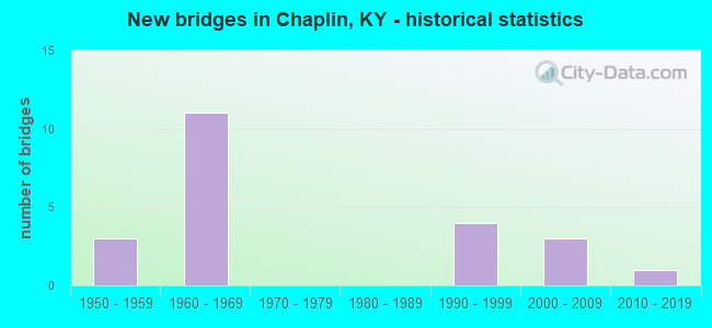
- New bridges - historical statistics
- 31950-1959
- 111960-1969
- 41990-1999
- 32000-2009
- 12010-2019


- Bridge Condition - Deck
- 20.0%Very good
- 40.0%Good
- 26.7%Satisfactory
- 13.3%Fair

- Bridge Condition - Superstructure
- 20.0%Very good
- 46.7%Good
- 20.0%Satisfactory
- 13.3%Fair

- Bridge Condition - Substructure
- 6.7%Very good
- 66.7%Good
- 20.0%Satisfactory
- 6.7%Fair

- Bridge Condition - Channel
- 7.1%Excellent
- 78.6%Good
- 14.3%Satisfactory

- Bridge Condition - Culverts
- 66.7%Good
- 33.3%Satisfactory
Find on map >> Show street view
Structure Number: 90B00019L, Location: WBL on Wash/Nelson Line (Lat: 37.876389, Lng: -85.196111), Route carried "on" structure: State highway 9002, Year Built: 1965, Status: Open, Structure Length: 10.06m (33.01ft), Average Daily Traffic: 5,001 (year 2020), Truck Traffic: 22%, Average Future Daily Traffic: 4,700 (year 2040), Design Load: HS 20, Features Intersected: Chaplin River, Facility Carried by Structure: Bluegrass Parkway
Minimum Vertical Clearance: 30+ m (98+ ft), Kilometerpoint: 63.167, Lanes on structure: 2, Base Highway Network: Yes, Owner: State Highway Agency, Approaching Roadway Width: 10.4m (34.1ft), Skew: 10 degrees, Material/Design: Steel continuous, Design/Construction: Stringer/Multi-beam, Number Of Spans In Main Unit: 3, Length of Maximum Span: 39.6m (129.9ft), Curb-To-Curb Width: 9.1m (29.9ft), Out-to-Out Width: 10.1m (33.1ft)
Condition: Deck: Satisfactory, Superstructure: Good, Substructure: Satisfactory, Channel: Good, Operating Rating: 69.0 metric tons, Method Used To Determine Operating Rating: Load Factor (LF), Inventory Rating: 41.4 metric tons, Method Used To Determine Inventory Rating: Load Factor (LF), Structural Evaluation: Equal to present minimum criteria, Deck Geometry: Meets minimum limits, Waterway Adequacy: Equal to present desirable criteria, Approach Roadway Alignment: Better than present minimum criteria, Designated Inspection Frequency: Every 24 months, Inspection Date: Febuary 2021, Deck Structure Type: Concrete Cast-file-Place, Wearing Surface/Protective System: Deck Protection: Epoxy Coated Reinforcing
Find on map >> Show street view
Structure Number: 90B00019R, Location: EBL on Wash/Nelson Line (Lat: 37.876111, Lng: -85.196111), Route carried "on" structure: State highway 9002, Year Built: 1965, Status: Open, Structure Length: 10.06m (33.01ft), Average Daily Traffic: 5,001 (year 2020), Truck Traffic: 22%, Average Future Daily Traffic: 4,700 (year 2040), Design Load: HS 20, Features Intersected: Chaplin River, Facility Carried by Structure: Bluegrass Parkway
Minimum Vertical Clearance: 30+ m (98+ ft), Kilometerpoint: 63.170, Lanes on structure: 2, Base Highway Network: Yes, Owner: State Highway Agency, Approaching Roadway Width: 10.4m (34.1ft), Skew: 10 degrees, Material/Design: Steel continuous, Design/Construction: Stringer/Multi-beam, Number Of Spans In Main Unit: 3, Length of Maximum Span: 39.6m (129.9ft), Curb-To-Curb Width: 9.1m (29.9ft), Out-to-Out Width: 10.1m (33.1ft)
Condition: Deck: Satisfactory, Superstructure: Satisfactory, Substructure: Satisfactory, Channel: Good, Operating Rating: 69.0 metric tons, Method Used To Determine Operating Rating: Load Factor (LF), Inventory Rating: 41.4 metric tons, Method Used To Determine Inventory Rating: Load Factor (LF), Structural Evaluation: Equal to present minimum criteria, Deck Geometry: Meets minimum limits, Waterway Adequacy: Equal to present desirable criteria, Approach Roadway Alignment: Better than present minimum criteria, Designated Inspection Frequency: Every 24 months, Inspection Date: Febuary 2021, Deck Structure Type: Concrete Cast-file-Place, Wearing Surface/Protective System: Wearing Surface: Monolithic Concrete, Deck Protection: Epoxy Coated Reinforcing
Find on map >> Show street view
Structure Number: 90B00036N, Location: 3 MI E OF KY 55 TOLL PLZA (Lat: 37.883333, Lng: -85.246389), Route carried "on" structure: State highway 2775, Year Built: 1965, Status: Posted for load, Structure Length: 8.17m (26.80ft), Average Daily Traffic: 215 (year 2018), Average Future Daily Traffic: 187 (year 2038), Design Load: H 20, Features Intersected: BLUEGRASS PARKWAY
Minimum Vertical Clearance: 30+ m (98+ ft), Kilometerpoint: 0.214, Lanes on structure: 2, Lanes under structure: 4, Owner: State Highway Agency, Approaching Roadway Width: 4.9m (16.1ft), Skew: 3 degrees, Material/Design: Concrete continuous, Design/Construction: Tee Beam, Number Of Spans In Main Unit: 4, Length of Maximum Span: 21.6m (70.9ft), Curb or Sidewalk Widths: Left: 0.5m (1.6ft), Right: 0.5m (1.6ft), Curb-To-Curb Width: 7.9m (25.9ft), Out-to-Out Width: 8.8m (28.9ft)
Condition: Deck: Satisfactory, Superstructure: Good, Substructure: Good, Operating Rating: 46.5 metric tons, Method Used To Determine Operating Rating: Load Factor (LF), Inventory Rating: 27.9 metric tons, Method Used To Determine Inventory Rating: Load Factor (LF), Structural Evaluation: Better than present minimum criteria, Deck Geometry: Somewhat better than minimum adequacy, Underclear: Equal to present minimum criteria, Approach Roadway Alignment: Equal to present minimum criteria, Bridge Posting: Required (Relationship of Operating Rating to Maximum Legal Load: 10.0 - 19.9% below), Designated Inspection Frequency: Every 24 months, Inspection Date: Febuary 2020, Deck Structure Type: Concrete Cast-file-Place, Wearing Surface/Protective System: Wearing Surface: Latex Concrete
Find on map >> Show street view
Structure Number: 90B00065N, Location: 1.1 MI S OF JCT US 62 (Lat: 37.882778, Lng: -85.223611), Route carried "on" structure: State highway 458, Year Built: 1965, Status: Open, Structure Length: 6.22m (20.41ft), Average Daily Traffic: 438 (year 2020), Average Future Daily Traffic: 385 (year 2040), Design Load: H 20, Features Intersected: BLUEGRASS PW NR CHAPLIN
Minimum Vertical Clearance: 30+ m (98+ ft), Kilometerpoint: 1.722, Lanes on structure: 2, Lanes under structure: 4, Owner: State Highway Agency, Approaching Roadway Width: 4.9m (16.1ft), Material/Design: Concrete, Design/Construction: Tee Beam, Number Of Spans In Main Unit: 4, Length of Maximum Span: 15.5m (50.9ft), Curb or Sidewalk Widths: Left: 0.5m (1.6ft), Right: 0.5m (1.6ft), Curb-To-Curb Width: 9.1m (29.9ft), Out-to-Out Width: 10.1m (33.1ft)
Condition: Deck: Satisfactory, Superstructure: Satisfactory, Substructure: Satisfactory, Operating Rating: 53.8 metric tons, Method Used To Determine Operating Rating: Load Factor (LF), Inventory Rating: 32.3 metric tons, Method Used To Determine Inventory Rating: Load Factor (LF), Structural Evaluation: Equal to present minimum criteria, Deck Geometry: Equal to present minimum criteria, Underclear: Meets minimum limits, Approach Roadway Alignment: Better than present minimum criteria, Designated Inspection Frequency: Every 24 months, Inspection Date: Febuary 2021, Deck Structure Type: Concrete Cast-file-Place, Wearing Surface/Protective System: Wearing Surface: Latex Concrete
Find on map >> Show street view
Structure Number: 90B00073N, Location: .05 MI SW OF JCT KY 1873 (Lat: 37.937778, Lng: -85.246389), Route carried "on" structure: State highway 1066, Year Built: 1951, Status: Posted for load, Structure Length: 2.32m (7.61ft), Average Daily Traffic: 314 (year 2018), Average Future Daily Traffic: 273 (year 2038), Design Load: H 15, Features Intersected: ASHES CREEK
Minimum Vertical Clearance: 30+ m (98+ ft), Kilometerpoint: 5.927, Lanes on structure: 2, Owner: State Highway Agency, Approaching Roadway Width: 5.5m (18.0ft), Skew: 4 degrees, Material/Design: Concrete, Design/Construction: Tee Beam, Number Of Spans In Main Unit: 2, Length of Maximum Span: 10.7m (35.1ft), Curb-To-Curb Width: 7.3m (24.0ft), Out-to-Out Width: 7.9m (25.9ft)
Condition: Deck: Fair, Superstructure: Fair, Substructure: Fair, Channel: Satisfactory, Operating Rating: 42.6 metric tons, Method Used To Determine Operating Rating: Load Factor (LF), Inventory Rating: 25.6 metric tons, Method Used To Determine Inventory Rating: Load Factor (LF), Structural Evaluation: Somewhat better than minimum adequacy, Deck Geometry: Somewhat better than minimum adequacy, Waterway Adequacy: Equal to present minimum criteria, Approach Roadway Alignment: Equal to present minimum criteria, Bridge Posting: Required (Relationship of Operating Rating to Maximum Legal Load: 30.0 - 39.9% below), Designated Inspection Frequency: Every 24 months, Inspection Date: Febuary 2021, Deck Structure Type: Concrete Cast-file-Place, Wearing Surface/Protective System: Wearing Surface: Latex Concrete
Find on map >> Show street view
Structure Number: 90B00075N, Location: .80 MI EAST OF JCT KY 458 (Lat: 37.926667, Lng: -85.255556), Route carried "on" structure: State highway 1066, Year Built: 1951, Status: Open, Structure Length: 0.82m (2.69ft), Average Daily Traffic: 314 (year 2018), Average Future Daily Traffic: 273 (year 2038), Design Load: H 15, Features Intersected: HUNTERS CREEK
Minimum Vertical Clearance: 30+ m (98+ ft), Kilometerpoint: 4.324, Lanes on structure: 2, Owner: State Highway Agency, Approaching Roadway Width: 8.2m (26.9ft), Skew: 3 degrees, Material/Design: Concrete, Design/Construction: Culvert, Number Of Spans In Main Unit: 2, Length of Maximum Span: 3.7m (12.1ft)
Condition: Channel: Good, Culverts: Good, Operating Rating: 54.4 metric tons, Method Used To Determine Operating Rating: Field evaluation and documented engineering judgment, Inventory Rating: 39.9 metric tons, Method Used To Determine Inventory Rating: Field evaluation and documented engineering judgment, Structural Evaluation: Better than present minimum criteria, Waterway Adequacy: Equal to present minimum criteria, Approach Roadway Alignment: Equal to present minimum criteria, Designated Inspection Frequency: Every 24 months, Inspection Date: Febuary 2021
Find on map >> Show street view
Structure Number: 90B00076N, Location: .1 MI N OF JCT KY 1873 (Lat: 37.940833, Lng: -85.247500), Route carried "on" structure: State highway 1066, Year Built: 1951, Status: Open, Structure Length: 0.82m (2.69ft), Average Daily Traffic: 314 (year 2018), Average Future Daily Traffic: 273 (year 2038), Design Load: H 15, Features Intersected: BR OF ASHES CREEK
Minimum Vertical Clearance: 30+ m (98+ ft), Kilometerpoint: 6.293, Lanes on structure: 2, Owner: State Highway Agency, Approaching Roadway Width: 4.9m (16.1ft), Skew: 4 degrees, Material/Design: Concrete, Design/Construction: Culvert, Number Of Spans In Main Unit: 2, Length of Maximum Span: 3.4m (11.2ft)
Condition: Channel: Satisfactory, Culverts: Good, Operating Rating: 76.7 metric tons, Method Used To Determine Operating Rating: Load Factor (LF), Inventory Rating: 46.0 metric tons, Method Used To Determine Inventory Rating: Load Factor (LF), Structural Evaluation: Better than present minimum criteria, Waterway Adequacy: Better than present minimum criteria, Approach Roadway Alignment: Equal to present minimum criteria, Designated Inspection Frequency: Every 24 months, Inspection Date: Febuary 2020
Find on map >> Show street view
Structure Number: 90B00092N, Location: .7 MI SE OF JCT KY 1066 (Lat: 37.930000, Lng: -85.236667), Route carried "on" structure: State highway 1873, Year Built: 1961, Status: Posted for load, Structure Length: 1.34m (4.40ft), Average Daily Traffic: 155 (year 2018), Average Future Daily Traffic: 134 (year 2038), Design Load: H 15, Features Intersected: ASHES CREEK
Minimum Vertical Clearance: 30+ m (98+ ft), Kilometerpoint: 3.639, Lanes on structure: 2, Owner: State Highway Agency, Approaching Roadway Width: 5.2m (17.1ft), Skew: 3 degrees, Material/Design: Concrete, Design/Construction: Culvert, Number Of Spans In Main Unit: 3, Length of Maximum Span: 4.3m (14.1ft), Curb-To-Curb Width: 5.5m (18.0ft), Out-to-Out Width: 15.2m (49.9ft)
Condition: Channel: Good, Culverts: Satisfactory, Operating Rating: 20.0 metric tons, Method Used To Determine Operating Rating: Field evaluation and documented engineering judgment, Inventory Rating: 20.0 metric tons, Method Used To Determine Inventory Rating: Field evaluation and documented engineering judgment, Structural Evaluation: Somewhat better than minimum adequacy, Deck Geometry: High priority of corrective action, Waterway Adequacy: Equal to present minimum criteria, Approach Roadway Alignment: Equal to present minimum criteria, Bridge Posting: Required (Relationship of Operating Rating to Maximum Legal Load: > 39.9% below), Designated Inspection Frequency: Every 24 months, Inspection Date: Febuary 2020
Find on map >> Show street view
Structure Number: 90B00110N, Location: AT NELSON-WASH.CO LINE (Lat: 37.891111, Lng: -85.199444), Route carried "on" structure: State highway 1754, Year Built: 1990, Status: Open, Structure Length: 7.10m (23.29ft), Average Daily Traffic: 390 (year 2020), Average Future Daily Traffic: 343 (year 2040), Design Load: HS 25 or greater, Features Intersected: CHAPLIN RIVER
Minimum Vertical Clearance: 30+ m (98+ ft), Kilometerpoint: 0.023, Lanes on structure: 2, Owner: State Highway Agency, Approaching Roadway Width: 7.9m (25.9ft), Material/Design: Prestressed concrete continuous, Design/Construction: Stringer/Multi-beam, Number Of Spans In Main Unit: 3, Length of Maximum Span: 30.5m (100.1ft), Curb-To-Curb Width: 7.9m (25.9ft), Out-to-Out Width: 8.9m (29.2ft)
Condition: Deck: Very good, Superstructure: Very good, Substructure: Very good, Channel: Good, Operating Rating: 83.6 metric tons, Method Used To Determine Operating Rating: Load Factor (LF), Inventory Rating: 50.2 metric tons, Method Used To Determine Inventory Rating: Load Factor (LF), Structural Evaluation: Equal to present desirable criteria, Deck Geometry: Somewhat better than minimum adequacy, Waterway Adequacy: Better than present minimum criteria, Approach Roadway Alignment: Equal to present minimum criteria, Designated Inspection Frequency: Every 24 months, Inspection Date: Febuary 2020, Deck Structure Type: Concrete Cast-file-Place, Wearing Surface/Protective System: Wearing Surface: Monolithic Concrete, Deck Protection: Epoxy Coated Reinforcing
Find on map >> Show street view
Structure Number: 90B00118N, Location: Nelson/Washington Line (Lat: 37.870556, Lng: -85.230833), Route carried "on" structure: State highway 458, Year Built: 2013, Status: Open, Structure Length: 8.96m (29.40ft), Average Daily Traffic: 438 (year 2020), Average Future Daily Traffic: 385 (year 2040), Design Load: Greater than HL93, Features Intersected: Chaplin River
Minimum Vertical Clearance: 30+ m (98+ ft), Kilometerpoint: 0.019, Lanes on structure: 2, Owner: State Highway Agency, Approaching Roadway Width: 5.5m (18.0ft), Material/Design: Prestressed concrete continuous, Design/Construction: Stringer/Multi-beam, Number Of Spans In Main Unit: 4, Length of Maximum Span: 22.3m (73.2ft), Curb-To-Curb Width: 6.0m (19.7ft), Out-to-Out Width: 6.9m (22.6ft)
Condition: Deck: Very good, Superstructure: Very good, Substructure: Good, Channel: Good, Operating Rating: 55.4 metric tons, Method Used To Determine Operating Rating: Load and Resistance Factor Rating (LRFR) rating reported by rating factor(RF) method using HL-93 loadings, Inventory Rating: 42.8 metric tons, Method Used To Determine Inventory Rating: Load and Resistance Factor Rating (LRFR) rating reported by rating factor(RF) method using HL-93 loadings, Structural Evaluation: Better than present minimum criteria, Deck Geometry: High priority of replacement, Waterway Adequacy: Equal to present desirable criteria, Approach Roadway Alignment: Somewhat better than minimum adequacy, Designated Inspection Frequency: Every 24 months, Inspection Date: Febuary 2020, Deck Structure Type: Concrete Cast-file-Place, Wearing Surface/Protective System: Wearing Surface: Monolithic Concrete, Deck Protection: Epoxy Coated Reinforcing
Find on map >> Show street view
Structure Number: 90C00046N, Location: .2 MI NW JCT KY 458 (Lat: 37.875833, Lng: -85.233056), Route carried "on" structure: County highway 1024, Year Built: 1991, Status: Open, Structure Length: 1.83m (6.00ft), Average Daily Traffic: 215 (year 2018), Average Future Daily Traffic: 187 (year 2038), Design Load: HS 25 or greater, Features Intersected: JESSIE RUN, Facility Carried by Structure: MURPHY LN
Minimum Vertical Clearance: 30+ m (98+ ft), Kilometerpoint: 0.198, Lanes on structure: 2, Owner: County Highway Agency, Approaching Roadway Width: 5.5m (18.0ft), Skew: 4 degrees, Material/Design: Prestressed concrete, Design/Construction: Box Beam or Girders - Multiple, Number Of Spans In Main Unit: 1, Length of Maximum Span: 17.7m (58.1ft), Curb-To-Curb Width: 6.9m (22.6ft), Out-to-Out Width: 7.3m (24.0ft)
Condition: Deck: Good, Superstructure: Good, Substructure: Good, Channel: Good, Operating Rating: 59.3 metric tons, Method Used To Determine Operating Rating: Load Factor (LF), Inventory Rating: 35.6 metric tons, Method Used To Determine Inventory Rating: Load Factor (LF), Structural Evaluation: Better than present minimum criteria, Deck Geometry: Meets minimum limits, Waterway Adequacy: Better than present minimum criteria, Approach Roadway Alignment: Somewhat better than minimum adequacy, Designated Inspection Frequency: Every 24 months, Inspection Date: July 2020, Deck Structure Type: Concrete Precast Panels, Wearing Surface/Protective System: Wearing Surface: Monolithic Concrete
Find on map >> Show street view
Structure Number: 90C00051N, Location: 1.5 MI N. US 62 (Lat: 37.937500, Lng: -85.204167), Route carried "on" structure: Ramp County highway 1044, Year Built: 1992, Status: Posted for load, Structure Length: 0.91m (2.99ft), Average Daily Traffic: 14 (year 2006), Average Future Daily Traffic: 21 (year 2026), Features Intersected: TIMBER CREEK, Facility Carried by Structure: DRAKE LN X
Minimum Vertical Clearance: 30+ m (98+ ft), Kilometerpoint: 0.296, Lanes on structure: 1, Owner: County Highway Agency, Approaching Roadway Width: 6.1m (20.0ft), Material/Design: Steel, Design/Construction: Stringer/Multi-beam, Number Of Spans In Main Unit: 1, Length of Maximum Span: 8.5m (27.9ft), Curb or Sidewalk Widths: Left: 0.2m (0.7ft), Right: 0.2m (0.7ft), Curb-To-Curb Width: 3.3m (10.8ft), Out-to-Out Width: 3.6m (11.8ft)
Condition: Deck: Good, Superstructure: Satisfactory, Substructure: Good, Channel: Good, Operating Rating: 42.4 metric tons, Method Used To Determine Operating Rating: Load Factor (LF), Inventory Rating: 25.4 metric tons, Method Used To Determine Inventory Rating: Load Factor (LF), Structural Evaluation: Equal to present minimum criteria, Deck Geometry: High priority of replacement, Waterway Adequacy: Equal to present minimum criteria, Approach Roadway Alignment: Meets minimum limits, Bridge Posting: Required (Relationship of Operating Rating to Maximum Legal Load: > 39.9% below), Length Of Structure Improvement: 0.09m (0.30ft), Designated Inspection Frequency: Every 24 months, Inspection Date: July 2021, Bridge Improvement Cost: $45,000, Total Project Cost: $44,000, Deck Structure Type: Concrete Cast-file-Place, Wearing Surface/Protective System: Wearing Surface: Monolithic Concrete
Find on map >> Show street view
Structure Number: 90C00059N, Location: 0.8 Miles N JCT US 62 (Lat: 37.928889, Lng: -85.191944), Route carried "on" structure: County highway 1035, Year Built: 1996, Status: Posted for load, Structure Length: 0.85m (2.79ft), Average Daily Traffic: 319 (year 2010), Average Future Daily Traffic: 277 (year 2030), Design Load: HS 25 or greater, Features Intersected: TIMBER CREEK, Facility Carried by Structure: GREEN CHAPEL RD
Minimum Vertical Clearance: 30+ m (98+ ft), Kilometerpoint: 1.452, Lanes on structure: 2, Owner: County Highway Agency, Approaching Roadway Width: 6.1m (20.0ft), Skew: 3 degrees, Material/Design: Prestressed concrete, Design/Construction: Box Beam or Girders - Multiple, Number Of Spans In Main Unit: 1, Length of Maximum Span: 8.2m (26.9ft), Curb-To-Curb Width: 6.9m (22.6ft), Out-to-Out Width: 7.5m (24.6ft)
Condition: Deck: Good, Superstructure: Very good, Substructure: Good, Channel: Good, Operating Rating: 38.0 metric tons, Method Used To Determine Operating Rating: Load Factor (LF), Inventory Rating: 22.8 metric tons, Method Used To Determine Inventory Rating: Load Factor (LF), Structural Evaluation: Equal to present minimum criteria, Deck Geometry: Meets minimum limits, Waterway Adequacy: Equal to present minimum criteria, Approach Roadway Alignment: Equal to present minimum criteria, Bridge Posting: Required (Relationship of Operating Rating to Maximum Legal Load: > 39.9% below), Designated Inspection Frequency: Every 24 months, Inspection Date: July 2021, Deck Structure Type: Concrete Precast Panels, Wearing Surface/Protective System: Wearing Surface: Monolithic Concrete, Deck Protection: Epoxy Coated Reinforcing
Find on map >> Show street view
Structure Number: 90C00069N, Location: 0.03 Mi E of Jct CR1036 (Lat: 37.957778, Lng: -85.198611), Route carried "on" structure: County highway 1034, Year Built: 2007, Status: Open, Structure Length: 2.01m (6.59ft), Average Daily Traffic: 279 (year 2010), Average Future Daily Traffic: 242 (year 2030), Design Load: HS 25 or greater, Features Intersected: Timber Creek, Facility Carried by Structure: Highview Church
Minimum Vertical Clearance: 30+ m (98+ ft), Kilometerpoint: 1.353, Lanes on structure: 2, Owner: County Highway Agency, Approaching Roadway Width: 4.9m (16.1ft), Skew: 1 degrees, Material/Design: Prestressed concrete, Design/Construction: Box Beam or Girders - Multiple, Number Of Spans In Main Unit: 1, Length of Maximum Span: 19.5m (64.0ft), Curb-To-Curb Width: 6.9m (22.6ft), Out-to-Out Width: 7.3m (24.0ft)
Condition: Deck: Good, Superstructure: Good, Substructure: Good, Channel: Excellent, Operating Rating: 79.9 metric tons, Method Used To Determine Operating Rating: Load Factor (LF), Inventory Rating: 48.0 metric tons, Method Used To Determine Inventory Rating: Load Factor (LF), Structural Evaluation: Better than present minimum criteria, Deck Geometry: Meets minimum limits, Waterway Adequacy: Equal to present minimum criteria, Approach Roadway Alignment: Equal to present minimum criteria, Designated Inspection Frequency: Every 24 months, Inspection Date: July 2021, Deck Structure Type: Concrete Precast Panels, Wearing Surface/Protective System: Wearing Surface: Monolithic Concrete, Deck Protection: Epoxy Coated Reinforcing
Find on map >> Show street view
Structure Number: 90C00071N, Location: 0.7 Mi. North of US 62 (Lat: 37.926944, Lng: -85.192222), Route carried "on" structure: County highway 1035, Year Built: 2009, Status: Open, Structure Length: 0.76m (2.49ft), Average Daily Traffic: 199 (year 2011), Average Future Daily Traffic: 298 (year 2031), Features Intersected: Timber Creek, Facility Carried by Structure: Greens Chapel Rd.
Minimum Vertical Clearance: 30.18m (99.02ft), Kilometerpoint: 1.234, Lanes on structure: 2, Owner: County Highway Agency, Approaching Roadway Width: 5.2m (17.1ft), Skew: 3 degrees, Material/Design: Steel, Design/Construction: Stringer/Multi-beam, Number Of Spans In Main Unit: 1, Length of Maximum Span: 6.7m (22.0ft), Curb or Sidewalk Widths: Left: 0.2m (0.7ft), Right: 0.2m (0.7ft), Curb-To-Curb Width: 5.9m (19.4ft), Out-to-Out Width: 6.4m (21.0ft)
Condition: Deck: Good, Superstructure: Good, Substructure: Good, Channel: Good, Operating Rating: 80.4 metric tons, Method Used To Determine Operating Rating: Load Factor (LF), Inventory Rating: 48.3 metric tons, Method Used To Determine Inventory Rating: Load Factor (LF), Structural Evaluation: Better than present minimum criteria, Deck Geometry: High priority of corrective action, Waterway Adequacy: Somewhat better than minimum adequacy, Approach Roadway Alignment: Equal to present minimum criteria, Designated Inspection Frequency: Every 24 months, Inspection Date: July 2021, Deck Structure Type: Concrete Cast-file-Place, Wearing Surface/Protective System: Wearing Surface: Monolithic Concrete
Find on map >> Show street view
Structure Number: 115B00010N, Location: OVER BG PW INTERCHANGE (Lat: 37.870556, Lng: -85.158889), Route carried "on" structure: State highway 555, Year Built: 1968, Status: Open, Structure Length: 5.94m (19.49ft), Average Daily Traffic: 4,369 (year 2019), Truck Traffic: 20%, Average Future Daily Traffic: 4,106 (year 2039), Design Load: H 20, Features Intersected: BLUEGRASS PARKWAY
Minimum Vertical Clearance: 30+ m (98+ ft), Kilometerpoint: 23.591, Lanes on structure: 2, Lanes under structure: 4, Base Highway Network: Yes, Owner: State Highway Agency, Approaching Roadway Width: 7.3m (24.0ft), Skew: 22 degrees, Material/Design: Prestressed concrete continuous, Design/Construction: Stringer/Multi-beam, Number Of Spans In Main Unit: 4, Length of Maximum Span: 17.7m (58.1ft), Curb or Sidewalk Widths: Left: 0.5m (1.6ft), Right: 0.5m (1.6ft), Curb-To-Curb Width: 9.1m (29.9ft), Out-to-Out Width: 10.1m (33.1ft)
Condition: Deck: Good, Superstructure: Good, Substructure: Good, Operating Rating: 83.3 metric tons, Method Used To Determine Operating Rating: Load Factor (LF), Inventory Rating: 50.0 metric tons, Method Used To Determine Inventory Rating: Load Factor (LF), Structural Evaluation: Better than present minimum criteria, Deck Geometry: Meets minimum limits, Underclear: Somewhat better than minimum adequacy, Approach Roadway Alignment: Equal to present minimum criteria, Designated Inspection Frequency: Every 24 months, Inspection Date: March 2020, Deck Structure Type: Concrete Cast-file-Place, Wearing Surface/Protective System: Wearing Surface: Latex Concrete
Find on map >> Show street view
Structure Number: 115B00037N, Location: .5 MI W OF JCT KY 555 (Lat: 37.870833, Lng: -85.167778), Route carried "on" structure: State highway 1754, Year Built: 1964, Status: Posted for load, Structure Length: 7.49m (24.57ft), Average Daily Traffic: 247 (year 2018), Average Future Daily Traffic: 217 (year 2038), Design Load: H 20, Features Intersected: BLUEGRASS PARKWAY
Minimum Vertical Clearance: 30+ m (98+ ft), Kilometerpoint: 8.454, Lanes on structure: 2, Lanes under structure: 4, Owner: State Highway Agency, Approaching Roadway Width: 5.5m (18.0ft), Skew: 3 degrees, Material/Design: Concrete continuous, Design/Construction: Tee Beam, Number Of Spans In Main Unit: 4, Length of Maximum Span: 21.3m (69.9ft), Curb or Sidewalk Widths: Left: 0.5m (1.6ft), Right: 0.5m (1.6ft), Curb-To-Curb Width: 7.9m (25.9ft), Out-to-Out Width: 9.4m (30.8ft)
Condition: Deck: Fair, Superstructure: Fair, Substructure: Good, Operating Rating: 45.0 metric tons, Method Used To Determine Operating Rating: Load Factor (LF), Inventory Rating: 26.9 metric tons, Method Used To Determine Inventory Rating: Load Factor (LF), Structural Evaluation: Somewhat better than minimum adequacy, Deck Geometry: Somewhat better than minimum adequacy, Underclear: Somewhat better than minimum adequacy, Approach Roadway Alignment: Somewhat better than minimum adequacy, Bridge Posting: Required (Relationship of Operating Rating to Maximum Legal Load: 30.0 - 39.9% below), Designated Inspection Frequency: Every 24 months, Inspection Date: March 2021, Deck Structure Type: Concrete Cast-file-Place, Wearing Surface/Protective System: Wearing Surface: Latex Concrete
Find on map >> Show street view
Structure Number: 115B00065N, Location: Nelson/Washington Co line (Lat: 37.885556, Lng: -85.155000), Route carried "on" structure: State highway 555, Year Built: 2007, Status: Open, Structure Length: 20.82m (68.31ft), Average Daily Traffic: 1,025 (year 2019), Truck Traffic: 18%, Average Future Daily Traffic: 902 (year 2039), Design Load: HS 25 or greater, Features Intersected: Chaplin River
Minimum Vertical Clearance: 30+ m (98+ ft), Kilometerpoint: 25.255, Lanes on structure: 2, Owner: State Highway Agency, Approaching Roadway Width: 12.2m (40.0ft), Material/Design: Prestressed concrete continuous, Design/Construction: Stringer/Multi-beam, Number Of Spans In Main Unit: 5, Length of Maximum Span: 45.1m (148.0ft), Curb-To-Curb Width: 12.2m (40.0ft), Out-to-Out Width: 13.1m (43.0ft)
Condition: Deck: Very good, Superstructure: Good, Substructure: Good, Channel: Good, Operating Rating: 83.7 metric tons, Method Used To Determine Operating Rating: Load Factor (LF), Inventory Rating: 50.3 metric tons, Method Used To Determine Inventory Rating: Load Factor (LF), Structural Evaluation: Better than present minimum criteria, Deck Geometry: Better than present minimum criteria, Waterway Adequacy: Superior to present desirable criteria, Approach Roadway Alignment: Equal to present minimum criteria, Designated Inspection Frequency: Every 24 months, Inspection Date: March 2021, Deck Structure Type: Concrete Cast-file-Place, Wearing Surface/Protective System: Wearing Surface: Monolithic Concrete, Deck Protection: Epoxy Coated Reinforcing
Find on map >> Show street view
Structure Number: 90B00036N, Location: 3 MI E OF KY 55 TOLL PLZA (Lat: 37.883333, Lng: -85.246389), Route carried "under" structure: State highway 9002, Year Built: 1965, Structure Length: 0. m, Average Daily Traffic: 10,001 (year 2020), Truck Traffic: 22%, Features Intersected: BLUEGRASS PARKWAY, Facility Carried by Structure: KY-2775
Minimum Vertical Clearance: 5.89m (19.32ft), Kilometerpoint: 58.574, Lanes on structure: 2, Lanes under structure: 4, Material/Design: Concrete continuous, Design/Construction: Tee Beam, Length of Maximum Span: 21.6m (70.9ft)
Find on map >> Show street view
Structure Number: 90B00065N, Location: 1.1 MI S OF JCT US 62 (Lat: 37.882778, Lng: -85.223611), Route carried "under" structure: State highway 9002, Year Built: 1965, Structure Length: 0. m, Average Daily Traffic: 10,001 (year 2020), Truck Traffic: 22%, Features Intersected: BLUEGRASS PW NR CHAPLIN, Facility Carried by Structure: KY-458
Minimum Vertical Clearance: 6.22m (20.41ft), Kilometerpoint: 60.584, Lanes on structure: 2, Lanes under structure: 4, Material/Design: Concrete, Design/Construction: Tee Beam, Length of Maximum Span: 15.5m (50.9ft)
Find on map >> Show street view
Structure Number: 115B00010N, Location: OVER BG PW INTERCHANGE (Lat: 37.870556, Lng: -85.158889), Route carried "under" structure: State highway 9002, Year Built: 1968, Structure Length: 0. m, Average Daily Traffic: 12,942 (year 2020), Features Intersected: BLUEGRASS PARKWAY, Facility Carried by Structure: KY-555
Minimum Vertical Clearance: 5.06m (16.60ft), Kilometerpoint: 66.628, Lanes on structure: 2, Lanes under structure: 4, Material/Design: Prestressed concrete continuous, Design/Construction: Stringer/Multi-beam, Length of Maximum Span: 17.7m (58.1ft)
Find on map >> Show street view
Structure Number: 115B00037N, Location: .5 MI W OF JCT KY 555 (Lat: 37.870833, Lng: -85.167778), Route carried "under" structure: State highway 9002, Year Built: 1964, Structure Length: 0. m, Average Daily Traffic: 10,001 (year 2020), Truck Traffic: 22%, Features Intersected: BLUEGRASS PARKWAY, Facility Carried by Structure: KY-1754
Minimum Vertical Clearance: 5.11m (16.77ft), Kilometerpoint: 65.830, Lanes on structure: 2, Lanes under structure: 4, Material/Design: Concrete continuous, Design/Construction: Tee Beam, Length of Maximum Span: 21.3m (69.9ft)