Bridge Statistics for Charlestown, Maryland (MD)
Condition, Traffic, Stress, Structural Evaluation, Project Costs
- National Bridge Inventory (NBI) Statistics
- 10Number of bridges
- 98ft / 29.7mTotal length
- $257,000Total costs
- 94,086Total average daily traffic
- 10,427Total average daily truck traffic
- 131,226Total future (year 2026) average daily traffic
- National Bridge Inventory (NBI) Registered Bridges for Charlestown
- No street view available for this location
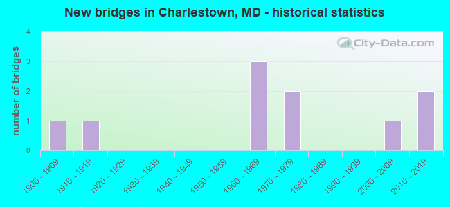
- New bridges - historical statistics
- 11900-1909
- 11910-1919
- 31960-1969
- 21970-1979
- 12000-2009
- 22010-2019


- Bridge Condition - Deck
- 25.0%Very good
- 37.5%Satisfactory
- 37.5%Fair

- Bridge Condition - Superstructure
- 11.1%Excellent
- 11.1%Very good
- 22.2%Good
- 33.3%Satisfactory
- 22.2%Fair

- Bridge Condition - Substructure
- 11.1%Very good
- 33.3%Good
- 33.3%Satisfactory
- 22.2%Fair

- Bridge Condition - Channel
- 40.0%Very good
- 20.0%Good
- 20.0%Satisfactory
- 20.0%Fair
Find on map >> Show street view
Structure Number: 10000007002901, Location: 0.06 MILE EAST OF MD 7C (Lat: 39.575444, Lng: -75.993167), Route carried "on" structure: State highway 267, Year Built: 1967, Status: Open, Structure Length: 5.70m (18.70ft), Average Daily Traffic: 1,680 (year 2009), Truck Traffic: 8%, Average Future Daily Traffic: 2,156 (year 2026), Design Load: HS 20, Features Intersected: AMTRAK
Minimum Vertical Clearance: 30+ m (98+ ft), Kilometerpoint: 0.069, Lanes on structure: 2, Owner: State Highway Agency, Approaching Roadway Width: 13.4m (44.0ft), Skew: 2 degrees, Material/Design: Steel, Design/Construction: Stringer/Multi-beam, Number Of Spans In Main Unit: 3, Length of Maximum Span: 27.4m (89.9ft), Curb or Sidewalk Widths: Left: 0.9m (3.0ft), Right: 0.9m (3.0ft), Curb-To-Curb Width: 9.1m (29.9ft), Out-to-Out Width: 11.6m (38.1ft)
Condition: Deck: Satisfactory, Superstructure: Satisfactory, Substructure: Good, Operating Rating: 63.5 metric tons, Method Used To Determine Operating Rating: Load Factor (LF), Inventory Rating: 38.1 metric tons, Method Used To Determine Inventory Rating: Load Factor (LF), Structural Evaluation: Equal to present minimum criteria, Deck Geometry: Somewhat better than minimum adequacy, Underclear: Better than present minimum criteria, Approach Roadway Alignment: Equal to present desirable criteria, Designated Inspection Frequency: Every 24 months, Inspection Date: June 2021, Deck Structure Type: Concrete Cast-file-Place, Wearing Surface/Protective System: Wearing Surface: Bituminous, Membrane: Other
Find on map >> Show street view
Structure Number: 10000007003001, Location: 0.19 M W OF MARKET STREET (Lat: 39.573614, Lng: -75.979097), Route carried "on" structure: State highway 267, Year Built: 1915, Status: Open, Structure Length: 0.70m (2.30ft), Average Daily Traffic: 1,680 (year 2009), Truck Traffic: 8%, Average Future Daily Traffic: 2,156 (year 2026), Features Intersected: RED RUM RUN
Minimum Vertical Clearance: 30+ m (98+ ft), Kilometerpoint: 1.496, Lanes on structure: 2, Owner: State Highway Agency, Approaching Roadway Width: 5.5m (18.0ft), Material/Design: Concrete, Design/Construction: Tee Beam, Number Of Spans In Main Unit: 1, Length of Maximum Span: 6.1m (20.0ft), Curb-To-Curb Width: 6.7m (22.0ft), Out-to-Out Width: 7.3m (24.0ft)
Condition: Deck: Fair, Superstructure: Fair, Substructure: Satisfactory, Channel: Satisfactory, Inventory Rating: 56.7 metric tons, Method Used To Determine Inventory Rating: Load Factor (LF), Structural Evaluation: Somewhat better than minimum adequacy, Deck Geometry: High priority of corrective action, Waterway Adequacy: Equal to present minimum criteria, Approach Roadway Alignment: Equal to present desirable criteria, Length Of Structure Improvement: 0.70m (2.30ft), Designated Inspection Frequency: Every 24 months, Inspection Date: July 2021, Bridge Improvement Cost: $33,000, Roadway Improvement Cost: $3,000, Total Project Cost: $36,000, Deck Structure Type: Concrete Cast-file-Place, Wearing Surface/Protective System: Wearing Surface: Bituminous
Find on map >> Show street view
Structure Number: 10000007003101, Location: 0.12 MILE WEST OF MD 7C (Lat: 39.582083, Lng: -75.970889), Route carried "on" structure: State highway 267, Year Built: 1974, Status: Open, Structure Length: 6.77m (22.21ft), Average Daily Traffic: 1,680 (year 2009), Truck Traffic: 8%, Average Future Daily Traffic: 2,156 (year 2026), Design Load: HS 20, Features Intersected: AMTRAK
Minimum Vertical Clearance: 30+ m (98+ ft), Kilometerpoint: 2.864, Lanes on structure: 2, Owner: State Highway Agency, Approaching Roadway Width: 11.6m (38.1ft), Skew: 2 degrees, Material/Design: Steel, Design/Construction: Stringer/Multi-beam, Number Of Spans In Main Unit: 3, Length of Maximum Span: 29.9m (98.1ft), Curb or Sidewalk Widths: Left: 1.6m (5.2ft), Right: 0.0m, Curb-To-Curb Width: 9.1m (29.9ft), Out-to-Out Width: 11.5m (37.7ft)
Condition: Deck: Fair, Superstructure: Satisfactory, Substructure: Satisfactory, Inventory Rating: 68.5 metric tons, Method Used To Determine Inventory Rating: Load Factor (LF), Structural Evaluation: Equal to present minimum criteria, Deck Geometry: Somewhat better than minimum adequacy, Underclear: Better than present minimum criteria, Approach Roadway Alignment: Equal to present desirable criteria, Designated Inspection Frequency: Every 24 months, Inspection Date: November 2020, Deck Structure Type: Concrete Cast-file-Place, Wearing Surface/Protective System: Wearing Surface: Monolithic Concrete
Find on map >> Show street view
Structure Number: 10000007006503, Location: 0.63 MILE NORTH OF MD 267 (Lat: 39.592342, Lng: -75.970947), Route carried "on" structure: State highway 7C, Year Built: 1900, Status: Open, Structure Length: 0.69m (2.26ft), Average Daily Traffic: 2,360 (year 2009), Truck Traffic: 8%, Average Future Daily Traffic: 2,617 (year 2026), Features Intersected: BR OF NORTHEAST CREEK
Minimum Vertical Clearance: 30+ m (98+ ft), Kilometerpoint: 5.117, Lanes on structure: 2, Owner: State Highway Agency, Approaching Roadway Width: 8.5m (27.9ft), Material/Design: Steel, Design/Construction: Culvert, Length of Maximum Span: 1.5m (4.9ft)
Condition: Channel: Fair, Culverts: Satisfactory, Operating Rating: 32.7 metric tons, Method Used To Determine Operating Rating: Field evaluation and documented engineering judgment, Inventory Rating: 32.7 metric tons, Method Used To Determine Inventory Rating: Field evaluation and documented engineering judgment, Structural Evaluation: Equal to present minimum criteria, Waterway Adequacy: Equal to present minimum criteria, Approach Roadway Alignment: Equal to present desirable criteria, Designated Inspection Frequency: Every 24 months, Inspection Date: July 2020
Find on map >> Show street view
Structure Number: 200000CE004001, Location: 0.67 MI S OF IS 95 (Lat: 39.614011, Lng: -75.984633), Route carried "on" structure: County highway 79, Year Built: 1973, Status: Open, Structure Length: 4.05m (13.29ft), Average Daily Traffic: 2,810 (year 2016), Truck Traffic: 5%, Average Future Daily Traffic: 4,350 (year 2038), Design Load: HS 20, Features Intersected: CSX RAILROAD, Facility Carried by Structure: RED TOAD ROAD
Minimum Vertical Clearance: 30+ m (98+ ft), Kilometerpoint: 7.820, Lanes on structure: 2, Owner: County Highway Agency, Approaching Roadway Width: 6.1m (20.0ft), Skew: 3 degrees, Material/Design: Prestressed concrete, Design/Construction: Box Beam or Girders - Multiple, Number Of Spans In Main Unit: 3, Length of Maximum Span: 14.0m (45.9ft), Curb-To-Curb Width: 6.6m (21.7ft), Out-to-Out Width: 7.6m (24.9ft)
Condition: Deck: Fair, Superstructure: Fair, Substructure: Fair, Operating Rating: 65.3 metric tons, Method Used To Determine Operating Rating: Load Factor (LF), Inventory Rating: 39.0 metric tons, Method Used To Determine Inventory Rating: Load Factor (LF), Structural Evaluation: Somewhat better than minimum adequacy, Deck Geometry: High priority of replacement, Underclear: Meets minimum limits, Approach Roadway Alignment: Equal to present minimum criteria, Length Of Structure Improvement: 4.08m (13.39ft), Designated Inspection Frequency: Every 24 months, Inspection Date: August 2020, Bridge Improvement Cost: $201,000, Roadway Improvement Cost: $20,000, Total Project Cost: $221,000, Wearing Surface/Protective System: Wearing Surface: Bituminous
Find on map >> Show street view
Structure Number: 200000CE007501, Location: 0.65 MI N of Turkey Point (Lat: 39.520500, Lng: -75.942250), Route carried "on" structure: County highway 204, Year Built: 2015, Status: Open, Structure Length: 0.75m (2.46ft), Average Daily Traffic: 1,710 (year 2022), Truck Traffic: 9%, Average Future Daily Traffic: 2,310 (year 2042), Features Intersected: PINEY CREEK, Facility Carried by Structure: OLD ELK NECK ROAD
Minimum Vertical Clearance: 30+ m (98+ ft), Kilometerpoint: 12.985, Lanes on structure: 2, Owner: County Highway Agency, Approaching Roadway Width: 7.9m (25.9ft), Skew: 1 degrees, Material/Design: Concrete, Design/Construction: Arch - Deck, Number Of Spans In Main Unit: 1, Length of Maximum Span: 7.3m (24.0ft), Curb-To-Curb Width: 9.1m (29.9ft), Out-to-Out Width: 9.2m (30.2ft)
Condition: Superstructure: Good, Substructure: Good, Channel: Very good, Operating Rating: 50.9 metric tons, Method Used To Determine Operating Rating: Load and Resistance Factor Rating (LRFR) rating reported by rating factor(RF) method using HL-93 loadings, Inventory Rating: 39.2 metric tons, Method Used To Determine Inventory Rating: Load and Resistance Factor Rating (LRFR) rating reported by rating factor(RF) method using HL-93 loadings, Structural Evaluation: Better than present minimum criteria, Deck Geometry: Somewhat better than minimum adequacy, Waterway Adequacy: Superior to present desirable criteria, Approach Roadway Alignment: Equal to present desirable criteria, Designated Inspection Frequency: Every 24 months, Inspection Date: January 2022
Find on map >> Show street view
Structure Number: 200000CE009501, Location: 0.68 MI S OF MD 267 (Lat: 39.567775, Lng: -75.994511), Route carried "on" structure: County highway 117, Year Built: 2013, Status: Open, Structure Length: 1.08m (3.54ft), Average Daily Traffic: 1,300 (year 2016), Truck Traffic: 3%, Average Future Daily Traffic: 2,200 (year 2036), Design Load: HS 20, Features Intersected: UNNAMED STREAM, Facility Carried by Structure: CARPENTERS PT ROAD
Minimum Vertical Clearance: 30+ m (98+ ft), Kilometerpoint: 1.094, Lanes on structure: 2, Owner: County Highway Agency, Approaching Roadway Width: 10.4m (34.1ft), Material/Design: Prestressed concrete, Design/Construction: Slab, Number Of Spans In Main Unit: 1, Length of Maximum Span: 9.8m (32.2ft), Curb-To-Curb Width: 8.7m (28.5ft), Out-to-Out Width: 9.8m (32.2ft)
Condition: Deck: Very good, Superstructure: Excellent, Substructure: Good, Channel: Very good, Operating Rating: 70.7 metric tons, Method Used To Determine Operating Rating: Load Factor (LF), Inventory Rating: 42.2 metric tons, Method Used To Determine Inventory Rating: Load Factor (LF), Structural Evaluation: Better than present minimum criteria, Deck Geometry: Somewhat better than minimum adequacy, Waterway Adequacy: Equal to present desirable criteria, Approach Roadway Alignment: Equal to present desirable criteria, Designated Inspection Frequency: Every 24 months, Inspection Date: April 2020, Deck Structure Type: Concrete Cast-file-Place, Wearing Surface/Protective System: Wearing Surface: Monolithic Concrete
Find on map >> Show street view
Structure Number: 200000CEC-0101, Location: 0.5 MI N OF MD 7 (Lat: 39.583081, Lng: -75.979356), Route carried "on" structure: City street , Year Built: 2007, Status: Open, Structure Length: 3.89m (12.76ft), Average Daily Traffic: 540 (year 2015), Truck Traffic: 5%, Average Future Daily Traffic: 610 (year 2037), Design Load: HS 25 or greater, Features Intersected: TRIB TO NORTHEAST RIVER, Facility Carried by Structure: COOL SPRINGS ROAD
Minimum Vertical Clearance: 30+ m (98+ ft), Kilometerpoint: 0.000, Lanes on structure: 2, Owner: Town or Township Highway Agency, Approaching Roadway Width: 7.9m (25.9ft), Material/Design: Prestressed concrete, Design/Construction: Stringer/Multi-beam, Number Of Spans In Main Unit: 1, Length of Maximum Span: 37.5m (123.0ft), Curb or Sidewalk Widths: Left: 1.5m (4.9ft), Right: 0.0m, Curb-To-Curb Width: 7.3m (24.0ft), Out-to-Out Width: 9.6m (31.5ft)
Condition: Deck: Very good, Superstructure: Very good, Substructure: Very good, Channel: Good, Operating Rating: 68.5 metric tons, Method Used To Determine Operating Rating: Load Factor (LF), Inventory Rating: 37.2 metric tons, Method Used To Determine Inventory Rating: Load Factor (LF), Structural Evaluation: Equal to present desirable criteria, Deck Geometry: Meets minimum limits, Waterway Adequacy: Superior to present desirable criteria, Approach Roadway Alignment: Equal to present desirable criteria, Designated Inspection Frequency: Every 24 months, Inspection Date: June 2021, Deck Structure Type: Concrete Cast-file-Place, Wearing Surface/Protective System: Wearing Surface: Integral Concrete, Deck Protection: Epoxy Coated Reinforcing
Find on map >> Show street view
Structure Number: 300000CEX979011, Location: Milepost M97.9 (Lat: 39.620461, Lng: -75.992600), Route carried "on" structure: Interstate 95, Year Built: 1963, Year Reconstructed: 1987, Status: Open, Structure Length: 3.32m (10.89ft), Average Daily Traffic: 38,564 (year 2019), Truck Traffic: 17%, Average Future Daily Traffic: 54,092 (year 2041), Design Load: HS 20, Features Intersected: RED TOAD RD
Minimum Vertical Clearance: 30+ m (98+ ft), Kilometerpoint: 157.521, Lanes on structure: 3, Lanes under structure: 2, Base Highway Network: Yes, Toll: On toll road, Owner: State Toll Authority, Approaching Roadway Width: 18.3m (60.0ft), Material/Design: Steel, Design/Construction: Stringer/Multi-beam, Number Of Spans In Main Unit: 3, Length of Maximum Span: 13.4m (44.0ft), Curb-To-Curb Width: 18.3m (60.0ft), Out-to-Out Width: 19.6m (64.3ft)
Condition: Deck: Satisfactory, Superstructure: Satisfactory, Substructure: Fair, Operating Rating: 77.5 metric tons, Method Used To Determine Operating Rating: Load Factor (LF), Inventory Rating: 46.3 metric tons, Method Used To Determine Inventory Rating: Load Factor (LF), Structural Evaluation: Somewhat better than minimum adequacy, Deck Geometry: Better than present minimum criteria, Underclear: Equal to present minimum criteria, Approach Roadway Alignment: Equal to present desirable criteria, Designated Inspection Frequency: Every 24 months, Inspection Date: November 2021, Deck Structure Type: Concrete Cast-file-Place, Wearing Surface/Protective System: Wearing Surface: Monolithic Concrete, Deck Protection: Epoxy Coated Reinforcing
Find on map >> Show street view
Structure Number: 300000CEX979012, Location: Milepost M97.9 (Lat: 39.620781, Lng: -75.992881), Route carried "on" structure: Interstate 95, Year Built: 1963, Year Reconstructed: 1987, Status: Open, Structure Length: 2.77m (9.09ft), Average Daily Traffic: 41,762 (year 2019), Truck Traffic: 7%, Average Future Daily Traffic: 58,579 (year 2041), Design Load: HS 20, Features Intersected: RED TOAD RD
Minimum Vertical Clearance: 30+ m (98+ ft), Kilometerpoint: 157.521, Lanes on structure: 3, Lanes under structure: 2, Base Highway Network: Yes, Toll: On toll road, Owner: State Toll Authority, Approaching Roadway Width: 18.3m (60.0ft), Material/Design: Steel, Design/Construction: Stringer/Multi-beam, Number Of Spans In Main Unit: 3, Length of Maximum Span: 13.4m (44.0ft), Curb-To-Curb Width: 18.3m (60.0ft), Out-to-Out Width: 19.6m (64.3ft)
Condition: Deck: Satisfactory, Superstructure: Good, Substructure: Satisfactory, Operating Rating: 77.5 metric tons, Method Used To Determine Operating Rating: Load Factor (LF), Inventory Rating: 46.3 metric tons, Method Used To Determine Inventory Rating: Load Factor (LF), Structural Evaluation: Equal to present minimum criteria, Deck Geometry: Better than present minimum criteria, Underclear: Meets minimum limits, Approach Roadway Alignment: Equal to present desirable criteria, Designated Inspection Frequency: Every 24 months, Inspection Date: November 2021, Deck Structure Type: Concrete Cast-file-Place, Wearing Surface/Protective System: Wearing Surface: Monolithic Concrete, Deck Protection: Epoxy Coated Reinforcing