Bridge Statistics for Chase City, Virginia (VA)
Condition, Traffic, Stress, Structural Evaluation, Project Costs
- National Bridge Inventory (NBI) Statistics
- 11Number of bridges
- 121ft / 37.1mTotal length
- $6,035,000Total costs
- 62,981Total average daily traffic
- 1,632Total average daily truck traffic
- 92,202Total future (year 2033) average daily traffic
- National Bridge Inventory (NBI) Registered Bridges for Chase City
- No street view available for this location
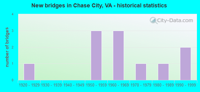
- New bridges - historical statistics
- 11920-1929
- 31950-1959
- 31960-1969
- 11970-1979
- 11980-1989
- 21990-1999


- Bridge Condition - Deck
- 16.7%Good
- 66.7%Satisfactory
- 16.7%Fair

- Bridge Condition - Superstructure
- 33.3%Good
- 50.0%Fair
- 16.7%Poor

- Bridge Condition - Substructure
- 33.3%Satisfactory
- 50.0%Fair
- 16.7%Poor

- Bridge Condition - Channel
- 12.5%Good
- 37.5%Satisfactory
- 25.0%Fair
- 25.0%Poor

- Bridge Condition - Culverts
- 20.0%Good
- 40.0%Satisfactory
- 40.0%Fair
Find on map >> Show street view
Structure Number: 53, Location: 00.05FR17ST/00.15TO14ST (Lat: 38.890694, Lng: -77.103722), Route carried "on" structure: Alternate City street , Year Built: 1981, Status: Open, Structure Length: 6.98m (22.90ft), Average Daily Traffic: 6,600 (year 1987), Truck Traffic: 1%, Average Future Daily Traffic: 18,900 (year 2033), Design Load: HS 20, Features Intersected: CUSTIS MEM. PKWY (I-66), Facility Carried by Structure: NORTH LINCOLIN ST.
Minimum Vertical Clearance: 30+ m (98+ ft), Kilometerpoint: 0.000, Lanes on structure: 2, Lanes under structure: 4, Owner: State Highway Agency, Approaching Roadway Width: 15.8m (51.8ft), Material/Design: Steel, Design/Construction: Stringer/Multi-beam, Number Of Spans In Main Unit: 2, Length of Maximum Span: 40.5m (132.9ft), Curb or Sidewalk Widths: Left: 2.4m (7.9ft), Right: 2.4m (7.9ft), Curb-To-Curb Width: 11.0m (36.1ft), Out-to-Out Width: 16.5m (54.1ft)
Condition: Deck: Satisfactory, Superstructure: Good, Substructure: Satisfactory, Operating Rating: 72.8 metric tons, Method Used To Determine Operating Rating: Load and Resistance Factor (LRFR), Inventory Rating: 56.2 metric tons, Method Used To Determine Inventory Rating: Load and Resistance Factor (LRFR), Structural Evaluation: Equal to present minimum criteria, Deck Geometry: Meets minimum limits, Underclear: Equal to present minimum criteria, Approach Roadway Alignment: Equal to present desirable criteria, Length Of Structure Improvement: 6.98m (22.90ft), Designated Inspection Frequency: Every 24 months, Inspection Date: October 2021, Bridge Improvement Cost: $50,000, Roadway Improvement Cost: $75,000, Total Project Cost: $150,000, Deck Structure Type: Concrete Cast-file-Place, Wearing Surface/Protective System: Wearing Surface: Monolithic Concrete, Deck Protection: Epoxy Coated Reinforcing
Find on map >> Show street view
Structure Number: 5112, Location: .24 FR 76 & .39 TO 686 (Lat: 37.522250, Lng: -77.528278), Route carried "on" structure: State highway 150, Year Built: 1968, Status: Open, Structure Length: 3.89m (12.76ft), Average Daily Traffic: 32,260 (year 2020), Truck Traffic: 2%, Average Future Daily Traffic: 45,165 (year 2040), Design Load: HS 20+Mod, Features Intersected: POWHITE CREEK
Minimum Vertical Clearance: 30+ m (98+ ft), Kilometerpoint: 8.512, Lanes on structure: 4, Base Highway Network: Yes, Owner: State Highway Agency, Approaching Roadway Width: 19.5m (64.0ft), Skew: 4 degrees, Material/Design: Concrete, Design/Construction: Tee Beam, Number Of Spans In Main Unit: 3, Length of Maximum Span: 13.1m (43.0ft), Curb-To-Curb Width: 19.4m (63.6ft), Out-to-Out Width: 20.3m (66.6ft)
Condition: Deck: Satisfactory, Superstructure: Fair, Substructure: Fair, Channel: Satisfactory, Operating Rating: 64.4 metric tons, Method Used To Determine Operating Rating: Load and Resistance Factor (LRFR), Inventory Rating: 49.9 metric tons, Method Used To Determine Inventory Rating: Load and Resistance Factor (LRFR), Structural Evaluation: Somewhat better than minimum adequacy, Deck Geometry: Somewhat better than minimum adequacy, Waterway Adequacy: Better than present minimum criteria, Approach Roadway Alignment: Equal to present desirable criteria, Designated Inspection Frequency: Every 24 months, Inspection Date: October 2021, Deck Structure Type: Concrete Cast-file-Place, Wearing Surface/Protective System: Wearing Surface: Latex Concrete, Deck Protection: Epoxy Coated Reinforcing
Find on map >> Show street view
Structure Number: 5295, Location: 1.29 FR 1921 & .75 TO 667 (Lat: 37.469417, Lng: -77.681406), Route carried "on" structure: County highway 652, Year Built: 1974, Year Reconstructed: 2018, Status: Open, Structure Length: 1.82m (5.97ft), Average Daily Traffic: 5,747 (year 2020), Truck Traffic: 1%, Average Future Daily Traffic: 6,322 (year 2040), Design Load: H 20, Features Intersected: TOMAHAWK CREEK, Facility Carried by Structure: OLD HUNDRED ROAD
Minimum Vertical Clearance: 30+ m (98+ ft), Kilometerpoint: 2.410, Lanes on structure: 2, Owner: State Highway Agency, Approaching Roadway Width: 5.5m (18.0ft), Skew: 4 degrees, Material/Design: Steel, Design/Construction: Culvert, Number Of Spans In Main Unit: 3, Length of Maximum Span: 2.8m (9.2ft)
Condition: Channel: Satisfactory, Culverts: Good, Operating Rating: 44.5 metric tons, Method Used To Determine Operating Rating: Field evaluation and documented engineering judgment, Inventory Rating: 32.7 metric tons, Method Used To Determine Inventory Rating: Field evaluation and documented engineering judgment, Structural Evaluation: Better than present minimum criteria, Waterway Adequacy: Somewhat better than minimum adequacy, Approach Roadway Alignment: Equal to present desirable criteria, Designated Inspection Frequency: Every 24 months, Inspection Date: January 2022
Find on map >> Show street view
Structure Number: 5298, Location: .84 FR 651 & .22 TO 756 (Lat: 37.410658, Lng: -77.591683), Route carried "on" structure: County highway 653, Year Built: 1990, Status: Open, Structure Length: 12.29m (40.32ft), Average Daily Traffic: 5,292 (year 2020), Truck Traffic: 1%, Average Future Daily Traffic: 7,409 (year 2040), Design Load: HS 20+Mod, Features Intersected: ROUTE 288, Facility Carried by Structure: QUALLA ROAD
Minimum Vertical Clearance: 30+ m (98+ ft), Kilometerpoint: 15.102, Lanes on structure: 2, Lanes under structure: 4, Owner: State Highway Agency, Approaching Roadway Width: 9.4m (30.8ft), Skew: 2 degrees, Material/Design: Steel continuous, Design/Construction: Stringer/Multi-beam, Number Of Spans In Main Unit: 3, Number Of Approach Spans: 2, Length of Maximum Span: 34.1m (111.9ft), Curb-To-Curb Width: 9.3m (30.5ft), Out-to-Out Width: 10.3m (33.8ft)
Condition: Deck: Good, Superstructure: Good, Substructure: Satisfactory, Operating Rating: 69.5 metric tons, Method Used To Determine Operating Rating: Load and Resistance Factor (LRFR), Inventory Rating: 53.6 metric tons, Method Used To Determine Inventory Rating: Load and Resistance Factor (LRFR), Structural Evaluation: Equal to present minimum criteria, Deck Geometry: Meets minimum limits, Underclear: Equal to present desirable criteria, Approach Roadway Alignment: Equal to present desirable criteria, Designated Inspection Frequency: Every 24 months, Inspection Date: April 2020, Deck Structure Type: Concrete Cast-file-Place, Wearing Surface/Protective System: Deck Protection: Epoxy Coated Reinforcing
Find on map >> Show street view
Structure Number: 11864, Location: .05 FR 685 &.99 TO 1029 (Lat: 36.776436, Lng: -78.486744), Route carried "on" structure: State highway 49, Year Built: 1957, Status: Open, Structure Length: 0.63m (2.07ft), Average Daily Traffic: 1,579 (year 2020), Truck Traffic: 6%, Average Future Daily Traffic: 1,737 (year 2040), Design Load: HS 20, Features Intersected: LITTLE BLUESTONE CREEK
Minimum Vertical Clearance: 30+ m (98+ ft), Kilometerpoint: 44.693, Lanes on structure: 2, Owner: State Highway Agency, Approaching Roadway Width: 8.5m (27.9ft), Skew: 1 degrees, Material/Design: Concrete, Design/Construction: Culvert, Number Of Spans In Main Unit: 2, Length of Maximum Span: 3.0m (9.8ft)
Condition: Channel: Poor, Culverts: Satisfactory, Operating Rating: 54.4 metric tons, Method Used To Determine Operating Rating: Field evaluation and documented engineering judgment, Inventory Rating: 32.7 metric tons, Method Used To Determine Inventory Rating: Field evaluation and documented engineering judgment, Structural Evaluation: Equal to present minimum criteria, Waterway Adequacy: Somewhat better than minimum adequacy, Approach Roadway Alignment: Equal to present minimum criteria, Length Of Structure Improvement: 0.73m (2.40ft), Designated Inspection Frequency: Every 24 months, Inspection Date: May 2020, Bridge Improvement Cost: $720,000, Roadway Improvement Cost: $360,000, Total Project Cost: $1,100,000 ( Estimate for 2016)
Find on map >> Show street view
Structure Number: 11867, Location: .31 FR 805 & 1.58 TO 685 (Lat: 36.767889, Lng: -78.511217), Route carried "on" structure: State highway 49, Year Built: 1957, Status: Open, Structure Length: 0.82m (2.69ft), Average Daily Traffic: 1,579 (year 2020), Truck Traffic: 6%, Average Future Daily Traffic: 1,737 (year 2040), Design Load: HS 20, Features Intersected: LITTLE BLUESTONE CREEK, Facility Carried by Structure: HWY-FOURTY NINE
Minimum Vertical Clearance: 30+ m (98+ ft), Kilometerpoint: 42.051, Lanes on structure: 2, Owner: State Highway Agency, Approaching Roadway Width: 9.1m (29.9ft), Skew: 1 degrees, Material/Design: Concrete, Design/Construction: Culvert, Number Of Spans In Main Unit: 3, Length of Maximum Span: 2.5m (8.2ft)
Condition: Channel: Poor, Culverts: Fair, Operating Rating: 54.4 metric tons, Method Used To Determine Operating Rating: Field evaluation and documented engineering judgment, Inventory Rating: 32.7 metric tons, Method Used To Determine Inventory Rating: Field evaluation and documented engineering judgment, Structural Evaluation: Somewhat better than minimum adequacy, Waterway Adequacy: Meets minimum limits, Approach Roadway Alignment: Equal to present minimum criteria, Length Of Structure Improvement: 0.91m (2.99ft), Designated Inspection Frequency: Every 24 months, Inspection Date: Febuary 2021, Bridge Improvement Cost: $400,000, Roadway Improvement Cost: $200,000, Total Project Cost: $610,000 ( Estimate for 2017)
Find on map >> Show street view
Structure Number: 11871, Location: .03 FR ENDLY ST &.13TO 47 (Lat: 36.798531, Lng: -78.461392), Route carried "on" structure: State highway 49, Year Built: 1963, Status: Open, Structure Length: 4.94m (16.21ft), Average Daily Traffic: 5,274 (year 2020), Truck Traffic: 6%, Average Future Daily Traffic: 5,801 (year 2040), Design Load: HS 20+Mod, Features Intersected: N&S RAILWAY, Facility Carried by Structure: WEST 2ND STREET
Minimum Vertical Clearance: 30+ m (98+ ft), Kilometerpoint: 48.318, Lanes on structure: 2, Base Highway Network: Yes, Owner: State Highway Agency, Approaching Roadway Width: 12.2m (40.0ft), Material/Design: Steel, Design/Construction: Stringer/Multi-beam, Number Of Spans In Main Unit: 3, Length of Maximum Span: 19.5m (64.0ft), Curb or Sidewalk Widths: Left: 1.5m (4.9ft), Right: 1.5m (4.9ft), Curb-To-Curb Width: 12.2m (40.0ft), Out-to-Out Width: 15.9m (52.2ft)
Condition: Deck: Satisfactory, Superstructure: Fair, Substructure: Fair, Operating Rating: 61.7 metric tons, Method Used To Determine Operating Rating: Load and Resistance Factor (LRFR), Inventory Rating: 47.6 metric tons, Method Used To Determine Inventory Rating: Load and Resistance Factor (LRFR), Structural Evaluation: Somewhat better than minimum adequacy, Deck Geometry: Somewhat better than minimum adequacy, Underclear: Equal to present minimum criteria, Approach Roadway Alignment: Equal to present minimum criteria, Length Of Structure Improvement: 4.94m (16.21ft), Designated Inspection Frequency: Every 24 months, Inspection Date: May 2020, Bridge Improvement Cost: $1,944,000, Roadway Improvement Cost: $972,000, Total Project Cost: $2,930,000, Deck Structure Type: Concrete Cast-file-Place, Wearing Surface/Protective System: Deck Protection: Epoxy Coated Reinforcing
Find on map >> Show street view
Structure Number: 11943, Location: .04 FR 797 & .54 TO 686 (Lat: 36.752508, Lng: -78.437722), Route carried "on" structure: State highway 92, Year Built: 1923, Status: Open, Structure Length: 3.01m (9.88ft), Average Daily Traffic: 810 (year 2020), Truck Traffic: 2%, Average Future Daily Traffic: 891 (year 2040), Design Load: HS 20+Mod, Features Intersected: BUTCHERS CREEK
Minimum Vertical Clearance: 30+ m (98+ ft), Kilometerpoint: 11.006, Lanes on structure: 2, Base Highway Network: Yes, Owner: State Highway Agency, Approaching Roadway Width: 9.1m (29.9ft), Material/Design: Steel, Design/Construction: Stringer/Multi-beam, Number Of Spans In Main Unit: 3, Length of Maximum Span: 10.1m (33.1ft), Curb or Sidewalk Widths: Left: 0.2m (0.7ft), Right: 0.2m (0.7ft), Curb-To-Curb Width: 8.1m (26.6ft), Out-to-Out Width: 9.3m (30.5ft)
Condition: Deck: Satisfactory, Superstructure: Poor, Substructure: Poor, Channel: Fair, Operating Rating: 42.7 metric tons, Method Used To Determine Operating Rating: Load and Resistance Factor (LRFR), Inventory Rating: 32.9 metric tons, Method Used To Determine Inventory Rating: Load and Resistance Factor (LRFR), Structural Evaluation: Meets minimum limits, Deck Geometry: Somewhat better than minimum adequacy, Waterway Adequacy: Somewhat better than minimum adequacy, Approach Roadway Alignment: Equal to present minimum criteria, Length Of Structure Improvement: 3.02m (9.91ft), Designated Inspection Frequency: Every 12 months, Inspection Date: March 2021, Bridge Improvement Cost: $244,000, Roadway Improvement Cost: $50,000, Total Project Cost: $375,000, Deck Structure Type: Concrete Cast-file-Place, Wearing Surface/Protective System: Wearing Surface: Bituminous
Find on map >> Show street view
Structure Number: 11949, Location: .43ECL CHASE 1.8 TO 671 (Lat: 36.787875, Lng: -78.442047), Route carried "on" structure: County highway 600, Year Built: 1956, Status: Open, Structure Length: 0.73m (2.40ft), Average Daily Traffic: 192 (year 2020), Truck Traffic: 3%, Average Future Daily Traffic: 211 (year 2040), Design Load: H 20, Features Intersected: BUTCHERS CREEK, Facility Carried by Structure: CEMETARY ROAD
Minimum Vertical Clearance: 30+ m (98+ ft), Kilometerpoint: 10.282, Lanes on structure: 2, Owner: State Highway Agency, Approaching Roadway Width: 7.0m (23.0ft), Material/Design: Steel, Design/Construction: Culvert, Number Of Spans In Main Unit: 2, Length of Maximum Span: 3.1m (10.2ft)
Condition: Channel: Good, Culverts: Fair, Operating Rating: 44.5 metric tons, Method Used To Determine Operating Rating: Field evaluation and documented engineering judgment, Inventory Rating: 32.7 metric tons, Method Used To Determine Inventory Rating: Field evaluation and documented engineering judgment, Structural Evaluation: Somewhat better than minimum adequacy, Waterway Adequacy: Somewhat better than minimum adequacy, Approach Roadway Alignment: Somewhat better than minimum adequacy, Length Of Structure Improvement: 0.82m (2.69ft), Designated Inspection Frequency: Every 24 months, Inspection Date: June 2020, Bridge Improvement Cost: $72,000, Roadway Improvement Cost: $36,000, Total Project Cost: $120,000 ( Estimate for 2016)
Find on map >> Show street view
Structure Number: 12033, Location: 2.1 FR 688 & 0.8 TO 92 (Lat: 36.749203, Lng: -78.443589), Route carried "on" structure: County highway 686, Year Built: 1962, Status: Posted for load, Structure Length: 0.94m (3.08ft), Average Daily Traffic: 49 (year 2019), Average Future Daily Traffic: 70 (year 2040), Features Intersected: RITTENHOUSE BRANCH, Facility Carried by Structure: ESNON ROAD
Minimum Vertical Clearance: 30+ m (98+ ft), Kilometerpoint: 3.371, Lanes on structure: 2, Owner: State Highway Agency, Approaching Roadway Width: 7.3m (24.0ft), Skew: 1 degrees, Material/Design: Steel, Design/Construction: Stringer/Multi-beam, Number Of Spans In Main Unit: 1, Length of Maximum Span: 9.1m (29.9ft), Curb or Sidewalk Widths: Left: 0.2m (0.7ft), Right: 0.2m (0.7ft), Curb-To-Curb Width: 6.1m (20.0ft), Out-to-Out Width: 6.7m (22.0ft)
Condition: Deck: Fair, Superstructure: Fair, Substructure: Fair, Channel: Fair, Operating Rating: 12.7 metric tons, Method Used To Determine Operating Rating: Field evaluation and documented engineering judgment, Inventory Rating: 7.3 metric tons, Method Used To Determine Inventory Rating: Field evaluation and documented engineering judgment, Structural Evaluation: High priority of corrective action, Deck Geometry: Somewhat better than minimum adequacy, Waterway Adequacy: Somewhat better than minimum adequacy, Approach Roadway Alignment: Equal to present minimum criteria, Bridge Posting: Required (Relationship of Operating Rating to Maximum Legal Load: 0.1 - 9.9% below), Length Of Structure Improvement: 1.16m (3.81ft), Designated Inspection Frequency: Every 12 months, Inspection Date: May 2021, Bridge Improvement Cost: $304,000, Roadway Improvement Cost: $150,000, Total Project Cost: $495,000 ( Estimate for 2017), Deck Structure Type: Wood or Timber, Wearing Surface/Protective System: Wearing Surface: Bituminous
Find on map >> Show street view
Structure Number: 23627, Location: .54 FR 671 0ECL CHASE CTY (Lat: 36.802264, Lng: -78.444106), Route carried "on" structure: State highway 47, Year Built: 1993, Status: Open, Structure Length: 1.07m (3.51ft), Average Daily Traffic: 3,599 (year 2020), Truck Traffic: 8%, Average Future Daily Traffic: 3,959 (year 2040), Design Load: H 20, Features Intersected: BUTCHERS CREEK, Facility Carried by Structure: HWY FOURTY-SEVEN
Minimum Vertical Clearance: 30+ m (98+ ft), Kilometerpoint: 33.612, Lanes on structure: 2, Owner: State Highway Agency, Approaching Roadway Width: 12.5m (41.0ft), Skew: 2 degrees, Material/Design: Concrete, Design/Construction: Culvert, Number Of Spans In Main Unit: 3, Length of Maximum Span: 2.1m (6.9ft)
Condition: Channel: Satisfactory, Culverts: Satisfactory, Operating Rating: 54.4 metric tons, Method Used To Determine Operating Rating: Field evaluation and documented engineering judgment, Inventory Rating: 32.7 metric tons, Method Used To Determine Inventory Rating: Field evaluation and documented engineering judgment, Structural Evaluation: Equal to present minimum criteria, Waterway Adequacy: Equal to present minimum criteria, Approach Roadway Alignment: Equal to present desirable criteria, Length Of Structure Improvement: 3.41m (11.19ft), Designated Inspection Frequency: Every 24 months, Inspection Date: Febuary 2021, Bridge Improvement Cost: $125,000, Roadway Improvement Cost: $125,000, Total Project Cost: $255,000 ( Estimate for 2017)