Bridge Statistics for Cherry Valley, Pennsylvania (PA)
Condition, Traffic, Stress, Structural Evaluation, Project Costs
- National Bridge Inventory (NBI) Statistics
- 15Number of bridges
- 89ft / 26.5mTotal length
- $1,342,000Total costs
- 58,846Total average daily traffic
- 21,440Total average daily truck traffic
- National Bridge Inventory (NBI) Registered Bridges for Cherry Valley
- No street view available for this location
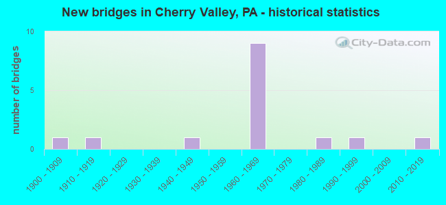
- New bridges - historical statistics
- 11900-1909
- 11910-1919
- 11940-1949
- 91960-1969
- 11980-1989
- 11990-1999
- 12010-2019

- Reconstructed bridges - Historical Statistics
- 11970-1979
- 21980-1989


- Bridge Condition - Deck
- 12.5%Very good
- 50.0%Good
- 12.5%Fair
- 25.0%Poor

- Bridge Condition - Superstructure
- 12.5%Very good
- 50.0%Good
- 12.5%Satisfactory
- 25.0%Fair

- Bridge Condition - Substructure
- 12.5%Very good
- 25.0%Good
- 37.5%Satisfactory
- 25.0%Fair

- Bridge Condition - Channel
- 55.6%Good
- 22.2%Satisfactory
- 22.2%Fair

- Bridge Condition - Culverts
- 33.3%Good
- 33.3%Satisfactory
- 33.3%Poor
Find on map >> Show street view
Structure Number: 782, Location: CHERRY VALLEY BORO (Lat: 41.154956, Lng: -79.798675), Route carried "on" structure: State highway 38, Year Built: 1986, Status: Open, Structure Length: 0.64m (2.10ft), Average Daily Traffic: 2,484 (year 2022), Truck Traffic: 22%, Average Future Daily Traffic: 2,436 (year 2032), Design Load: HS 25 or greater, Features Intersected: SOUTH FORK SCRUBGRASS CR
Minimum Vertical Clearance: 30+ m (98+ ft), Kilometerpoint: 35.779, Lanes on structure: 2, Base Highway Network: Yes, Owner: State Highway Agency, Approaching Roadway Width: 9.8m (32.2ft), Material/Design: Prestressed concrete, Design/Construction: Box Beam or Girders - Multiple, Number Of Spans In Main Unit: 1, Length of Maximum Span: 5.8m (19.0ft), Curb-To-Curb Width: 11.3m (37.1ft), Out-to-Out Width: 12.3m (40.4ft)
Condition: Deck: Good, Superstructure: Good, Substructure: Satisfactory, Channel: Satisfactory, Operating Rating: 89.8 metric tons, Method Used To Determine Operating Rating: Load Factor (LF), Inventory Rating: 66.2 metric tons, Method Used To Determine Inventory Rating: Load Factor (LF), Structural Evaluation: Equal to present minimum criteria, Deck Geometry: Somewhat better than minimum adequacy, Waterway Adequacy: Equal to present minimum criteria, Approach Roadway Alignment: Equal to present desirable criteria, Length Of Structure Improvement: 1.20m (3.94ft), Designated Inspection Frequency: Every 24 months, Inspection Date: January 2021, Deck Structure Type: Other, Wearing Surface/Protective System: Wearing Surface: Bituminous, Membrane: Preformed Fabric
Find on map >> Show street view
Structure Number: 8318, Location: 1.5 MI FROM INT W/SR58 (Lat: 41.159086, Lng: -79.790953), Route carried "on" structure: City street , Year Built: 1912, Status: Posted for load, Structure Length: 0.79m (2.59ft), Average Daily Traffic: 50 (year 2015), Truck Traffic: 9%, Average Future Daily Traffic: 100 (year 2035), Design Load: HS 20, Features Intersected: S FORK LIT SCRUBGRASS CR, Facility Carried by Structure: HEAVEN LANE
Minimum Vertical Clearance: 30+ m (98+ ft), Kilometerpoint: 0.000, Lanes on structure: 1, Owner: County Highway Agency, Approaching Roadway Width: 3.4m (11.2ft), Material/Design: Steel, Design/Construction: Stringer/Multi-beam, Number Of Spans In Main Unit: 1, Length of Maximum Span: 7.6m (24.9ft), Curb-To-Curb Width: 3.9m (12.8ft), Out-to-Out Width: 4.2m (13.8ft)
Condition: Deck: Poor, Superstructure: Fair, Substructure: Fair, Channel: Fair, Operating Rating: 14.5 metric tons, Method Used To Determine Operating Rating: Load Factor (LF), Inventory Rating: 9.1 metric tons, Method Used To Determine Inventory Rating: Load Factor (LF), Structural Evaluation: High priority of replacement, Deck Geometry: Meets minimum limits, Waterway Adequacy: Better than present minimum criteria, Approach Roadway Alignment: Better than present minimum criteria, Bridge Posting: Required (Relationship of Operating Rating to Maximum Legal Load: > 39.9% below), Length Of Structure Improvement: 0.80m (2.62ft), Designated Inspection Frequency: Every 24 months, Other Special Inspection Frequency: Every 12 months, Inspection Date: August 2021, Other Special Inspection Date: August 2021, Bridge Improvement Cost: $19,000, Roadway Improvement Cost: $100,000, Total Project Cost: $251,000, Deck Structure Type: Concrete Cast-file-Place, Wearing Surface/Protective System: Wearing Surface: Bituminous
Find on map >> Show street view
Structure Number: 33715, Location: SCRUBGRASS TOWNSHIP (Lat: 41.184983, Lng: -79.786100), Route carried "on" structure: Interstate 80, Year Built: 1966, Status: Open, Structure Length: 1.22m (4.00ft), Average Daily Traffic: 17,303 (year 2020), Truck Traffic: 39%, Average Future Daily Traffic: 32,504 (year 2032), Design Load: HS 20, Features Intersected: OVER LT SCRUBGRASS CK
Minimum Vertical Clearance: 30+ m (98+ ft), Kilometerpoint: 18.144, Lanes on structure: 4, Base Highway Network: Yes, Owner: State Highway Agency, Approaching Roadway Width: 46.3m (151.9ft), Skew: 21 degrees, Material/Design: Concrete, Design/Construction: Culvert, Number Of Spans In Main Unit: 1, Length of Maximum Span: 12.2m (40.0ft)
Condition: Channel: Good, Culverts: Satisfactory, Operating Rating: 68.9 metric tons, Method Used To Determine Operating Rating: Allowable Stress (AS), Inventory Rating: 40.8 metric tons, Method Used To Determine Inventory Rating: Allowable Stress (AS), Structural Evaluation: Equal to present minimum criteria, Waterway Adequacy: Superior to present desirable criteria, Approach Roadway Alignment: Equal to present desirable criteria, Length Of Structure Improvement: 1.20m (3.94ft), Designated Inspection Frequency: Every 48 months, Inspection Date: September 2019, Bridge Improvement Cost: $66,000, Roadway Improvement Cost: $193,000, Total Project Cost: $885,000
Find on map >> Show street view
Structure Number: 3373, Location: SCRUBGRASS TOWNSHIP (Lat: 41.190706, Lng: -79.783750), Route carried "on" structure: State highway 208, Year Built: 1960, Year Reconstructed: 1992, Status: Open, Structure Length: 1.92m (6.30ft), Average Daily Traffic: 1,067 (year 2020), Truck Traffic: 10%, Average Future Daily Traffic: 2,079 (year 2032), Design Load: HS 20, Features Intersected: OVER LITTLE SCRUBGRASS
Minimum Vertical Clearance: 30+ m (98+ ft), Kilometerpoint: 18.738, Lanes on structure: 2, Owner: State Highway Agency, Approaching Roadway Width: 9.8m (32.2ft), Skew: 1 degrees, Material/Design: Concrete, Design/Construction: Culvert, Number Of Spans In Main Unit: 1, Length of Maximum Span: 19.2m (63.0ft)
Condition: Channel: Fair, Culverts: Poor, Operating Rating: 62.6 metric tons, Method Used To Determine Operating Rating: Allowable Stress (AS), Inventory Rating: 37.2 metric tons, Method Used To Determine Inventory Rating: Allowable Stress (AS), Structural Evaluation: Meets minimum limits, Waterway Adequacy: Superior to present desirable criteria, Approach Roadway Alignment: Equal to present desirable criteria, Length Of Structure Improvement: 2.60m (8.53ft), Designated Inspection Frequency: Every 24 months, Other Special Inspection Frequency: Every 6 months, Inspection Date: April 2021, Other Special Inspection Date: October 2021
Find on map >> Show street view
Structure Number: 33797, Location: SCRUBGRASS TOWNSHIP (Lat: 41.186319, Lng: -79.808247), Route carried "on" structure: State highway , Year Built: 1996, Status: Open, Structure Length: 0.85m (2.79ft), Average Daily Traffic: 245 (year 2021), Truck Traffic: 6%, Average Future Daily Traffic: 261 (year 2032), Design Load: HS 25 or greater, Features Intersected: OVER LT SCRUBGRASS CK, Facility Carried by Structure: SR 3007,SCRUBGRASS
Minimum Vertical Clearance: 30+ m (98+ ft), Kilometerpoint: 1.682, Lanes on structure: 2, Owner: State Highway Agency, Approaching Roadway Width: 7.9m (25.9ft), Material/Design: Concrete, Design/Construction: Culvert, Number Of Spans In Main Unit: 1, Length of Maximum Span: 8.5m (27.9ft)
Condition: Channel: Good, Culverts: Good, Operating Rating: 81.6 metric tons, Method Used To Determine Operating Rating: Load Factor (LF), Inventory Rating: 49.0 metric tons, Method Used To Determine Inventory Rating: Load Factor (LF), Structural Evaluation: Better than present minimum criteria, Waterway Adequacy: Superior to present desirable criteria, Approach Roadway Alignment: Equal to present desirable criteria, Length Of Structure Improvement: 1.50m (4.92ft), Designated Inspection Frequency: Every 48 months, Inspection Date: November 2020
Find on map >> Show street view
Structure Number: 33798, Location: SCRUBGRASS TOWNSHIP (Lat: 41.191722, Lng: -79.801675), Route carried "on" structure: State highway , Year Built: 1965, Status: Open, Structure Length: 9.02m (29.59ft), Average Daily Traffic: 245 (year 2021), Truck Traffic: 6%, Average Future Daily Traffic: 261 (year 2032), Design Load: HS 20, Features Intersected: OVER SR 80,EB/WB, Facility Carried by Structure: SR 3007,ROCKDALE
Minimum Vertical Clearance: 30+ m (98+ ft), Kilometerpoint: 2.356, Lanes on structure: 2, Lanes under structure: 8, Owner: State Highway Agency, Approaching Roadway Width: 7.0m (23.0ft), Skew: 1 degrees, Material/Design: Prestressed concrete, Design/Construction: Box Beam or Girders - Single/Spread, Number Of Spans In Main Unit: 6, Length of Maximum Span: 20.1m (65.9ft), Curb or Sidewalk Widths: Left: 0.5m (1.6ft), Right: 0.5m (1.6ft), Curb-To-Curb Width: 8.5m (27.9ft), Out-to-Out Width: 10.8m (35.4ft)
Condition: Deck: Good, Superstructure: Good, Substructure: Good, Operating Rating: 63.5 metric tons, Method Used To Determine Operating Rating: Load Factor (LF), Inventory Rating: 18.1 metric tons, Method Used To Determine Inventory Rating: Load Factor (LF), Structural Evaluation: Somewhat better than minimum adequacy, Deck Geometry: Equal to present minimum criteria, Underclear: Somewhat better than minimum adequacy, Approach Roadway Alignment: Somewhat better than minimum adequacy, Length Of Structure Improvement: 10.00m (32.81ft), Designated Inspection Frequency: Every 24 months, Inspection Date: October 2021, Deck Structure Type: Concrete Cast-file-Place, Wearing Surface/Protective System: Wearing Surface: Bituminous, Membrane: Preformed Fabric
Find on map >> Show street view
Structure Number: 33808, Location: SCRUBGRASS TOWNSHIP (Lat: 41.183222, Lng: -79.778375), Route carried "on" structure: State highway , Year Built: 1966, Status: Open, Structure Length: 6.74m (22.11ft), Average Daily Traffic: 240 (year 2022), Truck Traffic: 6%, Average Future Daily Traffic: 252 (year 2032), Design Load: HS 20, Features Intersected: OVER SR 80,EB/WB, Facility Carried by Structure: SR 3009,STONE CHRC
Minimum Vertical Clearance: 30+ m (98+ ft), Kilometerpoint: 0.988, Lanes on structure: 2, Lanes under structure: 8, Owner: State Highway Agency, Approaching Roadway Width: 5.5m (18.0ft), Material/Design: Prestressed concrete, Design/Construction: Box Beam or Girders - Multiple, Number Of Spans In Main Unit: 2, Number Of Approach Spans: 2, Length of Maximum Span: 23.8m (78.1ft), Curb or Sidewalk Widths: Left: 0.5m (1.6ft), Right: 0.5m (1.6ft), Curb-To-Curb Width: 8.5m (27.9ft), Out-to-Out Width: 10.3m (33.8ft)
Condition: Deck: Poor, Superstructure: Fair, Substructure: Satisfactory, Operating Rating: 81.6 metric tons, Method Used To Determine Operating Rating: Load Factor (LF), Inventory Rating: 38.1 metric tons, Method Used To Determine Inventory Rating: Load Factor (LF), Structural Evaluation: Somewhat better than minimum adequacy, Deck Geometry: Equal to present minimum criteria, Underclear: Better than present minimum criteria, Approach Roadway Alignment: Better than present minimum criteria, Length Of Structure Improvement: 7.70m (25.26ft), Designated Inspection Frequency: Every 24 months, Inspection Date: April 2020, Deck Structure Type: Concrete Cast-file-Place, Wearing Surface/Protective System: Wearing Surface: Bituminous, Membrane: Preformed Fabric
Find on map >> Show street view
Structure Number: 3381, Location: SCRUBGRASS TOWNSHIP (Lat: 41.176392, Lng: -79.821667), Route carried "on" structure: State highway , Year Built: 1942, Year Reconstructed: 1982, Status: Open, Structure Length: 0.73m (2.40ft), Average Daily Traffic: 125 (year 2021), Truck Traffic: 9%, Average Future Daily Traffic: 186 (year 2032), Design Load: HS 20, Features Intersected: OVER LT SCRUBGRASS CK BR, Facility Carried by Structure: SR 3010
Minimum Vertical Clearance: 30+ m (98+ ft), Kilometerpoint: 4.326, Lanes on structure: 2, Owner: State Highway Agency, Approaching Roadway Width: 6.4m (21.0ft), Material/Design: Concrete, Design/Construction: Slab, Number Of Spans In Main Unit: 1, Length of Maximum Span: 7.0m (23.0ft), Curb-To-Curb Width: 5.2m (17.1ft), Out-to-Out Width: 5.7m (18.7ft)
Condition: Deck: Good, Superstructure: Good, Substructure: Satisfactory, Channel: Good, Operating Rating: 76.2 metric tons, Method Used To Determine Operating Rating: Load Factor (LF), Inventory Rating: 45.4 metric tons, Method Used To Determine Inventory Rating: Load Factor (LF), Structural Evaluation: Equal to present minimum criteria, Deck Geometry: High priority of replacement, Waterway Adequacy: Equal to present desirable criteria, Approach Roadway Alignment: Equal to present desirable criteria, Length Of Structure Improvement: 1.40m (4.59ft), Designated Inspection Frequency: Every 24 months, Inspection Date: June 2020, Bridge Improvement Cost: $1,000, Roadway Improvement Cost: $4,000, Total Project Cost: $17,000, Wearing Surface/Protective System: Wearing Surface: Bituminous
Find on map >> Show street view
Structure Number: 33811, Location: SCRUBGRASS TOWNSHIP (Lat: 41.178514, Lng: -79.784747), Route carried "on" structure: State highway , Year Built: 1962, Status: Open, Structure Length: 1.31m (4.30ft), Average Daily Traffic: 77 (year 2022), Truck Traffic: 9%, Average Future Daily Traffic: 98 (year 2032), Design Load: HS 20+Mod, Features Intersected: OVER LT SCRUBGRASS CREEK, Facility Carried by Structure: SR 3010
Minimum Vertical Clearance: 30+ m (98+ ft), Kilometerpoint: 7.752, Lanes on structure: 2, Owner: State Highway Agency, Approaching Roadway Width: 5.5m (18.0ft), Skew: 2 degrees, Material/Design: Prestressed concrete, Design/Construction: Box Beam or Girders - Single/Spread, Number Of Spans In Main Unit: 1, Length of Maximum Span: 12.5m (41.0ft), Curb or Sidewalk Widths: Left: 0.5m (1.6ft), Right: 0.5m (1.6ft), Curb-To-Curb Width: 9.1m (29.9ft), Out-to-Out Width: 11.0m (36.1ft)
Condition: Deck: Good, Superstructure: Good, Substructure: Good, Channel: Good, Operating Rating: 89.8 metric tons, Method Used To Determine Operating Rating: Load Factor (LF), Inventory Rating: 47.2 metric tons, Method Used To Determine Inventory Rating: Load Factor (LF), Structural Evaluation: Better than present minimum criteria, Deck Geometry: Better than present minimum criteria, Waterway Adequacy: Better than present minimum criteria, Approach Roadway Alignment: Better than present minimum criteria, Length Of Structure Improvement: 2.00m (6.56ft), Designated Inspection Frequency: Every 48 months, Inspection Date: April 2020, Deck Structure Type: Concrete Cast-file-Place, Wearing Surface/Protective System: Wearing Surface: Bituminous
Find on map >> Show street view
Structure Number: 3393, Location: SCRUBGRASS TOWNSHIP (Lat: 41.189094, Lng: -79.786369), Route carried "on" structure: City street 7219, Year Built: 1900, Year Reconstructed: 1989, Status: Posted for load, Structure Length: 1.40m (4.59ft), Average Daily Traffic: 25 (year 2015), Average Future Daily Traffic: 40 (year 2035), Design Load: H 20, Features Intersected: LITTLE SCRUBGRASS CREEK, Facility Carried by Structure: T-462,SMITH ROAD
Minimum Vertical Clearance: 30+ m (98+ ft), Kilometerpoint: 0.000, Lanes on structure: 1, Owner: County Highway Agency, Approaching Roadway Width: 3.4m (11.2ft), Material/Design: Steel, Design/Construction: Stringer/Multi-beam, Number Of Spans In Main Unit: 1, Length of Maximum Span: 13.4m (44.0ft), Curb-To-Curb Width: 4.4m (14.4ft), Out-to-Out Width: 5.0m (16.4ft)
Condition: Deck: Fair, Superstructure: Satisfactory, Substructure: Fair, Channel: Satisfactory, Operating Rating: 35.4 metric tons, Method Used To Determine Operating Rating: Load Factor (LF), Inventory Rating: 20.9 metric tons, Method Used To Determine Inventory Rating: Load Factor (LF), Structural Evaluation: Somewhat better than minimum adequacy, Deck Geometry: Equal to present minimum criteria, Waterway Adequacy: Equal to present desirable criteria, Approach Roadway Alignment: Equal to present desirable criteria, Bridge Posting: Required (Relationship of Operating Rating to Maximum Legal Load: 10.0 - 19.9% below), Length Of Structure Improvement: 1.40m (4.59ft), Designated Inspection Frequency: Every 24 months, Other Special Inspection Frequency: Every 12 months, Inspection Date: June 2020, Other Special Inspection Date: June 2021, Bridge Improvement Cost: $14,000, Roadway Improvement Cost: $127,000, Total Project Cost: $189,000, Deck Structure Type: Open Grating
Find on map >> Show street view
Structure Number: 46145, Location: SEDWICKS MILL (Lat: 41.164833, Lng: -79.785183), Route carried "on" structure: State highway 38, Year Built: 2010, Status: Open, Structure Length: 1.92m (6.30ft), Average Daily Traffic: 2,379 (year 2022), Truck Traffic: 22%, Average Future Daily Traffic: 2,363 (year 2032), Design Load: HL 93, Features Intersected: S FORK LIT SCRUBGRASS
Minimum Vertical Clearance: 30+ m (98+ ft), Kilometerpoint: 36.923, Lanes on structure: 2, Base Highway Network: Yes, Owner: State Highway Agency, Approaching Roadway Width: 12.2m (40.0ft), Skew: 2 degrees, Material/Design: Steel, Design/Construction: Stringer/Multi-beam, Number Of Spans In Main Unit: 1, Length of Maximum Span: 18.9m (62.0ft), Curb or Sidewalk Widths: Left: 0.2m (0.7ft), Right: 0.2m (0.7ft), Curb-To-Curb Width: 11.6m (38.1ft), Out-to-Out Width: 12.6m (41.3ft)
Condition: Deck: Very good, Superstructure: Very good, Substructure: Very good, Channel: Good, Operating Rating: 68.9 metric tons, Method Used To Determine Operating Rating: Load and Resistance Factor (LRFR), Inventory Rating: 53.5 metric tons, Method Used To Determine Inventory Rating: Load and Resistance Factor (LRFR), Structural Evaluation: Equal to present desirable criteria, Deck Geometry: Somewhat better than minimum adequacy, Waterway Adequacy: Equal to present desirable criteria, Approach Roadway Alignment: Equal to present desirable criteria, Designated Inspection Frequency: Every 48 months, Inspection Date: January 2019, Deck Structure Type: Concrete Cast-file-Place, Wearing Surface/Protective System: Wearing Surface: Monolithic Concrete, Deck Protection: Epoxy Coated Reinforcing
Find on map >> Show street view
Structure Number: 33798, Location: SCRUBGRASS TOWNSHIP (Lat: 41.191722, Lng: -79.801675), Route carried "under" structure: Interstate 80, Year Built: 1965, Structure Length: 0. m, Average Daily Traffic: 7,669 (year 2020), Truck Traffic: 40%, Features Intersected: OVER SR 80,EB/WB, Facility Carried by Structure: SR 3007,ROCKDALE
Minimum Vertical Clearance: 5.33m (17.49ft), Kilometerpoint: 16.534, Lanes on structure: 2, Lanes under structure: 4, Material/Design: Prestressed concrete, Design/Construction: Box Beam or Girders - Single/Spread, Length of Maximum Span: 20.1m (65.9ft)
Find on map >> Show street view
Structure Number: 33798, Location: SCRUBGRASS TOWNSHIP (Lat: 41.191722, Lng: -79.801675), Route carried "under" structure: Interstate 80, Year Built: 1965, Structure Length: 0. m, Average Daily Traffic: 9,634 (year 2020), Truck Traffic: 38%, Features Intersected: OVER SR 80,EB/WB, Facility Carried by Structure: SR 3007,ROCKDALE
Minimum Vertical Clearance: 5.31m (17.42ft), Kilometerpoint: 16.531, Lanes on structure: 2, Lanes under structure: 4, Material/Design: Prestressed concrete, Design/Construction: Box Beam or Girders - Single/Spread, Length of Maximum Span: 20.1m (65.9ft)
Find on map >> Show street view
Structure Number: 33808, Location: SCRUBGRASS TOWNSHIP (Lat: 41.183222, Lng: -79.778375), Route carried "under" structure: Interstate 80, Year Built: 1966, Structure Length: 0. m, Average Daily Traffic: 9,634 (year 2020), Truck Traffic: 38%, Features Intersected: OVER SR 80,EB/WB, Facility Carried by Structure: SR 3009,STONE CHRC
Minimum Vertical Clearance: 5.21m (17.09ft), Kilometerpoint: 18.979, Lanes on structure: 2, Lanes under structure: 4, Material/Design: Prestressed concrete, Design/Construction: Box Beam or Girders - Multiple, Length of Maximum Span: 23.8m (78.1ft)
Find on map >> Show street view
Structure Number: 33808, Location: SCRUBGRASS TOWNSHIP (Lat: 41.183222, Lng: -79.778375), Route carried "under" structure: Interstate 80, Year Built: 1966, Structure Length: 0. m, Average Daily Traffic: 7,669 (year 2020), Truck Traffic: 40%, Features Intersected: OVER SR 80,EB/WB, Facility Carried by Structure: SR 3009,STONE CHRC
Minimum Vertical Clearance: 5.19m (17.03ft), Kilometerpoint: 18.963, Lanes on structure: 2, Lanes under structure: 4, Material/Design: Prestressed concrete, Design/Construction: Box Beam or Girders - Multiple, Length of Maximum Span: 23.8m (78.1ft)