Bridge Statistics for Chester, Connecticut (CT)
Condition, Traffic, Stress, Structural Evaluation, Project Costs
- National Bridge Inventory (NBI) Statistics
- 25Number of bridges
- 171ft / 52.5mTotal length
- 317,417Total average daily traffic
- 23,675Total average daily truck traffic
- National Bridge Inventory (NBI) Registered Bridges for Chester
- No street view available for this location
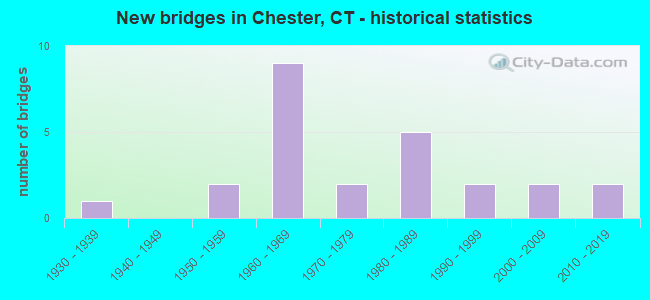
- New bridges - historical statistics
- 11930-1939
- 21950-1959
- 91960-1969
- 21970-1979
- 51980-1989
- 21990-1999
- 22000-2009
- 22010-2019

- Reconstructed bridges - Historical Statistics
- 21980-1989
- 01990-1999
- 12000-2009
- 12010-2019


- Bridge Condition - Deck
- 58.3%Good
- 41.7%Satisfactory

- Bridge Condition - Superstructure
- 7.7%Very good
- 38.5%Good
- 46.2%Satisfactory
- 7.7%Fair

- Bridge Condition - Substructure
- 7.7%Very good
- 69.2%Good
- 23.1%Satisfactory

- Bridge Condition - Channel
- 50.0%Good
- 42.9%Satisfactory
- 7.1%Fair

- Bridge Condition - Culverts
- 75.0%Good
- 12.5%Satisfactory
- 12.5%Fair
Find on map >> Show street view
Structure Number: 128, Location: 1.5 MI N OF ROUTE 113 (Lat: 41.186853, Lng: -73.136819), Route carried "on" structure: Interstate 95, Year Built: 1958, Year Reconstructed: 1989, Status: Open, Structure Length: 2.65m (8.69ft), Average Daily Traffic: 122,400 (year 2017), Truck Traffic: 10%, Average Future Daily Traffic: 181,874 (year 2037), Design Load: HS 20, Features Intersected: ROUTE 130(STRATFORD AVE)
Minimum Vertical Clearance: 30+ m (98+ ft), Kilometerpoint: 52.432, Lanes on structure: 6, Lanes under structure: 2, Base Highway Network: Yes, Owner: State Highway Agency, Approaching Roadway Width: 36.0m (118.1ft), Skew: 33 degrees, Material/Design: Steel, Design/Construction: Stringer/Multi-beam, Number Of Spans In Main Unit: 1, Length of Maximum Span: 24.7m (81.0ft), Curb-To-Curb Width: 35.9m (117.8ft), Out-to-Out Width: 38.9m (127.6ft)
Condition: Deck: Satisfactory, Superstructure: Good, Substructure: Good, Operating Rating: 92.3 metric tons, Method Used To Determine Operating Rating: Load Factor (LF), Inventory Rating: 55.4 metric tons, Method Used To Determine Inventory Rating: Load Factor (LF), Structural Evaluation: Better than present minimum criteria, Deck Geometry: Superior to present desirable criteria, Underclear: Equal to present minimum criteria, Approach Roadway Alignment: Equal to present desirable criteria, Designated Inspection Frequency: Every 24 months, Inspection Date: June 2021, Deck Structure Type: Concrete Cast-file-Place, Wearing Surface/Protective System: Wearing Surface: Bituminous, Membrane: Preformed Fabric, Deck Protection: Epoxy Coated Reinforcing
Find on map >> Show street view
Structure Number: 621, Location: 320 FT S OF ROUTE 148 (Lat: 41.411094, Lng: -72.439864), Route carried "on" structure: State highway 154, Year Built: 2010, Status: Open, Structure Length: 1.28m (4.20ft), Average Daily Traffic: 3,800 (year 2016), Truck Traffic: 3%, Average Future Daily Traffic: 5,646 (year 2036), Design Load: HS 20, Features Intersected: CHESTER CREEK
Minimum Vertical Clearance: 30+ m (98+ ft), Kilometerpoint: 26.184, Lanes on structure: 2, Owner: State Highway Agency, Approaching Roadway Width: 10.4m (34.1ft), Material/Design: Prestressed concrete, Design/Construction: Box Beam or Girders - Multiple, Number Of Spans In Main Unit: 1, Length of Maximum Span: 11.6m (38.1ft), Curb-To-Curb Width: 10.4m (34.1ft), Out-to-Out Width: 11.4m (37.4ft)
Condition: Deck: Satisfactory, Superstructure: Good, Substructure: Good, Channel: Satisfactory, Operating Rating: 68.2 metric tons, Method Used To Determine Operating Rating: Load Factor (LF), Inventory Rating: 33.4 metric tons, Method Used To Determine Inventory Rating: Load Factor (LF), Structural Evaluation: Better than present minimum criteria, Deck Geometry: Somewhat better than minimum adequacy, Waterway Adequacy: Superior to present desirable criteria, Approach Roadway Alignment: Equal to present desirable criteria, Designated Inspection Frequency: Every 24 months, Underwater Inspection Frequency: Every 24 months, Inspection Date: July 2020, Underwater Inspection Date: July 2020, Deck Structure Type: Other, Wearing Surface/Protective System: Wearing Surface: Bituminous, Membrane: Built-up, Deck Protection: Epoxy Coated Reinforcing
Find on map >> Show street view
Structure Number: 1682, Location: EXIT 7 RTE 9 TO RTE 82 (Lat: 41.418950, Lng: -72.493033), Route carried "on" structure: State highway 82, Year Built: 1971, Status: Open, Structure Length: 7.92m (25.98ft), Average Daily Traffic: 1,400 (year 2015), Truck Traffic: 7%, Average Future Daily Traffic: 2,080 (year 2035), Design Load: HS 20, Features Intersected: ROUTE 9
Minimum Vertical Clearance: 30+ m (98+ ft), Kilometerpoint: 0.676, Lanes on structure: 3, Lanes under structure: 5, Base Highway Network: Yes, Owner: State Highway Agency, Approaching Roadway Width: 15.2m (49.9ft), Skew: 22 degrees, Material/Design: Steel continuous, Design/Construction: Stringer/Multi-beam, Number Of Spans In Main Unit: 2, Length of Maximum Span: 38.7m (127.0ft), Curb or Sidewalk Widths: Left: 0.2m (0.7ft), Right: 0.2m (0.7ft), Curb-To-Curb Width: 15.2m (49.9ft), Out-to-Out Width: 19.4m (63.6ft)
Condition: Deck: Good, Superstructure: Satisfactory, Substructure: Good, Operating Rating: 46.3 metric tons, Method Used To Determine Operating Rating: Load Factor (LF), Inventory Rating: 27.8 metric tons, Method Used To Determine Inventory Rating: Load Factor (LF), Structural Evaluation: Equal to present minimum criteria, Deck Geometry: Equal to present minimum criteria, Underclear: Somewhat better than minimum adequacy, Approach Roadway Alignment: Better than present minimum criteria, Designated Inspection Frequency: Every 24 months, Inspection Date: September 2020, Deck Structure Type: Concrete Cast-file-Place, Wearing Surface/Protective System: Wearing Surface: Bituminous, Membrane: Built-up
Find on map >> Show street view
Structure Number: 2937, Location: 55 FT S OF ROUTE 148 (Lat: 41.402939, Lng: -72.450867), Route carried "on" structure: City street , Year Built: 2016, Status: Open, Structure Length: 0.94m (3.08ft), Average Daily Traffic: 2,080 (year 2020), Truck Traffic: 2%, Average Future Daily Traffic: 3,091 (year 2040), Design Load: HL 93, Features Intersected: PATTACONK BROOK, Facility Carried by Structure: MAIN STREET
Minimum Vertical Clearance: 30+ m (98+ ft), Kilometerpoint: 0.016, Lanes on structure: 2, Owner: State Highway Agency, Approaching Roadway Width: 13.7m (44.9ft), Material/Design: Steel, Design/Construction: Stringer/Multi-beam, Number Of Spans In Main Unit: 1, Length of Maximum Span: 8.5m (27.9ft), Curb or Sidewalk Widths: Left: 4.5m (14.8ft), Right: 4.5m (14.8ft), Curb-To-Curb Width: 11.2m (36.7ft), Out-to-Out Width: 20.2m (66.3ft)
Condition: Deck: Good, Superstructure: Good, Substructure: Good, Channel: Good, Operating Rating: 49.6 metric tons, Method Used To Determine Operating Rating: Load and Resistance Factor Rating (LRFR) rating reported by rating factor(RF) method using HL-93 loadings, Inventory Rating: 38.2 metric tons, Method Used To Determine Inventory Rating: Load and Resistance Factor Rating (LRFR) rating reported by rating factor(RF) method using HL-93 loadings, Structural Evaluation: Better than present minimum criteria, Deck Geometry: Somewhat better than minimum adequacy, Waterway Adequacy: Superior to present desirable criteria, Approach Roadway Alignment: Meets minimum limits, Designated Inspection Frequency: Every 24 months, Inspection Date: May 2020, Deck Structure Type: Concrete Cast-file-Place, Wearing Surface/Protective System: Wearing Surface: Bituminous, Membrane: Other, Deck Protection: Epoxy Coated Reinforcing
Find on map >> Show street view
Structure Number: 3439, Location: 0.46 MI N OF MAIN ST UP (Lat: 41.406203, Lng: -72.475578), Route carried "on" structure: City street , Year Built: 1968, Status: Open, Structure Length: 7.77m (25.49ft), Average Daily Traffic: 387 (year 2020), Truck Traffic: 7%, Average Future Daily Traffic: 575 (year 2040), Design Load: HS 20, Features Intersected: ROUTE 9, Facility Carried by Structure: WIG HILL ROAD
Minimum Vertical Clearance: 30+ m (98+ ft), Kilometerpoint: 37.079, Lanes on structure: 2, Lanes under structure: 6, Owner: State Highway Agency, Approaching Roadway Width: 9.1m (29.9ft), Skew: 1 degrees, Material/Design: Steel continuous, Design/Construction: Stringer/Multi-beam, Number Of Spans In Main Unit: 2, Length of Maximum Span: 38.1m (125.0ft), Curb or Sidewalk Widths: Left: 0.5m (1.6ft), Right: 0.5m (1.6ft), Curb-To-Curb Width: 9.1m (29.9ft), Out-to-Out Width: 10.8m (35.4ft)
Condition: Deck: Satisfactory, Superstructure: Satisfactory, Substructure: Good, Operating Rating: 33.7 metric tons, Method Used To Determine Operating Rating: Load and Resistance Factor Rating (LRFR) rating reported by rating factor(RF) method using HL-93 loadings, Inventory Rating: 25.9 metric tons, Method Used To Determine Inventory Rating: Load and Resistance Factor Rating (LRFR) rating reported by rating factor(RF) method using HL-93 loadings, Structural Evaluation: Equal to present minimum criteria, Deck Geometry: Equal to present minimum criteria, Underclear: Equal to present minimum criteria, Approach Roadway Alignment: Better than present minimum criteria, Designated Inspection Frequency: Every 24 months, Inspection Date: October 2020, Deck Structure Type: Concrete Cast-file-Place, Wearing Surface/Protective System: Wearing Surface: Bituminous, Membrane: Built-up
Find on map >> Show street view
Structure Number: 344, Location: 0.6 MI N OF ROUTE 82 (Lat: 41.424411, Lng: -72.502497), Route carried "on" structure: State highway 9, Year Built: 1967, Status: Open, Structure Length: 4.02m (13.19ft), Average Daily Traffic: 14,200 (year 2015), Truck Traffic: 6%, Average Future Daily Traffic: 21,100 (year 2035), Design Load: HS 20, Features Intersected: TURKEY HILL ROAD
Minimum Vertical Clearance: 30+ m (98+ ft), Kilometerpoint: 18.202, Lanes on structure: 2, Lanes under structure: 2, Base Highway Network: Yes, Owner: State Highway Agency, Approaching Roadway Width: 11.6m (38.1ft), Skew: 3 degrees, Material/Design: Prestressed concrete, Design/Construction: Stringer/Multi-beam, Number Of Spans In Main Unit: 3, Length of Maximum Span: 18.6m (61.0ft), Curb or Sidewalk Widths: Left: 0.5m (1.6ft), Right: 0.5m (1.6ft), Curb-To-Curb Width: 11.6m (38.1ft), Out-to-Out Width: 13.3m (43.6ft)
Condition: Deck: Good, Superstructure: Satisfactory, Substructure: Good, Operating Rating: 57.3 metric tons, Method Used To Determine Operating Rating: Load and Resistance Factor Rating (LRFR) rating reported by rating factor(RF) method using HL-93 loadings, Inventory Rating: 40.2 metric tons, Method Used To Determine Inventory Rating: Load and Resistance Factor Rating (LRFR) rating reported by rating factor(RF) method using HL-93 loadings, Structural Evaluation: Equal to present minimum criteria, Deck Geometry: Better than present minimum criteria, Underclear: Somewhat better than minimum adequacy, Approach Roadway Alignment: Equal to present desirable criteria, Designated Inspection Frequency: Every 24 months, Inspection Date: June 2020, Deck Structure Type: Concrete Cast-file-Place, Wearing Surface/Protective System: Wearing Surface: Bituminous, Membrane: Built-up
Find on map >> Show street view
Structure Number: 3441, Location: 0.6 MI N OF ROUTE 82 (Lat: 41.424933, Lng: -72.502450), Route carried "on" structure: State highway 9, Year Built: 1967, Status: Open, Structure Length: 4.33m (14.21ft), Average Daily Traffic: 14,200 (year 2015), Truck Traffic: 6%, Average Future Daily Traffic: 21,100 (year 2035), Design Load: HS 20, Features Intersected: TURKEY HILL ROAD
Minimum Vertical Clearance: 30+ m (98+ ft), Kilometerpoint: 18.218, Lanes on structure: 2, Lanes under structure: 2, Base Highway Network: Yes, Owner: State Highway Agency, Approaching Roadway Width: 12.8m (42.0ft), Skew: 3 degrees, Material/Design: Prestressed concrete, Design/Construction: Stringer/Multi-beam, Number Of Spans In Main Unit: 3, Length of Maximum Span: 18.6m (61.0ft), Curb or Sidewalk Widths: Left: 0.5m (1.6ft), Right: 0.5m (1.6ft), Curb-To-Curb Width: 12.8m (42.0ft), Out-to-Out Width: 14.5m (47.6ft)
Condition: Deck: Satisfactory, Superstructure: Fair, Substructure: Good, Operating Rating: 59.0 metric tons, Method Used To Determine Operating Rating: Load and Resistance Factor Rating (LRFR) rating reported by rating factor(RF) method using HL-93 loadings, Inventory Rating: 44.1 metric tons, Method Used To Determine Inventory Rating: Load and Resistance Factor Rating (LRFR) rating reported by rating factor(RF) method using HL-93 loadings, Structural Evaluation: Somewhat better than minimum adequacy, Deck Geometry: Equal to present desirable criteria, Underclear: Equal to present minimum criteria, Approach Roadway Alignment: Equal to present desirable criteria, Designated Inspection Frequency: Every 24 months, Inspection Date: June 2020, Deck Structure Type: Concrete Cast-file-Place, Wearing Surface/Protective System: Wearing Surface: Bituminous, Membrane: Built-up
Find on map >> Show street view
Structure Number: 3453, Location: ROUTE 9 EXIT NO. 6 (Lat: 41.399883, Lng: -72.472597), Route carried "on" structure: State highway 9, Year Built: 1967, Status: Open, Structure Length: 4.75m (15.58ft), Average Daily Traffic: 13,600 (year 2015), Truck Traffic: 6%, Average Future Daily Traffic: 20,208 (year 2035), Design Load: HS 20, Features Intersected: ROUTE 148 (WEST MAIN ST)
Minimum Vertical Clearance: 30+ m (98+ ft), Kilometerpoint: 14.339, Lanes on structure: 2, Lanes under structure: 2, Base Highway Network: Yes, Owner: State Highway Agency, Approaching Roadway Width: 12.8m (42.0ft), Skew: 12 degrees, Material/Design: Prestressed concrete, Design/Construction: Stringer/Multi-beam, Number Of Spans In Main Unit: 3, Length of Maximum Span: 24.4m (80.1ft), Curb or Sidewalk Widths: Left: 0.5m (1.6ft), Right: 0.5m (1.6ft), Curb-To-Curb Width: 12.8m (42.0ft), Out-to-Out Width: 14.5m (47.6ft)
Condition: Deck: Good, Superstructure: Satisfactory, Substructure: Satisfactory, Operating Rating: 51.2 metric tons, Method Used To Determine Operating Rating: Load and Resistance Factor Rating (LRFR) rating reported by rating factor(RF) method using HL-93 loadings, Inventory Rating: 38.6 metric tons, Method Used To Determine Inventory Rating: Load and Resistance Factor Rating (LRFR) rating reported by rating factor(RF) method using HL-93 loadings, Structural Evaluation: Equal to present minimum criteria, Deck Geometry: Equal to present desirable criteria, Underclear: Superior to present desirable criteria, Approach Roadway Alignment: Equal to present desirable criteria, Designated Inspection Frequency: Every 24 months, Inspection Date: August 2020, Deck Structure Type: Concrete Cast-file-Place, Wearing Surface/Protective System: Wearing Surface: Bituminous, Membrane: Built-up
Find on map >> Show street view
Structure Number: 3454, Location: ROUTE 9 EXIT NO. 6 (Lat: 41.399739, Lng: -72.473297), Route carried "on" structure: State highway 9, Year Built: 1967, Status: Open, Structure Length: 4.79m (15.72ft), Average Daily Traffic: 13,600 (year 2015), Truck Traffic: 6%, Average Future Daily Traffic: 20,208 (year 2035), Design Load: HS 20, Features Intersected: ROUTE 148 (WEST MAIN ST)
Minimum Vertical Clearance: 30+ m (98+ ft), Kilometerpoint: 14.355, Lanes on structure: 2, Lanes under structure: 2, Base Highway Network: Yes, Owner: State Highway Agency, Approaching Roadway Width: 11.6m (38.1ft), Skew: 10 degrees, Material/Design: Prestressed concrete, Design/Construction: Stringer/Multi-beam, Number Of Spans In Main Unit: 3, Length of Maximum Span: 21.9m (71.9ft), Curb or Sidewalk Widths: Left: 0.5m (1.6ft), Right: 0.5m (1.6ft), Curb-To-Curb Width: 11.6m (38.1ft), Out-to-Out Width: 13.3m (43.6ft)
Condition: Deck: Good, Superstructure: Satisfactory, Substructure: Satisfactory, Operating Rating: 58.3 metric tons, Method Used To Determine Operating Rating: Load and Resistance Factor Rating (LRFR) rating reported by rating factor(RF) method using HL-93 loadings, Inventory Rating: 44.1 metric tons, Method Used To Determine Inventory Rating: Load and Resistance Factor Rating (LRFR) rating reported by rating factor(RF) method using HL-93 loadings, Structural Evaluation: Equal to present minimum criteria, Deck Geometry: Equal to present minimum criteria, Underclear: Superior to present desirable criteria, Approach Roadway Alignment: Equal to present desirable criteria, Designated Inspection Frequency: Every 24 months, Inspection Date: August 2020, Deck Structure Type: Concrete Cast-file-Place, Wearing Surface/Protective System: Wearing Surface: Bituminous, Membrane: Built-up
Find on map >> Show street view
Structure Number: 4605, Location: 0.3 MI N OF ROUTE 148 (Lat: 41.407078, Lng: -72.454108), Route carried "on" structure: City street , Year Built: 2001, Status: Open, Structure Length: 0.85m (2.79ft), Average Daily Traffic: 800 (year 2019), Truck Traffic: 7%, Average Future Daily Traffic: 1,189 (year 2039), Design Load: HS 20, Features Intersected: GREAT BROOK, Facility Carried by Structure: NORTH MAIN STREET
Minimum Vertical Clearance: 30+ m (98+ ft), Kilometerpoint: 0.531, Lanes on structure: 2, Owner: Town or Township Highway Agency, Approaching Roadway Width: 6.7m (22.0ft), Material/Design: Concrete, Design/Construction: Culvert, Number Of Spans In Main Unit: 2, Length of Maximum Span: 4.0m (13.1ft), Curb or Sidewalk Widths: Left: 1.5m (4.9ft), Right: 0.0m, Curb-To-Curb Width: 8.1m (26.6ft), Out-to-Out Width: 10.6m (34.8ft)
Condition: Channel: Satisfactory, Culverts: Good, Operating Rating: 42.6 metric tons, Method Used To Determine Operating Rating: Field evaluation and documented engineering judgment, Inventory Rating: 32.7 metric tons, Method Used To Determine Inventory Rating: Field evaluation and documented engineering judgment, Structural Evaluation: Better than present minimum criteria, Deck Geometry: Somewhat better than minimum adequacy, Waterway Adequacy: Better than present minimum criteria, Approach Roadway Alignment: Equal to present minimum criteria, Designated Inspection Frequency: Every 24 months, Inspection Date: Febuary 2022, Deck Structure Type: Other, Wearing Surface/Protective System: Wearing Surface: Bituminous, Membrane: Built-up, Deck Protection: Epoxy Coated Reinforcing
Find on map >> Show street view
Structure Number: 4608, Location: 90 FT N OF ROUTE 148 (Lat: 41.401014, Lng: -72.488794), Route carried "on" structure: City street , Year Built: 1950, Year Reconstructed: 2008, Status: Open, Structure Length: 0.98m (3.22ft), Average Daily Traffic: 150 (year 2019), Truck Traffic: 10%, Average Future Daily Traffic: 223 (year 2039), Design Load: HS 20, Features Intersected: PATTACONK BROOK, Facility Carried by Structure: WIG HILL ROAD
Minimum Vertical Clearance: 30+ m (98+ ft), Kilometerpoint: 0.016, Lanes on structure: 1, Owner: Town or Township Highway Agency, Approaching Roadway Width: 4.7m (15.4ft), Material/Design: Wood or Timber, Design/Construction: Slab, Number Of Spans In Main Unit: 2, Length of Maximum Span: 9.4m (30.8ft), Curb-To-Curb Width: 4.7m (15.4ft), Out-to-Out Width: 5.3m (17.4ft)
Condition: Deck: Good, Superstructure: Good, Substructure: Satisfactory, Channel: Good, Operating Rating: 50.3 metric tons, Method Used To Determine Operating Rating: Allowable Stress (AS), Inventory Rating: 35.6 metric tons, Method Used To Determine Inventory Rating: Allowable Stress (AS), Structural Evaluation: Equal to present minimum criteria, Deck Geometry: High priority of replacement, Waterway Adequacy: Equal to present minimum criteria, Approach Roadway Alignment: Somewhat better than minimum adequacy, Designated Inspection Frequency: Every 24 months, Inspection Date: Febuary 2022, Deck Structure Type: Wood or Timber, Wearing Surface/Protective System: Wearing Surface: Wood or Timber, Deck Protection: Other
Find on map >> Show street view
Structure Number: 5284, Location: 0.3 MI E OF ROUTE 9 (Lat: 41.398425, Lng: -72.465475), Route carried "on" structure: State highway 148, Year Built: 1984, Status: Open, Structure Length: 0.79m (2.59ft), Average Daily Traffic: 4,000 (year 2016), Truck Traffic: 2%, Average Future Daily Traffic: 5,944 (year 2036), Features Intersected: PATTACONK BROOK
Minimum Vertical Clearance: 30+ m (98+ ft), Kilometerpoint: 19.908, Lanes on structure: 2, Owner: State Highway Agency, Approaching Roadway Width: 8.2m (26.9ft), Material/Design: Concrete, Design/Construction: Culvert, Number Of Spans In Main Unit: 2, Length of Maximum Span: 3.7m (12.1ft), Curb-To-Curb Width: 8.3m (27.2ft), Out-to-Out Width: 12.2m (40.0ft)
Condition: Channel: Good, Culverts: Fair, Operating Rating: 42.6 metric tons, Method Used To Determine Operating Rating: Field evaluation and documented engineering judgment, Inventory Rating: 32.7 metric tons, Method Used To Determine Inventory Rating: Field evaluation and documented engineering judgment, Structural Evaluation: Somewhat better than minimum adequacy, Deck Geometry: High priority of corrective action, Waterway Adequacy: Equal to present minimum criteria, Approach Roadway Alignment: Equal to present desirable criteria, Designated Inspection Frequency: Every 24 months, Inspection Date: August 2021, Deck Structure Type: Other, Wearing Surface/Protective System: Wearing Surface: Bituminous, Membrane: Built-up
Find on map >> Show street view
Structure Number: 5285, Location: 0.6 MI E OF ROUTE 9 (Lat: 41.399342, Lng: -72.462528), Route carried "on" structure: State highway 148, Year Built: 1984, Status: Open, Structure Length: 1.37m (4.49ft), Average Daily Traffic: 4,000 (year 2016), Truck Traffic: 2%, Average Future Daily Traffic: 5,944 (year 2036), Design Load: HS 20, Features Intersected: PATTACONK BROOK
Minimum Vertical Clearance: 30+ m (98+ ft), Kilometerpoint: 20.197, Lanes on structure: 2, Owner: State Highway Agency, Approaching Roadway Width: 8.5m (27.9ft), Skew: 4 degrees, Material/Design: Concrete, Design/Construction: Culvert, Number Of Spans In Main Unit: 3, Length of Maximum Span: 4.3m (14.1ft), Curb-To-Curb Width: 8.5m (27.9ft), Out-to-Out Width: 16.8m (55.1ft)
Condition: Channel: Satisfactory, Culverts: Satisfactory, Operating Rating: 42.6 metric tons, Method Used To Determine Operating Rating: Field evaluation and documented engineering judgment, Inventory Rating: 32.7 metric tons, Method Used To Determine Inventory Rating: Field evaluation and documented engineering judgment, Structural Evaluation: Equal to present minimum criteria, Deck Geometry: Meets minimum limits, Waterway Adequacy: Equal to present minimum criteria, Approach Roadway Alignment: Equal to present desirable criteria, Designated Inspection Frequency: Every 24 months, Inspection Date: August 2021
Find on map >> Show street view
Structure Number: 5286, Location: 0.3 MI N OF ROUTE 148 (Lat: 41.406686, Lng: -72.453719), Route carried "on" structure: City street , Year Built: 1983, Status: Open, Structure Length: 0.79m (2.59ft), Average Daily Traffic: 800 (year 2019), Truck Traffic: 7%, Average Future Daily Traffic: 1,189 (year 2039), Design Load: HS 20, Features Intersected: GREAT BROOK, Facility Carried by Structure: NORTH MAIN STREET
Minimum Vertical Clearance: 30+ m (98+ ft), Kilometerpoint: 0.451, Lanes on structure: 2, Owner: Town or Township Highway Agency, Approaching Roadway Width: 6.7m (22.0ft), Skew: 3 degrees, Material/Design: Concrete, Design/Construction: Culvert, Number Of Spans In Main Unit: 2, Length of Maximum Span: 3.7m (12.1ft), Curb or Sidewalk Widths: Left: 1.2m (3.9ft), Right: 0.9m (3.0ft), Curb-To-Curb Width: 6.7m (22.0ft), Out-to-Out Width: 10.7m (35.1ft)
Condition: Channel: Satisfactory, Culverts: Good, Operating Rating: 42.6 metric tons, Method Used To Determine Operating Rating: Field evaluation and documented engineering judgment, Inventory Rating: 32.7 metric tons, Method Used To Determine Inventory Rating: Field evaluation and documented engineering judgment, Structural Evaluation: Better than present minimum criteria, Deck Geometry: Meets minimum limits, Waterway Adequacy: Better than present minimum criteria, Approach Roadway Alignment: Equal to present minimum criteria, Designated Inspection Frequency: Every 24 months, Inspection Date: Febuary 2022, Wearing Surface/Protective System: Wearing Surface: Bituminous
Find on map >> Show street view
Structure Number: 5459, Location: 0.5 MI W OF ROUTE 9 (Lat: 41.398636, Lng: -72.480236), Route carried "on" structure: State highway 148, Year Built: 1939, Year Reconstructed: 1986, Status: Open, Structure Length: 0.82m (2.69ft), Average Daily Traffic: 4,800 (year 2016), Truck Traffic: 2%, Average Future Daily Traffic: 7,132 (year 2036), Design Load: HS 20, Features Intersected: PATTACONK BROOK
Minimum Vertical Clearance: 30+ m (98+ ft), Kilometerpoint: 18.556, Lanes on structure: 2, Owner: State Highway Agency, Approaching Roadway Width: 10.1m (33.1ft), Skew: 3 degrees, Material/Design: Prestressed concrete, Design/Construction: Slab, Number Of Spans In Main Unit: 1, Length of Maximum Span: 7.3m (24.0ft), Curb-To-Curb Width: 10.1m (33.1ft), Out-to-Out Width: 10.8m (35.4ft)
Condition: Deck: Good, Superstructure: Good, Substructure: Good, Channel: Satisfactory, Operating Rating: 80.7 metric tons, Method Used To Determine Operating Rating: Load Factor (LF), Inventory Rating: 48.3 metric tons, Method Used To Determine Inventory Rating: Load Factor (LF), Structural Evaluation: Better than present minimum criteria, Deck Geometry: Meets minimum limits, Waterway Adequacy: Equal to present minimum criteria, Approach Roadway Alignment: Equal to present desirable criteria, Designated Inspection Frequency: Every 24 months, Inspection Date: Febuary 2021, Deck Structure Type: Other, Wearing Surface/Protective System: Wearing Surface: Bituminous, Membrane: Built-up
Find on map >> Show street view
Structure Number: 5603, Location: 700 FEET NORTH OF SR 529 (Lat: 41.733992, Lng: -72.713497), Route carried "on" structure: City street , Year Built: 1987, Status: Open, Structure Length: 4.07m (13.35ft), Average Daily Traffic: 11,600 (year 2018), Truck Traffic: 10%, Average Future Daily Traffic: 17,236 (year 2038), Design Load: HS 20, Features Intersected: SO. BRANCH OF PARK RIVER, Facility Carried by Structure: NEWFIELD AVENUE
Minimum Vertical Clearance: 30+ m (98+ ft), Kilometerpoint: 0.000, Lanes on structure: 3, Owner: City or Municipal Highway Agency, Approaching Roadway Width: 11.3m (37.1ft), Material/Design: Prestressed concrete continuous, Design/Construction: Box Beam or Girders - Multiple, Number Of Spans In Main Unit: 2, Length of Maximum Span: 20.1m (65.9ft), Curb or Sidewalk Widths: Left: 3.2m (10.5ft), Right: 3.0m (9.8ft), Curb-To-Curb Width: 11.3m (37.1ft), Out-to-Out Width: 18.3m (60.0ft)
Condition: Deck: Satisfactory, Superstructure: Satisfactory, Substructure: Good, Channel: Good, Operating Rating: 34.3 metric tons, Method Used To Determine Operating Rating: Load and Resistance Factor Rating (LRFR) rating reported by rating factor(RF) method using HL-93 loadings, Inventory Rating: 26.2 metric tons, Method Used To Determine Inventory Rating: Load and Resistance Factor Rating (LRFR) rating reported by rating factor(RF) method using HL-93 loadings, Structural Evaluation: Equal to present minimum criteria, Deck Geometry: High priority of replacement, Waterway Adequacy: Equal to present desirable criteria, Approach Roadway Alignment: Equal to present desirable criteria, Designated Inspection Frequency: Every 24 months, Inspection Date: June 2021, Deck Structure Type: Other, Wearing Surface/Protective System: Wearing Surface: Bituminous, Membrane: Preformed Fabric, Deck Protection: Epoxy Coated Reinforcing
Find on map >> Show street view
Structure Number: 6038, Location: 0.2 MI W OF ROUTE 9 (Lat: 41.399067, Lng: -72.475800), Route carried "on" structure: State highway 148, Year Built: 1991, Status: Open, Structure Length: 0.76m (2.49ft), Average Daily Traffic: 4,800 (year 2016), Truck Traffic: 2%, Average Future Daily Traffic: 7,132 (year 2036), Features Intersected: PATTACONK BROOK
Minimum Vertical Clearance: 30+ m (98+ ft), Kilometerpoint: 18.942, Lanes on structure: 2, Owner: State Highway Agency, Approaching Roadway Width: 7.0m (23.0ft), Material/Design: Concrete, Design/Construction: Culvert, Number Of Spans In Main Unit: 2, Length of Maximum Span: 3.7m (12.1ft), Curb-To-Curb Width: 9.1m (29.9ft), Out-to-Out Width: 10.4m (34.1ft)
Condition: Channel: Good, Culverts: Good, Operating Rating: 42.6 metric tons, Method Used To Determine Operating Rating: Field evaluation and documented engineering judgment, Inventory Rating: 32.7 metric tons, Method Used To Determine Inventory Rating: Field evaluation and documented engineering judgment, Structural Evaluation: Better than present minimum criteria, Deck Geometry: Meets minimum limits, Waterway Adequacy: Equal to present minimum criteria, Approach Roadway Alignment: Equal to present desirable criteria, Designated Inspection Frequency: Every 48 months, Inspection Date: June 2021, Deck Structure Type: Other, Wearing Surface/Protective System: Wearing Surface: Bituminous, Membrane: Built-up, Deck Protection: Epoxy Coated Reinforcing
Find on map >> Show street view
Structure Number: 6061, Location: 540 FT N OF ROUTE 148 (Lat: 41.404972, Lng: -72.451481), Route carried "on" structure: City street , Year Built: 1990, Status: Open, Structure Length: 0.91m (2.99ft), Average Daily Traffic: 800 (year 2019), Truck Traffic: 7%, Average Future Daily Traffic: 1,189 (year 2039), Design Load: HS 20, Features Intersected: GREAT BROOK, Facility Carried by Structure: NORTH MAIN STREET
Minimum Vertical Clearance: 30+ m (98+ ft), Kilometerpoint: 0.161, Lanes on structure: 2, Owner: Town or Township Highway Agency, Approaching Roadway Width: 7.3m (24.0ft), Skew: 1 degrees, Material/Design: Concrete, Design/Construction: Culvert, Number Of Spans In Main Unit: 2, Length of Maximum Span: 4.3m (14.1ft), Curb or Sidewalk Widths: Left: 1.5m (4.9ft), Right: 0.0m, Curb-To-Curb Width: 7.4m (24.3ft), Out-to-Out Width: 9.8m (32.2ft)
Condition: Channel: Fair, Culverts: Good, Operating Rating: 42.6 metric tons, Method Used To Determine Operating Rating: Field evaluation and documented engineering judgment, Inventory Rating: 32.7 metric tons, Method Used To Determine Inventory Rating: Field evaluation and documented engineering judgment, Structural Evaluation: Better than present minimum criteria, Deck Geometry: Meets minimum limits, Waterway Adequacy: Better than present minimum criteria, Approach Roadway Alignment: Equal to present desirable criteria, Designated Inspection Frequency: Every 24 months, Inspection Date: January 2022, Deck Structure Type: Other, Wearing Surface/Protective System: Wearing Surface: Bituminous, Membrane: Built-up, Deck Protection: Epoxy Coated Reinforcing
Find on map >> Show street view
Structure Number: 6637, Location: 0.7 MI W OF ROUTE 15 (Lat: 41.399475, Lng: -72.485089), Route carried "on" structure: State highway 148, Year Built: 1984, Status: Open, Structure Length: 0.85m (2.79ft), Average Daily Traffic: 4,400 (year 2015), Truck Traffic: 5%, Average Future Daily Traffic: 6,538 (year 2035), Design Load: HS 20, Features Intersected: PATTACONK BROOK
Minimum Vertical Clearance: 30+ m (98+ ft), Kilometerpoint: 18.137, Lanes on structure: 2, Owner: State Highway Agency, Approaching Roadway Width: 8.7m (28.5ft), Skew: 4 degrees, Material/Design: Steel, Design/Construction: Culvert, Number Of Spans In Main Unit: 2, Length of Maximum Span: 3.4m (11.2ft)
Condition: Channel: Good, Culverts: Good, Operating Rating: 82.0 metric tons, Method Used To Determine Operating Rating: Load and Resistance Factor Rating (LRFR) rating reported by rating factor(RF) method using HL-93 loadings, Inventory Rating: 63.2 metric tons, Method Used To Determine Inventory Rating: Load and Resistance Factor Rating (LRFR) rating reported by rating factor(RF) method using HL-93 loadings, Structural Evaluation: Better than present minimum criteria, Waterway Adequacy: Equal to present minimum criteria, Approach Roadway Alignment: Equal to present desirable criteria, Designated Inspection Frequency: Every 48 months, Inspection Date: March 2019
Find on map >> Show street view
Structure Number: 6639, Location: 0.4 MI N OF ROUTE 82 (Lat: 41.422747, Lng: -72.498878), Route carried "on" structure: State highway 9, Year Built: 1967, Year Reconstructed: 2016, Status: Open, Structure Length: 1.16m (3.81ft), Average Daily Traffic: 27,500 (year 2015), Truck Traffic: 6%, Average Future Daily Traffic: 40,862 (year 2035), Design Load: HS 20, Features Intersected: GREAT BROOK
Minimum Vertical Clearance: 30+ m (98+ ft), Kilometerpoint: 17.815, Lanes on structure: 6, Base Highway Network: Yes, Owner: State Highway Agency, Approaching Roadway Width: 25.0m (82.0ft), Skew: 24 degrees, Material/Design: Steel, Design/Construction: Culvert, Number Of Spans In Main Unit: 3, Length of Maximum Span: 1.8m (5.9ft)
Condition: Channel: Good, Culverts: Good, Structural Evaluation: Better than present minimum criteria, Waterway Adequacy: Superior to present desirable criteria, Approach Roadway Alignment: Equal to present desirable criteria, Designated Inspection Frequency: Every 48 months, Inspection Date: September 2018
Find on map >> Show street view
Structure Number: 7025, Location: 0.2 MI E OF PLEASANT ST. (Lat: 41.408333, Lng: -72.459722), Route carried "on" structure: City street , Year Built: 2009, Status: Open, Structure Length: 0.65m (2.13ft), Average Daily Traffic: 200 (year 2019), Truck Traffic: 5%, Average Future Daily Traffic: 297 (year 2039), Features Intersected: GREAT BROOK, Facility Carried by Structure: LIBERTY STREET
Minimum Vertical Clearance: 30+ m (98+ ft), Kilometerpoint: 0.274, Lanes on structure: 2, Owner: Town or Township Highway Agency, Approaching Roadway Width: 7.9m (25.9ft), Material/Design: Concrete, Design/Construction: Arch - Deck, Number Of Spans In Main Unit: 1, Length of Maximum Span: 6.5m (21.3ft), Curb or Sidewalk Widths: Left: 0.2m (0.7ft), Right: 0.2m (0.7ft), Curb-To-Curb Width: 7.9m (25.9ft), Out-to-Out Width: 9.4m (30.8ft)
Condition: Superstructure: Very good, Substructure: Very good, Channel: Satisfactory, Inventory Rating: 70.5 metric tons, Method Used To Determine Inventory Rating: No rating analysis performed, Structural Evaluation: Equal to present desirable criteria, Deck Geometry: Somewhat better than minimum adequacy, Waterway Adequacy: Better than present minimum criteria, Approach Roadway Alignment: Better than present minimum criteria, Designated Inspection Frequency: Every 24 months, Inspection Date: Febuary 2022
Find on map >> Show street view
Structure Number: 1682, Location: EXIT 7 RTE 9 TO RTE 82 (Lat: 41.418950, Lng: -72.493033), Route carried "under" structure: State highway 9, Year Built: 1971, Structure Length: 0. m, Average Daily Traffic: 27,200 (year 2015), Truck Traffic: 7%, Features Intersected: ROUTE 9, Facility Carried by Structure: ROUTE 82
Minimum Vertical Clearance: 5.82m (19.09ft), Kilometerpoint: 17.204, Lanes on structure: 3, Lanes under structure: 5, Material/Design: Steel continuous, Design/Construction: Stringer/Multi-beam, Length of Maximum Span: 38.7m (127.0ft)
Find on map >> Show street view
Structure Number: 3439, Location: 0.46 MI N OF MAIN ST UP (Lat: 41.406203, Lng: -72.475578), Route carried "under" structure: State highway 9, Year Built: 1968, Structure Length: 0. m, Average Daily Traffic: 30,500 (year 2015), Truck Traffic: 6%, Features Intersected: ROUTE 9, Facility Carried by Structure: WIG HILL ROAD
Minimum Vertical Clearance: 6.58m (21.59ft), Kilometerpoint: 15.128, Lanes on structure: 2, Lanes under structure: 6, Material/Design: Steel continuous, Design/Construction: Stringer/Multi-beam, Length of Maximum Span: 38.1m (125.0ft)
Find on map >> Show street view
Structure Number: 3453, Location: ROUTE 9 EXIT NO. 6 (Lat: 41.399883, Lng: -72.472597), Route carried "under" structure: State highway 148, Year Built: 1967, Structure Length: 0. m, Average Daily Traffic: 5,100 (year 2016), Truck Traffic: 5%, Features Intersected: ROUTE 148 (WEST MAIN ST), Facility Carried by Structure: ROUTE 9 NORTHBOUND
Minimum Vertical Clearance: 5.89m (19.32ft), Kilometerpoint: 19.232, Lanes on structure: 2, Lanes under structure: 2, Material/Design: Prestressed concrete, Design/Construction: Stringer/Multi-beam, Length of Maximum Span: 24.4m (80.1ft)
Find on map >> Show street view
Structure Number: 3454, Location: ROUTE 9 EXIT NO. 6 (Lat: 41.399739, Lng: -72.473297), Route carried "under" structure: State highway 148, Year Built: 1967, Structure Length: 0. m, Average Daily Traffic: 5,100 (year 2016), Truck Traffic: 5%, Features Intersected: ROUTE 148 (WEST MAIN ST), Facility Carried by Structure: ROUTE 9 SOUTHBOUND
Minimum Vertical Clearance: 6.68m (21.92ft), Kilometerpoint: 19.167, Lanes on structure: 2, Lanes under structure: 2, Material/Design: Prestressed concrete, Design/Construction: Stringer/Multi-beam, Length of Maximum Span: 21.9m (71.9ft)