Bridge Statistics for Chester, New York (NY)
Condition, Traffic, Stress, Structural Evaluation, Project Costs
- National Bridge Inventory (NBI) Statistics
- 25Number of bridges
- 233ft / 71.4mTotal length
- $99,838,000Total costs
- 366,488Total average daily traffic
- 6,255Total average daily truck traffic
- National Bridge Inventory (NBI) Registered Bridges for Chester
- No street view available for this location
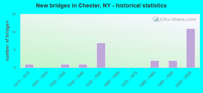
- New bridges - historical statistics
- 11910-1919
- 11930-1939
- 11940-1949
- 71950-1959
- 21980-1989
- 21990-1999
- 112000-2009

- Reconstructed bridges - Historical Statistics
- 11960-1969
- 01970-1979
- 11980-1989
- 21990-1999
- 12000-2009


- Bridge Condition - Deck
- 6.7%Very good
- 33.3%Good
- 53.3%Satisfactory
- 6.7%Fair

- Bridge Condition - Superstructure
- 5.9%Excellent
- 35.3%Very good
- 17.6%Good
- 29.4%Satisfactory
- 11.8%Fair

- Bridge Condition - Substructure
- 11.8%Very good
- 35.3%Good
- 23.5%Satisfactory
- 23.5%Fair
- 5.9%Poor

- Bridge Condition - Channel
- 10.0%Very good
- 20.0%Good
- 50.0%Satisfactory
- 20.0%Fair

- Bridge Condition - Culverts
- 50.0%Good
- 50.0%Fair
Find on map >> Show street view
Structure Number: 100318, Location: 2.6 MI E JCT US 6 & SH207 (Lat: 41.374664, Lng: -74.294636), Route carried "on" structure: Other road , Year Built: 1954, Year Reconstructed: 1991, Status: Open, Structure Length: 6.58m (21.59ft), Average Daily Traffic: 2,224 (year 2020), Truck Traffic: 4%, Average Future Daily Traffic: 2,751 (year 2040), Design Load: HS 20, Features Intersected: 17 17 83101152 WB, RTE, Facility Carried by Structure: ARCADIA ROAD
Minimum Vertical Clearance: 30+ m (98+ ft), Kilometerpoint: 0.145, Lanes on structure: 2, Lanes under structure: 4, Owner: State Highway Agency, Approaching Roadway Width: 9.1m (29.9ft), Material/Design: Steel, Design/Construction: Stringer/Multi-beam, Number Of Spans In Main Unit: 4, Length of Maximum Span: 18.2m (59.7ft), Curb-To-Curb Width: 9.1m (29.9ft), Out-to-Out Width: 10.1m (33.1ft)
Condition: Deck: Good, Superstructure: Good, Substructure: Satisfactory, Inventory Rating: 61.7 metric tons, Method Used To Determine Inventory Rating: Load Factor (LF), Structural Evaluation: Equal to present minimum criteria, Deck Geometry: Meets minimum limits, Underclear: Meets minimum limits, Approach Roadway Alignment: Equal to present desirable criteria, Length Of Structure Improvement: 6.58m (21.59ft), Designated Inspection Frequency: Every 24 months, Inspection Date: September 2021, Bridge Improvement Cost: $2,484,000, Roadway Improvement Cost: $1,454,000, Total Project Cost: $3,938,000 ( Estimate for 2021), Deck Structure Type: Concrete Cast-file-Place, Wearing Surface/Protective System: Wearing Surface: Integral Concrete, Deck Protection: Epoxy Coated Reinforcing
Find on map >> Show street view
Structure Number: 100319, Location: JCT SH 94 & US6 / SH17 (Lat: 41.358194, Lng: -74.286694), Route carried "on" structure: US 6, Year Built: 2009, Status: Open, Structure Length: 1.13m (3.71ft), Average Daily Traffic: 53,184 (year 2012), Truck Traffic: 2%, Average Future Daily Traffic: 75,026 (year 2040), Design Load: HS 25 or greater, Features Intersected: BLACK MEADOW CRK
Minimum Vertical Clearance: 30+ m (98+ ft), Kilometerpoint: 43.363, Lanes on structure: 6, Base Highway Network: Yes, Owner: State Highway Agency, Approaching Roadway Width: 30.5m (100.1ft), Skew: 24 degrees, Material/Design: Concrete, Design/Construction: Frame, Number Of Spans In Main Unit: 2, Length of Maximum Span: 5.5m (18.0ft), Curb-To-Curb Width: 30.5m (100.1ft), Out-to-Out Width: 60.3m (197.8ft)
Condition: Superstructure: Very good, Substructure: Very good, Channel: Good, Structural Evaluation: Equal to present desirable criteria, Deck Geometry: Superior to present desirable criteria, Waterway Adequacy: Equal to present minimum criteria, Approach Roadway Alignment: Equal to present desirable criteria, Length Of Structure Improvement: 1.12m (3.67ft), Designated Inspection Frequency: Every 24 months, Inspection Date: August 2021, Bridge Improvement Cost: $5,256,000, Roadway Improvement Cost: $3,078,000, Total Project Cost: $8,334,000 ( Estimate for 2021)
Find on map >> Show street view
Structure Number: 1003209, Location: JCT SH 17 & SH 94 (Lat: 41.357758, Lng: -74.286533), Route carried "on" structure: US 6, Year Built: 2008, Status: Open, Structure Length: 2.38m (7.81ft), Average Daily Traffic: 53,184 (year 2012), Truck Traffic: 2%, Average Future Daily Traffic: 75,026 (year 2040), Design Load: HL 93, Features Intersected: West Road
Minimum Vertical Clearance: 30+ m (98+ ft), Kilometerpoint: 43.411, Lanes on structure: 6, Lanes under structure: 2, Base Highway Network: Yes, Owner: State Highway Agency, Approaching Roadway Width: 15.2m (49.9ft), Skew: 20 degrees, Material/Design: Steel, Design/Construction: Stringer/Multi-beam, Number Of Spans In Main Unit: 1, Length of Maximum Span: 22.2m (72.8ft), Curb-To-Curb Width: 40.7m (133.5ft), Out-to-Out Width: 42.6m (139.8ft)
Condition: Deck: Good, Superstructure: Excellent, Substructure: Good, Operating Rating: 60.9 metric tons, Method Used To Determine Operating Rating: Load and Resistance Factor Rating (LRFR) rating reported by rating factor(RF) method using HL-93 loadings, Inventory Rating: 47.0 metric tons, Method Used To Determine Inventory Rating: Load and Resistance Factor Rating (LRFR) rating reported by rating factor(RF) method using HL-93 loadings, Structural Evaluation: Better than present minimum criteria, Deck Geometry: Superior to present desirable criteria, Underclear: High priority of corrective action, Approach Roadway Alignment: Equal to present desirable criteria, Length Of Structure Improvement: 2.37m (7.78ft), Designated Inspection Frequency: Every 24 months, Inspection Date: June 2021, Bridge Improvement Cost: $6,178,000, Roadway Improvement Cost: $3,618,000, Total Project Cost: $9,796,000 ( Estimate for 2021), Deck Structure Type: Concrete Cast-file-Place, Wearing Surface/Protective System: Wearing Surface: Integral Concrete, Deck Protection: Epoxy Coated Reinforcing
Find on map >> Show street view
Structure Number: 1003219, Location: .9 MI E JCT SH 17 & SH 94 (Lat: 41.349886, Lng: -74.275725), Route carried "on" structure: US 6, Year Built: 1956, Year Reconstructed: 1999, Status: Open, Structure Length: 7.04m (23.10ft), Truck Traffic: 2%, Design Load: HS 20, Features Intersected: MIDDLETOWN & NJ RAILROAD
Minimum Vertical Clearance: 30+ m (98+ ft), Kilometerpoint: 44.746, Lanes on structure: 4, Base Highway Network: Yes, Owner: State Highway Agency, Approaching Roadway Width: 17.4m (57.1ft), Skew: 22 degrees, Material/Design: Steel continuous, Design/Construction: Stringer/Multi-beam, Number Of Spans In Main Unit: 3, Length of Maximum Span: 30.4m (99.7ft), Curb-To-Curb Width: 34.4m (112.9ft), Out-to-Out Width: 36.1m (118.4ft)
Condition: Deck: Good, Superstructure: Satisfactory, Substructure: Fair, Operating Rating: 59.0 metric tons, Method Used To Determine Operating Rating: Load Factor (LF), Inventory Rating: 35.4 metric tons, Method Used To Determine Inventory Rating: Load Factor (LF), Structural Evaluation: Somewhat better than minimum adequacy, Deck Geometry: Superior to present desirable criteria, Underclear: Somewhat better than minimum adequacy, Approach Roadway Alignment: Equal to present desirable criteria, Length Of Structure Improvement: 7.04m (23.10ft), Designated Inspection Frequency: Every 24 months, Inspection Date: December 2021, Bridge Improvement Cost: $10,250,000, Roadway Improvement Cost: $6,002,000, Total Project Cost: $16,252,000 ( Estimate for 2021), Deck Structure Type: Concrete Cast-file-Place, Wearing Surface/Protective System: Wearing Surface: Integral Concrete, Deck Protection: Epoxy Coated Reinforcing
Find on map >> Show street view
Structure Number: 1003229, Location: 1.0 MI E JCT RTS 17+94 (Lat: 41.349797, Lng: -74.274553), Route carried "on" structure: US 17, Year Built: 1956, Year Reconstructed: 1996, Status: Open, Structure Length: 5.64m (18.50ft), Truck Traffic: 2%, Design Load: HS 20, Features Intersected: COUNTY ROAD 13
Minimum Vertical Clearance: 30+ m (98+ ft), Kilometerpoint: 44.843, Lanes on structure: 4, Lanes under structure: 2, Base Highway Network: Yes, Owner: State Highway Agency, Approaching Roadway Width: 16.5m (54.1ft), Skew: 22 degrees, Material/Design: Steel, Design/Construction: Stringer/Multi-beam, Number Of Spans In Main Unit: 3, Length of Maximum Span: 19.5m (64.0ft), Curb-To-Curb Width: 34.5m (113.2ft), Out-to-Out Width: 36.1m (118.4ft)
Condition: Deck: Good, Superstructure: Good, Substructure: Fair, Operating Rating: 78.9 metric tons, Method Used To Determine Operating Rating: Load Factor (LF), Inventory Rating: 47.2 metric tons, Method Used To Determine Inventory Rating: Load Factor (LF), Structural Evaluation: Somewhat better than minimum adequacy, Deck Geometry: Superior to present desirable criteria, Underclear: Meets minimum limits, Approach Roadway Alignment: Equal to present desirable criteria, Length Of Structure Improvement: 5.63m (18.47ft), Designated Inspection Frequency: Every 24 months, Inspection Date: April 2021, Bridge Improvement Cost: $8,154,000, Roadway Improvement Cost: $4,775,000, Total Project Cost: $12,930,000 ( Estimate for 2021), Deck Structure Type: Concrete Cast-file-Place, Wearing Surface/Protective System: Wearing Surface: Integral Concrete, Deck Protection: Epoxy Coated Reinforcing
Find on map >> Show street view
Structure Number: 100323, Location: 1.3 MI E JCT SH 17 & SH94 (Lat: 41.350939, Lng: -74.268158), Route carried "on" structure: State highway 17M, Year Built: 2006, Status: Open, Structure Length: 7.22m (23.69ft), Average Daily Traffic: 6,981 (year 2018), Truck Traffic: 6%, Average Future Daily Traffic: 8,637 (year 2040), Design Load: HS 25 or greater, Features Intersected: 17 17 83101177, RTE 17
Minimum Vertical Clearance: 30+ m (98+ ft), Kilometerpoint: 28.930, Lanes on structure: 2, Lanes under structure: 4, Base Highway Network: Yes, Owner: State Highway Agency, Approaching Roadway Width: 10.7m (35.1ft), Skew: 4 degrees, Material/Design: Steel continuous, Design/Construction: Stringer/Multi-beam, Number Of Spans In Main Unit: 2, Length of Maximum Span: 35.1m (115.2ft), Curb-To-Curb Width: 10.8m (35.4ft), Out-to-Out Width: 11.7m (38.4ft)
Condition: Deck: Satisfactory, Superstructure: Very good, Substructure: Very good, Operating Rating: 45.0 metric tons, Method Used To Determine Operating Rating: Load and Resistance Factor Rating (LRFR) rating reported by rating factor(RF) method using HL-93 loadings, Inventory Rating: 34.7 metric tons, Method Used To Determine Inventory Rating: Load and Resistance Factor Rating (LRFR) rating reported by rating factor(RF) method using HL-93 loadings, Structural Evaluation: Equal to present desirable criteria, Deck Geometry: Meets minimum limits, Underclear: Equal to present desirable criteria, Approach Roadway Alignment: Equal to present desirable criteria, Length Of Structure Improvement: 7.22m (23.69ft), Designated Inspection Frequency: Every 24 months, Inspection Date: July 2020, Bridge Improvement Cost: $4,565,000, Roadway Improvement Cost: $2,673,000, Total Project Cost: $7,238,000 ( Estimate for 2021), Deck Structure Type: Concrete Cast-file-Place, Wearing Surface/Protective System: Wearing Surface: Integral Concrete, Deck Protection: Epoxy Coated Reinforcing
Find on map >> Show street view
Structure Number: 100324, Location: 2.7 MI E JCT RTS 17+94 (Lat: 41.352264, Lng: -74.243028), Route carried "on" structure: US 6, Year Built: 1956, Status: Open, Structure Length: 2.32m (7.61ft), Average Daily Traffic: 52,825 (year 2020), Truck Traffic: 2%, Average Future Daily Traffic: 74,520 (year 2040), Design Load: HS 20, Features Intersected: SEELY BROOK
Minimum Vertical Clearance: 30+ m (98+ ft), Kilometerpoint: 47.675, Lanes on structure: 4, Base Highway Network: Yes, Owner: State Highway Agency, Approaching Roadway Width: 23.2m (76.1ft), Skew: 24 degrees, Material/Design: Concrete continuous, Design/Construction: Culvert, Number Of Spans In Main Unit: 2, Length of Maximum Span: 10.3m (33.8ft)
Condition: Channel: Fair, Culverts: Fair, Operating Rating: 53.5 metric tons, Method Used To Determine Operating Rating: Load Factor (LF), Inventory Rating: 31.8 metric tons, Method Used To Determine Inventory Rating: Load Factor (LF), Structural Evaluation: Somewhat better than minimum adequacy, Waterway Adequacy: Superior to present desirable criteria, Approach Roadway Alignment: Equal to present desirable criteria, Length Of Structure Improvement: 2.31m (7.58ft), Designated Inspection Frequency: Every 24 months, Inspection Date: July 2021, Bridge Improvement Cost: $1,842,000, Roadway Improvement Cost: $1,079,000, Total Project Cost: $2,921,000 ( Estimate for 2021)
Find on map >> Show street view
Structure Number: 101457, Location: 0.6 MI N JCT RTS 17M & 94 (Lat: 41.365908, Lng: -74.288744), Route carried "on" structure: State highway 17M, Year Built: 1994, Status: Open, Structure Length: 2.23m (7.32ft), Average Daily Traffic: 6,092 (year 2020), Truck Traffic: 3%, Average Future Daily Traffic: 7,537 (year 2040), Design Load: HS 25 or greater, Features Intersected: BLACK MEADOW CREEK
Minimum Vertical Clearance: 30+ m (98+ ft), Kilometerpoint: 26.307, Lanes on structure: 2, Base Highway Network: Yes, Owner: State Highway Agency, Approaching Roadway Width: 12.2m (40.0ft), Material/Design: Prestressed concrete, Design/Construction: Box Beam or Girders - Multiple, Number Of Spans In Main Unit: 1, Length of Maximum Span: 21.3m (69.9ft), Curb-To-Curb Width: 12.2m (40.0ft), Out-to-Out Width: 12.8m (42.0ft)
Condition: Deck: Satisfactory, Superstructure: Satisfactory, Substructure: Satisfactory, Channel: Satisfactory, Operating Rating: 88.9 metric tons, Method Used To Determine Operating Rating: Load Factor (LF), Inventory Rating: 47.2 metric tons, Method Used To Determine Inventory Rating: Load Factor (LF), Structural Evaluation: Equal to present minimum criteria, Deck Geometry: Somewhat better than minimum adequacy, Waterway Adequacy: Superior to present desirable criteria, Approach Roadway Alignment: Equal to present minimum criteria, Length Of Structure Improvement: 2.22m (7.28ft), Designated Inspection Frequency: Every 24 months, Inspection Date: December 2020, Bridge Improvement Cost: $784,000, Roadway Improvement Cost: $459,000, Total Project Cost: $1,243,000 ( Estimate for 2021), Wearing Surface/Protective System: Wearing Surface: Bituminous
Find on map >> Show street view
Structure Number: 101458, Location: .6 MI S JCT SH17M & SH 94 (Lat: 41.351606, Lng: -74.272739), Route carried "on" structure: State highway 17M, Year Built: 1941, Year Reconstructed: 1973, Status: Open, Structure Length: 5.30m (17.39ft), Average Daily Traffic: 10,542 (year 2016), Truck Traffic: 5%, Average Future Daily Traffic: 13,043 (year 2040), Design Load: H 20, Features Intersected: NORFOLK SOUTHERN/NJ TRAN
Minimum Vertical Clearance: 30+ m (98+ ft), Kilometerpoint: 28.528, Lanes on structure: 2, Base Highway Network: Yes, Owner: State Highway Agency, Approaching Roadway Width: 12.2m (40.0ft), Skew: 4 degrees, Material/Design: Steel, Design/Construction: Stringer/Multi-beam, Number Of Spans In Main Unit: 3, Length of Maximum Span: 19.8m (65.0ft), Curb-To-Curb Width: 13.5m (44.3ft), Out-to-Out Width: 14.4m (47.2ft)
Condition: Deck: Satisfactory, Superstructure: Satisfactory, Substructure: Fair, Operating Rating: 51.7 metric tons, Method Used To Determine Operating Rating: Load Factor (LF), Inventory Rating: 30.8 metric tons, Method Used To Determine Inventory Rating: Load Factor (LF), Structural Evaluation: Somewhat better than minimum adequacy, Deck Geometry: Superior to present desirable criteria, Underclear: Somewhat better than minimum adequacy, Approach Roadway Alignment: Meets minimum limits, Length Of Structure Improvement: 5.30m (17.39ft), Designated Inspection Frequency: Every 24 months, Inspection Date: December 2021, Bridge Improvement Cost: $4,238,000, Roadway Improvement Cost: $2,482,000, Total Project Cost: $6,720,000 ( Estimate for 2021), Deck Structure Type: Concrete Cast-file-Place, Wearing Surface/Protective System: Wearing Surface: Bituminous
Find on map >> Show street view
Structure Number: 101459, Location: 3.2 MI W JCT RTS 17M+208 (Lat: 41.350528, Lng: -74.240869), Route carried "on" structure: State highway 17M, Year Built: 1935, Year Reconstructed: 2007, Status: Open, Structure Length: 2.87m (9.42ft), Average Daily Traffic: 4,604 (year 2016), Truck Traffic: 5%, Average Future Daily Traffic: 5,696 (year 2040), Design Load: HS 25 or greater, Features Intersected: SEELY BROOK
Minimum Vertical Clearance: 30+ m (98+ ft), Kilometerpoint: 31.488, Lanes on structure: 2, Base Highway Network: Yes, Owner: State Highway Agency, Approaching Roadway Width: 11.9m (39.0ft), Skew: 4 degrees, Material/Design: Steel, Design/Construction: Stringer/Multi-beam, Number Of Spans In Main Unit: 1, Length of Maximum Span: 26.2m (86.0ft), Curb-To-Curb Width: 12.1m (39.7ft), Out-to-Out Width: 13.0m (42.7ft)
Condition: Deck: Satisfactory, Superstructure: Very good, Substructure: Good, Channel: Satisfactory, Inventory Rating: 66.2 metric tons, Method Used To Determine Inventory Rating: Load Factor (LF), Structural Evaluation: Better than present minimum criteria, Deck Geometry: Somewhat better than minimum adequacy, Waterway Adequacy: Meets minimum limits, Approach Roadway Alignment: Equal to present desirable criteria, Length Of Structure Improvement: 2.86m (9.38ft), Designated Inspection Frequency: Every 24 months, Inspection Date: June 2021, Bridge Improvement Cost: $2,518,000, Roadway Improvement Cost: $1,475,000, Total Project Cost: $3,993,000 ( Estimate for 2021), Deck Structure Type: Concrete Cast-file-Place, Wearing Surface/Protective System: Wearing Surface: Integral Concrete, Deck Protection: Epoxy Coated Reinforcing
Find on map >> Show street view
Structure Number: 103482, Location: .1 MI W JCT SH 94 & SH17M (Lat: 41.357711, Lng: -74.287056), Route carried "on" structure: ServiceOther road , Year Built: 2008, Status: Open, Structure Length: 1.55m (5.09ft), Average Daily Traffic: 4,510 (year 2020), Truck Traffic: 3%, Average Future Daily Traffic: 6,314 (year 2040), Design Load: HS 25 or greater, Features Intersected: BLACK MEADOW CREEK, Facility Carried by Structure: WEST AVENUE
Minimum Vertical Clearance: 30+ m (98+ ft), Kilometerpoint: 0.628, Lanes on structure: 2, Owner: State Highway Agency, Approaching Roadway Width: 9.1m (29.9ft), Material/Design: Concrete, Design/Construction: Frame, Number Of Spans In Main Unit: 1, Length of Maximum Span: 9.1m (29.9ft), Curb or Sidewalk Widths: Left: 1.7m (5.6ft), Right: 0.0m, Curb-To-Curb Width: 9.1m (29.9ft), Out-to-Out Width: 11.8m (38.7ft)
Condition: Superstructure: Good, Substructure: Good, Channel: Satisfactory, Operating Rating: 77.1 metric tons, Method Used To Determine Operating Rating: Load Factor (LF), Inventory Rating: 49.0 metric tons, Method Used To Determine Inventory Rating: Load Factor (LF), Structural Evaluation: Better than present minimum criteria, Deck Geometry: Meets minimum limits, Waterway Adequacy: Superior to present desirable criteria, Approach Roadway Alignment: Equal to present desirable criteria, Length Of Structure Improvement: 1.55m (5.09ft), Designated Inspection Frequency: Every 24 months, Inspection Date: October 2020, Bridge Improvement Cost: $912,000, Roadway Improvement Cost: $534,000, Total Project Cost: $1,447,000 ( Estimate for 2021), Wearing Surface/Protective System: Wearing Surface: Bituminous
Find on map >> Show street view
Structure Number: 103483, Location: .9 MI E JCT SH 94 & SH17M (Lat: 41.364025, Lng: -74.271883), Route carried "on" structure: State highway 94, Year Built: 1950, Status: Open, Structure Length: 4.48m (14.70ft), Average Daily Traffic: 4,827 (year 2020), Truck Traffic: 5%, Average Future Daily Traffic: 5,863 (year 2040), Design Load: HS 20, Features Intersected: ORANGE CO TRAILWAY
Minimum Vertical Clearance: 30+ m (98+ ft), Kilometerpoint: 24.923, Lanes on structure: 2, Base Highway Network: Yes, Owner: State Highway Agency, Approaching Roadway Width: 9.8m (32.2ft), Material/Design: Steel, Design/Construction: Stringer/Multi-beam, Number Of Spans In Main Unit: 3, Length of Maximum Span: 15.2m (49.9ft), Curb or Sidewalk Widths: Left: 1.5m (4.9ft), Right: 1.5m (4.9ft), Curb-To-Curb Width: 9.8m (32.2ft), Out-to-Out Width: 13.5m (44.3ft)
Condition: Deck: Satisfactory, Superstructure: Fair, Substructure: Poor, Operating Rating: 46.3 metric tons, Method Used To Determine Operating Rating: Load Factor (LF), Inventory Rating: 27.2 metric tons, Method Used To Determine Inventory Rating: Load Factor (LF), Structural Evaluation: Meets minimum limits, Deck Geometry: Meets minimum limits, Approach Roadway Alignment: Meets minimum limits, Length Of Structure Improvement: 4.48m (14.70ft), Designated Inspection Frequency: Every 24 months, Inspection Date: November 2021, Bridge Improvement Cost: $2,868,000, Roadway Improvement Cost: $1,679,000, Total Project Cost: $4,547,000 ( Estimate for 2021), Deck Structure Type: Concrete Cast-file-Place, Wearing Surface/Protective System: Wearing Surface: Integral Concrete
Find on map >> Show street view
Structure Number: 10776, Location: .3 MI SE JCT SH 17 & SH94 (Lat: 41.354442, Lng: -74.290431), Route carried "on" structure: Alternate State highway 94, Year Built: 2004, Status: Open, Structure Length: 2.87m (9.42ft), Average Daily Traffic: 6,687 (year 2017), Truck Traffic: 7%, Average Future Daily Traffic: 8,123 (year 2040), Design Load: HS 25 or greater, Features Intersected: BLACK MEADOW CREEK
Minimum Vertical Clearance: 30+ m (98+ ft), Kilometerpoint: 22.751, Lanes on structure: 2, Base Highway Network: Yes, Owner: State Highway Agency, Approaching Roadway Width: 14.3m (46.9ft), Skew: 22 degrees, Material/Design: Prestressed concrete, Design/Construction: Stringer/Multi-beam, Number Of Spans In Main Unit: 1, Length of Maximum Span: 28.2m (92.5ft), Curb or Sidewalk Widths: Left: 0.0m, Right: 1.6m (5.2ft), Curb-To-Curb Width: 12.6m (41.3ft), Out-to-Out Width: 15.7m (51.5ft)
Condition: Deck: Satisfactory, Superstructure: Very good, Substructure: Satisfactory, Channel: Good, Operating Rating: 82.6 metric tons, Method Used To Determine Operating Rating: Load and Resistance Factor Rating (LRFR) rating reported by rating factor(RF) method using HL-93 loadings, Inventory Rating: 63.8 metric tons, Method Used To Determine Inventory Rating: Load and Resistance Factor Rating (LRFR) rating reported by rating factor(RF) method using HL-93 loadings, Structural Evaluation: Equal to present minimum criteria, Deck Geometry: Somewhat better than minimum adequacy, Waterway Adequacy: Superior to present desirable criteria, Approach Roadway Alignment: Equal to present desirable criteria, Length Of Structure Improvement: 2.86m (9.38ft), Designated Inspection Frequency: Every 24 months, Inspection Date: September 2020, Bridge Improvement Cost: $1,343,000, Roadway Improvement Cost: $786,000, Total Project Cost: $2,129,000 ( Estimate for 2021), Deck Structure Type: Concrete Cast-file-Place, Wearing Surface/Protective System: Wearing Surface: Integral Concrete, Deck Protection: Epoxy Coated Reinforcing
Find on map >> Show street view
Structure Number: 107761, Location: JCT SH 17 & SH 94 (Lat: 41.354606, Lng: -74.284622), Route carried "on" structure: Alternate State highway 94, Year Built: 2004, Status: Open, Structure Length: 5.09m (16.70ft), Average Daily Traffic: 15,453 (year 2017), Truck Traffic: 4%, Average Future Daily Traffic: 18,772 (year 2040), Design Load: HS 25 or greater, Features Intersected: 6 17 83101169, RTE 6
Minimum Vertical Clearance: 30+ m (98+ ft), Kilometerpoint: 23.234, Lanes on structure: 4, Lanes under structure: 4, Base Highway Network: Yes, Owner: State Highway Agency, Approaching Roadway Width: 16.2m (53.1ft), Material/Design: Prestressed concrete continuous, Design/Construction: Stringer/Multi-beam, Number Of Spans In Main Unit: 2, Length of Maximum Span: 25.0m (82.0ft), Curb or Sidewalk Widths: Left: 0.0m, Right: 1.6m (5.2ft), Curb-To-Curb Width: 16.2m (53.1ft), Out-to-Out Width: 18.8m (61.7ft)
Condition: Deck: Satisfactory, Superstructure: Very good, Substructure: Good, Operating Rating: 91.8 metric tons, Method Used To Determine Operating Rating: Load Factor (LF), Inventory Rating: 55.0 metric tons, Method Used To Determine Inventory Rating: Load Factor (LF), Structural Evaluation: Better than present minimum criteria, Deck Geometry: Meets minimum limits, Underclear: Superior to present desirable criteria, Approach Roadway Alignment: Equal to present desirable criteria, Length Of Structure Improvement: 5.09m (16.70ft), Designated Inspection Frequency: Every 24 months, Inspection Date: August 2020, Bridge Improvement Cost: $5,025,000, Roadway Improvement Cost: $2,943,000, Total Project Cost: $7,968,000 ( Estimate for 2021), Deck Structure Type: Concrete Cast-file-Place, Wearing Surface/Protective System: Wearing Surface: Monolithic Concrete, Deck Protection: Galvanized Reinforcing
Find on map >> Show street view
Structure Number: 22231, Location: WEST OF CHESTER TOWN LINE (Lat: 41.359019, Lng: -74.239758), Route carried "on" structure: Other road , Year Built: 1980, Status: Open, Structure Length: 8.02m (26.31ft), Average Daily Traffic: 601 (year 2015), Truck Traffic: 8%, Average Future Daily Traffic: 841 (year 2035), Design Load: HS 20, Features Intersected: HERITAGE TRAIL, Facility Carried by Structure: GREYCOURT RD
Minimum Vertical Clearance: 30+ m (98+ ft), Kilometerpoint: 1.448, Lanes on structure: 2, Owner: County Highway Agency, Approaching Roadway Width: 10.4m (34.1ft), Skew: 3 degrees, Material/Design: Steel continuous, Design/Construction: Stringer/Multi-beam, Number Of Spans In Main Unit: 3, Length of Maximum Span: 36.8m (120.7ft), Curb-To-Curb Width: 10.2m (33.5ft), Out-to-Out Width: 11.4m (37.4ft)
Condition: Deck: Very good, Superstructure: Very good, Substructure: Fair, Operating Rating: 53.1 metric tons, Method Used To Determine Operating Rating: Load and Resistance Factor Rating (LRFR) rating reported by rating factor(RF) method using HL-93 loadings, Inventory Rating: 40.8 metric tons, Method Used To Determine Inventory Rating: Load and Resistance Factor Rating (LRFR) rating reported by rating factor(RF) method using HL-93 loadings, Structural Evaluation: Somewhat better than minimum adequacy, Deck Geometry: Equal to present minimum criteria, Approach Roadway Alignment: Equal to present desirable criteria, Length Of Structure Improvement: 8.01m (26.28ft), Designated Inspection Frequency: Every 24 months, Inspection Date: October 2020, Bridge Improvement Cost: $3,618,000, Roadway Improvement Cost: $2,119,000, Total Project Cost: $5,737,000 ( Estimate for 2021), Deck Structure Type: Concrete Cast-file-Place, Wearing Surface/Protective System: Wearing Surface: Integral Concrete, Deck Protection: Epoxy Coated Reinforcing
Find on map >> Show street view
Structure Number: 226963, Location: 1.4 MI JCT SH 17M & SH 94 (Lat: 41.348933, Lng: -74.286783), Route carried "on" structure: Business Other road , Year Built: 1985, Status: Open, Structure Length: 1.92m (6.30ft), Truck Traffic: 4%, Features Intersected: TRIBUTARY BLACK MEADOW C, Facility Carried by Structure: ELIZABETH DRIVE
Minimum Vertical Clearance: 30+ m (98+ ft), Kilometerpoint: 0.129, Lanes on structure: 2, Owner: Town or Township Highway Agency, Approaching Roadway Width: 9.1m (29.9ft), Material/Design: Concrete, Design/Construction: Slab, Number Of Spans In Main Unit: 3, Length of Maximum Span: 6.1m (20.0ft), Curb or Sidewalk Widths: Left: 0.9m (3.0ft), Right: 0.9m (3.0ft), Curb-To-Curb Width: 9.2m (30.2ft), Out-to-Out Width: 11.5m (37.7ft)
Condition: Deck: Fair, Superstructure: Fair, Substructure: Good, Channel: Very good, Operating Rating: 24.0 metric tons, Method Used To Determine Operating Rating: Load and Resistance Factor Rating (LRFR) rating reported by rating factor(RF) method using HL-93 loadings, Inventory Rating: 18.5 metric tons, Method Used To Determine Inventory Rating: Load and Resistance Factor Rating (LRFR) rating reported by rating factor(RF) method using HL-93 loadings, Structural Evaluation: Somewhat better than minimum adequacy, Deck Geometry: Better than present minimum criteria, Waterway Adequacy: Equal to present minimum criteria, Approach Roadway Alignment: Equal to present minimum criteria, Length Of Structure Improvement: 1.92m (6.30ft), Designated Inspection Frequency: Every 24 months, Inspection Date: August 2021, Bridge Improvement Cost: $475,000, Roadway Improvement Cost: $278,000, Total Project Cost: $754,000 ( Estimate for 2021), Wearing Surface/Protective System: Wearing Surface: Integral Concrete
Find on map >> Show street view
Structure Number: 334424, Location: 1 MILE EAST OF CHESTER (Lat: 41.357450, Lng: -74.254158), Route carried "on" structure: Other road , Year Built: 1991, Status: Open, Structure Length: 2.04m (6.69ft), Average Daily Traffic: 601 (year 2015), Truck Traffic: 8%, Average Future Daily Traffic: 841 (year 2035), Features Intersected: SEELY BROOK, Facility Carried by Structure: OLD OXFORD ROAD
Minimum Vertical Clearance: 30+ m (98+ ft), Kilometerpoint: 0.225, Lanes on structure: 2, Owner: County Highway Agency, Approaching Roadway Width: 9.1m (29.9ft), Material/Design: Steel, Design/Construction: Stringer/Multi-beam, Number Of Spans In Main Unit: 1, Length of Maximum Span: 18.8m (61.7ft), Curb-To-Curb Width: 9.1m (29.9ft), Out-to-Out Width: 9.8m (32.2ft)
Condition: Deck: Good, Superstructure: Satisfactory, Substructure: Satisfactory, Channel: Satisfactory, Operating Rating: 97.2 metric tons, Method Used To Determine Operating Rating: Load and Resistance Factor Rating (LRFR) rating reported by rating factor(RF) method using HL-93 loadings, Inventory Rating: 97.2 metric tons, Method Used To Determine Inventory Rating: Load and Resistance Factor Rating (LRFR) rating reported by rating factor(RF) method using HL-93 loadings, Structural Evaluation: Equal to present minimum criteria, Deck Geometry: Equal to present minimum criteria, Waterway Adequacy: Equal to present desirable criteria, Approach Roadway Alignment: Equal to present desirable criteria, Length Of Structure Improvement: 2.04m (6.69ft), Designated Inspection Frequency: Every 24 months, Inspection Date: April 2020, Bridge Improvement Cost: $1,092,000, Roadway Improvement Cost: $639,000, Total Project Cost: $1,731,000 ( Estimate for 2021), Deck Structure Type: Concrete Cast-file-Place, Wearing Surface/Protective System: Wearing Surface: Bituminous, Deck Protection: Epoxy Coated Reinforcing
Find on map >> Show street view
Structure Number: 334426, Location: 1 MI NW OF CHESTER (Lat: 41.371892, Lng: -74.283475), Route carried "on" structure: Other road , Year Built: 2002, Status: Open, Structure Length: 1.58m (5.18ft), Average Daily Traffic: 1,055 (year 2016), Truck Traffic: 2%, Average Future Daily Traffic: 1,477 (year 2036), Design Load: HS 25 or greater, Features Intersected: BLACK MEADOW CREEK, Facility Carried by Structure: HAMBLETONIAN AVENU
Minimum Vertical Clearance: 30+ m (98+ ft), Kilometerpoint: 1.094, Lanes on structure: 2, Owner: County Highway Agency, Approaching Roadway Width: 7.9m (25.9ft), Material/Design: Concrete, Design/Construction: Culvert, Number Of Spans In Main Unit: 2, Length of Maximum Span: 7.3m (24.0ft), Curb-To-Curb Width: 8.5m (27.9ft), Out-to-Out Width: 9.8m (32.2ft)
Condition: Channel: Fair, Culverts: Good, Operating Rating: 69.9 metric tons, Method Used To Determine Operating Rating: Load Factor (LF), Inventory Rating: 41.7 metric tons, Method Used To Determine Inventory Rating: Load Factor (LF), Structural Evaluation: Better than present minimum criteria, Deck Geometry: Somewhat better than minimum adequacy, Waterway Adequacy: Somewhat better than minimum adequacy, Approach Roadway Alignment: Equal to present desirable criteria, Length Of Structure Improvement: 1.58m (5.18ft), Designated Inspection Frequency: Every 24 months, Inspection Date: April 2021, Bridge Improvement Cost: $780,000, Roadway Improvement Cost: $457,000, Total Project Cost: $1,237,000 ( Estimate for 2021)
Find on map >> Show street view
Structure Number: 334456, Location: 2.5 MI SE OF GOSHEN (Lat: 41.382931, Lng: -74.291467), Route carried "on" structure: Other road , Year Built: 2004, Status: Open, Structure Length: 1.13m (3.71ft), Average Daily Traffic: 1,665 (year 2020), Truck Traffic: 3%, Average Future Daily Traffic: 2,331 (year 2040), Design Load: HS 25 or greater, Features Intersected: BLACK MEADOW CRK, Facility Carried by Structure: KNOELL ROAD
Minimum Vertical Clearance: 30+ m (98+ ft), Kilometerpoint: 1.641, Lanes on structure: 2, Owner: County Highway Agency, Approaching Roadway Width: 8.2m (26.9ft), Skew: 2 degrees, Material/Design: Concrete, Design/Construction: Frame, Number Of Spans In Main Unit: 1, Length of Maximum Span: 10.4m (34.1ft), Curb-To-Curb Width: 8.5m (27.9ft), Out-to-Out Width: 9.5m (31.2ft)
Condition: Deck: Satisfactory, Superstructure: Satisfactory, Substructure: Good, Channel: Satisfactory, Operating Rating: 77.1 metric tons, Method Used To Determine Operating Rating: Load Factor (LF), Inventory Rating: 46.3 metric tons, Method Used To Determine Inventory Rating: Load Factor (LF), Structural Evaluation: Equal to present minimum criteria, Deck Geometry: Somewhat better than minimum adequacy, Waterway Adequacy: Superior to present desirable criteria, Approach Roadway Alignment: Equal to present desirable criteria, Length Of Structure Improvement: 1.12m (3.67ft), Designated Inspection Frequency: Every 24 months, Inspection Date: August 2020, Bridge Improvement Cost: $582,000, Roadway Improvement Cost: $341,000, Total Project Cost: $923,000 ( Estimate for 2021), Wearing Surface/Protective System: Wearing Surface: Bituminous, Membrane: Other
Find on map >> Show street view
Structure Number: 100318, Location: 2.6 MI E JCT US 6 & SH207 (Lat: 41.374664, Lng: -74.294636), Route carried "under" structure: US 17, Year Built: 1954, Structure Length: 0. m, Average Daily Traffic: 38,470 (year 1998), Features Intersected: 17 17 83101152 WB, RTE, Facility Carried by Structure: ARCADIA ROAD
Minimum Vertical Clearance: 6.35m (20.83ft), Kilometerpoint: 24.537, Lanes on structure: 2, Lanes under structure: 2, Material/Design: Steel, Design/Construction: Stringer/Multi-beam, Length of Maximum Span: 18.2m (59.7ft)
Find on map >> Show street view
Structure Number: 1003209, Location: JCT SH 17 & SH 94 (Lat: 41.357758, Lng: -74.286533), Route carried "under" structure: ServiceState highway , Year Built: 2008, Structure Length: 0. m, Average Daily Traffic: 3,400 (year 1979), Features Intersected: West Road, Facility Carried by Structure: RTE 6
Minimum Vertical Clearance: 5.08m (16.67ft), Kilometerpoint: 0.000, Lanes on structure: 6, Lanes under structure: 2, Material/Design: Steel, Design/Construction: Stringer/Multi-beam, Length of Maximum Span: 22.2m (72.8ft)
Find on map >> Show street view
Structure Number: 1003229, Location: 1.0 MI E JCT RTS 17+94 (Lat: 41.349797, Lng: -74.274553), Route carried "under" structure: County highway , Year Built: 1956, Structure Length: 0. m, Average Daily Traffic: 10,000 (year 2021), Features Intersected: COUNTY ROAD 13, Facility Carried by Structure: RTE 17
Minimum Vertical Clearance: 7.80m (25.59ft), Kilometerpoint: 0.000, Lanes on structure: 4, Lanes under structure: 2, Material/Design: Steel, Design/Construction: Stringer/Multi-beam, Length of Maximum Span: 19.5m (64.0ft)
Find on map >> Show street view
Structure Number: 100323, Location: 1.3 MI E JCT SH 17 & SH94 (Lat: 41.350939, Lng: -74.268158), Route carried "under" structure: US 17, Year Built: 2006, Structure Length: 0. m, Average Daily Traffic: 46,500 (year 2003), Features Intersected: 17 17 83101177, RTE 17
Minimum Vertical Clearance: 5.18m (16.99ft), Kilometerpoint: 600.157, Lanes on structure: 2, Lanes under structure: 2, Material/Design: Steel continuous, Design/Construction: Stringer/Multi-beam, Length of Maximum Span: 35.1m (115.2ft)
Find on map >> Show street view
Structure Number: 107761, Location: JCT SH 17 & SH 94 (Lat: 41.354606, Lng: -74.284622), Route carried "under" structure: US 6, Year Built: 2004, Structure Length: 0. m, Average Daily Traffic: 43,083 (year 2000), Features Intersected: 6 17 83101169, RTE 6, Facility Carried by Structure: RTE 94
Minimum Vertical Clearance: 5.85m (19.19ft), Kilometerpoint: 598.548, Lanes on structure: 4, Lanes under structure: 2, Material/Design: Prestressed concrete continuous, Design/Construction: Stringer/Multi-beam, Length of Maximum Span: 25.0m (82.0ft)
Find on map >> Show street view
Structure Number: 77121, Location: AT CHESTER (Lat: 41.362558, Lng: -74.269219), Route carried "under" structure: Other road , Year Built: 1915, Structure Length: 0. m, Features Intersected: MEADOW AVENUE, Facility Carried by Structure: EX ERIE RAILROAD
Minimum Vertical Clearance: 3.65m (11.98ft), Kilometerpoint: 0.000, Lanes under structure: 2, Material/Design: Steel, Design/Construction: Girder and Floorbeam System, Length of Maximum Span: 10.3m (33.8ft)