Bridge Statistics for Chestnut Ridge, New York (NY)
Condition, Traffic, Stress, Structural Evaluation, Project Costs
- National Bridge Inventory (NBI) Statistics
- 20Number of bridges
- 203ft / 62.1mTotal length
- $44,495,000Total costs
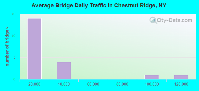
- 339,364Total average daily traffic
- 15,110Total average daily truck traffic
- National Bridge Inventory (NBI) Registered Bridges for Chestnut Ridge
- No street view available for this location
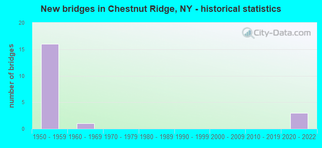
- New bridges - historical statistics
- 161950-1959
- 11960-1969
- 32020-2022
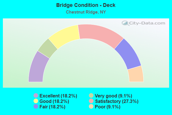
- Bridge Condition - Deck
- 18.2%Excellent
- 9.1%Very good
- 18.2%Good
- 27.3%Satisfactory
- 18.2%Fair
- 9.1%Poor
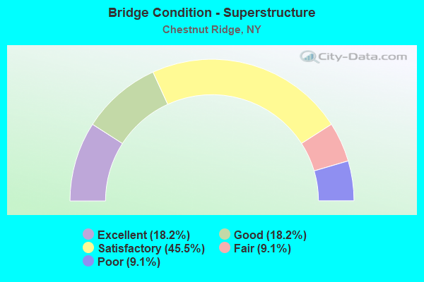
- Bridge Condition - Superstructure
- 18.2%Excellent
- 18.2%Good
- 45.5%Satisfactory
- 9.1%Fair
- 9.1%Poor
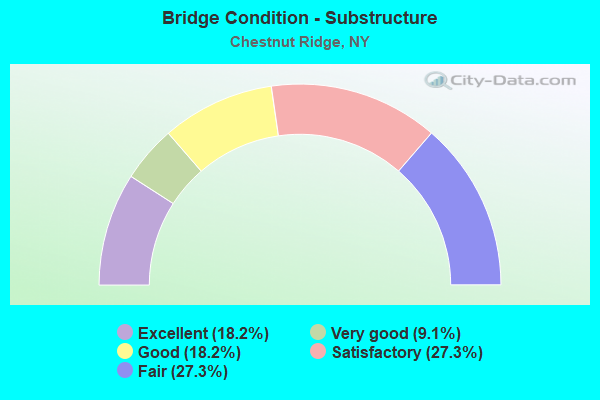
- Bridge Condition - Substructure
- 18.2%Excellent
- 9.1%Very good
- 18.2%Good
- 27.3%Satisfactory
- 27.3%Fair
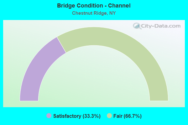
- Bridge Condition - Channel
- 33.3%Satisfactory
- 66.7%Fair
Find on map >> Show street view
Structure Number: 322416, Location: 6.2 MI SW OF NYACK (Lat: 41.083514, Lng: -74.041653), Route carried "on" structure: Other road , Year Built: 1960, Status: Open, Structure Length: 0.85m (2.79ft), Average Daily Traffic: 606 (year 2018), Truck Traffic: 4%, Average Future Daily Traffic: 848 (year 2038), Features Intersected: PASCACK BROOK, Facility Carried by Structure: LILLIAN DRIVE
Minimum Vertical Clearance: 30+ m (98+ ft), Kilometerpoint: 0.032, Lanes on structure: 2, Owner: Town or Township Highway Agency, Approaching Roadway Width: 8.8m (28.9ft), Material/Design: Concrete, Design/Construction: Tee Beam, Number Of Spans In Main Unit: 1, Length of Maximum Span: 8.2m (26.9ft), Curb or Sidewalk Widths: Left: 1.5m (4.9ft), Right: 1.5m (4.9ft), Curb-To-Curb Width: 9.1m (29.9ft), Out-to-Out Width: 12.2m (40.0ft)
Condition: Deck: Satisfactory, Superstructure: Satisfactory, Substructure: Satisfactory, Channel: Fair, Operating Rating: 78.4 metric tons, Method Used To Determine Operating Rating: Field evaluation and documented engineering judgment, Inventory Rating: 32.7 metric tons, Method Used To Determine Inventory Rating: Field evaluation and documented engineering judgment, Structural Evaluation: Equal to present minimum criteria, Deck Geometry: Equal to present minimum criteria, Waterway Adequacy: Meets minimum limits, Approach Roadway Alignment: Equal to present minimum criteria, Length Of Structure Improvement: 0.85m (2.79ft), Designated Inspection Frequency: Every 24 months, Inspection Date: June 2021, Bridge Improvement Cost: $544,000, Roadway Improvement Cost: $319,000, Total Project Cost: $863,000 ( Estimate for 2021), Deck Structure Type: Concrete Cast-file-Place, Wearing Surface/Protective System: Wearing Surface: Bituminous
Find on map >> Show street view
Structure Number: 334619, Location: 3.4 MI S OF SPRING VALLEY (Lat: 41.067469, Lng: -74.039528), Route carried "on" structure: County highway , Year Built: 1950, Status: Open, Structure Length: 1.28m (4.20ft), Average Daily Traffic: 2,572 (year 2017), Truck Traffic: 4%, Average Future Daily Traffic: 3,124 (year 2040), Features Intersected: PASCACK BROOK, Facility Carried by Structure: PASCACK ROAD
Minimum Vertical Clearance: 30+ m (98+ ft), Kilometerpoint: 2.558, Lanes on structure: 2, Owner: County Highway Agency, Approaching Roadway Width: 7.0m (23.0ft), Skew: 4 degrees, Material/Design: Steel, Design/Construction: Stringer/Multi-beam, Number Of Spans In Main Unit: 1, Length of Maximum Span: 11.8m (38.7ft), Curb or Sidewalk Widths: Left: 1.2m (3.9ft), Right: 1.2m (3.9ft), Curb-To-Curb Width: 7.3m (24.0ft), Out-to-Out Width: 9.7m (31.8ft)
Condition: Deck: Fair, Superstructure: Satisfactory, Substructure: Satisfactory, Channel: Satisfactory, Operating Rating: 24.6 metric tons, Method Used To Determine Operating Rating: Load and Resistance Factor Rating (LRFR) rating reported by rating factor(RF) method using HL-93 loadings, Inventory Rating: 18.8 metric tons, Method Used To Determine Inventory Rating: Load and Resistance Factor Rating (LRFR) rating reported by rating factor(RF) method using HL-93 loadings, Structural Evaluation: Somewhat better than minimum adequacy, Deck Geometry: High priority of replacement, Waterway Adequacy: Equal to present minimum criteria, Approach Roadway Alignment: Somewhat better than minimum adequacy, Length Of Structure Improvement: 1.28m (4.20ft), Designated Inspection Frequency: Every 24 months, Inspection Date: April 2021, Bridge Improvement Cost: $1,375,000, Roadway Improvement Cost: $805,000, Total Project Cost: $2,180,000 ( Estimate for 2021), Deck Structure Type: Concrete Cast-file-Place, Wearing Surface/Protective System: Wearing Surface: Bituminous
Find on map >> Show street view
Structure Number: 33462, Location: 6.5 MI NW OF SPARKILL (Lat: 41.071869, Lng: -74.044564), Route carried "on" structure: Other road , Year Built: 1958, Status: Open, Structure Length: 1.22m (4.00ft), Average Daily Traffic: 1,317 (year 2018), Truck Traffic: 4%, Average Future Daily Traffic: 1,844 (year 2038), Features Intersected: PASCACK BROOK, Facility Carried by Structure: GROTKE ROAD
Minimum Vertical Clearance: 30+ m (98+ ft), Kilometerpoint: 0.048, Lanes on structure: 2, Owner: County Highway Agency, Approaching Roadway Width: 9.1m (29.9ft), Material/Design: Concrete continuous, Design/Construction: Culvert, Number Of Spans In Main Unit: 3, Length of Maximum Span: 3.9m (12.8ft), Curb-To-Curb Width: 9.1m (29.9ft), Out-to-Out Width: 10.1m (33.1ft)
Condition: Channel: Fair, Culverts: Good, Operating Rating: 75.4 metric tons, Method Used To Determine Operating Rating: Field evaluation and documented engineering judgment, Inventory Rating: 32.7 metric tons, Method Used To Determine Inventory Rating: Field evaluation and documented engineering judgment, Structural Evaluation: Better than present minimum criteria, Deck Geometry: Somewhat better than minimum adequacy, Waterway Adequacy: Meets minimum limits, Approach Roadway Alignment: Somewhat better than minimum adequacy, Length Of Structure Improvement: 1.21m (3.97ft), Designated Inspection Frequency: Every 24 months, Inspection Date: March 2021, Bridge Improvement Cost: $345,000, Roadway Improvement Cost: $202,000, Total Project Cost: $548,000 ( Estimate for 2021)
Find on map >> Show street view
Structure Number: 5025629, Location: JCT OF RTS I87 & 45 (Lat: 41.096825, Lng: -74.047883), Route carried "on" structure: Interstate 87, Year Built: 1953, Status: Open, Structure Length: 2.32m (7.61ft), Average Daily Traffic: 80,527 (year 2018), Truck Traffic: 14%, Average Future Daily Traffic: 136,364 (year 2040), Design Load: HS 20+Mod, Features Intersected: RTE 45
Minimum Vertical Clearance: 30+ m (98+ ft), Kilometerpoint: 14.674, Lanes on structure: 6, Lanes under structure: 2, Base Highway Network: Yes, Toll: On Interstate toll segment, Owner: State Toll Authority, Approaching Roadway Width: 33.8m (110.9ft), Skew: 21 degrees, Material/Design: Steel, Design/Construction: Stringer/Multi-beam, Number Of Spans In Main Unit: 1, Length of Maximum Span: 21.9m (71.9ft), Curb-To-Curb Width: 32.9m (107.9ft), Out-to-Out Width: 34.4m (112.9ft)
Condition: Deck: Poor, Superstructure: Fair, Substructure: Satisfactory, Operating Rating: 58.1 metric tons, Method Used To Determine Operating Rating: Load Factor (LF), Inventory Rating: 34.5 metric tons, Method Used To Determine Inventory Rating: Load Factor (LF), Structural Evaluation: Somewhat better than minimum adequacy, Deck Geometry: Superior to present desirable criteria, Underclear: Equal to present minimum criteria, Approach Roadway Alignment: Equal to present desirable criteria, Length Of Structure Improvement: 2.31m (7.58ft), Designated Inspection Frequency: Every 24 months, Inspection Date: May 2020, Bridge Improvement Cost: $5,812,000, Roadway Improvement Cost: $3,404,000, Total Project Cost: $9,216,000 ( Estimate for 2021), Deck Structure Type: Concrete Cast-file-Place, Wearing Surface/Protective System: Wearing Surface: Bituminous, Membrane: Other
Find on map >> Show street view
Structure Number: 5513981, Location: 1.8 MI SOUTH OF I-287 (Lat: 41.076056, Lng: -74.050611), Route carried "on" structure: Other road 982, Year Built: 1956, Status: Open, Structure Length: 4.02m (13.19ft), Average Daily Traffic: 24,193 (year 2012), Truck Traffic: 2%, Average Future Daily Traffic: 34,128 (year 2040), Design Load: HS 20+Mod, Features Intersected: WILLIAMS ROAD
Minimum Vertical Clearance: 30+ m (98+ ft), Kilometerpoint: 1.191, Lanes on structure: 2, Lanes under structure: 2, Base Highway Network: Yes, Toll: On toll road, Owner: State Toll Authority, Approaching Roadway Width: 13.7m (44.9ft), Material/Design: Prestressed concrete, Design/Construction: Stringer/Multi-beam, Number Of Spans In Main Unit: 3, Length of Maximum Span: 13.7m (44.9ft), Curb-To-Curb Width: 12.4m (40.7ft), Out-to-Out Width: 13.4m (44.0ft)
Condition: Deck: Good, Superstructure: Good, Substructure: Good, Operating Rating: 69.9 metric tons, Method Used To Determine Operating Rating: Load Factor (LF), Inventory Rating: 41.7 metric tons, Method Used To Determine Inventory Rating: Load Factor (LF), Structural Evaluation: Better than present minimum criteria, Deck Geometry: Better than present minimum criteria, Underclear: Meets minimum limits, Approach Roadway Alignment: Equal to present desirable criteria, Length Of Structure Improvement: 4.02m (13.19ft), Designated Inspection Frequency: Every 24 months, Inspection Date: June 2021, Bridge Improvement Cost: $1,543,000, Roadway Improvement Cost: $904,000, Total Project Cost: $2,447,000 ( Estimate for 2021), Deck Structure Type: Concrete Cast-file-Place, Wearing Surface/Protective System: Wearing Surface: Monolithic Concrete
Find on map >> Show street view
Structure Number: 5513982, Location: 1.6 MI S OF I-287 (Lat: 41.076150, Lng: -74.050969), Route carried "on" structure: Other road 982, Year Built: 1956, Status: Open, Structure Length: 4.05m (13.29ft), Average Daily Traffic: 24,193 (year 2012), Truck Traffic: 2%, Average Future Daily Traffic: 34,128 (year 2040), Design Load: HS 20+Mod, Features Intersected: WILLIAMS ROAD
Minimum Vertical Clearance: 30+ m (98+ ft), Kilometerpoint: 1.191, Lanes on structure: 2, Lanes under structure: 2, Base Highway Network: Yes, Toll: On toll road, Owner: State Toll Authority, Approaching Roadway Width: 13.7m (44.9ft), Material/Design: Prestressed concrete, Design/Construction: Stringer/Multi-beam, Number Of Spans In Main Unit: 3, Length of Maximum Span: 13.7m (44.9ft), Curb-To-Curb Width: 12.4m (40.7ft), Out-to-Out Width: 13.4m (44.0ft)
Condition: Deck: Very good, Superstructure: Good, Substructure: Very good, Operating Rating: 69.9 metric tons, Method Used To Determine Operating Rating: Load Factor (LF), Inventory Rating: 41.7 metric tons, Method Used To Determine Inventory Rating: Load Factor (LF), Structural Evaluation: Better than present minimum criteria, Deck Geometry: Better than present minimum criteria, Underclear: Meets minimum limits, Approach Roadway Alignment: Equal to present desirable criteria, Length Of Structure Improvement: 4.05m (13.29ft), Designated Inspection Frequency: Every 24 months, Inspection Date: June 2021, Bridge Improvement Cost: $1,442,000, Roadway Improvement Cost: $845,000, Total Project Cost: $2,287,000 ( Estimate for 2021), Deck Structure Type: Concrete Cast-file-Place, Wearing Surface/Protective System: Wearing Surface: Monolithic Concrete
Find on map >> Show street view
Structure Number: 5514021, Location: 2.0 MI S OF I-287 & GSP (Lat: 41.069947, Lng: -74.053581), Route carried "on" structure: State highway 982, Year Built: 1956, Year Reconstructed: 1992, Status: Open, Structure Length: 9.14m (29.99ft), Average Daily Traffic: 24,193 (year 2012), Truck Traffic: 2%, Average Future Daily Traffic: 34,128 (year 2040), Design Load: HS 20+Mod, Features Intersected: CR-41
Minimum Vertical Clearance: 30+ m (98+ ft), Kilometerpoint: 0.434, Lanes on structure: 2, Lanes under structure: 2, Base Highway Network: Yes, Toll: On Interstate toll segment, Owner: State Toll Authority, Approaching Roadway Width: 12.2m (40.0ft), Skew: 5 degrees, Material/Design: Prestressed concrete, Design/Construction: Stringer/Multi-beam, Number Of Spans In Main Unit: 4, Length of Maximum Span: 22.3m (73.2ft), Curb-To-Curb Width: 12.7m (41.7ft), Out-to-Out Width: 13.7m (44.9ft)
Condition: Deck: Good, Superstructure: Satisfactory, Substructure: Fair, Operating Rating: 88.0 metric tons, Method Used To Determine Operating Rating: Field evaluation and documented engineering judgment, Inventory Rating: 32.7 metric tons, Method Used To Determine Inventory Rating: Field evaluation and documented engineering judgment, Structural Evaluation: Somewhat better than minimum adequacy, Deck Geometry: Better than present minimum criteria, Underclear: Meets minimum limits, Approach Roadway Alignment: Equal to present desirable criteria, Length Of Structure Improvement: 9.14m (29.99ft), Designated Inspection Frequency: Every 24 months, Inspection Date: April 2021, Bridge Improvement Cost: $3,326,000, Roadway Improvement Cost: $1,947,000, Total Project Cost: $5,273,000 ( Estimate for 2021), Deck Structure Type: Concrete Cast-file-Place, Wearing Surface/Protective System: Wearing Surface: Monolithic Concrete
Find on map >> Show street view
Structure Number: 5514022, Location: 2.0 MI S OF I-287 & GSP (Lat: 41.070594, Lng: -74.053658), Route carried "on" structure: State highway 982, Year Built: 1956, Year Reconstructed: 1992, Status: Open, Structure Length: 8.75m (28.71ft), Average Daily Traffic: 24,193 (year 2012), Truck Traffic: 2%, Average Future Daily Traffic: 34,128 (year 2040), Design Load: HS 20+Mod, Features Intersected: CR-41
Minimum Vertical Clearance: 30+ m (98+ ft), Kilometerpoint: 0.434, Lanes on structure: 2, Lanes under structure: 2, Base Highway Network: Yes, Toll: On Interstate toll segment, Owner: State Toll Authority, Approaching Roadway Width: 12.8m (42.0ft), Skew: 6 degrees, Material/Design: Prestressed concrete, Design/Construction: Stringer/Multi-beam, Number Of Spans In Main Unit: 4, Length of Maximum Span: 22.6m (74.1ft), Curb-To-Curb Width: 12.7m (41.7ft), Out-to-Out Width: 13.7m (44.9ft)
Condition: Deck: Satisfactory, Superstructure: Satisfactory, Substructure: Fair, Operating Rating: 84.9 metric tons, Method Used To Determine Operating Rating: Field evaluation and documented engineering judgment, Inventory Rating: 32.7 metric tons, Method Used To Determine Inventory Rating: Field evaluation and documented engineering judgment, Structural Evaluation: Somewhat better than minimum adequacy, Deck Geometry: Better than present minimum criteria, Underclear: Meets minimum limits, Approach Roadway Alignment: Equal to present desirable criteria, Length Of Structure Improvement: 8.74m (28.67ft), Designated Inspection Frequency: Every 24 months, Inspection Date: April 2021, Bridge Improvement Cost: $3,326,000, Roadway Improvement Cost: $1,948,000, Total Project Cost: $5,274,000 ( Estimate for 2021), Deck Structure Type: Concrete Cast-file-Place, Wearing Surface/Protective System: Wearing Surface: Monolithic Concrete
Find on map >> Show street view
Structure Number: 5514049, Location: JCT RTS GARDEN ST PKW+I87 (Lat: 41.097644, Lng: -74.040378), Route carried "on" structure: Other road , Year Built: 1957, Status: Open, Structure Length: 7.96m (26.12ft), Average Daily Traffic: 4,248 (year 2013), Truck Traffic: 15%, Average Future Daily Traffic: 7,193 (year 2040), Design Load: HS 20, Features Intersected: 87IX NB, RTE I87, Facility Carried by Structure: GARDEN STATE PKWY
Minimum Vertical Clearance: 30+ m (98+ ft), Kilometerpoint: 0.981, Lanes on structure: 3, Lanes under structure: 7, Toll: On Interstate toll segment, Owner: State Toll Authority, Approaching Roadway Width: 21.0m (68.9ft), Skew: 20 degrees, Material/Design: Prestressed concrete, Design/Construction: Stringer/Multi-beam, Number Of Spans In Main Unit: 4, Length of Maximum Span: 19.8m (65.0ft), Curb-To-Curb Width: 20.7m (67.9ft), Out-to-Out Width: 22.3m (73.2ft)
Condition: Deck: Fair, Superstructure: Poor, Substructure: Fair, Operating Rating: 83.9 metric tons, Method Used To Determine Operating Rating: Field evaluation and documented engineering judgment, Inventory Rating: 29.4 metric tons, Method Used To Determine Inventory Rating: Field evaluation and documented engineering judgment, Structural Evaluation: Meets minimum limits, Deck Geometry: Superior to present desirable criteria, Underclear: High priority of corrective action, Approach Roadway Alignment: Equal to present desirable criteria, Length Of Structure Improvement: 7.95m (26.08ft), Designated Inspection Frequency: Every 24 months, Inspection Date: March 2021, Bridge Improvement Cost: $4,559,000, Roadway Improvement Cost: $2,670,000, Total Project Cost: $7,229,000 ( Estimate for 2021), Deck Structure Type: Concrete Cast-file-Place, Wearing Surface/Protective System: Wearing Surface: Bituminous, Membrane: Other
Find on map >> Show street view
Structure Number: 551405, Location: 0.3 MI E JCT RTS I87<45 (Lat: 41.097256, Lng: -74.042011), Route carried "on" structure: Other road , Year Built: 2021, Status: Open, Structure Length: 8.75m (28.71ft), Average Daily Traffic: 4,393 (year 2015), Truck Traffic: 4%, Average Future Daily Traffic: 5,435 (year 2040), Design Load: HL 93, Features Intersected: 87IX SB, EXIT 14A RAMP S, Facility Carried by Structure: SCOTLAND HILL RD
Minimum Vertical Clearance: 32.69m (107.25ft), Kilometerpoint: 0.837, Lanes on structure: 3, Lanes under structure: 7, Owner: State Toll Authority, Approaching Roadway Width: 9.8m (32.2ft), Skew: 1 degrees, Material/Design: Steel continuous, Design/Construction: Stringer/Multi-beam, Number Of Spans In Main Unit: 3, Length of Maximum Span: 29.0m (95.1ft), Curb-To-Curb Width: 9.8m (32.2ft), Out-to-Out Width: 10.7m (35.1ft)
Condition: Deck: Excellent, Superstructure: Excellent, Substructure: Excellent, Inventory Rating: 64.4 metric tons, Method Used To Determine Inventory Rating: Load Factor (LF), Structural Evaluation: Superior to present desirable criteria, Deck Geometry: High priority of replacement, Underclear: Equal to present minimum criteria, Approach Roadway Alignment: Equal to present desirable criteria, Designated Inspection Frequency: Every 24 months, Inspection Date: November 2021, Deck Structure Type: Concrete Cast-file-Place, Wearing Surface/Protective System: Wearing Surface: Integral Concrete, Deck Protection: Galvanized Reinforcing
Find on map >> Show street view
Structure Number: 551406, Location: 0.7MI W JCT RTS I87 NYS45 (Lat: 41.099847, Lng: -74.060628), Route carried "on" structure: County highway , Year Built: 2020, Status: Open, Structure Length: 4.97m (16.31ft), Average Daily Traffic: 2,780 (year 2017), Truck Traffic: 6%, Average Future Daily Traffic: 3,439 (year 2040), Design Load: HS 25 or greater, Features Intersected: I-87 NB, RTE I87, Facility Carried by Structure: Hungry Hollow Road
Minimum Vertical Clearance: 30+ m (98+ ft), Kilometerpoint: 2.269, Lanes on structure: 2, Lanes under structure: 6, Owner: State Toll Authority, Approaching Roadway Width: 9.8m (32.2ft), Material/Design: Steel continuous, Design/Construction: Stringer/Multi-beam, Number Of Spans In Main Unit: 2, Length of Maximum Span: 24.1m (79.1ft), Curb or Sidewalk Widths: Left: 1.6m (5.2ft), Right: 0.0m, Curb-To-Curb Width: 10.4m (34.1ft), Out-to-Out Width: 12.7m (41.7ft)
Condition: Deck: Excellent, Superstructure: Excellent, Substructure: Excellent, Operating Rating: 67.1 metric tons, Method Used To Determine Operating Rating: Load Factor (LF), Inventory Rating: 39.9 metric tons, Method Used To Determine Inventory Rating: Load Factor (LF), Structural Evaluation: Superior to present desirable criteria, Deck Geometry: Somewhat better than minimum adequacy, Underclear: High priority of corrective action, Approach Roadway Alignment: Better than present minimum criteria, Length Of Structure Improvement: 4.96m (16.27ft), Designated Inspection Frequency: Every 24 months, Inspection Date: December 2020, Bridge Improvement Cost: $3,294,000, Roadway Improvement Cost: $1,929,000, Total Project Cost: $5,223,000 ( Estimate for 2021), Deck Structure Type: Concrete Cast-file-Place, Wearing Surface/Protective System: Wearing Surface: Integral Concrete, Deck Protection: Galvanized Reinforcing
Find on map >> Show street view
Structure Number: 551442, Location: 1.6 MI S OF SPRING VALLEY (Lat: 41.091989, Lng: -74.039511), Route carried "on" structure: Other road , Year Built: 1956, Status: Open, Structure Length: 8.81m (28.90ft), Average Daily Traffic: 4,393 (year 2015), Truck Traffic: 4%, Average Future Daily Traffic: 5,435 (year 2040), Design Load: HS 20, Features Intersected: GSP NB CONN TO I-87N, GS, Facility Carried by Structure: SCOTLAND HILL RD
Minimum Vertical Clearance: 30+ m (98+ ft), Kilometerpoint: 0.241, Lanes on structure: 2, Lanes under structure: 6, Owner: State Toll Authority, Approaching Roadway Width: 8.5m (27.9ft), Skew: 3 degrees, Material/Design: Prestressed concrete, Design/Construction: Stringer/Multi-beam, Number Of Spans In Main Unit: 5, Length of Maximum Span: 19.8m (65.0ft), Curb or Sidewalk Widths: Left: 0.7m (2.3ft), Right: 0.7m (2.3ft), Curb-To-Curb Width: 9.4m (30.8ft), Out-to-Out Width: 11.6m (38.1ft)
Condition: Deck: Satisfactory, Superstructure: Satisfactory, Substructure: Good, Operating Rating: 79.7 metric tons, Method Used To Determine Operating Rating: Field evaluation and documented engineering judgment, Inventory Rating: 32.7 metric tons, Method Used To Determine Inventory Rating: Field evaluation and documented engineering judgment, Structural Evaluation: Equal to present minimum criteria, Deck Geometry: Meets minimum limits, Underclear: High priority of corrective action, Approach Roadway Alignment: Equal to present minimum criteria, Length Of Structure Improvement: 8.80m (28.87ft), Designated Inspection Frequency: Every 24 months, Inspection Date: July 2021, Bridge Improvement Cost: $2,494,000, Roadway Improvement Cost: $1,461,000, Total Project Cost: $3,955,000 ( Estimate for 2021), Deck Structure Type: Concrete Cast-file-Place, Wearing Surface/Protective System: Wearing Surface: Monolithic Concrete
Find on map >> Show street view
Structure Number: 5025629, Location: JCT OF RTS I87 & 45 (Lat: 41.096825, Lng: -74.047883), Route carried "under" structure: State highway 45, Year Built: 1953, Structure Length: 0. m, Average Daily Traffic: 8,424 (year 2003), Features Intersected: RTE 45, Facility Carried by Structure: RTE I87
Minimum Vertical Clearance: 4.52m (14.83ft), Kilometerpoint: 41.223, Lanes on structure: 6, Lanes under structure: 2, Material/Design: Steel, Design/Construction: Stringer/Multi-beam, Length of Maximum Span: 21.9m (71.9ft)
Find on map >> Show street view
Structure Number: 5513981, Location: 1.8 MI SOUTH OF I-287 (Lat: 41.076056, Lng: -74.050611), Route carried "under" structure: Other road , Year Built: 1956, Structure Length: 0. m, Average Daily Traffic: 1,373 (year 2016), Truck Traffic: 6%, Features Intersected: WILLIAMS ROAD, Facility Carried by Structure: RTE 982
Minimum Vertical Clearance: 4.60m (15.09ft), Kilometerpoint: 0.000, Lanes on structure: 2, Lanes under structure: 2, Material/Design: Prestressed concrete, Design/Construction: Stringer/Multi-beam, Length of Maximum Span: 13.7m (44.9ft)
Find on map >> Show street view
Structure Number: 5513982, Location: 1.6 MI S OF I-287 (Lat: 41.076150, Lng: -74.050969), Route carried "under" structure: Other road , Year Built: 1956, Structure Length: 0. m, Average Daily Traffic: 1,373 (year 2016), Truck Traffic: 6%, Features Intersected: WILLIAMS ROAD, Facility Carried by Structure: RTE 982
Minimum Vertical Clearance: 4.45m (14.60ft), Kilometerpoint: 0.306, Lanes on structure: 2, Lanes under structure: 2, Material/Design: Prestressed concrete, Design/Construction: Stringer/Multi-beam, Length of Maximum Span: 13.7m (44.9ft)
Find on map >> Show street view
Structure Number: 5514021, Location: 2.0 MI S OF I-287 & GSP (Lat: 41.069947, Lng: -74.053581), Route carried "under" structure: Other road , Year Built: 1956, Structure Length: 0. m, Average Daily Traffic: 5,143 (year 2015), Truck Traffic: 4%, Features Intersected: CR-41, Facility Carried by Structure: RTE 982
Minimum Vertical Clearance: 4.52m (14.83ft), Kilometerpoint: 0.676, Lanes on structure: 2, Lanes under structure: 2, Material/Design: Prestressed concrete, Design/Construction: Stringer/Multi-beam, Length of Maximum Span: 22.3m (73.2ft)
Find on map >> Show street view
Structure Number: 5514022, Location: 2.0 MI S OF I-287 & GSP (Lat: 41.070594, Lng: -74.053658), Route carried "under" structure: Other road , Year Built: 1956, Structure Length: 0. m, Average Daily Traffic: 5,143 (year 2015), Truck Traffic: 4%, Features Intersected: CR-41, Facility Carried by Structure: RTE 982
Minimum Vertical Clearance: 4.62m (15.16ft), Kilometerpoint: 0.708, Lanes on structure: 2, Lanes under structure: 2, Material/Design: Prestressed concrete, Design/Construction: Stringer/Multi-beam, Length of Maximum Span: 22.6m (74.1ft)
Find on map >> Show street view
Structure Number: 5514049, Location: JCT RTS GARDEN ST PKW+I87 (Lat: 41.097644, Lng: -74.040378), Route carried "under" structure: Interstate 87, Year Built: 1957, Structure Length: 0. m, Average Daily Traffic: 12,000 (year 2021), Features Intersected: 87IX NB, RTE I87, Facility Carried by Structure: GARDEN STATE PKWY
Minimum Vertical Clearance: 7.26m (23.82ft), Kilometerpoint: 37.860, Lanes on structure: 3, Lanes under structure: 4, Toll: On Interstate toll segment, Material/Design: Prestressed concrete, Design/Construction: Stringer/Multi-beam, Length of Maximum Span: 19.8m (65.0ft)
Find on map >> Show street view
Structure Number: 551406, Location: 0.7MI W JCT RTS I87 NYS45 (Lat: 41.099847, Lng: -74.060628), Route carried "under" structure: Interstate 87, Year Built: 2020, Structure Length: 0. m, Average Daily Traffic: 105,300 (year 2003), Features Intersected: I-87 NB, RTE I87, Facility Carried by Structure: Hungry Hollow Road
Minimum Vertical Clearance: 5.18m (16.99ft), Kilometerpoint: 39.614, Lanes on structure: 2, Lanes under structure: 3, Toll: On Interstate toll segment, Material/Design: Steel continuous, Design/Construction: Stringer/Multi-beam, Length of Maximum Span: 24.1m (79.1ft)
Find on map >> Show street view
Structure Number: 551442, Location: 1.6 MI S OF SPRING VALLEY (Lat: 41.091989, Lng: -74.039511), Route carried "under" structure: Other road , Year Built: 1956, Structure Length: 0. m, Average Daily Traffic: 3,000 (year 2021), Features Intersected: GSP NB CONN TO I-87N, GS, Facility Carried by Structure: SCOTLAND HILL RD
Minimum Vertical Clearance: 4.45m (14.60ft), Kilometerpoint: 1030.371, Lanes on structure: 2, Lanes under structure: 1, Material/Design: Prestressed concrete, Design/Construction: Stringer/Multi-beam, Length of Maximum Span: 19.8m (65.0ft)